
|
|
|
Per Capita Personal Income County-U.S. Index - comparing change 1975 - 2015
November 2016. .. how has county economic prosperity changed in the past 40-50 years? how are counties trending in relation to the U.S. national level? what does this change look like on a per capita level? Personal income is the income available to persons for consumption expenditures, taxes, interest payments, transfer payments to governments and the rest of the world, or for saving. Per capita personal income (PCPI) is the total personal income divided by the total resident population of the area. PCPI is the most comprehensive measure of economic prosperity available at the U.S. by county level. This section uses GIS tools to view/compare county PCPI relative to U.S. PCPI. A PCPI Index is computed for 1975 and 2015, to examine change over the 40 year period. The indexes are computed as follows: • 1975 PCPI Index = 100 * county 1975 PCPI / U.S. 1975 PCPI ($6,312) • 2015 PCPI Index = 100 * county 2015 PCPI / U.S. 2015 PCPI ($48,112) The PCPI data are estimates developed by the U.S. Bureau of Economic Analysis (BEA). The PCPI data are part of a broader set of annual economic time series data, 1969 through 2015, from the Regional Economic Information System (REIS). See the related REIS section for interactive access to a state and county economic profiles -- a set of 31 economic characteristics. Ed Coleman Analytics While many, many people have been involved with the development of the Regional Economic Information System, aka Local Area Personal Income, data, Ed Coleman at BEA was an early leading proponent of the development of this series. The following graphics reflect what is now possible, and the many variations, due to his early work and follow-on work by colleagues. Patterns of the County-to-U.S. PCPI Index -- 1975 The following graphic shows patterns of the county-to-U.S. PCPI index based on the 1975 PCPI. Index values shown in the legend have been computed by dividing the county 1975 PCPI by the U.S. 1975 PCPI ($6,312) and multiplying by 100. 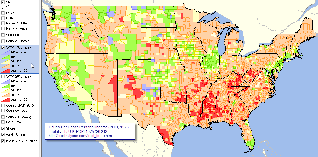 Click graphic for larger view. View developed with CV XE GIS software. Patterns of the County-to-U.S. PCPI Index -- 2015 The following graphic shows patterns of the county-to-U.S. PCPI index based on the 2015 PCPI. Index values shown in the legend have been computed by dividing the county 2015 PCPI by the U.S. 2015 PCPI ($48,112) and multiplying by 100. 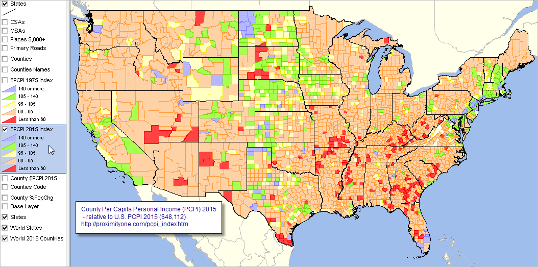 Click graphic for larger view. View developed with CV XE GIS software. Limitations & Opportunities Limitations of possible insights from using these data include: • Only one year is used to compare the 40-year change in the index. .. possibly a 2-3 year average should be considered; e.g., 1974-75 and 2014-15. • In particular, 2015 values for counties having oil shale based economies may be misleading. Using only PCPI may mask the more important underlying change such as change in transfer payments, a component of personal income. The map graphics illustrate the potential for more extensive and different geospatial analyses. Using a regional drill-down, stakeholders may be interested using a PCPI base geography as the state or metropolitan area, Support Using these Resources We are available to support your every need to make the Situation & Outlook a productive resource for you. We available by telephone, e-mail, Web session and in other ways to make your experience outstanding. Join us in a Data Analytics Lab session. Each informal session is focused on a specific topic. The open structure also provides for Q&A and discussion of application issues of interest to participants. ProximityOne User Group Join the ProximityOne User Group to keep up-to-date with new developments relating to geographic-demographic-economic decision-making information resources. Receive updates and access to tools and resources available only to members. Use this form to join the User Group. Additional Information ProximityOne develops geographic-demographic-economic data and analytical tools and helps organizations knit together and use diverse data in a decision-making and analytical framework. We develop custom demographic/economic estimates and projections, develop geographic and geocoded address files, and assist with impact and geospatial analyses. Wide-ranging organizations use our tools (software, data, methodologies) to analyze their own data integrated with other data. Follow ProximityOne on Twitter at www.twitter.com/proximityone. Contact ProximityOne (888-364-7656) with questions about data covered in this section or to discuss custom estimates, projections or analyses for your areas of interest. |
|
|