
|
|
|
|
ZIP Code to Congressional District 114 Equivalence Table -- relating ZIP codes to congressional districts
Visual Relationship: ZIP Code 30331 and Georgia CD GA05 & GA13 The graphic below shows Atlanta, GA area 114th congressional districts (black bold boundary, yellow label) and ZIP code areas (red boundary, white label). ZIP code 30331 is shown at the pointer and intersects GA05 and GA13 congressional districts. ZIP 30331 is mainly located in GA05 but also extends into GA13.  - view developed with ProximityOne CV XE GIS and related GIS project. The above map also shows a thematic pattern of the percent citizen voting age population by congressional district. See color legend at left of map for color/interval values. See more about the citizen voting age population by congressional district. Table View; Relating ZIP Code 30331 and Georgia CD GA05 & GA13 The relationship between ZIP code area 30331 and intersecting congressional districts can also be shown using the interactive table. The following graphic illustrates how the ZIP code can be related to the congressional districts in a tabular manner. 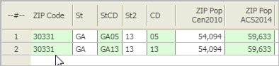 ZIP Code to 114th Congressional District Equivalence Table - Interactive Table Click ShowAll button between Find/Queries. Use mouseover on column header to view column description. See usage notes below ranking table. See related ranking tables -- http://proximityone.com/rankingtables.htm. Usage Notes • The table shows all intersecting combinations of ZIP code areas and congressional districts. • Click ShowAll button to reset table; click ShowAll button between queries. • Population columns show total population of the ZIP code area. - ZIP Pop Cen2010 is the Census 2010 population for the ZIP code. - ZIP Pop ACS2014 is the ACS 2014 5-year population estimate for the ZIP code. Support Using these Resources Learn more about demographic economic data and related analytical tools. Join us in a Data Analytics Lab session. There is no fee for these Web sessions. Each informal session is focused on a specific topic. The open structure also provides for Q&A and discussion of application issues of interest to participants. ProximityOne User Group Join the ProximityOne User Group to keep up-to-date with new developments relating to geographic-demographic-economic decision-making information resources. Receive updates and access to tools and resources available only to members. Use this form to join the User Group. Additional Information ProximityOne develops geographic-demographic-economic data and analytical tools and helps organizations knit together and use diverse data in a decision-making and analytical framework. We develop custom demographic/economic estimates and projections, develop geographic and geocoded address files, and assist with impact and geospatial analyses. Wide-ranging organizations use our software, data and methodologies to analyze their own data integrated with other data. Follow ProximityOne on Twitter at www.twitter.com/proximityone. Contact ProximityOne (888-364-7656) with questions about data covered in this section or to discuss custom estimates, projections or analyses for your areas of interest. |
|
|