|
|
|
Situation & Outlook Related Sections - Applications Gallery - States - School Districts - Metros - Legislative Districts - Counties - Tracts/Neighborhoods - Block Groups - Census Blocks - ZIP Codes - Urban Areas Estimates-Projections - 2060 Demographic ... all county interactive table - 2030 Demographic-Economic - Single Year of Age GIS Thematic Mapping Visual Analysis Tools Ranking Tables National Scope Demographic Change 2000-2010 - States - Metros - Congressional District - School Districts - Counties - Cities/Places - Census Tracts |
Analyzing Characteristics of 113th/114th Congressional Districts ... resources to assess the state of economy, social patterns, education and special interests
• 115th Congressional DIstricts • See more at the Congressional DIstricts main section Join the Congressional District-State Legislative District (CDSLD) Group .. be a part of the community. .. click here to join .. there is no cost. About the 113th/114th Congressional Districts The 2014 median household income ($MHI) among the 114th Congressional Districts ranged from $24,429 (NY15) to $115,291 (VA10). See the interactive analysis table to view/rank/compare wide-ranging demographic-economic characteristics of the 114th Congressional Districts. The 113th Congressional District boundaries reflect redistricting, as applicable, based on Census 2010 results. Use the interactive table in this section to view names of congresspeople elected to 113th congressional districts and associated party affiliation. States made no changes to the 113th Congressional Districts boundaries for the 114th Congress. The boundaries of the 113th and 114th Congressional Districts are the same. View thematic pattern maps of economic prosperity by neighborhood for each 113th/114th Congressional District ... http://proximityone.com/cdgallery/guide/ Updates -- scroll section
09.25.15. Congressional District Median Income & Housing Value: 2013-2014
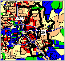
... examining patterns & characteristics of individual & all districts ... incumbent, party, median income, median housing value; annual change ... use interactive table -- http://proximityone.com/cd114_2013_2014.htm ... visualizing patterns ... geospatial analysis ... 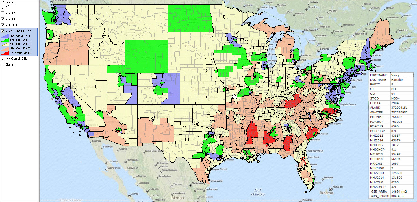 02.14.15. New Voting Rights Act Demographics ... ACS 2009-13 Citizen Voting Age Population (CVAP) estimates by race/origin ... examining relationships between legislative districts, census tracts, voting districts & census blocks ... interactive table -- http://proximityone.com/cvap_tracts_2013.htm ... visualizing patterns ... Los Angeles area ... ... 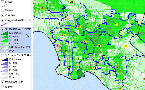 09.29.14. A Century of County Population Change: 1910 to 2010 ... decade to decade population change ... interactive table -- http://proximityone.com/ctypopchg.htm ... visualizing patterns ... Dallas metro region ... ...  09.18.14. 2013 Congressional District Demographics ... most recent demographic-economic estimates for each/all 113th CDs ... API-based subject matter access ... interactive table -- http://proximityone.com/acs2013.htm#table 07.26.14. Making Custom Congressional District Maps ... http://proximityone.com/cd113_maps.htm ... download & use GIS resources; make custom congressional district maps ... examine urban/rural patterns by congressional district ... TX CD 22 by county & urban/rural patterns ... 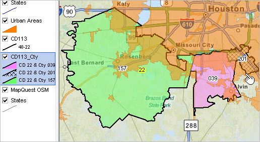 06.01.14. School Age Population Characteristics by 113th Congressional District ... examine school district characteristics within congressional districts. ... see more at Children's Demographics ... click graphic for larger view and details. ...  03.24.14. Geocode Address Data with 113th Congressional District ... what congressional district is my address located in? state legislative district? voting district? ... APIGeocoder: batch & interactive geocoding ... API-based geocoder can code addresses with wide-ranging geography & demographic-economic attributes. 02.17.14. 113th Congressional District Demographic Interactive Tables ... ACS 2012 1-year 113th Congressional District demographic-economic ranking tables ... General Demographics -- http://proximityone.com/cd11312dp1.htm ... Social Characteristics -- http://proximityone.com/cd11312dp2.htm ... Economic Characteristics -- http://proximityone.com/cd11312dp3.htm ... Housing Characterictics -- http://proximityone.com/cd11312dp4.htm 11.06.13. State Legislative Districts Urban/Rural Characteristics ... examine America's 6,558 state legislative districts by urban/rural population & land area ... interactive table: http://proximityone.com/sld2013.htm 09.23.13. ACS 2012 Demographic-Economic Updates ... new American Community Survey (ACS) 2012 1-year estimates - demographic-economic updates for each 113th Congressional District ... use the interactive table to examine demographic-economic patterns - see http://proximityone.com/cd_acs12.htm 09.20.13. 2012 Elections & Vote by Candidate ... Presidential, Senatorial and each Congressional election ... vote count and percent by election, party, candidate ... interactive analysis table: http://proximityone.com/2012elections.htm 04.11.13. Census 2010 SF1 Released for 113th Congressional Districts ... population by age, gender, race/origin; household type & relationship; group quarters ... housing units by own/rent/tenure; vacancy; related attributes ... retabulated for the congressional district boundaries of the 113th Congress ... more about Summary File 1 (SF1): http://proximityone.com/cen2010_sf1.htm ... check back for details on access 03.06.13. 113th Congressional District Demographic Interactive Tables ... ACS 2011 1-year 113th Congressional District demographic-economic ranking tables ... General Demographics -- http://proximityone.com/cd11311dp1.htm ... Social Characteristics -- http://proximityone.com/cd11311dp2.htm ... Economic Characteristics -- http://proximityone.com/cd11311dp3.htm ... Housing Characterictics -- http://proximityone.com/cd11311dp4.htm 03.04.13. 113th Congressional District Demographic-Economic Profiles ... New ACS 2011 1-year 113th Congressional District demographic-economic profiles ... View example for New York 12th -- http://proximityone.com/cd113_profiles.htm ... Data available for single districts, sets of districts or all districts in various formats ... Contact us for more information (mention ACS 2011 CD Profiles in text section) 03.01.13. Impact of Sequester on School Districts by Congressional District ... mapping patterns of school districts by percent revenue from Federal sources ... view districts most vulnerable to reductions in Federal funding ... school districts shown in context of 113th Congressional Districts ... see http://proximityone.com/sdfa_cd.htm 02.01.13. Citizen Voting Age Population Patterns by Census Tract ... ACS 2011 5-year special tabulation estimates ... citizen voting age population by race/ethnicity ... using these data with tools to analyze compliance with Voting Rights Act ... interactive ranking table ... http://proximityone.com/tracts_cvap.htm ... visual analysis using GIS tools http://proximityone.com/cdgallery/guide/cvap.htm 01.28.13. 113th Congressional District Urban/Rural Characteristics ... new urban/rural data developed using Census 2010 Summary File 1 data. ... urban and rural population and housing data summarized by 113th Congressional District. ... http://proximityone.com/cd113_2010_ur.htm. 01.25.13. 113th Congressional District Demographics ... new data based on American Community Survey 2011 1-year estimates. ... tabulations for the new 113th congressional district boundaries. ... http://proximityone.com/cd113_demographics.htm. 01.24.13. ZIP Code to 113th Congressional District Equivalencing ... ZIP Code to 113th Congressional District equivalence CSV file now available. ... Use these data to determine 5-digit ZIP Codes that intersect with 113th CDs. ... Web-based interactive query/view table available later in week. ... Contact us for additional information (mention ZIP-CD113 data). 01.15.13. CD Gallery Updated: 113th Congress Congressional District Maps ... State by congressional district maps for all states; sub-state zoom-in for many states. ... District specific focus maps available in all states. - district focus maps show CD boundary and thematic pattern map. - thematic pattern: economic prosperity (median household income) by census tract. ... http://proximityone.com/cdgallery/guide/ 01.14.13. Census 2010 Summary File 1 & Congressional District 113 Update
12.04.12. 113th Congressional Districts & School District Finances ... School district thematic maps (percent Federal revenue) in context of 113th CD boundaries. ... School district-CD map views: http://proximityone.com/sdfa_cd.htm. ... Applications Gallery: http://proximityone.com/gallery/guide/113th_congressional_districts.htm. Analyzing Pattern 113th Congressional Districts Using GIS Tools The national scope 113th Congressional District (CD) boundaries are now available in shapefile structure for use in GIS/mapping applications. These related new shapefiles and data are also available: > Corresponding state upper (SU) and lower (SL) house boundary shapefiles. > Census 2010 census block to 113th CD, SU and SL equivalence files. > ProximityOne Census 2010 demographics data by 113th CD, SU and SL. > ProximityOne ZIP Code-113th CD, SU and SL equivalence file and demographics. ... Contact us (888-364-7656) for mapping, GIS projects, data integration and analysis. 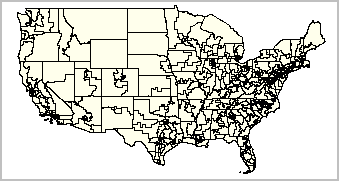
113th Congressional Districts ... click graphic for larger view. Larger map shows CD labels. Applications gallery: http://proximityone.com/gallery/guide/113th_congressional_districts.htm. View congressional district by neighborhood maps of economic prosperity (median household income) by census tract. ... choose by state or select district from contents: http://proximityone.com/cdgallery/guide/overview.htm 113th/114th Congressional Districts Interactive Ranking Table Click column header to sort; again to sort other direction. Usage notes below table. Click ShowAll button between queries. Click link in right column to view district map ... Create custom CD maps - opens new page View CD income & housing values interactive table - opens new page See related Ranking Tables Main Page Additional Information ProximityOne develops geographic-demographic-economic data and analytical tools and helps organizations knit together and use diverse data in a decision-making and analytical framework. We develop custom demographic/economic estimates and projections, develop geographic and geocoded address files, and assist with impact and geospatial analyses. Wide-ranging organizations use our tools (software, data, methodologies) to analyze their own data integrated with other data. Contact Proximity (888-364-7656) with questions about data covered in this section or to discuss custom estimates, projections or analyses for your areas of interest. |
|
|