
|
.. a look at mass killings in the U.S. .. examining patterns .. interpretative data analytics .. did you know? .. 583 mass killings have occurred in the U.S. since 2006? .. that 304 of the 435 118th Congressional Districts have experienced one or more mass killings since 2006? Many of these districts have experienced 5 or more such incidents. Learn more about these incidents using the interactive table below. Congressional Districts referenced here are as of the 118th Congressional Districts (CDs). The 3 CDs with the largest number of mass killings are: • Kansas 02 .. 7 • Ohio 11 .. 6 • Louisiana 2 .. 6 Eight CDs followed these 3 with 5 mass killings each. The pattern of mass killings is random and unpredictable, but there are some common elements — as this database shows. This document builds on data developed through a collaboration between The Associated Press and USA Today in partnership with Northeastern University. It is focused on mass killings in the United States starting in 2006. Patterns of Mass Killings by Congressional District .. the graphic below shows mass killing incidents as markers. .. 118th Congressional Districts are shown as a thematic pattern of the number of incidents by CD. .. see legend at left of map for color patterns. 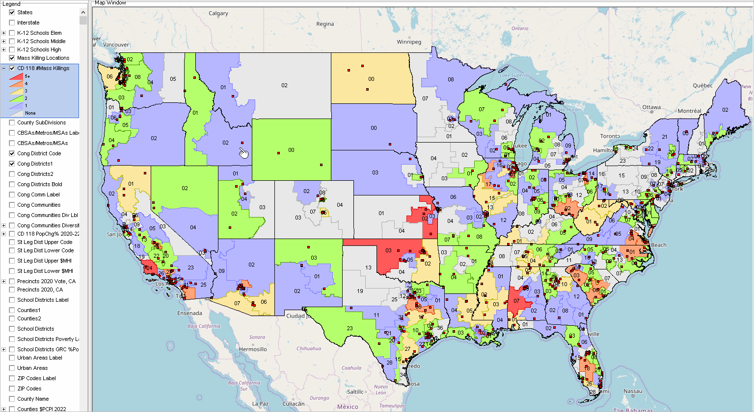 .. click graphic for larger view (desktop with full-screen browser recommended). .. view developed using VDA GIS tools. Zoom-in View of Los Angeles-Orange County, CA Area .. the graphic below shows mass killing incidents as markers. .. 118th Congressional Districts are shown as a thematic pattern of the number of incidents by CD. .. see inset legend for interval-color patterns. 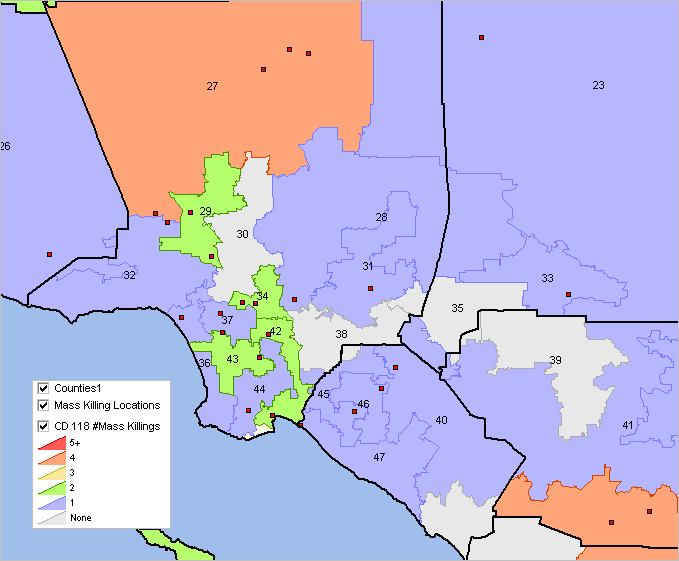 .. view developed using VDA GIS tools. Zoom-in View of Las Vegas, NV Area .. the graphic below shows mass killing incidents as markers. .. 118th Congressional Districts are shown as a thematic pattern of the number of incidents by CD. .. see inset legend for interval-color patterns. 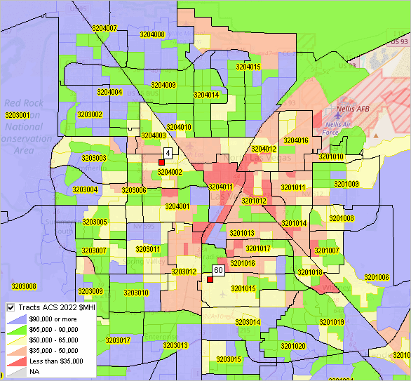 .. view developed using VDA GIS tools. Join us in the every Wednesday Congressional Districts & Congressional Communities Analytics web session. Learn more about accessing and using congressional district demographics, demographic change and Congressional Communities. Mass Killings & 118th Congressional District Patterns Interactive Table .. goto top The table below contains one row for each mass killing. Left-most columns are attributes of mass killing; right-most columns are attibutes of CD location. Use the buttons & tools below the table for most effective use of this table and data. Click ShowAll button between Find/Queries. Use mouseover on column header to view column description. See usage notes below table. Usage Notes CD items in this table are based on American Community Survey 2022 1 year (ACS2022) estimates. .. those estimates are new as of 9/14/23 and will the most current CD118 demographic estimates until 9/24. The table also contains the Census 2020 population and shows the population change 2020 to 2022. • If table not showing any rows; click ShowAll button below table. • Use vertical and horizontal scroll bars to navigate up/down or left/right. • Adjust column widths using column divider between header cells. Items in Table
- Incident
- Date - City - County - St - Number of Offenders - Number of Victims1 - Number of Victims2 - First COD - Second COD - AK_47 - AR_15 - Type - Situation - Location 1 - Location 2 - Tract Code CD Attributes - Incumbent - Stab USPS state abbreviation - St State FIPS code - CD Congressional Districts code - StCD State FIPS and Congressional Districts code - Party - Population 2020 - Population 2022 - Population Change 2020-2022 - Population %Change 2020-2022 - Male, 2022 - Female, 2022 - White alone, 2022 - Black alone 2022 - AmerInd/AlNat alone, 2022 - Asian alone 2022 - NHOPI1 alone 2022 - OthRace 2022 - MultiRace, 2022 - Hispanic, 2022 - Pop 65+ 2022 - Pop in HH 2022 - Households 2022 - Families 2022 - Pop 25+ 2022 - HS Grads M 2022 - HS Grads F 2022 - Total Housing Units 2022 - Own Occ Hsg Units 2022 - Rnt Occ Hsg Units 2022 - Vacants units 2022 - Med HH Income 2022 - Med Fam Income 2022 - Med Hsg Value 2022 - Med Rent 2022 - Gini Index 2022 - CD Name About this Section .. goto top The 118th Congress runs from January 1, 2023 through December 31, 2024. The 2024 House of Representatives elections will be held on November 5, 2024, to elect representatives from all 435 congressional districts for the 119th Congress. Those elected will serve in the 119th Congress with seats apportioned among the states based on the Census 2020. Using census block level data from Census 2020 each state redistricts their apportioned number seats with new boundaries for the 2024 elections. While most 119th congressional district boundaries will be the same as the 118th boundaries, some change due to revisions. The 118th CD boundaries are provided to the Census Bureau by states and are integrated into the TIGER public use digital map database released in 2023. More detailed 118th congressional district demographic-economic data are available from the ACS 2022 released in 2023. This section is developed/updated by Warren Glimpse .. connect via LinkedIn. Schedule a talk/briefing by Warren for your group (face-to-face or Web) on Census-related topics, Census 2020, congressional districts, redistricting or related topics -- adjusted to your theme or sphere of interest. Send a message via LinkedIn, use this form (add note in text section) or call 888.364.7656. Terms of Use .. goto top There are no warranties about any aspect of this web section or related sections or data. The user is responsible for any use of any aspect of this web section or related sections or data. Support Using these Resources .. goto top Learn more about accessing and using demographic-economic data and related analytical tools. Join us in a Data Analytics Lab session. There is no fee for these one-hour Web sessions. Each informal session is focused on a specific topic. The open structure also provides for Q&A and discussion of application issues of interest to participants. ProximityOne User Group Join the ProximityOne User Group to keep up-to-date with new developments relating to geographic-demographic-economic decision-making information resources. Receive updates and access to tools and resources available only to members. Use this form to join the User Group. Additional Information ProximityOne develops geographic-demographic-economic data and analytical tools and helps organizations knit together and use diverse data in a decision-making and analytical framework. We develop custom demographic/economic estimates and projections, develop geographic and geocoded address files, and assist with impact and geospatial analyses. Wide-ranging organizations use our tools (software, data, methodologies) to analyze their own data integrated with other data. Follow ProximityOne on Twitter at www.twitter.com/proximityone. Contact ProximityOne (888-364-7656) with questions about data covered in this section or to discuss custom estimates, projections or analyses for your areas of interest. |
|
|