
|
|
|
-- tools to access, view, integrate & analyze data resources GeoStat is a powerful resource to access and integrate multi-sourced Federal and other geostatistical data in a manner that facilities creating and applying insights -- data-driven planning, management and analysis. Supporting access to, integration and use of Census 2010, American Community Survey (ACS), the Regional Economic Information System, ProximityOne estimates and projections and other statistical programs now, GeoStat will progressively provide access to Census 2020. An important feature of GeoStat, providing API-based access to these data, is the ability to integrate of data from diverse statistical programs. Unlike for example the Census Bureau tools focused only on Census programs. Review the start-up and usage orientation below or skip to the operations details below. Topics 01 Overview 02 Operations 07 Terms & Concepts 08 Metadata Files 09 Installation 10 Version Features 11 Terms of Use GeoStat Start-Up View - click graphic for larger view. 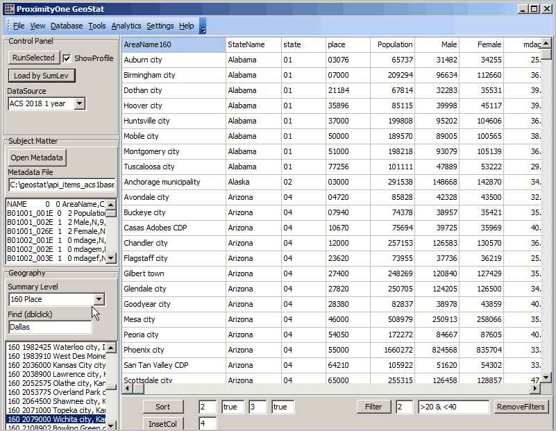 After installing GeoStat (see details below) on a Windows computer, the start-up view shown above appears. The grid shows a view of all cities included in the American Community Survey 2018 1 year estimates (ACS2018). There is one row for each city with subject matter arrayed in the columns. The subject matter list is determined by the user. Creating this display, you can now perform analytically oriented operations on these data and/or save the current grid as a dBase, Excel, delimited or fixed length field text file. Saved as a dBase file, the data may be integrated into a shapefile and added to a GIS project. Optionally create a thematic map view or perform geospatial analytics. Designed and supported for use with the ProximityOne CV XE GIS, the data/files created using GeoStat may be used with any GIS software that uses shapefiles. Selecting Geography Select the type of geography (summary level) using the Summary Level drop-down in the panel at the left of the grid. By selecting Congressional Districts then clicking the "Load from SumLev" See example. Scope of Geography -- 1 in rightmost columns denotes availability
Comparative Analysis Starting with view shown above, create a comparative analysis view for a set of cities as shown in the graphic below. - click graphic for larger view. 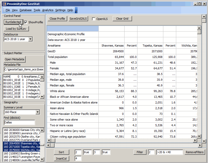 Multi-select areas of interest in the Geography Listbox and click the Run from Selections button at the top of control panel. In this example three cities are selected. The subject matter is the same as shown in the Subject Matter listbox and used in the previous example/graphic for cities. Scope of Subject Matter Use GeoStat to access any of the data for any of the geography in the ACS2017 or ACS2018 summary files. Level 2 users can access a broader array of data (many statistical programs) and access an extended set of features. Two introductory examples. You want a file that contains the most recent estimates of median household income and related items for all 116th congressional districts. With GeoStat running, follow these steps (below -- three clicks) to create that file. Get these data for any type of tabulation geography (summary level) for which the ACS 2018 1-year estimates are tabulated (see list). This version of GeoStat is focused on the American Community Survey 1-year 2017 and 2018 demographic-economic data. 02 Operations .. goto top 02.1 User Interface 02.2 Start-up 02.1. User Interface .. goto top 1.1. Left panel 1.1.1. Control panel Run Selected runs listbox1 for each item selected Load by Sumlev loads all items in listbox1 to grid1 DataSource 1.1.2. Subject Matter 1.1.3. Geography 1.2. Main Grid (Grid1) 1.3. Profile Grid (Grid2) Shows only when ListBox1 is dbl-clicked 1.4. Main Menu 02.2. Start-up .. goto top 2.1. Load by SumLev 07 Terms & Concepts .. goto top Metadata Summary Level Table 08 Metadata File .. goto top The metadata file is a text file that contains a row for each subject matter item to be accessed. The structure of the metadata file is fixed and must follow rules listed below. There are two metadata files included with the installer. A metadata file may contain up to 50 items. The metadata file must contain these fields: - Subject matter item field name; left-justified, cols 1-13 - Tabs in profile grid display; col 14 - Sequence number in metadata file of item to be used as divisor for percentages; cols 7-8; right-justified number - Field name and field attributes; cols 28-28; left-justified. .. field name must be 10 characters or less, no spaces or special characters. - Descriptive name for the item to be used in profile displays/files. Rules: The following section shows the default metadata file. The numbers that appear above the NAME row are not included in the file. They are used here to show field locations within the record (as enumerated above). NAME is required as the first field and must be the first row/record in the file. Default MetaData File: a selection or population & household items ... this file is included with the installer.
         1         2         3         4
1234567890123456789012345678901234567890
NAME         0   0 AreaName,C,120,0   AreaName
B01001_001E  0   2 Population,N,9,0   Total population
B02001_002E  1   2 White,N,9,0        White alone
B02001_003E  1   2 Black,N,9,0        Black or African American alone
B02001_004E  1   2 AIAN,N,9,0         American Indian & Alaska Native alone
B02001_005E  1   2 Asian,N,9,0        Asian alone
B02001_006E  1   2 NHOPI,N,9,0        Native Hawaiian & Other Pacific Islander alone
B02001_007E  1   2 Pop_Other,N,9,0    Some other race alone
B02001_008E  1   2 Pop_tom,N,9,0      Two or more races
B03003_003E  1   2 Hispanic,N,9,0     Hispanic or Latino (any race)
B29001_001E  1   2 CVAP,N,9,0         Citizen voting age population
B19013_001E  0   0 MHI,N,9,0          Median household income
B19301_001E  0   0 PCI,N,9,0          Per capita income
B25077_001E  0   0 MdHsgVal,N,9,0     Median housing value
B25064_001E  0   0 MdRent,N,9,0       Median gross rent
B19083_001E  0   0 GiniIndex,N,9,4    Gini index of income inequality
B25001_001E  0  17 HsgUnits,N,9,0     Total housing units
B25002_002E  1  17 Households,N,9,0   Occupied units (households)
B25003_002E  2  17 OwnOcc,N,9,0       Owner occupied units
B25003_003E  2  17 RentOcc,N,9,0      Renter occupied units
B25002_003E  1  17 Vacant,N,9,0       Vacant units
Population by Gender and Age Group -- ACS Table B01001 ... this file is included with the installer.
         1         2         3         4
1234567890123456789012345678901234567890
NAME         0   0 AreaName,C,120,0   AreaName
B01001_001E  2   2 TotPop,N,9,0       Total Population
B01001_002E  2   2 MalePop,N,9,0      Male Population
B01001_003E  2   3 Male0004,N,9,0     Male Under 5 years
B01001_004E  2   3 Male0509,N,9,0     Male 5 to 9 years
B01001_005E  2   3 Male1014,N,9,0     Male 10 to 14 years
B01001_006E  2   3 Male1517,N,9,0     Male 15 to 17 years
B01001_007E  2   3 Male1819,N,9,0     Male 18 and 19 years
B01001_008E  2   3 Male2020,N,9,0     Male 20 years
B01001_009E  2   3 Male2121,N,9,0     Male 21 years
B01001_010E  2   3 Male2224,N,9,0     Male 22 to 24 years
B01001_011E  2   3 Male2529,N,9,0     Male 25 to 29 years
B01001_012E  2   3 Male3035,N,9,0     Male 30 to 34 years
B01001_013E  2   3 Male3539,N,9,0     Male 35 to 39 years
B01001_014E  2   3 Male4044,N,9,0     Male 40 to 44 years
B01001_015E  2   3 Male4549,N,9,0     Male 45 to 49 years
B01001_016E  2   3 Male5054,N,9,0     Male 50 to 54 years
B01001_017E  2   3 Male5559,N,9,0     Male 55 to 59 years
B01001_018E  2   3 Male6061,N,9,0     Male 60 and 61 years
B01001_019E  2   3 Male6264,N,9,0     Male 62 to 64 years
B01001_020E  2   3 Male6566,N,9,0     Male 65 and 66 years
B01001_021E  2   3 Male6769,N,9,0     Male 67 to 69 years
B01001_022E  2   3 Male7074,N,9,0     Male 70 to 74 years
B01001_023E  2   3 Male7579,N,9,0     Male 75 to 79 years
B01001_024E  2   3 Male8084,N,9,0     Male 80 to 84 years
B01001_025E  2   3 Male85up,N,9,0     Male 85 years and over
B01001_026E  2   2 FemalePop,N,9,0    Female Population
B01001_027E  2   3 Female0004,N,9,0   Female Under 5 years
B01001_028E  2   3 Female0509,N,9,0   Female 5 to 9 years
B01001_029E  2   3 Female1014,N,9,0   Female 10 to 14 years
B01001_030E  2   3 Female1517,N,9,0   Female 15 to 17 years
B01001_031E  2   3 Female1819,N,9,0   Female 18 and 19 years
B01001_032E  2   3 Female2020,N,9,0   Female 20 years
B01001_033E  2   3 Female2121,N,9,0   Female 21 years
B01001_034E  2   3 Female2224,N,9,0   Female 22 to 24 years
B01001_035E  2   3 Female2529,N,9,0   Female 25 to 29 years
B01001_036E  2   3 Female3034,N,9,0   Female 30 to 34 years
B01001_037E  2   3 Female3539,N,9,0   Female 35 to 39 years
B01001_038E  2   3 Female4044,N,9,0   Female 40 to 44 years
B01001_039E  2   3 Female4549,N,9,0   Female 45 to 49 years
B01001_040E  2   3 Female5054,N,9,0   Female 50 to 54 years
B01001_041E  2   3 Female5559,N,9,0   Female 55 to 59 years
B01001_042E  2   3 Female6061,N,9,0   Female 60 and 61 years
B01001_043E  2   3 Female6264,N,9,0   Female 62 to 64 years
B01001_044E  2   3 Female6566,N,9,0   Female 65 and 66 years
B01001_045E  2   3 Female6769,N,9,0   Female 67 to 69 years
B01001_046E  2   3 Female7074,N,9,0   Female 70 to 74 years
B01001_047E  2   3 Female7579,N,9,0   Female 75 to 79 years
B01001_048E  2   3 Female8084,N,9,0   Female 80 to 84 years
B01001_049E  2   3 Female85up,N,9,0   Female 85 years and over
09 Installation .. goto topInstall GeoStat on a Windows computer by clicking this link and following the prompts. Taking all default settings is recommended. The installer requires your User Group UserID. Join now. No fee. 10 Version Features .. goto top Level 1 • Limited to 50 subject matter items per individual run. • Operates only with ACS 2017 and ACS 2018 1-year detailed summary data. • Summary levels supported: .. 010 United States .. 040 States .. 050 Counties .. 160 Cities/Places .. 310 CBSAs: Metropolitan Statisitcal Areas; Micropolitan Statistical Areas .. 500 116th Congressional Districts Level 2 • Level 1 features plus additional features. • Up to 250 subject matter items per individual run. • ACS 2017 and ACS 2018 1-year and 5-year detailed summary data. .. ACS 2018 5-year data available later December 2019 as released by Census • All summary levels supported .. to block group for ACS .. to census block for Census 2010/Census 2020 11 Terms of Use .. goto top • GeoStat is a proprietary product of ProximityOne. • GeoStat may be be redistributed. • There are no warranties of any type regarding any aspect of GeoStat. • A user of GeoStat is solely responsible for any use made of GeoStat. Support Using these Resources .. goto top Learn more about demographic economic data and related analytical tools. Join us in a Decision-Making Information Web session. There is no fee for these one-hour Web sessions. Each informal session is focused on a specific topic. The open structure also provides for Q&A and discussion of application issues of interest to participants. ProximityOne User Group Join the ProximityOne User Group to keep up-to-date with new developments relating to geographic-demographic-economic decision-making information resources. Receive updates and access to tools and resources available only to members. Use this form to join the User Group. There is no fee. Additional Information ProximityOne develops geographic-demographic-economic data and analytical tools and helps organizations knit together and use diverse data in a decision-making and analytical framework. We develop custom demographic/economic estimates and projections, develop geographic and geocoded address files, and assist with impact and geospatial analyses. Wide-ranging organizations use our tools (software, data, methodologies) to analyze their own data integrated with other data. Follow ProximityOne on Twitter at www.twitter.com/proximityone. Contact ProximityOne (888-364-7656) with questions about data covered in this section or to discuss custom estimates, projections or analyses for your areas of interest. |
|
|