
|
|
|
School District Data Analytics -- 2015 Enrollment Characteristics; Largest 1,016 School Districts
September 2016. This section is focused on public and private school enrollment by school district. While school district enrollment is reported by school districts, only public school enrollment is reported. Public and private school enrollment are available by district from the American Community Survey (ACS 2015). These data show enrollment of residents of the district whether enrolled in that district or otherwise. Enrollment data are provided for preschool, K-12 and college and not enrolled. This section developed by Warren Glimpse. ProximityOne develops school and school district demographic-economic estimates and projections; GIS, mapping and geospatial analysis; and analytical services. Use this form to share comments and questions about these data or this section. This section is focused on tools, resources and methods that you can use to access, integrate and analyze school district enrollment characteristics • Go to interactive table below in this section. .. related tables (same set of districts): • General Demographics • Social Characteristics • Economic Characteristics • Housing Characteristics The largest school districts are those that have total population of 65,000 or more. These data provide information and insights not available by examining data on students and schools alone -- or any other data. See more about the importance of these data. Data reviewed in this section are based on the American Community Survey (ACS) 2015 1-year estimates for school districts defined as of the 2013-14 school year. See notes on importance of these data. See similar ranking tables for: Census Tracts | ZIP Codes | State, Metro & County. Largest School Districts 2015 This view shows school districts (red markers) having ACS 2015 population 65,000 or more. Click graphic for larger view. Expand browser window for best quality view. Larger view shows metros (MSAs) with semi-transparent fill pattern. See district locations in context of metros. Use related GIS project to examine patterns and gain insights into school district patterns using geospatial data analytics tools. View school districts as areas in context of other geography and your data. Zoom-in for regional views; label geography with names or attributes. 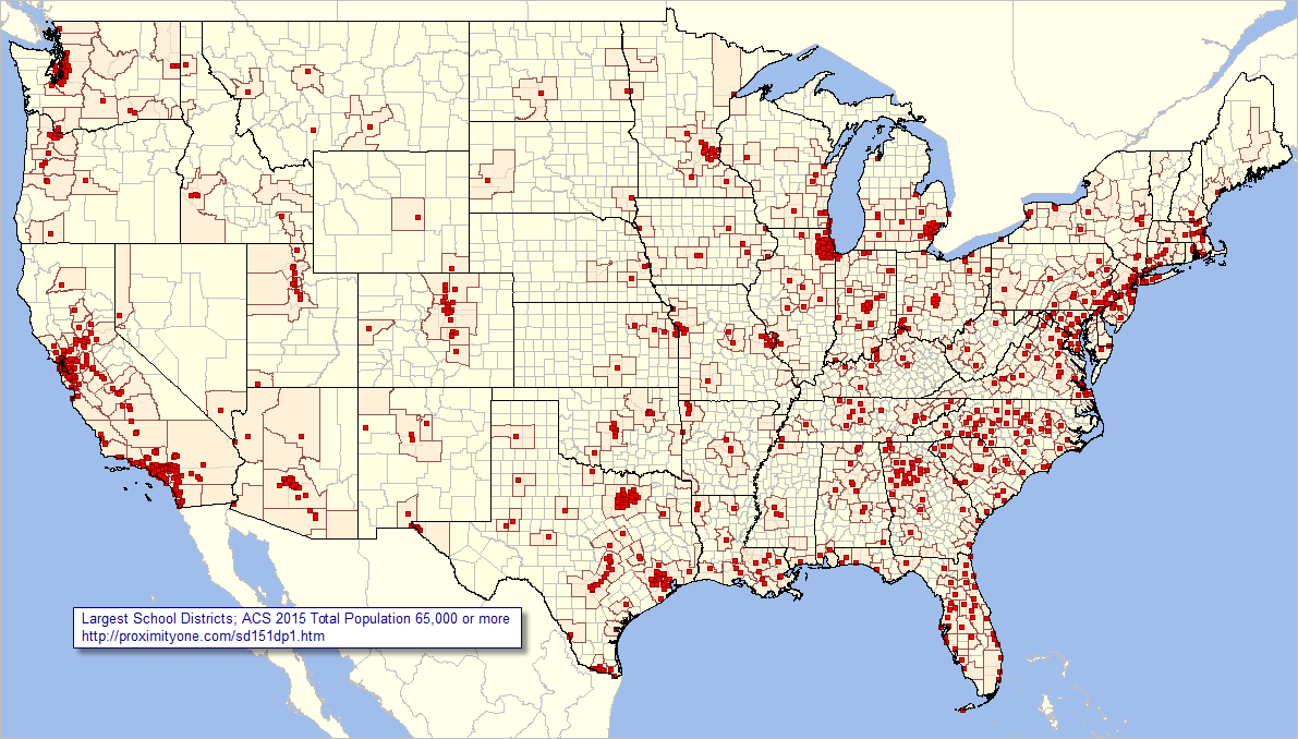 - View developed using CV XE GIS and related GIS project. Using the Interactive Table Use the interactive table below to view, query, rank, compare enrollment for these areas. Use buttons and operations below table to control data displays. Click ShowAll button to reset table. Click "K12 Public Enrl" button to view K-12 public enrollment columns. School District 2015 Enrollment Characteristics interactive table Click ShowAll button between Find/Queries. Use mouseover on column header to view column description. See usage notes below table. See related tables -- http://proximityone.com/rankingtables.htm. Usage Notes • If table not showing any rows; click ShowAll button below table. • Use vertical and horizontal scroll bars to navigate up/down or left/right. • Adjust column widths using column divider between header cells. • CBSA> button -- use to select districts in a specified metro/CBSA .. get metro 5-character code here .. paste the 5-character metro code in the edit box to right of CBSA> button. .. overwriting the value 19100. .. click the CBSA> button ... table refreshes with all districts in specified metro. • Find Name> button -- use to select district based on exact spelling of partial name in column 1. .. Key in exact up/low case spelling of partial name of district in the edit box to right of Find Name> button. .. overwriting the value Dallas. .. click the Find Name> button ... table refreshes with all districts with matched spelling in column 1. • Selected columns -- "K12 Public Enrl" below the table to show selected K-12 public enrollment columns; .. click "All columns" button to restore view to all columns. • All items are estimates for 2015. • Click ShowAll button between specific area queries. • Cells with negative value could not be estimated (for this geography and this time frame). Columns/Subject Matter Items General characteristics Name State Code Type -- elementary, secondary, unified CBSA -- Metro code -- Code-Based Statistical Area code Total Population Population Age 5-17 Enrollment Total K-12 Enrollment Public K-12 Enrollment Private K-12 Population 3 years and over Total Enrolled in school: Enrolled in nursery school, preschool: Public school Private school Enrolled in kindergarten: Public school Private school Enrolled in grade 1 to grade 4: Public school Private school Enrolled in grade 5 to grade 8: Public school Private school Enrolled in grade 9 to grade 12: Public school Private school Enrolled in college undergraduate years: Public school Private school Enrolled in graduate or professional school: Public school Private school Not enrolled in school Selecting Districts within a Metro/CBSA Proceed with these steps to view districts within a selected metro/CBSA: • Click ShowAll button below table. • Click the CBSA> button (using the default Dallas metro CBSA code 19100). Examine a metro of interest -- get metro 5-character code here .. • Click ShowAll button below table. • Paste the 5-character metro code in the edit box to right of CBSA> button. .. overwriting the value 19100. • Click the CBSA> button. Use find codes/names to determine census tract, city/place, school district etc. geocode/area name based on address. Selected Characteristics Largest 10 Districts (based on 2015 total K-12 enrollment) Replicate the following table using the interactive table above. View more detail. Rank on different columns. The largest 10 school districts have 2015 total K-12 enrollment of 4,428,977. Click link in CBSA column to view characteristics of corresponding metro.
School Districts Tabulated in ACS 2015 ACS 2015 data are tabulated for 14,650 school districts (among many other wide-ranging geography) The following table shows the number of districts for which 1-year estimates and 5-year estimates are tabulated. There are 1,016 districts for which 1-year estimates were tabulated.
Importance of School District Demographic-Economic Data The American Community Survey provides "richer" demographic-economic characteristics for national scope school districts. While Census 2010 provides data similar to those items in the General Demographics section, only ACS sourced data provide details on topics such as income and poverty, labor force and employment, housing value and costs, educational participation and attainment, language spoken at home, among many related items. The approximate 600 items accessible via the dataset are supplemented by a wide range of additional subject matter. ACS school district data are updated annually in December of each year for each/all school districts. ProximityOne User Group Join the ProximityOne User Group to keep up-to-date with new developments relating to metros and component geography decision-making information resources. Receive updates and access to tools and resources available only to members. Use this form to join the User Group. Support Using these Resources Learn more about accessing and using demographic-economic data and related analytical tools. Join us in a Data Analytics Lab session. There is no fee for these one-hour Web sessions. Each informal session is focused on a specific topic. The open structure also provides for Q&A and discussion of application issues of interest to participants. Additional Information ProximityOne develops geodemographic-economic data and analytical tools and helps organizations knit together and use diverse data in a decision-making and analytical framework. We develop custom demographic/economic estimates and projections, develop geographic and geocoded address files, and assist with impact and geospatial analyses. Wide-ranging organizations use our tools (software, data, methodologies) to analyze their own data integrated with other data. Follow ProximityOne on Twitter at www.twitter.com/proximityone. Contact us (888-364-7656) with questions about data covered in this section or to discuss custom estimates, projections or analyses for your areas of interest. |
|
|