
|
|
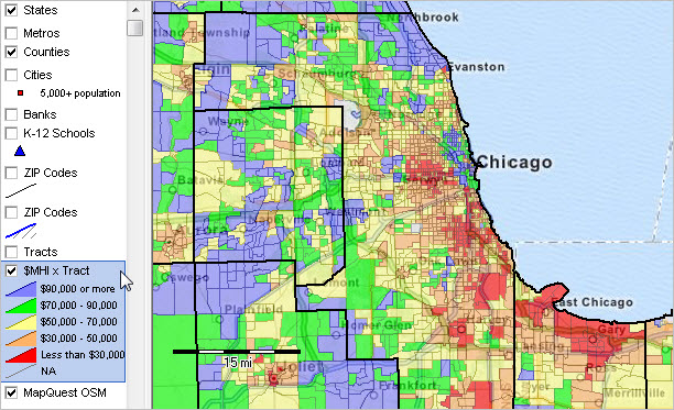
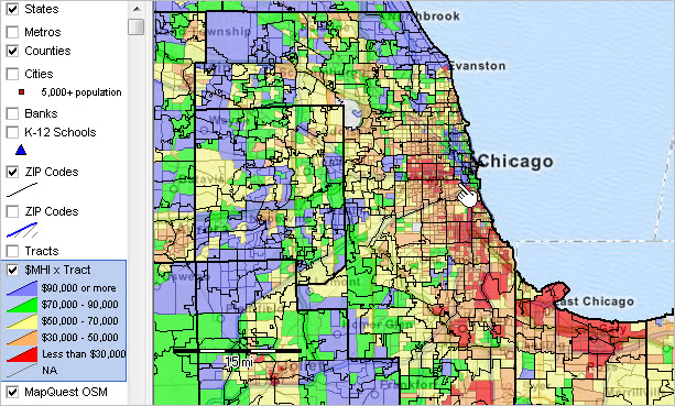
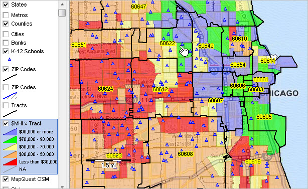
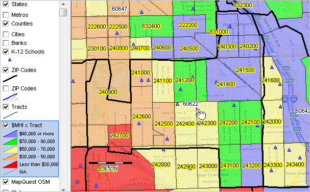
-- demographic patterns by neighborhood A wide range of demographic-economic data for census tracts and ZIP code areas are now developed annually as a part of the American Community Survey (ACS). Census tract and ZIP code area demographics are popular for examining characteristics of sub-county areas. This section reviews use of resources to analyze census tract demographics in context of ZIP code areas. For many analytical and decision-making applications these methods might be preferred to analyzing ZIP code area demographics alone. Census tracts provide a more granular geography than ZIP code areas, have well known boundaries, have little change over the decade and provide a more uniform population size, averaging 4,000 population. Census tracts are more suitable for demographic analysis as compared to ZIP code areas. Yet, users of these data seek to understand patterns by ZIP code areas. This section reviews how that can be done. The applications make use of census tract demographics based on the ACS 2013 5-year estimates. Geographic Information System (GIS) resources are used here. The census tract to ZIP code area relationship can also be be shown in an equivalence table. See the census tract to ZIP Code area interactive equivalence table. While the equivalence table is very useful, use of GIS tools offer a much more powerful method of understanding demographic-economic relationships. These applications are focused on the Chicago area, but the same set of resources can be used anywhere in the U.S. Patterns of Economic Prosperity by Census Tract The graphic presented below shows patterns of the economic prosperity (median household income/MHI) by census tract in the Chicago area. MHI intervals and corresponding colors are shown in the legend at the left of the map. It is easy to see where concentrations of high and low MHI exist by census tract.  Click graphic for larger view; view developed with CV XE GIS. Map view developed using TractZIP GIS Project. Relating ZIP Codes to Census Tracts The graphic presented below shows a view similar to the map shown above. In this view ZIP code areas have been added. ZIP code areas are shown by black boundaries and labeled with the ZIP Code. As above, it is easy to see where concentrations of high and low MHI exist by census tract are located and now -- how the distribution relates to ZIP code areas. Click graphic for larger view that shows ZIP codes as labels.  Click graphic for larger view; view developed with CV XE GIS. Map view developed using TractZIP GIS Project. Neighborhood Drill-Down The graphic presented below shows a zoom-in view in the vicinity of the pointer in the map shown above. ZIP code areas have a bolder black boundary and ZIP codes are shown as labels. K-12 school locations have been added, illustrating how yet other area characteristics can be integrated. The tracts thematic pattern layer is shown with see-through transparency enabling a background view of highways and related earth surface geography.  Relating Tract Codes/Areas to ZIP Codes/ZIP Code Areas The graphic presented below shows a zoom-in view of ZIP code view similar to the map shown above. In this view the focus is placed on ZIP code area 60622 -- it could be any ZIP code. This view shows the ZIP code with white label and census tracts with yellow labels. It is easy to see which census tracts intersect with ZIP code 60622, which tracts are wholly versus partly included in the ZIP code area and the MHI for each tract intersecting ZIP code 60622.  Using the Tract/ZIP GIS Project The Tract/ZIP GIS project can be used to examine small area citizen voting age population Use the Tract/ZIP GIS Project to create your own maps similar to those shown above. 1. Install the ProximityOne CV XE GIS (only required if not already installed) ... run the CV XE GIS installer ... take all defaults during installation 2. Download the Tract/ZIP GIS Project fileset ... requires ProximityOne CV XE GIS Level 2/3 ID ... unzip Tract/ZIP GIS project files to local folder c:\tractzip 3. Open the c:\tractzip\tractzip2.gis project ... after completing the above steps, click File>Open>Dialog ... open the file named c:\tractzip\tractzip2.gis 4. Done. Start-up view appears. Support Using these Resources Learn more about demographic economic data and related analytical tools. Join us in a Decision-Making Information Web session. There is no fee for these Web sessions. Each informal session is focused on a specific topic. The open structure also provides for Q&A and discussion of application issues of interest to participants. ProximityOne User Group Join the ProximityOne User Group to keep up-to-date with new developments relating to geographic-demographic-economic decision-making information resources. Receive updates and access to tools and resources available only to members. Use this form to join the User Group. There is no fee. Additional Information ProximityOne develops geographic-demographic-economic data and analytical tools and helps organizations knit together and use diverse data in a decision-making and analytical framework. We develop custom demographic/economic estimates and projections, develop geographic and geocoded address files, and assist with impact and geospatial analyses. Wide-ranging organizations use our software, data and methodologies to analyze their own data integrated with other data. Follow ProximityOne on Twitter at www.twitter.com/proximityone. Contact ProximityOne (888-364-7656) with questions about data covered in this section or to discuss custom estimates, projections or analyses for your areas of interest. |
|
|