
|
|
|
Urban Area Demographic Trends 2010-15 -- Urban Areas in Context of Metropolitan Areas
January 2017. The four fastest growing Urbanized Areas (UAs) from 2010 to 2015 were in Texas. McKinney, TX UA led the nation with an increase of 27.5% in total population. View, rank, compare 2010 and 2015 demographic characteristics for UAs using the interactive table below. Urban areas (Urbanized Areas and Urban Clusters) are important for many reasons. More than metros and cities, urban area geography better reflects how the urban and rural population is changing. Both metros and cities can change geographic boundary over the years. Urban areas are based on Census 2010 and unchanging between 2010 and 2020. Annual demographic updates are available from the American Community Survey (ACS 2015). U.S. Urban & Rural Population; 2010-2015
This section is focused on tools and analytics to examine all urban areas with particular focus on Urbanized Areas and demographic change between 2010 and 2015. Use the interactive table in this section to view, rank, query urban areas and demographic change for larger urban areas. Use the related GIS tools and data to develop related thematic and relationship maps. Perform geospatial analysis of geographic and demographic-economic characteristics using the resources we have developed. Gain insights into patterns that might affect you. Use these resources to collaborate on how, where, what, when and why of change. McKinney TX Urbanized Area in Context of City The McKinney, TX UA (bold orange pattern) is shown in context of McKinney city (cross-hatched area) and other urban areas (lighter orange pattern). It is easy to see that some parts of the city are rural and that the UA extends beyond the city in many areas. See more about the McKinney UA and in comparison to other urban areas using the interactive table below.  - view created using CVGIS software and related GIS project. Most Urbanized Areas (UAs, 435 of 487) have population 65,000 population or more resulting in the availability of annual demographic-economic estimates. Data are fresher than available for smaller urban areas (ACS 5-year estimates for areas under 65,000). This means more current data to assess more recent characteristics. As annual data are available UAs enabling analysis of change over time. The "2010s" marks the first time these refreshed, time series-like data have been available for urban areas. Businesses and those examining change performing market analysis benefit from the ability to examine characteristics or urban areas in combination with counties and metros. Houston Urbanized Area in Context of Houston Metro The Houston metro has a bold brown boundary. It is easy to see how the Houston UA (darker orange fill pattern) geographically relates to the metro. Other urban areas (all) are shown with a lighter orange fill pattern. It is easy to see the urban/pattern character of the general region. While the Houston UA is the largest, there are four UAs that intersect with Houston metro. Use the interactive table below to view their names and characteristics. 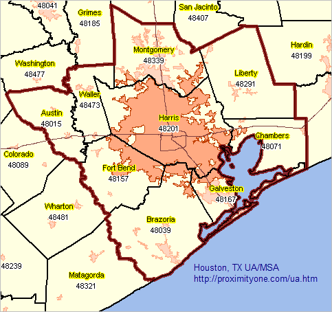 - view created using CVGIS software and related GIS project. Urbanized Areas tend to be associated with metropolitan areas having a similar name. But very often there are multiple UAs within a metro; sometimes one is not dominant. Often there are several UAs in a metro having similar size. Use the interactive table below to view the relationship of UAs and metros (CBSAs). Use the interactive table to view, query, rank, compare selected characteristics of all urban areas. Urban Area Demographic Characteristics 2010-2015 -- interactive table All Census 2010 urban areas are shown in this table. Click column header to sort; click again to sort other direction. See usage notes below table. See related interactive tables Usage Notes • Click ShowAll button between specific queries. • Negative values (and 0 values in Pop 2015) indicate this data item not available. • "UA Pop10 in Metro" differs from "Population 2010" only where the UA extends beyond the corresponding metro boundary. • Name/Code column: area name followed by state abbreviation and UA code • Click UrbanType to select only Urbanized Area or only Urban Cluster. Click Find UA to filter table on UA Name column (case sensitive; uses partial/exact values). Click Find Metro to filter table on Metro Name column (case sensitive; uses partial/exact values). • Click Pop Chg Cols to view Population Change columns. Items/Column Headers • Urban Area (UA) Name • State • Urban Area Census 2010 Code • Urban Area Type U:Urbanized Area, C:Urban Cluster • Metro/CBSA Name 2015 containing this UA • Metro/CBSA Code 2015 containing this UA • Urban Area Census 2010 Population part of corresponding metro • Urban Area Census 2010 Population as percent of Metro • UACensus 2010 Population • UA Census 2010 Housing Units • UA Land Area SqMi 2010 • UA Water Area SqMi 2010 • UA Population Density 2010 • UA Population 2015 (ACS 1 year estimate) • UA Population Change 2010-2015, as available • UA % Population Change 2010-2015, as available Urban Clusters Most of this section is about Urbanized Areas. The following graphics show examples of Urban Clusters (orange fill pattern) in context of the corresponding city boundaries (grey cross-hatch pattern). Both views illustrate how rural areas can exist within the city boundary and how urban areas can exist outside the city boundary. Legally defined city boundaries can update annually. City boundaries shown here are as of January 2016. Indianola, IA City and Urban Cluster 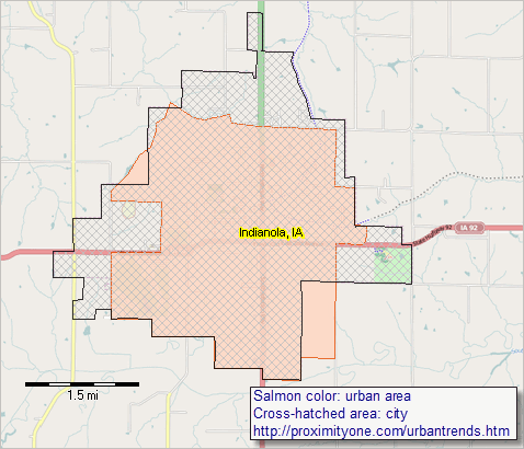 - view created using CVGIS software and related GIS project. Nevada, MO City and Urban Cluster 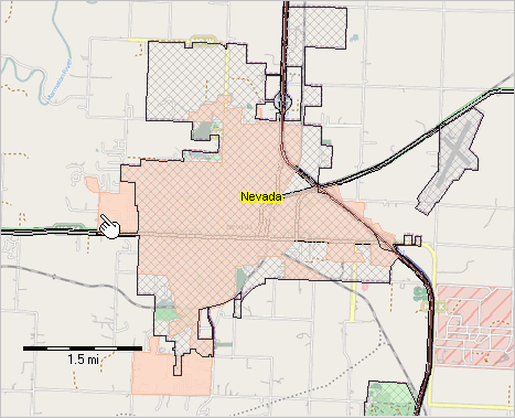 - view created using CVGIS software and related GIS project. Iola, KS City and Urban Cluster 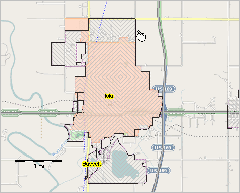 - view created using CVGIS software and related GIS project. Urban-Rural Geographic Classifications The urban-rural geographic classification identifies individual urban areas and rural areas. Urban areas are densely developed territory, and encompass residential, commercial, and other non-residential urban land uses. Rural areas encompass all population, housing, and territory not included within an urban area. The most recent urban-rural geographic classification is based on Census 2010. An urban area is a densely settled core of census tracts and/or census blocks that meet minimum population density requirements, along with adjacent territory containing non-residential urban land uses as well as territory with low population density included to link outlying densely settled territory with the densely settled core. To qualify as an urban area, the territory identified according to criteria must encompass at least 2,500 people, at least 1,500 of which reside outside institutional group quarters. There are two types of urban areas: • Urbanized Areas (UAs) of 50,000 or more people .. there are 486 Census 2010-based UAs .. Census 2010 population in UAs: 219,922,123 • Urban Clusters (UCs) of at least 2,500 and less than 50,000 people .. there are 3,087 Census 2010-based UCs .. Census 2010 population in UCs: 29,331,148 • Total Census 2010 U.S. population: 308,745,538 .. total Census 2010 urban population: 249,253,271 (80.7%) .. total Census 2010 rural population: 59,492,276 (19.3%) While cities and census designated places may have an urban character, these areas, like metropolitan areas, often contain rural geography within their boundaries. Likewise, urban areas associated with a city, place or metro may extend outside of that boundary. ProximityOne User Group Join the ProximityOne User Group to keep up-to-date with new developments relating to metros and component geography decision-making information resources. Receive updates and access to tools and resources available only to members. Use this form to join the User Group. Support Using these Resources Learn more about accessing and using demographic-economic data and related analytical tools. Join us in a Data Analytics Lab session. There is no fee for these one-hour Web sessions. Each informal session is focused on a specific topic. The open structure also provides for Q&A and discussion of application issues of interest to participants. Additional Information ProximityOne develops geodemographic-economic data and analytical tools and helps organizations knit together and use diverse data in a decision-making and analytical framework. We develop custom demographic/economic estimates and projections, develop geographic and geocoded address files, and assist with impact and geospatial analyses. Wide-ranging organizations use our tools (software, data, methodologies) to analyze their own data integrated with other data. Follow ProximityOne on Twitter at www.twitter.com/proximityone. Contact us (888-364-7656) with questions about data covered in this section or to discuss custom estimates, projections or analyses for your areas of interest. |
|
|