
|
|
|
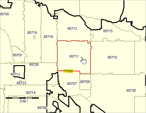
-- tools & data to examine ZIP code/place geodemographics .. 214 ZIP code areas intersect with New York city -- what are these ZIP codes, their population and how many are completely within the city? What part of a ZIP code area of interest intersects with what city? Conversely, what ZIP code areas intersect with a city of interest? This section provides data and tools that can be used to answer these types of questions and gain insights into geospatial relationships. The 2010 ZIP Code Tabulation Area (ZCTA) to City/Place relationship data provide a means to equivalence ZCTAs with Census 2010 cities/places. ZCTAs are geographic areas defined as sets of Census 2010 census blocks closely resembling USPS ZIP codes (lines, not areas). ZCTA boundaries are fixed for the intercensal period 2010 through 2020. Census 2010 vintage city/place areas are likewise defined as sets of Census 2010 census blocks. The ZCTA-City/place relationship data are developed through the use of the intersecting census block geography and associated Census 2010 Summary File 1 demographic data. ZCTA-Place Relationships The following graphic shows relationships between two selected ZCTAs (red boundaries) and related cities/places (blue fill pattern) in the Pima/Cochise County, AZ area. Relationships between these geographies are reviewed in examples shown below. 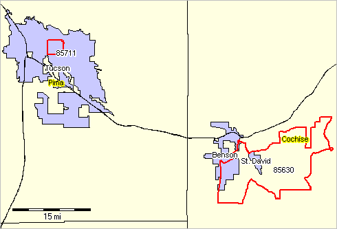 - View developed using CV XE GIS and related GIS project. Using the ZCTA-Place Relationship Data Two examples illustrating how to use the ZCTA-place relationship data are provided below. The examples are interconnected to the GIS project used to develop the map views, interactive table and data file described in this section. Example 1 describes how to use the data for a ZIP code area entirely located within one city/place. Example 2 describes how to use the data for a ZIP code area located in more than one city/place and area not located in any city/place. ZIP Code Area - City/Place Relationship interactive table Click column header to sort; again to sort other direction. Click ShowAll button between queries to refresh. Usage notes below table. See related interactive tables Usage Notes • Click ShowAll between queries/filters. • Use left-most column to select by state. • Find in Place Name button; click ShowAll button first .. click Find in Name button to search place name column for text in edit box. .. text entered in edit box is case sensitive. .. partial names are okay to use. .. click with default value to view all rows with "Tucson" (no quotes) .. used in example 1 below. • Find in ZIP button; click ShowAll button first .. click Find in ZIP button to search column 1 for text in edit box. .. text entered in edit box must be the 5-character ZIP code. .. click with default value to view all rows with "85630" (no quotes) .. used in example 2 below. • Find in StCode button; click ShowAll button first .. click Find in StCode button to search column 4 for text in edit box. .. text entered in edit box must be the 7-character State+Place code. .. click with default value to view all rows with "0477000" (no quotes) .. note that using Find in Place Name with Tucson yields 33 intersecting ZIPs, some not in Tucson, AZ. by using the StPlace code, there is an exact match to Tucson, AZ -- 29 ZIP codes. ZCTA to Place Relationships: Example 1 [goto top] Using GIS data and tools, this application makes use of queries applied to layers so that only selected ZCTAs and cities/places are shown. Use this GIS project to develop similar views for any area in the U.S. In this example, ZCTA 85711, highlighted in red in the graphic shown below, falls wholly within place 77000, outlined in bold black below. Therefore, there is only one corresponding record for ZCTA 85711 in the relationship file. The 2010 Census population for this relationship record is 41,251 (POPPT) which is equal to the 2010 Census population for ZCTA 85711 (ZPOP). However, the population for this relationship record (POPPT) does not equal the 2010 Census population total for place 77000 of 520,116 (PLPOP) because the place is much bigger and contains many ZCTAs. Therefore, while the percentage of people living within ZCTA 85711 and also in place 77000 is 100 (ZPOPPCT), the percentage living within the place 77000 and also in the ZCTA 85711 is 7.93 (PLPOPPCT). In addition, the total number of housing units within this relationship record (HUPT) is 19,649. This equals the number of housing units in ZCTA 85711 (ZHU), but that only represents 8.55% of the total housing units within place 77000 (PLHUPCT).
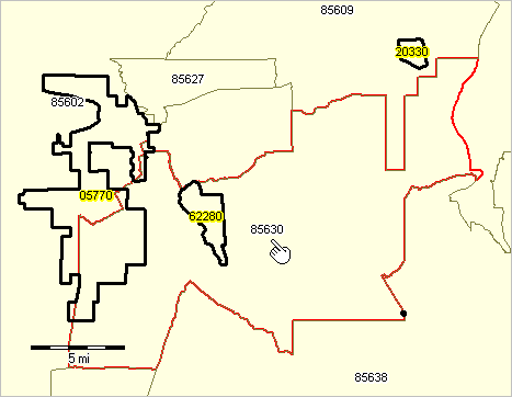
 - View developed using CV XE GIS and related GIS project. ZCTA to Place Relationships: Example 2 [goto top] Using GIS data and tools, this application makes use of queries applied to layers so that only selected ZCTAs and cities/places are shown. Use this GIS project to develop similar views for any area in the U.S. In this example, ZCTA 85630, highlighted below in red in the graphic shown below, contains two places: all of place 62280 and part of place 05770, both are outlined in black below. Therefore, there are two corresponding relationship records in the relationship file. For the first relationship record, the total 2010 Census population for ZCTA is 2,819 (ZPOP). However, out of the total population living within the ZCTA, only 1,699 also live within place 62280 (POPPT) and this accounts for 60.27% of the total population of ZCTA 85630 (ZPOPPCT) and 100% of the total population of place 62280 (PLPOPPCT). Likewise, for relationship record 2, out of the total population living with ZCTA 85630, only 3 also live within that part of place 05770 that overlays ZCTA 85630 (POPPT) and this represents 0.11% of the population in the ZCTA (ZPOPPCT) and 0.06% of the population in Place 05770 (PLPOPPCT). It is important to note that because part of ZCTA 85630 is not covered by a place, and therefore not included in the relationship file, the population and housing unit values for each record will not equal the total for the ZCTA.
 - View developed using CV XE GIS and related GIS project. ZCTA-PLACE Dataset [goto top] - Click here to download the zcta_place.zip dataset (dbf structure; userid required) - fees may apply Items in File/Table
Terms of Use [goto top] Information, data, tools provided in this section and/or links to data and tools provided via this section are: • for personal use only. • may not be redistributed whole or in part. There is no warranty of any type associated with any aspect of information, data, tools provided in this section. The user of these resources is solely responsible to any use, direct or indirect, that might be made of these resources. Support Using these Resources [goto top] Learn more about demographic economic data and related analytical tools. Join us in a Data Analytics Lab session. There is no fee for these Web sessions. Each informal session is focused on a specific topic. The open structure also provides for Q&A and discussion of application issues of interest to participants. ProximityOne User Group [goto top] Join the ProximityOne User Group to keep up-to-date with new developments relating to geographic-demographic-economic decision-making information resources. Receive updates and access to tools and resources available only to members. Use this form to join the User Group. Additional Information ProximityOne develops geodemographic-economic data and analytical tools and helps organizations knit together and use diverse data in a decision-making and analytical framework. We develop custom demographic/economic estimates and projections, develop geographic and geocoded address files, and assist with impact and geospatial analyses. Wide-ranging organizations use our tools (software, data, methodologies) to analyze their own data integrated with other data. Follow ProximityOne on Twitter at www.twitter.com/proximityone. Contact us (888-364-7656) with questions about data covered in this section or to discuss custom estimates, projections or analyses for your areas of interest. |
|
|