
|
|
|
October 2022 .. examining county and regional income and poverty trends .. the 2020 county poverty rate ranged from Douglas County, CO (3.0%) and Loudoun County, VA (3.2%) to Mitchell County, GA (42.5%) and Oglala Lakota County, SD (39.6%). These data are based on Census Bureau sourced annual model-based estimates. We have developed an annual time series of those data from 2010 through 2020. This section updates with 2021 estimates in December 2022. The official poverty rate in 2021 was 11.6 percent, with 37.9 million people in poverty. Neither the rate nor the number in poverty was significantly different from 2020. Poverty Mitigation Our focus is on using these data, and variations of these data, to identify and apply tools to mitigate poverty. A first step is understanding how poverty manifests itself for a small area geography, such as counties. A second step is to organize a time series of poverty estimates that can be analyzed using a model. By examining cause and effect relationships, we then seek to project/forecast poverty incidence into the future under alternative scenarios. The alternative scenarios reflect different assumptions and policy tools. By knowing more about expected outcomes in 2030, we might better know what tools, methods work to mitigate poverty by county/region. Examining different small area geographic granularity, such as census tracts, might be a next step. Here the focus is on counties and tools that can be used to examine income and poverty, over time, in context of other wide-ranging geography and subject matter. The county income and poverty dataset used in this section has been developed using the Demographic Economic Data Explorer DEDE. See list of subject matter fields below. DEDE can also be used to examine these data as a part of the Situation & Outlook (S&O). See this illustrative section in the Fresno County S&O report. Patterns of Poverty Rate, All Ages, 2020, by County 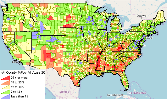 Accessing/Analyzing Income & Poverty using VDA Web GIS Use the VDA Web GIS with the MetroDynamics project to use the County Income and Poverty layer/data. VDA Web GIS is developed and maintained by Warren Glimpse/ProximityOne/Alexandria, VA USA and Takashi Hamilton/Tsukasa/Osaka, Japan. Using VDA Web GIS: Patterns of Poverty Rate, All Ages, 2020, by County The graphic shown below, developed using VDA Web GIS with the MetroDynamics project, is similar to the above view. It illustrates use of the table feature to show/examine counties as rows with selected poverty related attributes. Counties are ranked in descending order based on the 2020 poverty rate rightmost column (POVR20). Compare the 2010 poverty rate to the 2020 (or other) annual rate. Selected other age groups or related demographics. 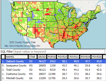 Subject Matter Items The record layout for the county poverty dataset created by DEDE is shown below. A standardized set of income and poverty-related fields is repeated for each year, 2010 through 2020/2021.
NAME .. area name
STAB .. state USPS abbreviation GEOID .. state+conty FIPS code -- 2010 -- MHI10 Median Household Income POV017E10 Population age 0-17 in poverty, 2010 POV017R10 Population age 0-17 poverty rate, 2010 POV017U10 Population age 0-17 poverty universe, 2010 POV517E10 Population age 5-17 in poverty, 2010 POV517R10 Population age 5-17 poverty ratev POV517U10 Population age 5-17 poverty universe, 2010 POVE10 Population all ages in poverty, 2010 POVR10 Population all ages poverty rate, 2010 POVU10 Population all ages poverty universe, 2010 -- 2011 -- MHI11 POV017E11 POV017R11 POV017U11 POV517E11 POV517R11 POV517U11 POVE11 POVR11 POVU11 -- 2012 -- MHI12 POV017E12 POV017R12 POV017U12 POV517E12 POV517R12 POV517U12 POVE12 POVR12 POVU12 -- 2013 -- MHI13 POV017E13 POV017R13 POV017U13 POV517E13 POV517R13 POV517U13 POVE13 POVR13 POVU13 -- 2014 -- MHI14 POV017E14 POV017R14 POV017U14 POV517E14 POV517R14 POV517U14 POVE14 POVR14 POVU14 -- 2015 -- MHI15 POV017E15 POV017R15 POV017U15 POV517E15 POV517R15 POV517U15 POVE15 POVR15 POVU15 -- 2016 -- MHI16 POV017E16 POV017R16 POV017U16 POV517E16 POV517R16 POV517U16 POVE16 POVR16 POVU16 -- 2017 -- MHI17 POV017E17 POV017R17 POV017U17 POV517E17 POV517R17 POV517U17 POVE17 POVR17 POVU17 -- 2018 -- MHI18 POV017E18 POV017R18 POV017U18 POV517E18 POV517R18 POV517U18 POVE18 POVR18 POVU18 -- 2019 -- MHI19 POV017E19 POV017R19 POV017U19 POV517E19 POV517R19 POV517U19 POVE19 POVR19 POVU19 -- 2020 -- MHI20 POV017E20 POV017R20 POV017U20 POV517E20 POV517R20 POV517U20 POVE20 POVR20 POVU20 -- 2021 -- coming in December 2022 MHI21 POV017E21 POV017R21 POV017U21 POV517E21 POV517R21 POV517U21 POVE21 POVR21 POVU21 Related database details. More in general, not all county codes/areas are constant over time or annually. The dataset is initially developed based on the 2020 counties and codes. Prior year data is integrated into these records. Where there is no matching prior year code (mainly Alaska) those fields are not populated (show zero value). ProximityOne User Group Join the ProximityOne User Group to keep up-to-date with new developments relating to metros and component geography decision-making information resources. Receive updates and access to tools and resources available only to members. Use this form to join the User Group. Support Using these Resources Learn more about accessing and using demographic-economic data and related analytical tools. Join us in a Data Analytics Lab session. There is no fee for these one-hour Web sessions. Each informal session is focused on a specific topic. The open structure also provides for Q&A and discussion of application issues of interest to participants. Additional Information ProximityOne develops geographic-demographic-economic data and analytical tools and helps organizations knit together and use diverse data in a decision-making and analytical framework. We develop custom demographic/economic estimates and projections, develop geographic and geocoded address files, and assist with impact and geospatial analyses. Wide-ranging organizations use our tools (software, data, methodologies) to analyze their own data integrated with other data. Follow ProximityOne on Twitter at www.twitter.com/proximityone. Contact ProximityOne (888-364-7656) with questions about data covered in this section or to discuss custom estimates, projections or analyses for your areas of interest. |
|
|
