
|
|
|
Workforce Analysis Solutions -- accessing & integrating EEO ACS 2014-18 into your planning & operations
March 2021 .. the future of work .. remote work is here to stay. This change creates new challenges and opportunities. A silver lining in the pandemic, we are entering a new era. It is helpful to know about where we have been, and how things are changing, to know where we are going. This section is focused on accessing and using the Equal Employment Opportunity (EEO) American Community Survey 2014-2018 (ACS EEO 2018) special tabulation data. The ACS EEO data are a primary resource for comparing the race, ethnicity, and sex composition of an organization's internal workforce, to the analogous external labor market, within a specified geography and occupation. It includes data on other demographic and economic characteristics. It is used by organizations to develop and update affirmative action plans. Developed by the Census Bureau, ProximityOne provides augmented related resources and tools to access, integrate and use these data with other data. In this section: • 01 Interactive table -- view, query, compare county data • 02 Using the Workforce integrated software & database • 03 Workforce GIS resources & geospatial analysis • 04 Related Workforce data resources The ACS EEO 2018 special tabulation includes population estimates by race, ethnicity and sex composition of the workforce for specified occupations and geographies. Occupation data are provided in Detailed Census Occupations, and in 4 aggregations: EEO Occupational Groups, EEO-1 Job Categories, Federal Sector Job Groups, and State and Local Government Job Groups. Other subject matter characteristics include U.S. citizenship, educational attainment, age, industry, earnings, and unemployment status. The EEO provides information at three geographic types - worksite, residence-to-worksite commuting flows, and residence. See about what you can do with these data. Patterns of Biological Scientist Employment by County/Worksite, Atlanta Metro Biological scientists are one of 236 occupational categories for which ACS EEO data are tabulated. The following graphic shows counties (blue fill pattern) for which data are available from the EEO ACS 2014-18 special tab in this region (see broader U.S. view below). The number of employed Asian non-Hispanic biomedical scientists by worksite is shown with a white label. The total number of employed biomedical scientists by county is shown a yellow label. For counties with no label, the estimated number of employed biomedical scientists by worksite is zero.  - developed using ProximityOne CV XE GIS software and related GIS project See this spreadsheet view comparing attributes of Fulton & DeKalb Counties. - this spreadsheet graphic was generated using the CV XE GIS software to generate side-by-side comparison profiles. - the content of the profile is based on the county shapefile containing the integrated ACS EEO items for total employment, upper rows/fields, and biological scientist employment, lower rows/fields. - this view shows how the application can generate similar views for any set of geography/occupation by race/origin Relating Workforce Areas to ACS EEO Tabulation Geography .. goto top A business employment recruitment area might relate to one county or an area much larger. While the ACS EEO special tabulation data are available for many indivdiual larger counties, the county is the low level geographio tabulation unit. Data for most counties are available for grouped county areas .. "County Set 50". The map graphic presented below illustates this relationship. The interactive table below provides data for all counties. and shows the corresponding county set name/code and related data. Illustrative Profile The following graphic shows a partial profile for a subset of the data in the ACS EEO special tabulation Table "1W" for Los Angeles County, CA. Click the graphic to view the full profile (an XLS file). This profile/report shows a row for each each of 236 occupational categories included in the special tabulation. Across the columns the ACS 2014-18 estimated total employment is shown for each of these categories: total, Hispanic (of any race), White alone non-Hispanic, Black alone non-Hispanic, American Indian/Alaska Native alone non-Hispanic, Asian alone non-Hispanic, Native Hawaii & Other Pacific Islander alone non-Hispanic, and remainder non-Hispanic. The graphic is partial in that it only shows the "upper section" of the full profile. The XLS file includes all occupationsl levels. 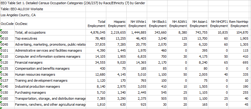
Visual Analysis of EEO ACS 2014-18 Geography The following graphic shows counties (blue fill pattern) for which data are available from the EEO ACS 2014-18 special tab. Click graphic for larger view. Expand browser window to full screen for best quality view. 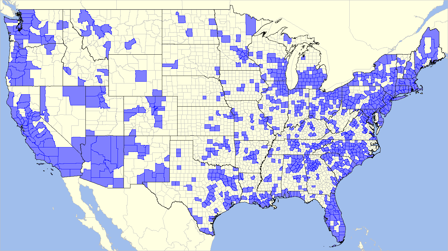 - developed using ProximityOne CV XE GIS software and related GIS project The next graphic illustrates relationships among county, county-set and metro geography. This view is focused on Kansas and illustrates "county set" tabulation area geography used in the ACS special tabulations. Counties are shown with gray boundaries, "County set 50 areas" (CS50) with bolder boundaries. Metros (MSAs) are shown with green fill pattern. Click graphic for larger view that illustrates use of CS50 codes. Expand browser window to full screen for best quality view. 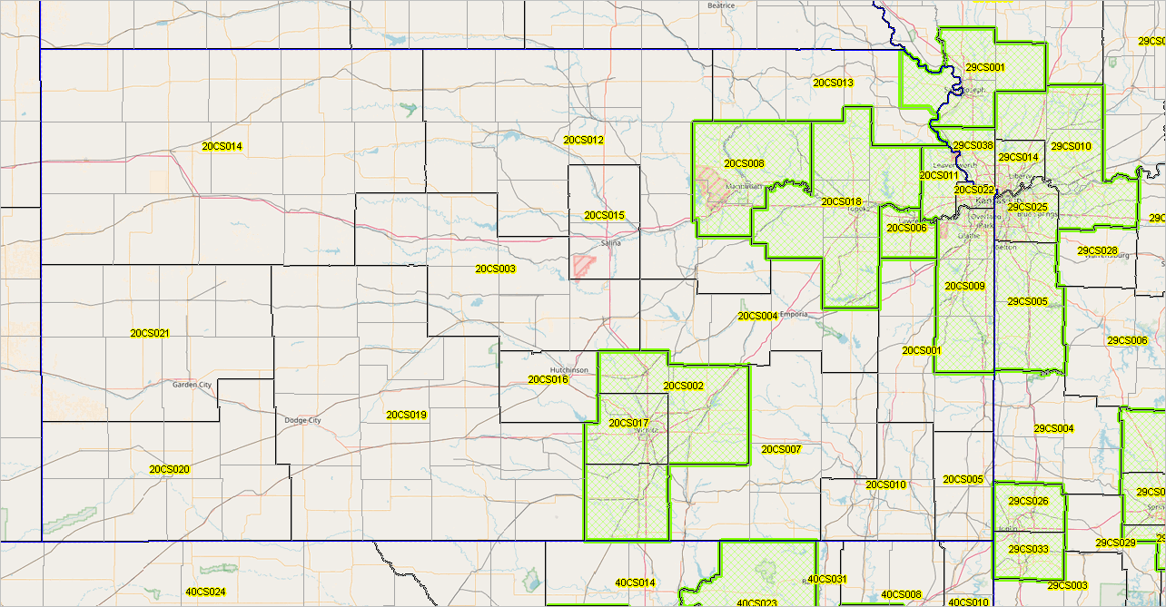 - developed using ProximityOne CV XE GIS software and related GIS project EEO ACS 2018 County Selected Characteristics .. Interractive Table .. goto top Table 1W data. Population: by place of residence; Employment: by place of work; -1 values: data not available Click column header to sort; click again to sort other direction. Click ShowAll between queries. See related Interactive Tables Main Page Using the Interactive Table This table includes all 3,142 U.S. counties; 983 of these counties are included in the EEO ACS 2018 special tab. The value -1 appears in the the EEO ACS 2018 special tab columns for counties where no data was tabulated for individual counties (under the 50,000 population cut-off. .. click ShowAll button then CtyAlone button to view only these counties. Data from other statistical programs are included in the leftmost columns. Click ShowAll button between queries. Using GIS & Workforce Analysis .. goto top ProximityOne has developed a set of shapefiles that enable the user to view all of the ACS EEO geographies flexibly using GIS tools. We have assembled/integrated these geographies into a ready-to-use GIS project with the CV XE GIS software. These shapefiles are represented as layers (states, metros, counties, county sets, places) in a GIS project. This is a much better, more flexible, solution than using more limiting PDF maps or Web GIS operations. Apply queries of layers to view geographies meeting certain criteria. Add attibutes to the shapefiles to show geographies of special interest. Flexibly color/label layers to depict selected geographies and relationships among geographies. Add your own shapefiles with your own geographies. Add your own subject matter data or codes. The ACS EEO special tabulation data are restuctured into a database structure enabling users to integrate the data into shapefiles for reference mapping as well as thematic/pattern mapping and geospatial analysis. Examine selected occupations or occupational groupings of interest. Related Workforce Data Resources .. goto top .. under development ...
Using ACS PUMS Data
The annually released ACS Public Use Microdata Sample (PUMS) offer a related, companion data resource that can supplement use of the ACS EEO special tabulation. For example, using the PUMS data, users can develop custom estimates for the same or more detailed subject matter contained in the ACS EEO special tabulation for Public Use Microdata Areas (PUMA) geography. In the case of Los Angeles county this means that data similar to the ACS EEO data can be estimated for 69 PUMAs (covering the county wall-to-wall) whereas the ACS EEO small area geography is the entire county. Using ACS Summary Data File The ACS summary data file contains the preplanned summary statistics which are generally much broader subject matter that the detail provided in the ACS EEO special tabulation. Yet these data will be of use to most all users of the ACS EEO data, See the section on ACS 2014-18 5-year estimates. While the small area geography for the ACS EEO tabulation is county, the ACS summary file data are available to the block group level of geography (wall-to-wall U.S. coverage). Optionally, access those data using the API. The ACS EEO data provide data for 276 occupational categories where the ACS summary file data include only 73 occupational categories. While the ACS summary file provides data for those 73 occupational groups by race/ethnicity, the specific race/ethnicity categories used for the ACS EEO tabulation are not available in the ACS summary file. BLS .. Detailed industry occupation projections .. Detailed occupational data from Current Population Survey .. Occupational Employment Statistics Related Federal Statistical Data Resources .. under development ... About the ACS 2014-18 EEO Special Tabulation .. goto top The EEO special tabulation is a custom product developed by the Census Bureau to meet the needs of four Federal agencies, consisting of the Equal Employment Opportunity Commission (EEOC), the Department of Justice (DOJ), the Department of Labor (DOL), and the Office of Personnel Management (OPM). This tabulation was created according to the specifications of the agencies in the consortium working with the Censu Bureau. The EEOC and other agencies use these data, and require employers to make use of these data, in the operation of affirmative action/equal employment opportunity programs. Businesses and organizations which operate affirmative action programs use these data to prepare workforce characteristics reports, make employment decisions and establish goals. These data play an important role in employment discrimination litigation by all parties. Workforce Software & Integrated Database .. goto top The ProximityOne Workforce can be installed and used on a Windows computer. To install the application, proceed as follows: • Run the Workforce installer. .. requires UserID and password .. taking all default settings recommended. • The installer places with Workforce software, related files and the EEOALL1W_P01 data on your computer. • The Workforce application starts immediately and can be subsequently started using the desktop icon. • The startup view appears as follows: 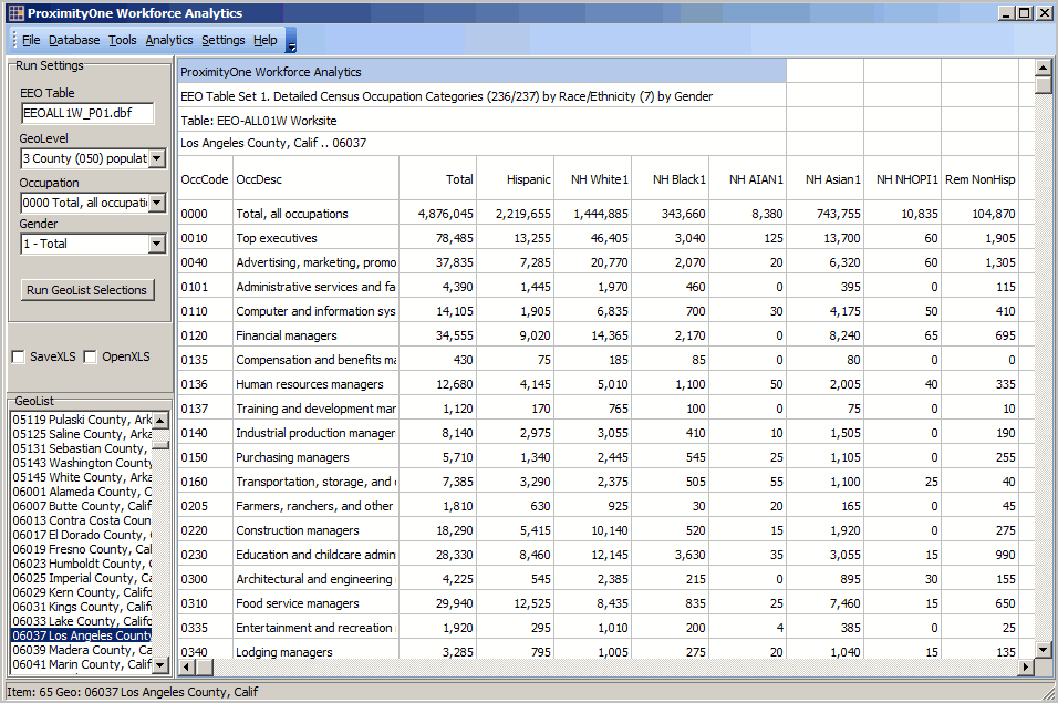
Using the Workforce County EEOALL1W_P01 Application • This version uses only the national all county, prereloaded, EEOALL1W_P01 data • All counties shown in GeoList listbox, lower left. Dbl-Click any county to show profile in grid. • Check two checkboxes above GeoList listbox to auto open XLS version of grid. • Optionally multi-select areas from GelList listbox then click Run from GeoList button. • Profile structure: .. each row corresponds to an occupation; automatically includes all occupations. .. each column corresponds to a population group: - Total employed - Hispanic (of any race) employed - White alone non-Hispanic employed - Black alone non-Hispanic employed - American Indian/Alaska Native alone non-Hispanic employed - Asian alone non-Hispanic employed - Native Hawaii & Other Pacific Islander alone non-Hispanic employed - Remainder non-Hispanic employed Additional Information ProximityOne develops geographic-demographic-economic data and analytical tools and helps organizations knit together and use diverse data in a decision-making and analytical framework. We develop custom demographic/economic estimates and projections, develop geographic and geocoded address files, and assist with impact and geospatial analyses. Wide-ranging organizations use our tools (software, data, methodologies) to analyze their own data integrated with other data. Follow ProximityOne on Twitter at www.twitter.com/proximityone. Contact ProximityOne (888-364-7656) with questions about data covered in this section or to discuss custom estimates, projections or analyses for your areas of interest. |
|
|