
|
|
|
What $100 Buys by State & Metro by Type of Item
.. data and tools to examine the purchasing power of the incomes in different metros and states ... this section provides access to data on what $100 buys by state and metro. Examine patterns of what $100 buys by year, 2008-2014, for all items and by type of goods & services category. Varying prices by region can be normalized using Regional Price Parities (RPP). The RPP is a weighted average of the price level of goods and services for the average consumer in one geographic region compared to all other regions in the U.S. See more about RPP measures. Using the RPP data, what $100 will buy can be determined by state and metro for the categories of all goods and services, goods, services-rents and other services. See about RPP goods and services types. In the Boston metro, $100 buys about 90.7 percent of all items goods and services due to the high prices there. $100 in Boston seems more like $90.70 compared to the national average. In the Jefferson City, MO metro, the opposite is true. $100 buys all items goods and services due to lower prices in that metro. $100 in the Jefferson City, MO metro is the equivalent of $121.65 of all items goods and services compared to the national price levels. • the 2014 Boston metro all items buying power index is 90.70 • the 2014 Jefferson City, MO metro all items buying power index is 121.65 Tools to examine the Buying Power Index • Use the interactive table below to view, rank, compare what $100 buys .. for all states and metropolitan statistical areas (MSAs). • Use GIS tools to examine buying power thematic pattern maps. .. add your own data & geography, select different HPI measures or criteria. .. zoom to different geographic extents, label and modify colors as desired. What $100 Buys by Metro: 2014 The following graphic shows patterns of 2014 all items buying power of $100 by metro (MSAs). The color patterns/intervals are shown in the inset legend. Click graphic for larger view. Expand browser to full window for best quality view. Use GIS tools to develop thematic pattern maps for a range of data and criteria. 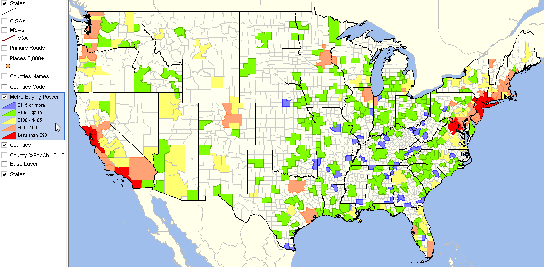 .. view developed using the CV XE GIS software. .. click map for larger view and details. What $100 Buys by State & Metro by Type of Item: 2008-2014 -- interactive table Use mouse-over on header column to view extended item/column name. Click ShowAll button between Find/Queries. See usage notes below table. See related interactive tables. Usage Notes Table structure/content • The leftmost 5 columns describe the geography and types of goods and services. .. there are four rows for each geographic area corresponding to type of goods & services item. • The next seven columns show what $100 bought in this year relative to U.S. national prices. • The next four columns shows how the $100 purchasing power has changed. Types of Goods and Services (Type dropdown selector below table) • All items -- all the detailed consumption goods and services used in the estimation of the RPPs. • Goods -- durable and nondurable consumption goods used in the estimation of the RPPs. .. includes apparel, education, food, housing, medical, recreation, transportation, and other goods. • Services: Rents -- tenants' rents • Services: Other -- services consumption items, except rents .. education, food, housing, medical, recreation, transportation and other services. Table operations • Use mouse-over on header column to view extended item/column name. • Click ShowAll button to reset table. • Find in Name: Key in text/area name (partial okay) in text box to right of Find-in-Name button. .. then click Find-in-Name button to locate all matches in Name column (case sensitive). • ChgCols -- click this button to view change columns. • AllCols -- Click this button to view all columns. • Click ShowAll button between queries Column Descriptions - Area name - St -- state USPS abbreviation - GeoID -- state FIPS code or CBSA code - Goods & Services Type - Goods & Services Type Description - What $100 bought in 2008 relative to national level - What $100 bought in 2009 relative to national level - What $100 bought in 2010 relative to national level - What $100 bought in 2011 relative to national level - What $100 bought in 2012 relative to national level - What $100 bought in 2013 relative to national level - What $100 bought in 2014 relative to national level - What $100 bought -- Change 2013-14 - What $100 bought -- Percent Change 2013-2014 - What $100 bought -- Change 2010-2014 - What $100 bought -- Percent Change 2010-2014 About Regional Price Parities and Implicit Regional Price Deflators Regional Price Parity estimates for states and metropolitan statistical areas have been developed for the period 2008-2014, annually by the Bureau of Economic Analysis (BEA). The estimates are updated/extended annually. The next update will be July 2017. Price indexes commonly measure price changes over time. The BEA Personal Consumption Expenditure (PCE) price index and the BLS Consumer Price Index (CPI) are two examples. Spatial price indexes measure price level differences across regions for one time period. An example of these type of indexes are purchasing power parities (PPPs), which measure differences in price levels across countries for a given period, and can be used to convert estimates of per capita GDP into comparable levels in a common currency. The regional price parities (RPPs) that BEA has developed compare regions within the United States, but without the need for currency conversion. An implicit regional price deflator (IRPD) can be derived by combining the RPPs and the U.S. PCE price index. Regional Price Parities. The RPPs are calculated using price quotes for a wide array of items from the CPI, which are aggregated into broader expenditure categories (such as food, transportation or education). Data on rents are obtained separately from the American Community Survey (>ACS). Expenditure weights for each category are constructed using CPI expenditure weights, the BEA PCEs, and ACS rents expenditures. The broader categories and the data on rents are combined with the expenditure weights using a multilateral aggregation method that expresses a region's price level relative to the U.S. For example, if the RPP for area A is 120 and for area B is 90, then on average, prices are 20 percent higher and 10 percent lower than the U.S. average for A and B, respectively. If the personal income for area A is $12,000 and for area B is $9,000, then RPP-adjusted incomes are $10,000 ($12,000/1.20) and $10,000 ($9,000/0.90), respectively. The purchasing power of the two incomes is equivalent when adjusted by their respective RPPs. Implicit Regional Price Deflator. The IRPD is a regional price index derived as the product of two terms: the regional price parity and the U.S. PCE price index. The implicit regional price deflator will equal current dollar personal income divided by real personal income in chained dollars. The growth rate or year-to-year change in the IRPDs is a measure of regional inflation. Support Using these Resources Learn more about demographic economic data and related analytical tools. Join us in a Data Analytics Lab session. There is no fee for these Web sessions. Each informal session is focused on a specific topic. The open structure also provides for Q&A and discussion of application issues of interest to participants. ProximityOne User Group Join the ProximityOne User Group to keep up-to-date with new developments relating to geographic-demographic-economic decision-making information resources. Receive updates and access to tools and resources available only to members. Use this form to join the User Group. Additional Information ProximityOne develops geographic-demographic-economic data and analytical tools and helps organizations knit together and use diverse data in a decision-making and analytical framework. We develop custom demographic/economic estimates and projections, develop geographic and geocoded address files, and assist with impact and geospatial analyses. Wide-ranging organizations use our software, data and methodologies to analyze their own data integrated with other data. Follow ProximityOne on Twitter at www.twitter.com/proximityone. Contact ProximityOne (888-364-7656) with questions about data covered in this section or to discuss custom estimates, projections or analyses for your areas of interest. |
|
|