
|
|
|
State & Metro Price Parities; 2008-14
.. data and tools to examine the purchasing power of the incomes in different metros and states ... this section provides access to regional price parities (RPPs) estimates developed compare regions within the U.S. RPPs are regional price levels expressed as a percentage of the overall national price level for a given year. The price level is determined by the average prices paid by consumers for the mix of goods and services consumed in each region. See about these data. See about using RPPs. • Use the interactive table below to view, rank, compare the RPPs .. for all states and metropolitan statistical areas (MSAs). • Use GIS tools described below to develop RPP thematic pattern maps. .. add your own data & geography, select different HPI measures or criteria. .. zoom to different geographic extents, label and modify colors as desired. Patterns of Regional Price Parities by Metro: 2014 The following graphic shows patterns of 2014 all items Regional Price Parities by metro (MSAs). The color patterns/intervals are shown in the inset legend. In additional views (below this graphic) metros are labeled with the 2014 all items RPP. Click graphic for larger view. Expand browser to full window for best quality view. Use the GIS tools described below to develop thematic pattern maps for a range of data and criteria. 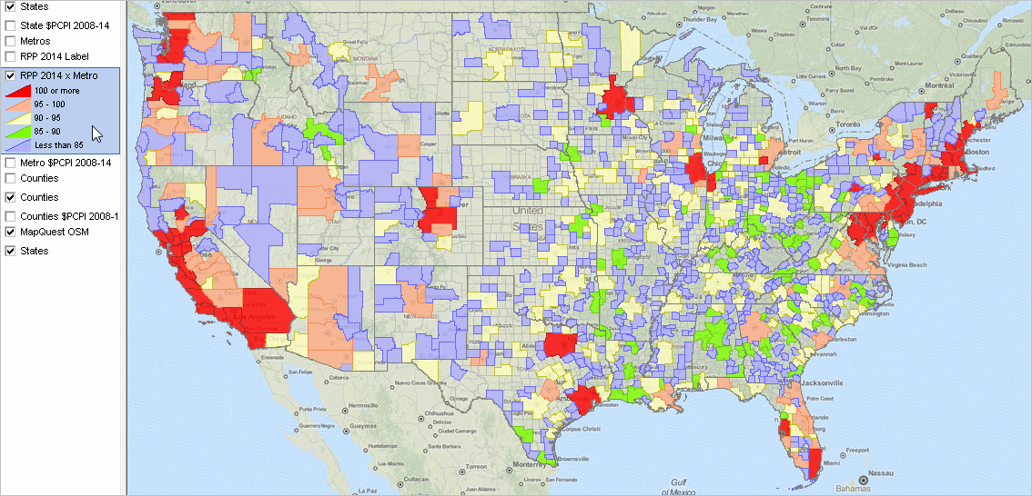 .. view developed using the CV XE GIS software. .. click map for larger view and details. Additional Views -- install GIS project (below) and create your own custom maps • Georgia & Region • Missouri & Region • Texas & Region Using the RPP; Current Estimates & Projections Illustrative examples: 1. Comparing real purchasing power: Houston, TX metro compared to Waco, TX metro. The the all items RPP for the Houston metro in 2014 was 100.3 while the all items RPP for the Waco, TX metro in 2014 was 91.5. (get from interactive table below). On average, prices are 0.3 percent higher and 8.5 percent lower than the U.S. average for the Houston metro and the Waco metro, respectively. The per capita personal income (PCPI) for the Houston metro in 2014 was $54,820 and the per capita personal income for the Waco metro was $35,340 (get from the table at http://proximityone.com/reis.htm). The RPP-adjusted PCPI values are $53,223 ($54,820/1.03) and $38,622 ($35,340/0.915), respectively. The gap between the purchasing power of the two metro PCPIs is reduced when adjusted by their respective RPPs. 2. Comparing real purchasing power: Washington, DC metro compared to Columbia, MO metro. • Washington, DC metro 2014 all items RPP: is 119.4 (table below); 2014 PCPI: $62,975 (from this table) • Columbia, MO metro 2014 all items RPP: 93.0 (table below); 2014 PCPI: $41,418 (from this table) • The RPP-adjusted PCPI values are $52,742 ($62,975/1.194) and $44,535 ($41,418/0.93), respectively. Current Estimates & Projections. ProximityOne uses the RPP data with other data to develop RPP current estimates (2016) and annual projections as a part of the Regional Demographic-Economic Modeling System (RDEMS). State & Metro Price Parities: 2008-2014 -- interactive table Use mouse-over on header column to view extended item/column name. Click ShowAll button between Find/Queries. See usage notes below table. Related ranking tables: http://proximityone.com/rankingtables.htm. Usage Notes Use mouse-over on header column to view extended item/column name. Click ShowAll button to reset table. Column Descriptions - Area name - St - GeoID -- state FIPS code or CBSA code - RPP Type - RPP Type Description - RPP 2008 - RPP 2009 - RPP 2010 - RPP 2011 - RPP 2012 - RPP 2013 - RPP 2014 - RPP Change 2013-14 - RPP Percent Change 2013-2014 - RPP Change 2010-2014 - RPP Percent Change 2010-2014 Analyzing RPP by Metro using GIS Resources (requires Windows computer with Internet connection) 1. Install the ProximityOne CV XE GIS ... run the CV XE GIS installer ... take all defaults during installation 2. Download the RPP GIS project fileset ... requires ProximityOne User Group ID (join now) ... unzip RPP Metro GIS project files to local folder c:\rpp 3. Open the c:\rpp\rpp_metro.gis project ... after completing the above steps, click File>Open>Dialog ... open the file named c:\rpp\rpp_metro.gis 4. Done. The start-up view is shown at top of this section. Regional Price Parities in 2014 In 2014, the District of Columbia's RPP (118.1) was higher than that of any state. The states with the highest RPPs were Hawaii (116.8), New York (115.7), New Jersey (114.5) and California (112.4). Mississippi (86.7), Arkansas (87.5), Alabama (87.8), South Dakota (88.0) and Kentucky (88.7) had the lowest RPPs among the states. States with high (low) RPPs typically have high (low) price levels for rents. States with RPPs closest to the national average price level were Vermont (101.2), Illinois (100.7), Florida (99.1), Oregon (99.0), and Rhode Island (98.7). In 2014, the metropolitan area with the highest RPP was Urban Honolulu, HI (123.5). Metropolitan areas with RPPs above 120.0 also included San Jose-Sunnyvale-Santa Clara, CA (122.9), New York-Newark-Jersey City, NY-NJ-PA (122.3), Santa Cruz-Watsonville, CA (121.8), San Francisco-Oakland-Hayward, CA (121.3) and Bridgeport-Stamford-Norwalk, CT (120.4). The metropolitan area with the lowest RPP was Beckley, WV (79.7), followed by Rome, GA (80.7), Danville, IL (81.1), Morristown, TN (81.9), and Jonesboro, AR (82.0). About Regional Price Parities and Implicit Regional Price Deflators Regional Price Parity estimates for states and metropolitan statistical areas have been developed for the period 2008-2014, annually by the Bureau of Economic Analysis (BEA). The estimates are updated/extended annually. The next update will be July 2017. Price indexes commonly measure price changes over time. The BEA Personal Consumption Expenditure (PCE) price index and the BLS Consumer Price Index (CPI) are two examples. Spatial price indexes measure price level differences across regions for one time period. An example of these type of indexes are purchasing power parities (PPPs), which measure differences in price levels across countries for a given period, and can be used to convert estimates of per capita GDP into comparable levels in a common currency. The regional price parities (RPPs) that BEA has developed compare regions within the United States, but without the need for currency conversion. An implicit regional price deflator (IRPD) can be derived by combining the RPPs and the U.S. PCE price index. Regional Price Parities. The RPPs are calculated using price quotes for a wide array of items from the CPI, which are aggregated into broader expenditure categories (such as food, transportation or education). Data on rents are obtained separately from the American Community Survey (>ACS). Expenditure weights for each category are constructed using CPI expenditure weights, the BEA PCEs, and ACS rents expenditures. The broader categories and the data on rents are combined with the expenditure weights using a multilateral aggregation method that expresses a region's price level relative to the U.S. For example, if the RPP for area A is 120 and for area B is 90, then on average, prices are 20 percent higher and 10 percent lower than the U.S. average for A and B, respectively. If the personal income for area A is $12,000 and for area B is $9,000, then RPP-adjusted incomes are $10,000 ($12,000/1.20) and $10,000 ($9,000/0.90), respectively. The purchasing power of the two incomes is equivalent when adjusted by their respective RPPs. Implicit Regional Price Deflator. The IRPD is a regional price index derived as the product of two terms: the regional price parity and the U.S. PCE price index. The implicit regional price deflator will equal current dollar personal income divided by real personal income in chained dollars. The growth rate or year-to-year change in the IRPDs is a measure of regional inflation. Support Using these Resources Learn more about demographic economic data and related analytical tools. Join us in a Data Analytics Lab session. There is no fee for these Web sessions. Each informal session is focused on a specific topic. The open structure also provides for Q&A and discussion of application issues of interest to participants. ProximityOne User Group Join the ProximityOne User Group to keep up-to-date with new developments relating to geographic-demographic-economic decision-making information resources. Receive updates and access to tools and resources available only to members. Use this form to join the User Group. Additional Information ProximityOne develops geographic-demographic-economic data and analytical tools and helps organizations knit together and use diverse data in a decision-making and analytical framework. We develop custom demographic/economic estimates and projections, develop geographic and geocoded address files, and assist with impact and geospatial analyses. Wide-ranging organizations use our software, data and methodologies to analyze their own data integrated with other data. Follow ProximityOne on Twitter at www.twitter.com/proximityone. Contact ProximityOne (888-364-7656) with questions about data covered in this section or to discuss custom estimates, projections or analyses for your areas of interest. |
|
|