
|
|
|
CV XE GIS GeoGateway -- develop custom GIS projects from scratch
Need a custom map of your market or study area? Online mapping services cannot show relevant political or statistical boundaries? Build your own custom map ... that can be a platform for much more than viewing maps and geography. The CV XE GIS GeoGateway feature is used to develop or extend the scope of a GIS project by adding new layers using files downloaded by this tool. See about file availability and access below in this section. This section illustrates how GeoGateway can be used. Create maps structured to meet your objectives. Access, download, organize the required shapefiles to meet your geospatial analysis needs. See more about using the GeoGateway feature in the CV XE GIS user guide. Illustrative Application Focused on the Austin, TX Area Use the steps described in detail below to create the following view and GIS project focused on Austin and Travis County, TX. Austin city shown with semi-transparent green fill pattern. Click graphic for larger view. Larger view shows mini profile for census tract at pointer. Expand browser window for best quality. 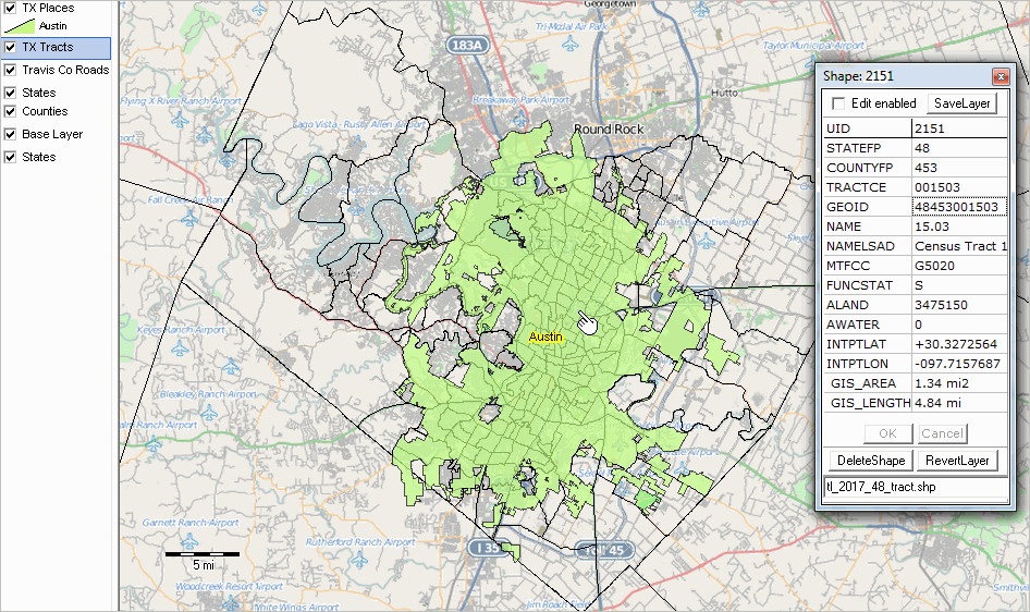 - view created with CV XE GIS using project developed with GeoGateway feature. Additional views: • Zoom-in to tract 48-453-150300; shows mini profile of selected road segment. Steps to Create Austin View/Project using GeoGateway Getting started: .. requires CV XE GIS software version dated 10/7/17 or more recent. .. Install update (requires userid) if a previous version exists. .. never installed? GeoGateway works with no fee User Group CV XE GIS version. join User Group ... check User Group and CV XE GIS checkbox. • Start CV XE GIS (use desktop icon) • No GIS project is required. .. Use File>Close to close current project (recommended for this tutorial). .. If no GIS project is open, CV XE GIS will create one. .. As new layers are added, the layer name is added to the top of the legend panel. View this video (11 min) to review steps summarized below. Summary of steps described below: 1. Start File>GeoGateway; a new form appears. 2. Add the Travis County, TX edges/roads shapefile/layer. 3. Add the Texas census tracts shapefile/layer. 4. Add the Texas places shapefile/layer. 5. Close GeoGateway form; perform mapping and analytical operations. 6. Make further layer modifications using the layer editor. 7. Optionally save the modified GIS project. Step-by-Step Details With CV XE GIS running, proceed as follows: - Select File>Close form the main menu bar (recommended, not required). 1. Start File>GeoGateway; a new form appears - shown in graphic at right.  2. Add the Travis County, TX edges/roads shapefile/layer.
In the "1. Select Geographic Scope" section, scroll down to TX 48453 Travis County.
- dblclick, name appears in "Selected Area". In the "2, Select Shapefile/GeoFile Type" section, dblclick EDGES line. Click Download button (in "File to Download" Section) - respond to prompts Following the "Done" message, in "Add Layer to Project" section ... - type "Travis Co Roads" (no double quotes) in the New Layer Caption edit box. - check the checkbox "Set GIS extent to Layer extent" - select "FULLNAME" (no double quotes) as Shape Label - type "ROADFLG='Y'" (no double quotes) into the Query edit box - click Add Layer to Project button 3. Add the Texas census tracts shapefile/layer.
In the "1. Select Geographic Scope" section, select Texas.
- dblclick, name appears in "Selected Area". In the "2, Select Shapefile/GeoFile Type" section, dblclick TRACT. Click Download button (in "File to Download" Section) - respond to prompts Following the "Done" message, in "Add Layer to Project" section ... - type "TX Tracts" (no double quotes) in the New Layer Caption edit box. - select null (no value) as "Shape Label" - click Add Layer to Project button 4. Add the Texas places shapefile/layer.
In the "2, Select Shapefile/GeoFile Type" section, dblclick PLACES.
Click Download button (in "File to Download" Section) - respond to prompts Following the "Done" message, in "Add Layer to Project" section ... - type "TX Places" (no double quotes) in the New Layer Caption edit box. - select null (no value) as "Shape Label" - type "GEOID='4805000'" (no double quotes) into the Query edit box - click Add Layer to Project button 5. Close GeoGateway form; perform mapping and analytical operations. 6. Make further layer modifications using the layer editor. 7. Optionally save the modified GIS project. Digital Map Database File Structure & Availability .. goto top The GeoGateway supports TIGER/Line file access and integration using TIGER vintages 2010, 2016, 2016S (smoothed) and 2017 shapefiles and related geographic files. Additional vintages are added as they become available. TIGER files may be accessed using the ProximityOne CV XE GIS GeoGateway feature. See these details about using the GeoGateway operations. The interactive shown below provides reference information about TIGER 2017 file availability that may be useful. The table contains a record/row for each type of available TIGER 2017 file. The files are organized into three types as shown in the left column: Boundary (polygon/area shapefile), Point-Line (point or line shapefile), File (dBase file). The type of geography is described in the Description column, Each of the file types is available for the U.S., State or state-county as shown in the rightmost three columns. The file availability columns shown the file name or file name template for the specific geographic availability level and type of file. For State availability, the code "st" is a placeholder for the state FIPS code. For State-County availability, the code "stcty" is a placeholder for the state FIPS code+county FIPS code. For example, Census Block shapefiles are available as state structured shapefiles (tl_2017_st_tabblock10.shp). For the state of Florida (FIPS code 12), the file name is tl_2017_12_tabblock10.shp. -- See usage notes below table. Usage Notes • Click column header to sort; click again to sort other direction. • Click ShowAll button to start a new query. • Use Select File Type to select/filter by type of file. - Click ShowAll button first. - Select File Type using dropdown. See related Interactive Tables Main Page About the Digital Map Database The Digital Map Database includes files created from the Census Bureau's TIGER (Topologically Integrated Geographic Encoding and Referencing) database of selected geographic and cartographic information. TIGER is used by the Census Bureau to support the mapping and related geographic activities required by the decennial and economic censuses and statistical survey programs. TIGER/Line shapefiles are available for public use and are typically used to provide the digital map base for GIS (Geographic Information System) and mapping applications. TIGER/Line files are digital, vector-based point, line and polygon shapefiles and related files. TIGER/Line shapefiles do not contain any demographic or other subject matter data though wide-ranging subject matter data can be knit-together with the shapefiles. TIGER/Line files are digital, vector-based point, line and polygon shapefiles and related files. TIGER/Line shapefiles do not contain any demographic or other subject matter data though wide-ranging subject matter data can be knit-together with the shapefiles. ProximityOne User Group Join the ProximityOne User Group to keep up-to-date with new developments relating to metros and component geography decision-making information resources. Receive updates and access to tools and resources available only to members. Use this form to join the User Group. Support Using these Resources Learn more about accessing and using demographic-economic data and related analytical tools. Join us in a Data Analytics Lab session. There is no fee for these one-hour Web sessions. Each informal session is focused on a specific topic. The open structure also provides for Q&A and discussion of application issues of interest to participants. Additional Information ProximityOne develops geodemographic-economic data and analytical tools and helps organizations knit together and use diverse data in a decision-making and analytical framework. We develop custom demographic/economic estimates and projections, develop geographic and geocoded address files, and assist with impact and geospatial analyses. Wide-ranging organizations use our tools (software, data, methodologies) to analyze their own data integrated with other data. Follow ProximityOne on Twitter at www.twitter.com/proximityone. Contact us (888-364-7656) with questions about data covered in this section or to discuss custom estimates, projections or analyses for your areas of interest. |
|
|
