
|
|
|
-- API-based data access & integration software -- part of the ProximityOne Explorer Studio March 2020 .. Exlorer360 is the ProximityOne premier software used to access, integrate, analyze and interpret demographic-economic data for wide-ranging types of geographic areas. Focused initially on using data from the American Community Survey (ACS2017 and ACS 2018), Explorer360 will be progressively expanded to include the ProximityOne Situation & Outlook database, Census 2010, Census 2020 and other data resources. This section provides an introduction to getting started with the ProximityOne Explorer360. Questions? Email Us. Start Using Explorer30 Now. Create demographic-economic profiles for any supported geographic area. See about steps 1-2-3 to create profiles for areas of interest. Topics in this Section .. go to top • Role & Scope .. Benefits & Features • How These Data Can Be Used • Installation .. Run Installer • User Interface and Operations Overview • Subject Matter Options • Geography Options • Terms of Use • Examples • Technical Reference • Tips & FAQ Role and Scope -- Benefits & Features Explorer360 operates on any Windows computer and uses API-based tools to access and analyze data in organized profiles and datasets. See these illustrative U.S. national scope profiles. Click a link to open a new web page. ACS 2018 1-year data: General Demographics .. Social Characteristics .. Economic Characteristics .. Housing Characteristics ACS 2018 5-year data: General Demographics .. Social Characteristics .. Economic Characteristics .. Housing Characteristics Create these four types of profiles for ACS 2017 or ACS 2018 using either 1-year estimates or 5-year estimates for more that 150,000 areas; see list below. Importance of These Data & How They Can be Used An important feature of the ACS data is that they are the only demographic-economic data that are annually updated, available as a standardized set of subject matter across all geography tabulated, and available for a wide range of geography from the national level to the sub-neighborhood level. These data fit the needs of businesses, government, academia, other organizations and individual stakeholders in application areas including knowledge development, research, program administration, planning, policy-making and evaluation. In a unique manner, these data help us better understand where we are know (e.g., economic prosperity, market penetration, demographic=economic balancing between/among areas, etc.), how things have changed and how they might change in the future. These data enable us to compare one geographic area to another or many others or a group of aggregated area attributes. A selection of topics included organized into four groups: General demographics - population by age, gender, race/origin Social characteristics ... - households and household composition - migration - language spoken at home - school enrollment & educational attainment - marital and fertility attributes - disability attributes - citizenship Economic characteristics - labor force composition - employment by occupation/industry - income by type - households by household/family income level - commuting - health insurance coverage - population & families in poverty Housing characteristics - housing units by occupancy - housing by units in structure - year structure built - mortgage status & attributes - units by tenure; owner/renter - housing unit value by interval - housing rent by interval To achieve the uses and benefits associated with these data requires software. Explorer360 is the software enabler. Installation .. go to top The Explorer360 is available members of the ProximityOne User Group at no fee. Install Explorer360 on a Windows computer using this link: • Explorer360 Installer • Your User Group ID and password are required. • See terms of use below in this section User Interface and Operations Overview .. go to top Partial view of user interface/start-up view: Click graphic for larer view. 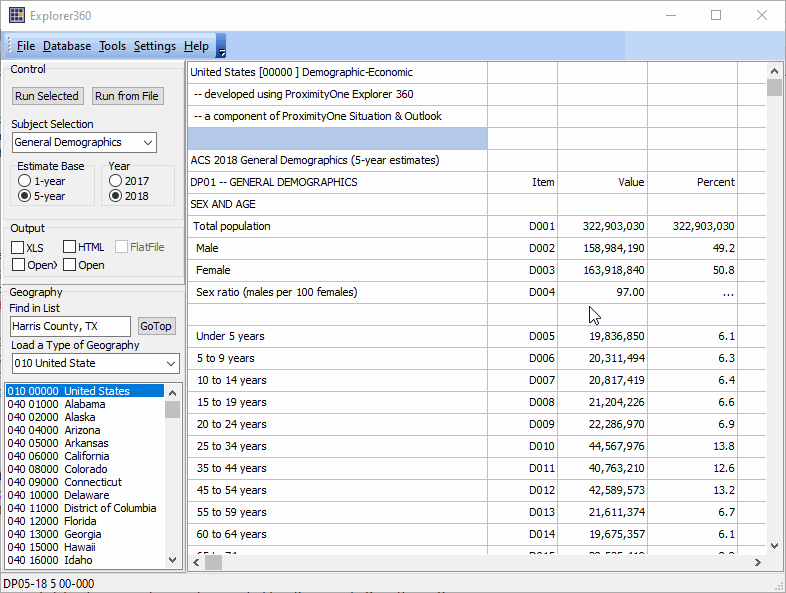 Organization: Main Menu Toolbar Grid Panel -- larger part of user interface - view/use the table/data generated here; perform selected operation Left Panel Group Sections - Control Panel - Subject matter selections; running the application. - Output Settings - Geography Selection and Operations See below for more information on use of these features. Subject Matter Options .. go to top Explorer360 progressively expands to include a wider range of statistical programs, time periods and subject matter. This version is focused on four ACS-based demographic-economic profiles: • General Demographics • Social Characteristics • Economic Characteristics • Housing Characteristics Geography Options .. go to top Explorer360 progressively expands to include a wider range of geography. This version is focused on geography reviewed below. Use the Geography dropdown to select a type of summary level. When the dropdown option is selected, the geography listbox repopulates with the requested summary level geographies. The U.S., state, county and metro are included with all selections. All summary levels 010 United States 040 State 050 County 140 Census Tract (73,056 areas) 160 City/Place (~29,000 areas) 300 Metro: MSA/MISA (~930 areas) 400 Urban Area (3,593 areas) 500 116th Congressional District 610 2018 Upper State Legislative District 620 2018 Upper State Legislative District 860 ZIP Code Area (33120 areas) 950 School District Technical Reference .. go to top Structure & Use of User Interface Toolbar at top with menu items Grid Panel -- largest part of user interface displays data generated in Level 2 a flat file is optionally displayed here with spreadsheet operations Left Panel Groups Control Output Geography
Find in List
Statusbar at bottomLoad Type of Geography Geography Listbox Output File Names When the Output XLS or HTM are checked, files are written to the c:\explorer360\1 folder. The Houston ISD, TX HTM file is generated as "acs1859704823640d.htm" (no quotes). The file name is constructed as parts: acs-18-5-970-4823640-d.htm (dashes not included in file name), where: acs is the main statistical program descriptor 18 is the program year 5 is the estimates period; 1 for 1-year, 5 for 5-year 970 is the summary level 4823640 is the national scope unique geocode d is the type of profile; d indicates general demographics htm or xls are the type of extension. Terms of Use .. go to top The Explorer360 level 1 is available for use by members of the ProximityOne User Group. There is no warranty of any type associated with any aspect of the use of Explorer360 or its output. The user is solely responsible for any use made of Explorer 360. Explorer360 may not be redistributed. Using Explorer360; Example 1 .. go to top Create the U.S. 4 demographic profiles using the ACS 2018 1-year estimates ... With Explorer360 running, verify the Geography listbox shows the United States as selected (highlighted blue): Check the HTML and Open checkboxes. 1 Click Run Selected button .. generating the General Demographic profile (the Subject Selection default). the grid populates, generates and displays the HTML profile 2 Select Social Characteristics and click Run Selected button. the grid populates, generates and displays the HTML profile 3 Select Economic Characteristics and click Run Selected button. the grid populates, generates and displays the HTML profile 4 Select Social Characteristics and click Run Selected button. the grid populates, generates and displays the HTML profile Example 2 -- Creating Profiles for a School District .. go to top Create the 4 demographic profiles using the ACS 2018 5-year estimates for the Houston ISD, TX school district ... With Explorer360 running, check the HTML and Open checkboxes (options). School District geography is required; use the Load Type of Geography dropdown and select School District. The Geography listbox reloads. Scroll to the desired school district or use the Find in List feature to locate the name. In this case, key in "Houston I" (no quotes). This illustrates that only a partial unique search key is needed. dbl-click the Find in List edit box and the Houston ISD, TX is located in the Geography listbox. dbl-click the Houston ISD, TX item in the geography listbox. 1 the General Demographic profile displays in the grid. 2 Select Social Characteristics and dbl-click the Houston ISD, TX item; profile displays. 3 Select Economic Characteristics and dbl-click the Houston ISD, TX item; profile displays. 4 Select Social Characteristics and dbl-click the Houston ISD, TX item; profile displays. Note that any the profile can be generated for any area by dbl-clicking that item in the Geography listbox. Tips & Frequently Asked Questions .. go to top How do I create a profile for a city? See example below. br> How to Access a ZIP Code Profile? Relating ZIP Codes to Census Tracts Steps to create an ACS 2018 5-year HTML/Web Economic Profile for ZIP Code 85258 (Scottsdale, AZ). With Explorer360 running with default settings: • Use Select Type of Geography & select ZIP Code Area. • When Geography Listbox repopulates, use Find in List to locate 85258. • Select Economic Characteristics from Select Subject Matter in Control Panel. • Dbl-click 85258 in Geography Listbox. • The 2018 ACS 5-year median household income is $84,334. What is the median family income? How to Access a Census Tract Profile? Relating ZIP Codes to Census Tracts Steps to create an ACS 2018 5-year HTML/Web Economic Profile for Census Tract 04013216813 (Scottsdale, AZ). With Explorer360 running with default settings: • Use Select Type of Geography & select Census Tract. • When Geography Listbox repopulates, use Find in List to locate 04013216813. • Select Economic Characteristics from Select Subject Matter in Control Panel. • Dbl-click 04013216813 in Geography Listbox. • The 2018 ACS 5-year median household income is $107,437. What is the median family income? How to Access a City Profile? Aout City/Place Geography & Characteristics Steps to create an ACS 2018 5-year HTML/Web Economic Profile for Scottsdale, AZ. With Explorer360 running with default settings: • Use Select Type of Geography & select 160 Cities/Places. • When Geography Listbox repopulates, use Find in List to locate Scottsdale, AZ. • Select Economic Characteristics from Select Subject Matter in Control Panel. • Dbl-click 160 Scottsdale, AZ in Geography Listbox. • The 2018 ACS 5-year median household income is $107,437. What is the median family income? Additional Information ProximityOne develops geodemographic-economic data and analytical tools enabling stakeholders to knit together and use diverse data in a decision-making and analytical framework. We develop custom demographic/economic estimates and projections, develop geographic and geocoded address files, and assist with impact and geospatial analyses. Wide-ranging organizations use our tools (software, data, methodologies) to analyze their own data integrated with other data. Follow ProximityOne on Twitter at www.twitter.com/proximityone. Contact us (888-364-7656) with questions about data covered in this section or to discuss custom estimates, projections or analyses for your areas of interest. |
|
|