
|
|
|
-- 2020-2022 annual population & components of change -- expanding insights through data analytics December 2022 .. after a historically low rate of change between 2020 and 2021, the U.S. resident population increased by 0.4%, or 1,256,003, to 333,287,557 in 2022. These data are based on Census Bureau post-Census 2020 estimates released in December 2022. Net international migration, the number of people moving in and out of the country, added 1,010,923 people between 2021 and 2022. It was the primary driver of growth. Net international migration represents 168.8% growth over 2021 totals of 376,029 -- an indication that migration patterns are returning to pre-pandemic levels. Positive natural change (births minus deaths) increased the population by 245,080. These data are integrated into updated ProximityOne 2060 projections. This section provides data and tools to access and use the latest population estimates and components of change. Use the interactive table below to view, rank, compare the estimates and components of change. Use the VDA Web GIS to view patterns and geospatially anlayze these data in context of other geography and subject matter. How State Population is Changing, 2020-2022 The following graphic shows patterns of population percent change by state from 7/1/21 to 7/1/22. The color patterns/intervals are shown in the inset legend. In the larger view (click graphic), states are labeled with 7/1/21-7/1/22 percent change. Click graphic for larger view. Expand browser to full window for best quality view. 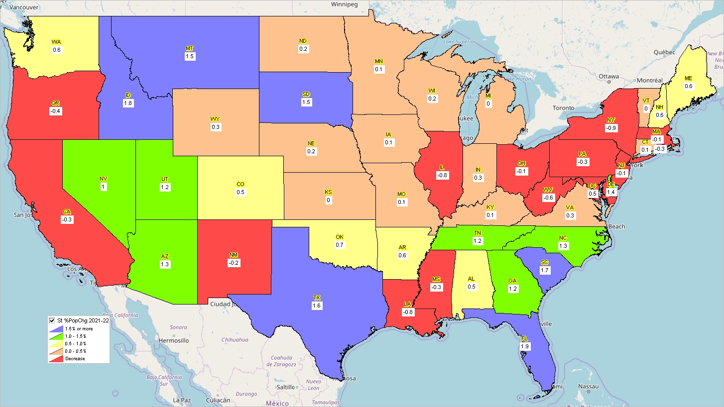 .. view developed using the CV XE GIS software. .. view using the VDA Web GIS .. nothing to install; requires only a browser; device independent; use any browser. .. click map for larger view and details. Interactive Table.. goto top Use the table below , for example, to see that between 7/1/2021 and 7/1/2022, the U.S. growth was 1,256,003 or 0.4%. Use the table to compare how states of interest rank and are changing. U.S. & State Population & Components of Change: 2020-2022 .. interactive table .. goto top Use mouse-over on header column to view extended item/column name. Click ShowAll button between queries. See usage notes below table. Related ranking tables: interactive tables. Usage Notes Use mouse-over on header column to view extended item/column name. Click ShowAll button to reset table. Column Descriptions .. goto top
- Area Name
- Geographic summary level - Census Region code - Census Division code - State FIPS code - 4/1/2020 resident total population estimates base - 7/1/2020 resident total population estimate - 7/1/2021 resident total population estimate - 7/1/2022 resident total population estimate - 7/1/2022-7/1/2021 resident total population change - 7/1/2022-7/1/2021 resident total population percent change - Change in resident total population 4/1/2020 to 7/1/2020 - Change in resident total population 7/1/2020 to 7/1/2021 - Change in resident total population 7/1/2021 to 7/1/2022 - Births in period 4/1/2020 to 6/30/2020 - Births in period 7/1/2020 to 6/30/2021 - Births in period 7/1/2021 to 6/30/2022 - Deaths in period 4/1/2020 to 6/30/2020 - Deaths in period 7/1/2020 to 6/30/2021 - Deaths in period 7/1/2021 to 6/30/2022 - Natural change in period 4/1/2020 to 6/30/2020 - Natural change in period 7/1/2020 to 6/30/2021 - Natural change in period 7/1/2021 to 6/30/2022 - Net international migration in period 4/1/2020 to 6/30/2020 - Net international migration in period 7/1/2020 to 6/30/2021 - Net international migration in period 4/1/2021 to 6/30/2022 - Net domestic migration in period 4/1/2020 to 6/30/2020 - Net domestic migration in period 7/1/2020 to 6/30/2021 - Net domestic migration in period 7/1/2021 to 6/30/2022 - Net migration in period 4/1/2020 to 6/30/2020 - Net migration in period 7/1/2020 to 6/30/2021 - Net migration in period 7/1/2021 to 6/30/2022 Population Components of Change go to top The population in period t (P[t]) for an area is defined using the identity: P[t]:=P[t-1]+B[t]-D[t]+IM[t]+DM[t], where: - P[t] -- resident population as of 7/1/t - P[t-1] -- resident population as of 7/1/t - B[t] -- births during the period 6/30/t-1 to 7/1/t - D[t] -- deaths during the period 6/30/t-1 to 7/1/t - IM[t] -- international migration during the period 6/30/t-1 to 7/1/t - DM[t] -- domestic during the period 6/30/t-1 to 7/1/t B, D, IM and DM are the components of change. REGION codes 1 = Northeast 2 = Midwest 3 = South 4 = West DIVISION codes 1 = New England 2 = Middle Atlantic 3 = East North Central 4 = West North Central 5 = South Atlantic 6 = East South Central 7 = West South Central 8 = Mountain 9 = Pacific Support Using these Resources .. goto top Learn more about demographic economic data and related analytical tools. Join us in a Data Analytics Lab session. There is no fee for these Web sessions. Each informal session is focused on a specific topic. The open structure also provides for Q&A and discussion of application issues of interest to participants. ProximityOne User Group Join the ProximityOne User Group to keep up-to-date with new developments relating to geographic-demographic-economic decision-making information resources. Receive updates and access to tools and resources available only to members. Use this form to join the User Group. Additional Information ProximityOne develops geographic-demographic-economic data and analytical tools and helps organizations knit together and use diverse data in a decision-making and analytical framework. We develop custom demographic/economic estimates and projections, develop geographic and geocoded address files, and assist with impact and geospatial analyses. Wide-ranging organizations use our software, data and methodologies to analyze their own data integrated with other data. Follow ProximityOne on Twitter at www.twitter.com/proximityone. Contact ProximityOne (888-364-7656) with questions about data covered in this section or to discuss custom estimates, projections or analyses for your areas of interest. |
|
|