
|
|
|
State Population & Components of Change: 2010-2016
December 2016 .. examining how state demographics are changing 2010-2016 ... using the new 2016 population and components of changes estimates. The U.S. population changed from 308,758,105 (2010) to 323,127,513 (2016), a change of 14,369,408 (4.7%). Only three states lost population. See the growth rates for DC and the remaining states in this table. Highest growth rates were in D.C., North Dakota, Texas, Utah and Colorado. December 2017 update ... this section has been updated. -- see http://proximityone.com/states2017.htm This section provides access to tools to view and analyze annual population estimates, 2010 to 2016, rankings and components of change for the U.S., regions and states. Use the interactive table below in this section to view, rank, compare these data. Use the GIS tools and ready-to use project described below in this section to create maps for states and regions of interest. Create thematic maps for any of the fields/measures shown in the interactive table. Change color patterns and labels. Integrate your own data. See more about these data Patterns of Population Change, 2010-2016, by State The following graphic shows the percent population change by state with labels showing the rank among all states based on the percent change in population, 2010-16. 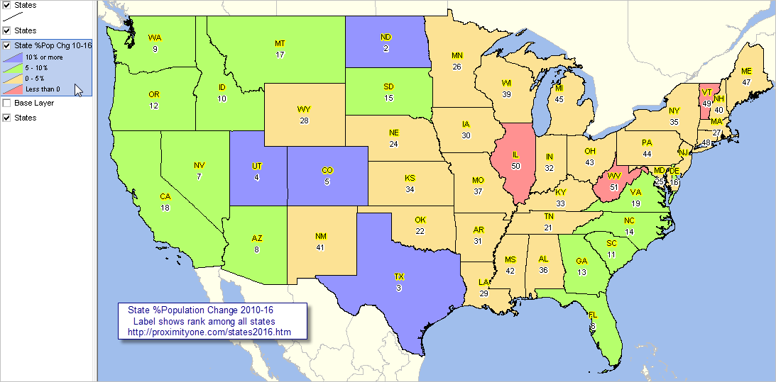 View created with CVGIS and related GIS project. Click graphic for larger view. Using new 2016 U.S. by state demographic and income data .. and trend analysis .. this section focuses on tools and data resources that you can use to examine selected U.S. by state 2015 demographic-economic characteristics. Aside from using predictive models, data on U.S. by state conditions, enabling trend analysis, cannot be developed until December of the corresponding year. ProximityOne integrates these and related other data into the Situation & Outlook database and information system. These data are part of the historical used in our models to develop projections and perform predictive analyses -- a constantly changing process. State Population & Components of Change: 2010-2016 Click ShowAll button between Find/Queries. See usage notes below table. Use mouseover on column header to view column description. See related demographic-economic interactive tables. Usage Notes The start-up view shows total population by year as columns. Data for U.S., regions and states are shown as rows. • Click ShowAll button between Find/Queries. • Click column header cell to sort; click again to sort in other direction. • Use mouseover on column header to view column description. • Click "Change/Rank Cols" button to view only the population change 2010-2016 and ranking columns. .. rank values in table show rank among all states. • Click "Comp Chg Cols" button to view only the population components of change columns. • Click "All Cols" button to view all columns. • Copy a row to clipboard then paste in worksheet for further analysis. .. check the checkbox in a row, right-click row (in blue area), select copy, paste into worksheet or text file. Reference to "Change 2010base-2016" refers to change from the 4/1/10 base value to the 7/1/16 estimate. See about Census Regions (state groups) geography. Columns/Items - Area Name - Population Census 2010 4/1/10 - Population Census 2010 Base 4/1/10b - Population 7/1/10 - Population 7/1/11 - Population 7/1/12 - Population 7/1/13 - Population 7/1/14 - Population 7/1/15 - Population 7/1/16 - Population Change 2010base-2016 - %Population Change 2010base-2016 - Population Change Rank among states 2010base-2016 - %Population Change Rank among states 2010base-2016 - Population Change 2010base-2016 - Natural Increase 2010base-2016 - Births 2010base-2016 - Deaths 2010base-2016 - Migration 2010base-2016 - Migration, International 2010base-2016 - Migration, Domestic 2010base-2016 U.S. by State 2016 Population GIS Project/Datasets 1. Install the ProximityOne CVGIS ... omit this step if CVGIS software already installed. ... run the CVGIS installer ... take all defaults during installation 2. Download the States Population 2016 GIS project fileset ... requires ProximityOne User Group ID (join now) ... unzip States Population 2016 GIS project files to local folder c:\statetrends 3. Open the c:\statetrends\stpop_2010_2016.zip project ... after completing the above steps, click File>Open>Dialog ... open the file named c:\statetrends\stpop_2010_2016.gis 4. Done. The start-up view is similar to the graphic shown at the top of this section. Annual State Total Population Estimates Developing data to examine population change may seem simple, but it is not. The Census Bureau, developer of the official population estimates/counts, operates a continuing annual program to prepare the latest population estimates. A cycle, of sorts, starts in December of the current estimate years -- national level 2016 total population estimates (data for July 1, 2016) are released in December 2016 (corresponding 2017 data will be released in December 2017). National level total population estimates are accompanied by 2016 components of change estimates (births, deaths and migration). More detailed, model-based, state and county estimates are developed in a progression of steps during January through June of the next year/2017. Here we look only at the estimates released in December 2016. ProximityOne User Group Join the ProximityOne User Group to keep up-to-date with new developments relating to metros and component geography decision-making information resources. Receive updates and access to tools and resources available only to members. Use this form to join the User Group. Support Using these Resources Learn more about accessing and using demographic-economic data and related analytical tools. Join us in a Data Analytics Lab session. There is no fee for these one-hour Web sessions. Each informal session is focused on a specific topic. The open structure also provides for Q&A and discussion of application issues of interest to participants. Additional Information ProximityOne develops geodemographic-economic data and analytical tools and helps organizations knit together and use diverse data in a decision-making and analytical framework. We develop custom demographic/economic estimates and projections, develop geographic and geocoded address files, and assist with impact and geospatial analyses. Wide-ranging organizations use our tools (software, data, methodologies) to analyze their own data integrated with other data. Follow ProximityOne on Twitter at www.twitter.com/proximityone. Contact us (888-364-7656) with questions about data covered in this section or to discuss custom estimates, projections or analyses for your areas of interest. |
|
|