
|
|
|
-- analyzing patterns & trends: ACS 2012-2017 February 2019. The U.S. civilian employed population increased from 142.9 million in 2012 to 155.1 million in 2017, an increase of 12.1 million (8.5%) based on the American Community Survey (ACS) 1-year estimates. The table presented below shows how the employed population were distributed by occupation in 2012, 2017 and the 5-year change. Patterns of Percent Employed in Health Occupations by Census Tract The following graphic shows patterns of the employed population in health occupations as a percent of total civilian employed population ages 16 and over in the Minneapolis-St. Paul metro. This view uses the occupational category MBSA40 Healthcare practitioners and technical listed in scroll section below. Tracts with blue or green pattern exceed the national average as shown in table below. Click graphic for larger view, more detail (shows schools layer) and legend color/data intervals. This map illustrates the geographic level of detail available using census tract demographics and the relative ease to gain insights using geospatial data analytics tools. View graphic below showing tract with the largest employment in the "Healthcare practitioners and technical" occupational group among all tracts.  - View developed using CV XE GIS and related GIS project. Drill-down to Census Tract Level Examining patterns of employment by occupation, for the same scope of subject matter, at the sub-county level can provide more insights. What is the size of the employment for a selected occupation in a neighborhood or market/service area of interest? How has the size of an occupational group by census tract changed over the past five years? How do these patterns rank/compare by tract in a particular state, metro or county? Data on employment by occupational category from the Federal statistical system on a U.S. national scale for counties, cities and census tracts are only available from the American Community Survey (ACS). This section is focused on tools, resources and methods that you can use to access, integrate and analyze employment by occupation for the U.S. by census tract. Use the interactive table in this section to view, query, rank, compare census tract occupational characteristics, patterns and trends. Data in this section are based on the American Community Survey (ACS) 2017 5-year estimates. Related sections with census tract interactive tables: - General Demographics .. Social .. Economic .. Housing Current Estimates & Projections ACS tract/small area estimates lag by four years or more between the current year and reference year. ACS does not produce current year annual estimates but estimates based on a 5-year period. The 2017 ACS estimates are centric to 2015. Use the ProximityOne annual tract estimates and projections 2010 through 2023 for current year (e.g., characteristics as of 2018) estimates and anticipated change 5 years ahead. Using the Interactive Table Use the interactive ranking table below to view, query, rank, compare employment by occupation by census tract. The scroll box shown below lists each of the occupational groups available for each tract via the interactive table. The item name at the left of the occupational category is used as the short name for the subject matter item in the column header in the table. The table contains one row/record for each census tract in the U.S. Columns show ACS 2012 and 2017 employment by occupation. Occupational Group Items
TotPop Total population
TotEmp Total Civilian employed population 16 years and over MBSA00 Management, business, science, and arts MBSA10 Management, business, and financial MBSA11 Management MNSA12 Business and financial operations MBSA20 Computer, engineering, and science MBSA21 Computer and mathematical MBSA22 Architecture and engineering MBSA23 Life, physical, and social science MBSA30 Education, legal, community service, arts, and media MBSA31 Community and social service MBSA32 Legal MBSA34 Education, training, and library MBSA35 Arts, design, entertainment, sports, and media MBSA40 Healthcare practitioners and technical MBSA41 Health diagnosing and treating practitioners and other technical MBSA42 Health technologists and technicians SVC00 Service SVC10 Healthcare support SVC20 Protective service SVC21 Fire fighting and prevention, and other protective service workers including supervisors SVC22 Law enforcement workers including supervisors SVC30 Food preparation and serving related SVC40 Building and grounds cleaning and maintenance SVC50 Personal care and service SOF00 Sales and office SOF10 Sales and related SOF20 Office and administrative support NRC00 Natural resources, construction, and maintenance NRC10 Farming, fishing, and forestry NRC20 Construction and extraction NRC30 Installation, maintenance, and repair PTM00 Production, transportation, and material moving PTM10 Transportation PTM20 Material moving Employment Occupation by Census Tract; ACS 2012-2017 Interactive Table Click ShowAll button between queries. Click column header to sort; click again to sort other direction. See usage notes below table. Data based on ACS 2012 & 2017 5 year estimates. See related interactive tables Usage Notes • Tract code column: Census 2010 census tract code (2017 vintage) structured as 11 characters: - ss (state postal code) + ccc (county FIPS code) + tttttt (Census 2010 census tract code). - all 11 characters required to uniquely identify a tract code. • Use Select Tract button to select one tract: - enter 11-character State+County FIPS code in edit box at right of Tract button. - click ShowAll button. - click Select Tract button to view/analyze selected tract. • Use StCty button to select/filter for all tracts in a county: - enter 5-character State+County FIPS code in edit box at right of StCty button. - click ShowAll button. - click StCty button to view/analyze tracts in this county. • Use CBSA button to select/filter for all tracts in a CBSA/metro: - get 5-character CBSA code from scroll section at right above table. - enter CBSA 5-character code in edit box at right of CBSA button. - click ShowAll button. - click CBSA button to view/analyze tracts in this CBSA. • Click ShowAll button between specific queries. Use address look-up tool to determine census tract, city/place and other geocode/area name/demographics based on address. U.S. Employment by Occupation; 2012, 2017 & Change .. goto top
Tract 48-039-660602 Brazoria County, TX .. goto top The following graphic shows location of the tract (at pointer) with the largest ACS 2017 employment in the "Healthcare practitioners and technical" (MBSA40) occupational group among all tracts. 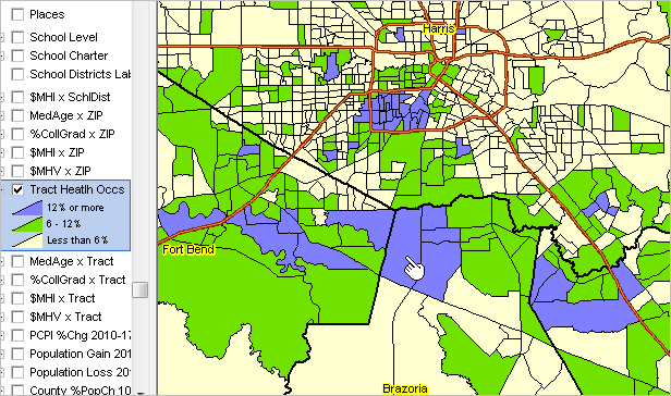 - View developed using CV XE GIS and related GIS project. San Antonio/Bexar County, TX Area .. goto top The following graphic shows patterns of ACS 2017 employment in the "Healthcare practitioners and technical" (MBSA40) occupational group for tracts in the San Antonio/Bexar County, TX area. 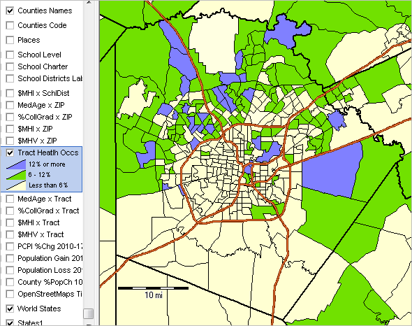 - View developed using CV XE GIS and related GIS project. Importance of Census Tracts for Data Analytics .. goto top Census tracts are important for many reasons. • Covering the U.S. wall-to-wall, census tracts are the preferred "small area" geography for superior data analytics. • The Census Bureau now produces annual tract demographic-economic data from the American Community Survey; .. there is an evolving time-series at the tract level creating new analytical opportunities. • Originally developed to equivalence neighborhoods, many still do. • Defined by the Census Bureau in collaboration with local groups, .. tracts typically reflect boundaries meaningful for local area analysis. • Defined generally for use with each new decennial census, most tract boundaries are stable .. and non-changing for ten years and many much longer. • Designed to average 4,000 population, .. there are more than twice as many census tracts (73,056) than ZIP code areas (33,129). • Tract boundaries are well-defined; unlike ZIP code areas which are subject to multi-sourced geographic definitions. • Many data developers (e.g., epidemiologists) use census tract geography to tabulate their own small area data .. enabling more effective use of those data with Census Bureau census tract data. • A statistical geographic area (in contrast to politically defined areas), .. census tracts are coterminous with counties; .. data at the census tract level can be aggregated to the county level. • Small area estimates for tracts are typically more reliable than for block groups. .. census tracts are comprised on one or more coterminous block groups. .. on average, a census tract is comprised of three block groups. • Census tracts are used by many Federal, state and local governments for compliance and program management. The ACS provides "richer" demographic-economic characteristics for national scope census tracts. While Census 2010 provides data similar to those items in the General Demographics section, only ACS sourced data provide details on topics such as income and poverty, labor force and employment, housing value and costs, educational participation and attainment, language spoken at home, among many related items. The approximate 600 items accessible via the tract dataset are supplemented by a wide range of additional subject matter. ACS census tract data are updated annually in December of each year. Find Geocodes Based on Address .. go top Summary of steps to use the "Find tract code based on address..." tool located in the upper right of this page. • Enter an address in the three line form (no ZIP code). • Click Find button and the census tract and related geocodes are returned. • Copy the last 11 digits of the returned GEOID to clipboard (e.g., 06085508101). • Paste that value in the edit box to the right of the "Select Area" button below the interactive table. • Replace the first two characters (e.g., 06) with the uppercase USPS state abbreviation (e.g. CA). • Click the Select Area button; the table refreshes with the selected tract. .. optionally right click the row and copy tract attributes to clipboard. .. paste in application such as spreadsheet program. .. join us in a Data Analytics Lab session to review use of operations. • Table empty? Click the ShowAll button then click Select Area button again. Use the Location-Based Demographics tool to view a demographic profile for an address. ProximityOne User Group .. goto top Join the ProximityOne User Group to keep up-to-date with new developments relating to metros and component geography decision-making information resources. Receive updates and access to tools and resources available only to members. Use this form to join the User Group. Support Using these Resources Learn more about accessing and using demographic-economic data and related analytical tools. Join us in a Data Analytics Lab session. There is no fee for these one-hour Web sessions. Each informal session is focused on a specific topic. The open structure also provides for Q&A and discussion of application issues of interest to participants. Additional Information ProximityOne develops geodemographic-economic data and analytical tools and helps organizations knit together and use diverse data in a decision-making and analytical framework. We develop custom demographic/economic estimates and projections, develop geographic and geocoded address files, and assist with impact and geospatial analyses. Wide-ranging organizations use our tools (software, data, methodologies) to analyze their own data integrated with other data. Follow ProximityOne on Twitter at www.twitter.com/proximityone. Contact us (888-364-7656) with questions about data covered in this section or to discuss custom estimates, projections or analyses for your areas of interest. |
|
|
