
|
|
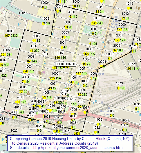
-- Address Counts by Census 2010 Block March 2020. The Census Bureau has released preliminary Census 2020 residential address counts by Census 2010 census block. These data, count of residential addresses and group quarters addresses, reflect updates as of October 2019 and do not represent final Census 2020 counts. The data will continue to be updated to support Census 2020. Importance and Use These data are of immediate value in determining and analyzing how the number of housing units have changed, 2010 to 2019. Since the data are at the census block level, they may be aggregated to any other Census-defined summary level/type of geographic area such as block group, tract, ZIP code, city, county, school district, etc. These data are also important as they give us a "year in advance look" at how small area demographics are changing since 2010. Before this, the most recent census block data were from Census 2010. A lot has happened in many areas. These data provide insights into that change. The Census 2020 block level data will be released in early 2021 for Census 2020 census block geography. So, another important feature of these data is that they are summarized for Census 2010 census block boundaries. Census 2010 and 2020 block boundaries may differ, particularly in areas experiencing larger demographic growth/change. An important limitation is that they are counts, subject to change as the Census data are collected/tabulated. Comparing Census 2010 Housing Units with Census 2020 Residential Address Counts ... goto top The following graphic shows patterns of Census 2010 housing counts with the Census 2020 (late 2019 vintage) residential address counts by census block. This view is focused on census tract 3608100700 (tract 000700) in Queens County, NY (code shown near center of graphic). Individual blocks are labeled with block code (4 digits) with the Census 2010 housing units (yellow label) and Census 2020 residential address count (green label) shown below the block code. As an example, the block located at the pointer has block code 3006 (or full national scope unique block code 36-081-00700-3006) with a Census 2010 count 44 housing units and a Census 2020 (late 2019 count) of 232 residential addresses. Click graphic for larger view. Expand browser window to full screen for best quality view.  .. view created with ProximityOne CV XE GIS software and related GIS project. See more detail on New York City region geodemographics. ProximityOne User Group Join the ProximityOne User Group to keep up-to-date with new developments relating to metros and component geography decision-making information resources. Receive updates and access to tools and resources available only to members. Use this form to join the User Group. Support Using these Resources Learn more about accessing and using demographic-economic data and related analytical tools. Join us in a Data Analytics Lab session. There is no fee for these one-hour Web sessions. Each informal session is focused on a specific topic. The open structure also provides for Q&A and discussion of application issues of interest to participants. Additional Information ProximityOne develops geodemographic-economic data and analytical tools and helps organizations knit together and use diverse data in a decision-making and analytical framework. We develop custom demographic/economic estimates and projections, develop geographic and geocoded address files, and assist with impact and geospatial analyses. Wide-ranging organizations use our tools (software, data, methodologies) to analyze their own data integrated with other data. Follow ProximityOne on Twitter at www.twitter.com/proximityone. Contact us (888-364-7656) with questions about data covered in this section or to discuss custom estimates, projections or analyses for your areas of interest. |
|
|