|
|
Decision-Making Information

|
ProximityOne
information resources & solutions
(888) DMI-SOLN
(888) 364-7656
What you will be able to do ..
your geography & subject matter
California 710,145 census blocks
mapped by census block polygon
Display time: 6 seconds
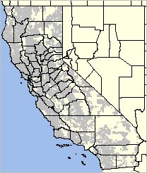
California 710,145 census blocks
where population greater than zero
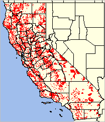
Zoom to Orange County, CA area
Thematic pattern view
Census Blocks by Primary Race
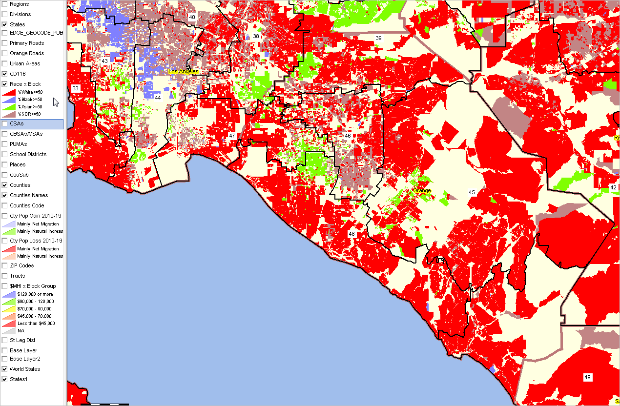
click for larger view
Data Analytics Blog
Power of Combining Maps with Data
Support & Technical Assistance
help using these resources
|
Using GIS Tools & GeoDemographics
.. self-paced, online course
.. by Warren Glimpse, founder of ProximityOne
- developer of GBF/DIME & prototype for Census Bureau digital map database
This section provides an overview of the ProximityOne "Using GIS Tools & GeoDemographics" course.
It serves as a home page for those registered for the course.
Registrants may click Section links to proceed with a particular section
(userid and password required). More detail is provided in each section.
The sections are designed to be taken in order. Each section includes assignments. All assignments must be completed to receive the
Certificate in GIS.
This program uses the
Visual Data Analytics GIS suite of tools and
Windows-based CV XE GIS software.
Using the GIS software enables a real world and full experience using
geographic, business, demographic and economic data and developing insights.
However, most topics covered in this program are relevant to any software that can use shapefiles.
See the Registration page for overview and to register.
The four mudules described below are presented in sequence in the four weekly
Thursday Web sessions each month.
They are repeated each month with updates as applicable. These sessions are designed for participants with no previous GIS experience
as well as experienced GIS users.
Contents
These links are for registrants and require a userid. The scope of each section is further described below.
• Section 1 -- About GIS; GIS Tools and Data Setup/Installation
• Section 2 -- Geography, Geometry & Shapefiles
• Section 3 -- Subject Matter: Statistical/Administrative Data
• Section 4 -- Integrating Subject Matter with Shapefiles
Interpreting & Presenting Data
Section 1 -- About GIS & GIS Tools and Data Setup/Installation
Learning Objectives
• Ability to start, operate and understand GIS tools/software with GIS project
• Ability to modify and save GIS Project
• Ability to create reference and thematic pattern maps
Topics
| Use | Use of these Course Materials |
| 1.1. | Introduction to Geographic Information Systems |
| 1.1.1. | Concepts, Terms |
| 1.1.1.1. | About GIS |
| 1.1.1.2. | CV XE GIS User Guide |
| 1.2. | An Application: How & Why County Demographics are Changing |
| 1.3. | Setting GIS Application Objectives: Mapping & GeoSpatial Analysis |
| 1.4. | Installing CV XE GIS & Overview |
| 1.4.1. | Run the CV XE GIS Installer |
| 1.4.2. | Navigating the CV XE GIS Software |
| 1.4.2.1. | Opening & Closing a GIS Project |
| .. | ... more .. details in course material |
| 1.5. | Reviewing the Start-Up GIS Project |
| 1.5.1. | GIS Project Structure |
| 1.5.1.1. | Saving and Naming GIS Projects |
| 1.5.1.2. | Using the Layer Editor |
| 1.5.2. | Shapefiles: Point, Line, Area; Structure |
| 1.5.3. | Data Files (other than shapefiles): Structure and Content |
| 1.5.3.1. | Excel, dBase, delimited, other |
| 1.6. | Making a Custom Map |
Section 2 -- Geography, Geometry & Shapefiles .. goto top
Learning Objectives
• Understand geographic summary levels, geocodes
• Understand shapefile structure and use
• Ability to access and use pre-existing shapefiles
• Ability to address code address data and create related shapefile
Topics
| 2.1. | Geography, Geometry & Shapefiles |
| 2.1.1. | Digital Map Database; Role of Shapefiles |
| 2.2. | Geographic Summary Levels |
| 2.2.1. | About Census Bureau Summary Levels; Role & Use |
| 2.2.1.1. | 100 Census Blocks |
| 2.2.1.2 | 150 Block Groups |
| 2.2.1.3 | 140 Census Tracts |
| 2.2.1.4. | 300 CBSAs/Metros |
| .. | .. more |
| 2.2.2. | Small Geography/Data: Blocks, Block Groups; Tracts vs ZIP Codes |
| 2.3. | Shapefile Vintages |
| 2.4. | Geocodes |
| 2.4.1. | State-County |
| .. | .. more |
| 2.5. | Geographic Equivalence Files |
| 2.5.1. | Block Group to ZIP Code |
| 2.5.2. | ZIP Code to County/Metro |
| .. | .. more |
| 2.6. | Census Bureau TIGER System |
| 2.6.1. | Accessing Pre-existing Shapefiles |
| 2.6.1.1. | Census FTP |
| 2.6.1.2. | CV XE GIS GeoGateway |
| 2.7. | Adding Shapefiles to GIS Projects |
| 2.8. | Geocoding & Geocoded Data |
| 2.8.1. | AddressCoder |
| 2.8.2. | Census GeoCoder |
| 2.9. | Making a Custom GIS Project & Maps |
Section 3 -- Subject Matter: Statistical & Administrative Data .. goto top
Learning Objectives
• Understand types and attributes of statistical data.
• Understand array of relevant pre-existing GIS demographic-economic data.
• Ability to access wide-ranging existing statistical data.
• Ability to transform your existing statistical/administrative data for GIS use.
Topics
| 3.1. | Statistical versus Adminstrative Data |
| 3.2. | Statistical Data |
| 3.2.1. | Census vs Survey vs Model-based Data |
| 3.2.2. | Time series & Cross sectional Data |
| 3.2.3. | Model-based Estimates & Projections |
| 3.3. | Federal Statistical System |
| 3.4. | Locating Subject Matter of Interest; Broadly |
| 3.5. | Using Your Own Data |
| 3.6. | Data from Selected Statistical Programs |
| 3.6.1. | Census Bureau |
| 3.6.1.1. | Using the Census Bureau API |
| 3.6.1.2. | Using the Census Bureau FTP -- programs & surveys |
| 3.6.1.3. | Decennial Census |
| .. | Census 2000 |
| .. | Census 2010 |
| .. | .. Summary File 1 - census blocks |
| .. | Census 2020 |
| 3.6.1.4. | Current Population Survey |
| 3.6.1.5. | American Community Survey |
| .. | Scope, schedule, importance |
| .. | ACS 5-year versus ACS 1-year estimates |
| 3.6.1.6. | Model-based Estimates |
| .. | Scope, schedule importance |
| 3.6.1.7. | County/ZIP Code Business Patterns |
| 3.6.1.8. | Building Permits; Residential Construction; Housing Markets |
| .. | Other |
| 3.6.2. | Bureau of Economic Analysis |
| 3.6.2.1. | Regional Economic Information System |
| 3.6.3. | Bureau of Labor Statistics |
| 3.6.3.1. | Local Area Employment Situation |
| 3.6.4. | K-12 Schools & Education Related Data |
| .. | NCES School Level Data (National Center for Educational Statistics) |
| .. | NCES School District Special Tabulation |
| .. | School District Sources & Uses of Funds |
| 3.6.5. | Healthcare & Health Related Data |
| 3.6.6. | SEC, FDIC & Individual Company Related Data |
| 3.6.7. | ProximityOne Situation & Outlook |
| 3.6.8. | ProximityOne Data Services |
| 3.6.8.1. | à la carte |
| .. | Hispanic Population by Specific Origin by ZIP Code |
| .. | .. more |
| 3.7. | Creating Thematic Pattern Views & Analysis |
| 3.8. | Statistical Measures & Reliability |
| 3.9. | Making/Updating a Custom GIS Project & Thematic Maps |
| 3.9.1. | Packaging & Sharing a GIS Project |
Section 4 -- Integrating Subject Matter with Shapefiles; Interpreting & Presenting Data .. goto top
Learning Objectives
• Ability to create your own GIS project from scratch.
• Ability to integrate subject matter data (from 3) with shapefile (from 2) and add to GIS Project.
• Ability to modify and save GIS Project.
• Ability to plan and use geospatial analysis results in stories, meetings and reports.
• Ability to develop improved stories with visuals/graphics.
Topics
| 4.1. | Converting Source Data to Integratable Structures |
| 4.1.1. | Importance of Data Linkage; Geocodes revisited |
| 4.1.2. | Restructuring original data; adding & revising fields |
| 4.2. | Integrating Subject Matter Data into Shapefiles |
| 4.2.1. | Merging restructured data into shapefiles; using dbMerge |
| 4.3. | Making a Custom GIS Project & Interpretation |
| 4.3.1. | Using the Base GIS Project |
| Selected Analytical Topics |
| 4.4. | Population & Components of Change |
| 4.4.1. | Migration |
| 4.4.2. | In the Pandemic Era |
| Developing Your Application/Project |
| 4.5. | Application Development (select one or your own) |
| 4.5.1. | Community Characteristics & Trends (selected community or a few) |
| 4.5.2. | Health & Healthcare |
| 4.5.3. | K-12 Schools & School Districts (U.S. or a school district) |
| 4.5.4. | Diversity: U.S. by County |
| 4.5.5. | World by Country Demographic Trends |
| 4.5.6. | Census Tracts & Low and Moderate Income; HMDA CRA |
| 4.5.7. | Comparative Analysis of Metropolitan Areas |
| 4.5.8. | Banks, Financial Institutions & Demographic Patterns |
| 4.5.9. | Congressional Districts, Voting & Demographics |
| Presentation, Collaboration & Insights |
| 4.6. | Making Compelling Stories |
| 4.7. | Dynamic Presentations |
| 4.8. | Making/Updating a Custom GIS Project & Thematic Maps |
ProximityOne User Group
Join the ProximityOne User Group
to keep up-to-date with new developments relating to metros and component geography decision-making information resources.
Receive updates and access to tools and resources available only to members.
Use this form to join the User Group.
Support Using these Resources
Learn more about accessing and using demographic-economic data and related analytical tools.
Join us in a Data Analytics Lab session.
There is no fee for these one-hour Web sessions.
Each informal session is focused on a specific topic.
The open structure also provides for Q&A and discussion of application issues of interest to participants.
Additional Information
ProximityOne develops geodemographic-economic data and analytical tools and helps organizations knit together and use diverse data in a decision-making and analytical framework. We develop custom demographic/economic estimates and projections, develop geographic and geocoded address files, and assist with impact and geospatial analyses.
Wide-ranging organizations use our tools (software, data, methodologies) to analyze their own data integrated with other data.
Follow ProximityOne on Twitter at www.twitter.com/proximityone.
Contact us (888-364-7656) with questions about data covered in this section or to discuss
custom estimates, projections or analyses for your areas of interest.
|
