
|
|
|
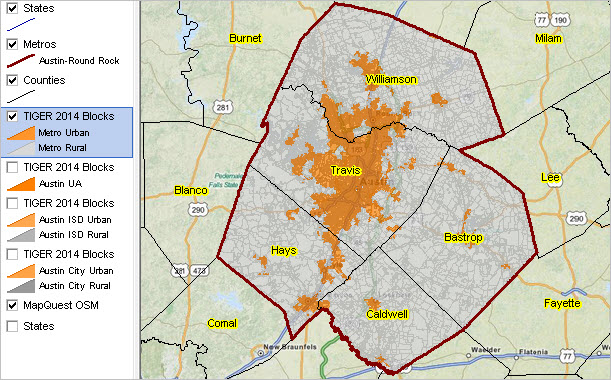
... using GIS tools & resources This section is companion to related Mapping Census Blocks section. It is focused on use of GIS tools and resources for visual, mapping and geospatial analysis of urban/rural patterns by census block. Applications illustrated here make use of the Austin-Round Rock, TX metro; similar views/applications may be developed for any county or metro. Members of the ProximityOne User Group ( join now, no fee) may use the GIS software and project files to create similar and more detailed views/analyses. Defining Urban/Rural Geography and Census Blocks For Census 2010, an urban area is a densely settled core of census tracts and/or census blocks that meet minimum population density requirements, along with adjacent territory containing non-residential urban land uses as well as territory with low population density included to link outlying densely settled territory with the densely settled core. To qualify as an urban area, the territory identified according to criteria must encompass at least 2,500 people, at least 1,500 of which reside outside institutional group quarters. Rural encompasses all population, housing, and territory not included within an urban area. A census block is the smallest geographic tabulation area and is classified as either all urban or all rural. More about census blocks. GIS Tools & GIS Project Resources The urban/rural patterns by census block GIS applications use the CV XE GIS software. To use the urban/rural patterns by census block GIS project, • install the Windows CV XE GIS softwareon your computer. • expand the GIS project fileset to c:\cvxe\1\ folder (User Group userid required). • start CV XE GIS. • open the GIS project c:\cvxe\1\austinblks1_tract.gis (File>Open>Dialog). About the Census Block Shapefile Each of the "TIGER2014 Blocks" layers shown in the map graphic legend panel uses the same Austin metro 5-county TIGER 2014 census block shapefile (TL_2014_48_TABBLOCK10_12420.SHP). The shapefile dBase file field attributes are shown in the scroll section below.
Note that the geographic area codes are Census 2010 vintage. For example, the CBSA code is 2009 vintage and does not reflect the February 2013 CBSA designations. Notable geographies potentially affected: city/place, school district, congressional district, state legislative district, PUMA. Developing GIS Project Applications for Other Areas The following notes summarize general steps to develop the above applications for any area. The 1) Census 2010 Summary File 1 (SF1) Urban/Rural Update Files and 2) TIGER 2014 census block shapefiles are packaged for download as a single zip file for each state. It is recommended that the "target" geographic area be one county or a set of counties (e.g., a metro) rather than an entire state.
1. Demographic Data Access and File Development
• Census 2010 Summary File 1 (SF1) Urban/Rural Update Files • Access the Census 2010 Summary File 1 Urban/Rural Update files via http://www2.census.gov/census_2010/04-Summary_File_1/Urban_Rural_Update/ • State by state folders contain a state zip file with the geoheader file, 48 data segments. • Expand the *geoheader segment only* from the state zip file of choice to the folder c:\cvxe\1\. - this is normally the last file listed in the zip file and has name ??geo2010.ur1 where ?? is the state USPS abbreviation. - after the file is expanded, rename ??geo2010.ur1 to ??geo2010.txt. • Create state SF1 geoheader dBase file: use CV XE Database>dBrowse: open sf1geo.dbf (download here and save to c:\cvxe\1\); User Group ID required) and import the geoheader file (??geo2010.txt). • Extract block records only - with dBrowse still open, set Filter to sumlev="100" (selecting only block level records) - use CopyTo (button below table) to copy the table to c:\cvxe\1\??sf1geo.dbf where ?? is the state USPS abbreviation. • Upon successful completion of this task, and for applications discussed here, the zip file and expanded files may be deleted. • Step 1 is complete. Close CV XE and restart when needed. 2. TIGER Census Block Shapefile • Access the TIGER 2014 census block shapefile via http://www2.census.gov/geo/tiger/TIGER2014/TABBLOCK/ • Download and open the state zip file with an unzip program. • Open state TIGER 2014 census block shapefile with CV XE File>Open>Dialog • Use CV XE File>Export Shapefile to reduce the scope of the statewide file to one county or a set of counties. - the Export Layer form appears; enter the county selection query in the "Query statement" edit box. - for example, the query statement for the Austin-Round Rock metro is: countyfp10='021' or countyfp10='055' or countyfp10='209' or countyfp10='453' or countyfp10='491' - click OK and you are prompted for the output file name. ... it is suggested that the output file name be structured like c:\cvxe\1\TL_2014_??_TABBLOCK10_12420.shp ... where ?? is the state FIPS code and "_12420" is added to the original state level shapefile name ... in this example, "12420" is the Austin-Roundrock CBSA code. - click OK and the export begins. • Step 2 is complete. Close CV XE and restart when needed. 3. Integrating SF1 Geoheader into Block Shapefile • Proceed after steps 1 and 2 completed. • Use CV XE Database>dBMerge • Open file 1 as dbf output from step 2; select all; move all. • Set key for file 1 as GEOID10 • Open file 2 as dbf output from step 1; select all; move all. • Set key for file 2 as state+county+tract+block • Click Merge button and wait for completion. 4. Add the Augmented TIGER Census Block Shapefile to GIS Project This completes the this subsection. ProximityOne User Group Join the ProximityOne User Group to keep up-to-date with new developments relating to metros and component geography decision-making information resources. Receive updates and access to tools and resources available only to members. Use this form to join the User Group. Support Using these Resources Learn more about accessing and using demographic-economic data and related analytical tools. Join us in a Data Analytics Lab session. There is no fee for these one-hour Web sessions. Each informal session is focused on a specific topic. The open structure also provides for Q&A and discussion of application issues of interest to participants. Additional Information ProximityOne develops geodemographic-economic data and analytical tools and helps organizations knit together and use diverse data in a decision-making and analytical framework. We develop custom demographic/economic estimates and projections, develop geographic and geocoded address files, and assist with impact and geospatial analyses. Wide-ranging organizations use our tools (software, data, methodologies) to analyze their own data integrated with other data. Follow ProximityOne on Twitter at www.twitter.com/proximityone. Contact us (888-364-7656) with questions about data covered in this section or to discuss custom estimates, projections or analyses for your areas of interest. | |||||||||||||||||||||||||||||||||||||||||||||||||||||||||||||||||||||||||||||||||||||||||||||||||||||||||||||||||||||||||||||||||||||||||||||||||||||||||||||||||||||||||||||||||||||||||||||||||||||||||||||||||||||||||||||||||||||||||||||||||||||||||||||||||||||||||||||||||||||||||||||||||||||||||||||||||||||||||||||||||||||||||||||||||||||||||||||||||||||||||||||||||||||||||||||||||||||||||||||||||||||||||||||||||||||||||||||||||||||||||||||||||||||||||||||||||||||||||||||
|
|