
|
|
|
.. did you know .. In 2020, the dependency ratio in the U.S. was 63.6 .. children under age 18 and adults age 65 and older for every 100 working-age person ages 18 to 64. The dependency ratio provides a rough approximation of economic dependency in a population by dividing the age dependent populations (children and adults age 65 and older), who are not generally expected to work) by the working-age population (ages 18 to 64). In 2010, the dependency ratio for the nation as a whole was 49.0 .. the working-age population is not keeping pace with growth in the older population. What is the dependency ratio in your areas of interest?. Find out using the VDA GIS tools .. see below. The dependency ratio is an important demographic measure. It informs policy-makers, planners, leaders, researchers and stakeholders is potentially at risk of possible non-sustainability. In most cases with larger population areas, high dependency ratio will show that employment is too low. A very high dependency ratio, particularly for areas of more than 15,000 population, of possible existing eroding tax base. Examining longer term trends, for example census to census, can highlight trending issues. Computing the Dependency Ratio .. see below. Using the Demographic Analytics Tool to Examine the Dependency Ratio The dependency ratio in 2020 was 58.10 for Phoenix, AZ compared to 65.65 for Maricopa County, AZ. The dependency ratio is presented as a part of the America's Demographic comparative analysis profile developed using the ProximityOne Demographic Analytics tool (DA). USe the DA tool to develop for more than 5 billion geographic comparative analysis profiles. Click the links below to view the comparative analysis narrative profile. .. the dependency ratio is shown lower down in the profile. Comparing scottsdale, AZ to Arizona The dependency ratio in 2020 was 69.23 for Scottsdale, AZ compared to 70.16 for Arizona Comparing Census Tract 04-013-2168.07 to Scottsdale, AZ The dependency ratio in 2020 was 80.86 for Tract 04-013-216807 compared to 69.23 for Scottsdale, AZ Comparing Congressional Community 04-01-001 to CD AZ 01 The dependency ratio in 2020 was 83.26 for Congressional Community 04-01-010 compared to 64.96 for CD AZ 01 Using VDAGIS Tools to Map & Geospatially Analyze the Dependency Ratio .. go to top Use the VDAGIS tools to learn the dependency ratio for your neighborhood(s) of interest. Use the VDA (Visual Data Analytics) GIS (Geographic Information System) tools to analyze the dependency ratio .. with the ready to use "Base" project. One option is to use the Web-based OpenVDA. Use Open VDA with only a Web browser, no fee, no registration, no login. Click here to start OpenVDA Click here for more information about OpenVDA An illustrative view showing dependency ratio for all congressional communities in Michigan CD 07 using OpenVDA. 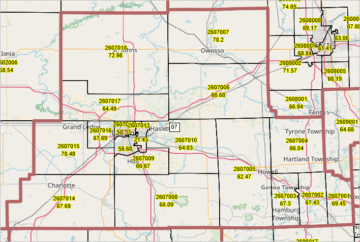 In the following graphics, the centroid location of ZIP code 85258 is shown as a blue triangle. Congressional Community 04-01-010 (cross-hatched) in context of Congressional District AZ 01 (bold brown boundary) 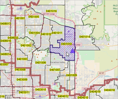 Scottsdale, AZ (cross-hatched) in context of Congressional District AZ 01 (bold brown boundary) 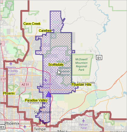 Census Tract 04-013-261807 (cross-hatched) 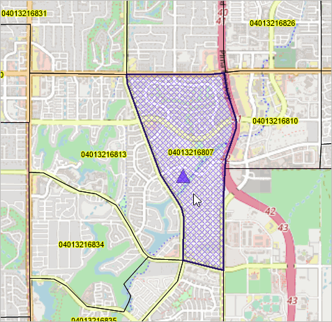 Computing the Dependency Ratio .. go to top Using the Census 2020 demographic profile data, the dependency ratio (DR) is computed using this equation: DR=100*((D001TPOP-D02118UP)+D02465UP)/(D02118UP-D02465UP) where the following field names from the VDA GIS projects Census 2020 DP1 shapefile/datasets are used: D001TPOP total population D02118UP population 18 years and over D02465UP population 65 years and over The Census 2020 data are used rather than the American Community Survey (ACS 2022 more recent program years for these reasons: 1. The ACS2022 data are centric to 2020 and subject to errors of estimation. .. at this point in time Census 2020 data are preferred to ACS 2022 5-year estimates. 2. Using decennial census data is preferred for longitudinal comparisons. For counties, metros, and the U.S., it would be preferred to use the Census sourced annual model-based estimates. Using the vintage 2023 estimates we will develop time series estimates using those data later in 2024. Diversity Ratio Field in VDA Base Project .. go to top The diversity ratio is precomputed in the Congressional Communities DP1 and Tracts DP1 layers/shapefiles. Using the VDAGIS GeoSelect/SiteAnalysis, the diversity ratio is dynamically computed and displayed for groupings of congressional communities and census tract layers using the DP1 layers/shapefiles (feature available May 2024). ProximityOne User Group .. go to top Join the ProximityOne User Group to keep up-to-date with new developments relating to metros and component geography decision-making information resources. Receive updates and access to tools and resources available only to members. Use this form to join the User Group. Support Using these Resources .. go to top Learn more about accessing and using demographic-economic data and related analytical tools. Join us in a Data Analytics Lab session. There is no fee for these one-hour Web sessions. Each informal session is focused on a specific topic. The open structure also provides for Q&A and discussion of application issues of interest to participants. Additional Information .. go to top ProximityOne develops geographic-demographic-economic data and analytical tools and helps organizations knit together and use diverse data in a decision-making and analytical framework. We develop custom demographic/economic estimates and projections, develop geographic and geocoded address files, and assist with impact and geospatial analyses. Wide-ranging organizations use our tools (software, data, methodologies) to analyze their own data integrated with other data. Follow ProximityOne on Twitter at www.twitter.com/proximityone. Contact ProximityOne (888-364-7656) with questions about data covered in this section or to discuss custom estimates, projections or analyses for your areas of interest. |
|
|