
|
|
|
-- resources to convert addresses to latitude and points on a map -- geospatial analyis of point-related data in context of demographics Geocoding is the process of converting individual addresses to latitude-longtitude, typically to show addresses as points or markers on a map using Geographic Information (GIS) tools. Geocoded data are often developed in the form of point shapefiles which are used in GIS projects for applications such as site analyses, depicting patterns of clients using a certain product or service or viewing locations in context of small area demographics. Geocoding involves minimally determining latitude-longitude based an address. It may also include assigning geographic codes (geocodes) such as the census block, block group or census tract containing the latitude longitude. It may also include assigning a code for the corresponding street/road line segment for the latitude-longitude point and assignment of the left or right side of the street road segment, TIGER/DMD Point to Shapefile This section is focused the ProximityOne CV XE GIS TIGER/DMD Point to Shapefile feature. The TIGEE/DMD Pt2Shp tool converts a latitude-longitude point file into a shapefile and adds the shapefile to an existing GIS project, showing the address locations on a map. The shapefile is permanently developed and available use with any GIS project and any software that can process a shapefile. K-12 Public Schools in Washington, DC Metro The 1,400 K-12 public schools shown as orange markers .. developing the underlying shapefile .. a focus of this section.  The TIGER/DMD Pt2Shp tool is designed to work with the Census Bureau Batch Geocoder. The Census Geocoder inputs a set of addresses and output that same set of address with the latitude-longitude encoded. While there are a number of rigidities and limitations to the Census Geocoder, it offers many unique and and important capabilities. • easy to setup the input file. • processes an address file moderately fast. • there is no fee. • uses TIGER files, producing geocoded results consistent with Census shapefiles and related data. Main limitations include: • does not convert assigned latitude-longitudes to a point shapefile. • match rate is only about 70%. • rigid input format does not allow for name or non address fields. Using TIGER/DMD Pt2Shp The TIGER/DMD Pt2Shp tool is a feature within the ProximityOne CV XE GIS. 1. Install CV XE GIS (version 21.1, 3/9/21 or later). Run the CV XE GIS installer .. requires User Group userid .. no cost, join here. .. after installed once, skip this step. 2. Start CV XE GIS (desktop icon) and select Tools>Pts2Shp. The Start-up View/form appears:  User Interface Settings and Controls • TIGER/DMD Geocoder -- open link to Census Geocoder. • About this Resource -- open link to this web page. • Geocoded Address Input File -- file generated by Census Geocoder. • New Shapefile -- shapefile to be generated by this application. • Create Shapefile button -- starts processing. .. using this operation assumes the Geocode Address Input file exists. • MaxRecs edit box -- enter number of records to process. Enter 0 for all records. Typically 0. • Augment Coding checkbox -- check if Census Geocoder no-matches are to be coded by supplemental coder. .. typically checked. • Geocode Years -- years for which state-county-tract-block geocodes are to be output Input to Census Geocoder (sch4700.csv) 110000500219,709 12th St SE,Washington,DC,20003 110000500328,3701 Hayes St NE,Washington,DC,20019 110000500377,770 Kenyon St NW,Washington,DC,20010 110000500456,3701 Hayes St NE,Washington,DC,20019 110000800338,4095 Minnesota Ave NE,Washington,DC,20019 110000800382,645 Milwaukee Pl SE,Washington,DC,20032 110000800422,2705 Martin Luther King Jr Ave SE,Washington,DC,20032 ... Geocoded Address Input File (sch47900_GeocodeResults.csv) 110000500219,"709 12th St SE, Washington, DC, 20003","Match","Exact","709 12TH ST SE, WASHINGTON, DC, 20003","-76.99025,38.881042","76230849","R","11","001","007100","2005" 110000500328,"3701 Hayes St NE, Washington, DC, 20019","Match","Exact","3701 HAYES ST NE, WASHINGTON, DC, 20019","-76.94913,38.902164","76232990","R","11","001","009602","3005" 110000500377,"770 Kenyon St NW, Washington, DC, 20010","Match","Exact","770 KENYON ST NW, WASHINGTON, DC, 20010","-77.0242,38.929993","76224176","L","11","001","003100","1000" 110000500456,"3701 Hayes St NE, Washington, DC, 20019","Match","Exact","3701 HAYES ST NE, WASHINGTON, DC, 20019","-76.94913,38.902164","76232990","R","11","001","009602","3005" 110000800338,"4095 Minnesota Ave NE, Washington, DC, 20019","Match","Exact","4095 MINNESOTA AVE NE, WASHINGTON, DC, 20019","-76.94696,38.89753","76239565","R","11","001","007803","1010" 110000800382,"645 Milwaukee Pl SE, Washington, DC, 20032","Match","Exact","645 MILWAUKEE PL SE, WASHINGTON, DC, 20032","-76.99675,38.84806","76232312","R","11","001","010400","3011" 110000800422,"2705 Martin Luther King Jr Ave SE, Washington, DC, 20032","No_Match" ... Shapefile Output
In the above, only the ID and ADDR fields were used as inputs; all others serviced in the Pts2Shp processing. /1 in this example, K-12 schools were used. The ID was selected as the Federal 12 character unique school ID code. in a Census Geocoder file input setup, it is often useful to use a value for possible later file merging. rather simply a sequence number. /2 this column is a profile of field values for a school *not coded* by the Census Geocoder /3 this column is a profile of field values for a school coded by the Census Geocoder School matched by supplemental geocdoer. 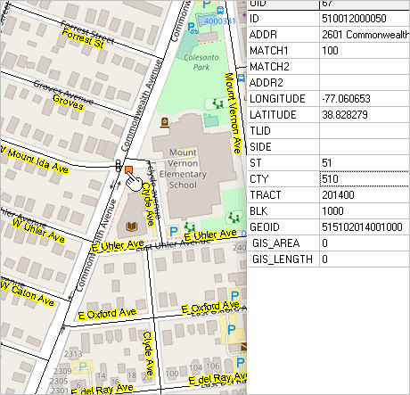 Street segment for school address matched by supplemental geocoder. 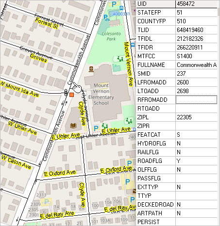 Processing ... If a "no-match" is found in a Census Geocodeed record, the supplemental geocoder codes the address. If the supplemnetal geocoder is used, a matchscore is entered in the Match1 field. 100 means exact; 60 means poor (60 typically means the centroid lat-lon of the ZIP code area). Using the TIGER/DMD Pt2Shp starts where the Census Geocoder ends. So, the first step is to use the Ceneus Geocoder and develop the geocoded file. We have developed a sample Census Geocoder input file consisting of approximately 1,400 address records. These are address data corresponding to K-12 public schools in the Washington, DC metro area. Processing this file with the Census Geocoder resulted in approximately 1,200 schools/address being coded. 236 school were not coded. Support Using these Resources Learn more about demographic economic data and related analytical tools. Join us in the Data Analytics Lab sessions. There is no fee for these Web sessions. Each informal session is focused on a specific topic. The open structure also provides for Q&A and discussion of application issues of interest to participants. ProximityOne User Group Join the ProximityOne User Group to keep up-to-date with new developments relating to geographic-demographic-economic decision-making information resources. Receive updates and access to tools and resources available only to members. Use this form to join the User Group. Additional Information ProximityOne develops geographic-demographic-economic data and analytical tools and helps organizations knit together and use diverse data in a decision-making and analytical framework. We develop custom demographic/economic estimates and projections, develop geographic and geocoded address files, and assist with impact and geospatial analyses. Wide-ranging organizations use our software, data and methodologies to analyze their own data integrated with other data. Follow ProximityOne on Twitter at www.twitter.com/proximityone. Contact ProximityOne (888-364-7656) with questions about data covered in this section or to discuss custom estimates, projections or analyses for your areas of interest. |
|
|