
|
|
|
-- examining neighborhoods, market areas and sales territories -- visual/geospatial analysis of location/address & demographic-economic data August 2019. Use tools described here to access block group data from ACS 2016, ACS2017, or ACS2018 in December 2019) using a no cost, menu driven tool accessing the data via API. Select from any of the summary statistic data. Save results as an Excel file or shapefile. Add the shapefile to a GIS project and create unlimited thematic pattern views. Add your own data. Topics in this section • 01 Objective Thematic Pattern Map View • 02 Install the CV XE GIS software • 03 Access/Download the Block Group Demographic-Economic Data • 04 Download the State by Block Group Shapefile • 05 Merge Extracted Data (from 03) into Shapefile (04) • 06 Add Shapefile to the GIS Project; Set Intervals • 07 Viewing Profile for Selected Block Group • 08 BG Demographics Spreadsheet • 09 Block Group Demographics GIS Project • 10 Why Block Group Demographics are Important 01 Objective Thematic Pattern Map View - Patterns of Median Household Income by Block Group; Alexandria, VA The following map view shows a main objective of this section ... step-by-step instructions to create this or similar map views for areas of interest. Alexandria, VA, a county equivalent, is part of the Washington, DC metro area. 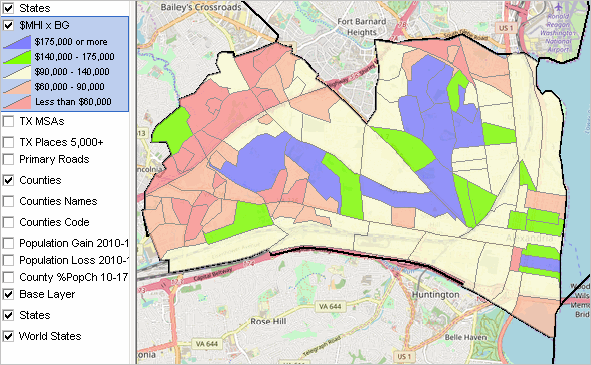 - Click graphic for larger view. - View developed using CV XE GIS. The $MHI (median household income) value intervals and color patterns are shown in the legend panel at the left of the map. It is easy to see patterns of economic prosperity for the 106 block groups comprising Alexandria. 02 Install CV XE GIS .. goto top Use this software to create maps such as the one above for any county in the U.S. Perform these operations and use the resulting maps and data in any manner. With Windows computer with Internet connection ... • Run CV XE GIS installer - take all defaults .. if already installed, run update installer for version dated before 11/06/18 • User Group ID required. Join here. No cost. • Done. All tools/resources ready. • The start-up view uses the GIS project that will be augmented with a block group thematic map. Adjusting the Map View to Alexandria, VA With CV XE GIS (CV) running and the default project open, proceed as follows. In the legend panel at the left, - uncheck Population Gain ... checkbox - uncheck Population Loss ... checkbox - check Base layer checkbox Zoom to County of Interest - on toolbar above map, click binoculars icon, the map view will be adjusted to Alexandria. - the Find Shapes form appears as shown below. - set all edit boxes and checkboxes as shown in the graphic and click the Find button. - Finally click the Revert button and close the form.  - the map view should appear as shown below. The boundary has been set to bold. 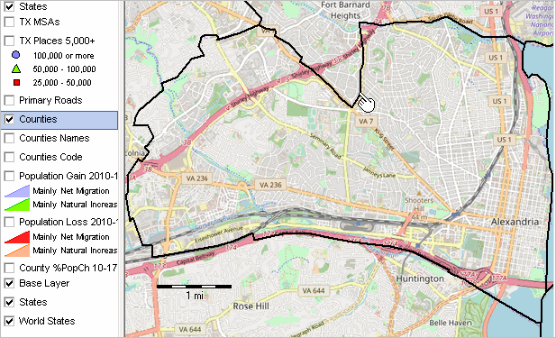 03 Access/Download the Block Group Demographic-Economic Data .. goto top ... using the CV XE GIS APIGateway The process of extracting selected ACS 2016 subject matter items and creating an Excel/CSV/DBF file is reviewed in this section. It could be a different year, different data source or geographic level. This process will extract data from the Web server and place it on your computer. See the CV XE GIS User Guide APIGateway section for more information. With CV XE GIS running, click File>APIGateway to start the APIGateway operation. The following view illustrates extracting the data for BGs in Alexandria, VA (county equivalent). 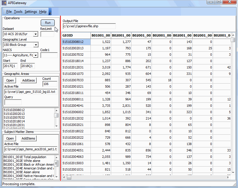 The grid to the right of the operations control panel on the left shows a row for each of 106 block groups in Alexandria. In the grid, see Census 2010 block group 515102008012 (code blue highlighted in top left cell) with total population (item B01001_001E from ACS 2016 5 year estimates) of 1,522 (top block group row, column 2). Each column corresponds to a subject matter item. See subject matter and GEOID codes in lists at left of grid. These lists were populated by reading the geocodes file and items file shown above the grid. Export data in the grid using File>SaveAs operation. 03.1. Control Settings/Operation .. to be further developed; this topic is covered in the every-Tuesday Data Analytics Web Sessions. 3.1.1. Dataset .. choose only ACS 2016 5 Year or ACS 2017 5 Year 3.1.2. RecLimit .. leave at 5 to test; set to blank/empty to run all areas in selection settings. 3.1.3. Output File .. the folder/name of the output file to be generated. 3.1.4. Geography List/Selections File - default: c:\cvxe\1\api_geo_51510_bg10.txt (included with installer) - a list of block group codes is located here: http://proximityone.com/blockgrousp.htm@table 3.1.5. Subject Matter Items List/Selections File - default: c:\cvxe\1\api_items_acs2016_set1.txt (included with installer) - subject matter fields names are located here 3.1.6. Click Run button to process. Main results of this step: 1 - development of the shapefile c:\cvxe\1\apinewfile.shp .. named in the edit box above the grid. .. this is a point shapefile; for an area shapefile, proceed with section 04. .. a point shapefile that may be added to the GIS project and view. 2 - development of the file c:\cvxe\1\apinewfile.dbf (part of the shapefile) .. contains the extracted block group demographic data. .. one row/record for each block group in the geography list file. .. one column/field for each subject matter item in the subject matter list file. View Illustrating Use of the Point Shapefile Developed in Step 03 - markers are located at block group internal points 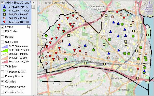 04 Download the State by Block Group Shapefile .. goto top ... using the CV XE GIS GeoGateway See the CV XE GIS User Guide GeoGateway section for more information. With CV XE GIS running, click File>GeoGateway to start the GeoGateway operation. The following view illustrates downloading the VA BG shapefile.  View with BG shapefile  Main result of this step: .. obtaining the block group shapefile c:\cvxe\1\cb_2017_51_bg_500k.shp. 05 Merge Extracted Data (from Step 2) into Shapefile (from Step 3) .. goto top .. this step requires CV XE GIS Level 1 or higher .. Use File>Database>dBMerge to start merge operation. 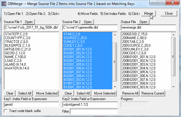 Steps for the merge operations are: • Open Source File 1 (the dbf from Step 4) • Open Source File 2 (the dbf from Step 3) • Select all items in Source File 1; Click Move Selected • Select all items (except GEOID) in Source File 2; Click Move Selected • Set the Key 1 value -- GEOID • Set the Key 2 value -- substr(geoid,1,12) • Click Merge button (upper right in form) • Wait for merge to complete and allow overwrite • The shapefile now includes the extracted subject matter data. Close the dBMerge form if open. Main result of this step: .. integration of the demographic data into shapefile c:\cvxe\1\cb_2017_51_bg_500k.shp 06 Add Shapefile to the GIS Project; Set Intervals.. goto top .. this step requires CV XE GIS Level 1 or higher .. with CV XE GIS running use File>Add Layer>Dialog and add shapefile from Step 5 Navigate to your application area zoom tool/pan-drag tool Dbl-click your new layer to start the layer editor. • Modify layer name. • Set intervals similar to the way that intervals are set for the MHI by BG layer. • Use File>SaveProjectAs and save the project with name c:\cvxe\1\mappingbg2.gis. Development steps are now complete. Main result of this step: .. completed map view and ability to perform extended mapping and geospatial analysis with this GIS project 07 Viewing Profile for Selected Block Group .. goto top With CV XE GIS running, zoom in and select identify tool. Click on block group as shown in next graphic to view mini-profile for that area. 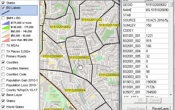 08 BG Demographics Spreadsheet .. goto top With CV XE GIS running, use File>Database>dBrowse to start dBrowse. Click Open button and open the file C:\cvxe\1\cb_2017_51_bg_500k.dbf Spreadsheet grid shows block group records as shown in graphic below. • All columns & data items extracted • Click CopyTo button to export to CSV/text file 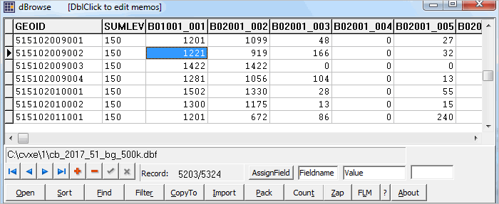 09 Block Group Demographics GIS Project .. goto top Some might like to use the GIS project culminating all of the steps in this section. Also, those not using CV XE GIS Level 1 or higher (thus not having database features) can use the GIS project with the User Group version to see how operations work. To use this GIS project, unzip http://proximityone.com/cv/1/cvxe_us1_alexbg.zip to the folder c:\cvxe\1. .. requires User Group ID .. this GIS project is a part of the Mapping Statistical Data program. The start-up view is shown in graphic below. 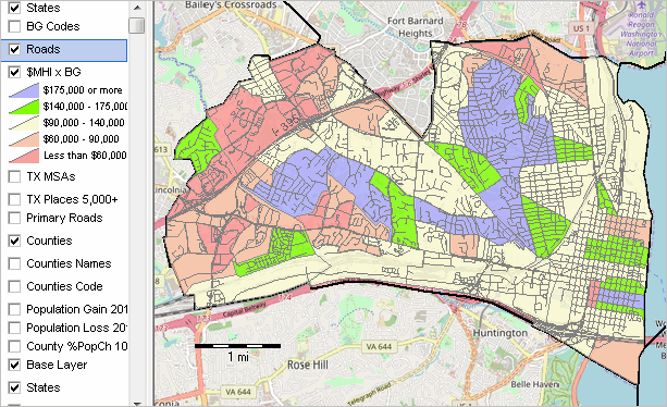 10 Why Block Group Demographics are Important .. goto top Demographic-economic patterns and characteristics can often be "masked" when using larger geographic areas such as counties and metros. Using data for small area geography such as census tracts and can help identify clusters and areas of interest. Now, demographic-economic data for block groups (217,000 areas averaging 1,200 population covering the U.S. wall-to-wall) are tabulated annually from the American Community Survey (ACS). There are hundreds of subject matter items updated annually. Without specialized tools, it is very difficult to navigate through the maze of small area data that are available and make effective use of these data for analysis and decision-making. How many potential customers are there for a store at a specific location? Use BG level demographics to get insights into the number and type of customers, household characteristics, in a service area. See related Business Data Analytics section. How to determine characteristics of households and children located in a school attendance zone (SAZ)? Determine the intersecting BGs with the SAZ. Aggregate BGs attributes within the SAZ(s). Add a SAZ shapefile layer to a GIS project. Use the combination of API tools and GIS tools described in this section to visually and geospatially analyze demographic-economic characteristics of block groups. Covering the U.S. wall-to-wall and averaging 1,200 population, block groups are the smallest geographic tabulation area for data from the American Community Survey (ACS 5-year estimates). Block group (BG) data are also available from Census 2010 Summary File 1 (SF1) for the same block group area geography. ProximityOne User Group Join the ProximityOne User Group to keep up-to-date with new developments relating to metros and component geography decision-making information resources. Receive updates and access to tools and resources available only to members. Use this form to join the User Group. Support Using these Resources Learn more about accessing and using demographic-economic data and related analytical tools. Join us in a Data Analytics Lab session. There is no fee for these one-hour Web sessions. Each informal session is focused on a specific topic. The open structure also provides for Q&A and discussion of application issues of interest to participants. Additional Information ProximityOne develops geodemographic-economic data and analytical tools and helps organizations knit together and use diverse data in a decision-making and analytical framework. We develop custom demographic/economic estimates and projections, develop geographic and geocoded address files, and assist with impact and geospatial analyses. Wide-ranging organizations use our tools (software, data, methodologies) to analyze their own data integrated with other data. Follow ProximityOne on Twitter at www.twitter.com/proximityone. Contact us (888-364-7656) with questions about data covered in this section or to discuss custom estimates, projections or analyses for your areas of interest. |
|
|