
|
|
|
-- Helping Americans Make Their Voices Heard by Congress Making your voice heard to Congress on matters that affect you ... There are 162 congressional communities (CCs) that subdivide Arizona's nine 118th congressional districts (CDs). Nesting within CDs, CCs are typically range from 40,000 to 60,000 population. • See this example of CC 14 in Arizona CD 118 district 1. • Find your Arizona CC .. see details below. What we do ... ProximityOne develops and uses tools and data to provide fact-based, independent, non-partisan decision-making information to stakeholders on a wide range topics/issues. These areas include congressional districts, and other legislative entities, with regard to their geographic, demographic and economic characteristics and trends. E-mail us or call (888-364-7656) with questions or for help or use the chat/message-us in the lower right on this page. 118th Congress Congressional Districts The U.S. 435 118th Congressional Districts (Jan 3, 2023 to Jan 3, 2025) have an average population of approximately 763,000 population, larger than three states (see in table). Boundaries for the 118th Congressional Districts (CDs) are now being established by state redistricting based on Census 2020. Elections in November 2022 will generally determine incumbents and party for each 118th CD. Congressional Communities As a resident, constituent, of a congressional district, how do you make your voice heard on key issues affecting you, your household and your local living environment in Congress? Congressional Communities, subdivisions of Congressional Districts, can help Americans better have their voice heard by Congress. Congressional communities are developed by assembling 2020 census blocks and block groups using the ProximityOne CV XE GIS software and state GIS projects. Congressional districts are sub-divided into CCs, sets of contiguous blocks/block groups, that are typically around 40,000 population based on a range of socioeconomic, geopolitical features, geographic and other factors. A set of Census 2020 and American Community Survey demographics are developed for each CC. These demographics help CC stakeholders better understand characteristics and needs of their CCs and other CCs. Unlike census tracts, averaging 4,000 population, CCs nest within CDs and better reflect neighborhood-plus characteristics. Unlike cities, CCs include rural and suburban areas and sub-divide larger cities. A Closer look at Congressional Communities .. goto top This section illustrates how congressional communities relate to congressional districts in Arizona. Similar features and developments apply to all states. Where is my Congressional Community? .. goto top You can use the VDA Web GIS to locate/view 2010-based CC based on an address. Details on this are provided below. Many states do not yet have final 118th CD boundaries, possibly some not final until 2023. Soon this page will updated with the current status of 2020-based CCs. Arizona 118th Congressional Districts .. goto top There are 9 Arizona 118th CDs, unchanged from the 116th CDs based on Census 2010. However, the boundaries of the 118th CDs differ from the 116th CDs. Click graphic for larger view. 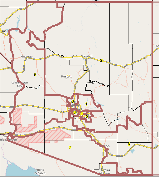
Arizona Congressional Community 04-01-014 in Context .. goto top The following view shows CC 04-01-014 in context with the city of Scottsdale (cross-hatched) see pointer in southern part of city) and 118th CD 1 (red label). The select tool is used to click on the CC and display a demographic profile. The profile shows that this CC had a Census 2020 total population of 58,359 and related demographics. 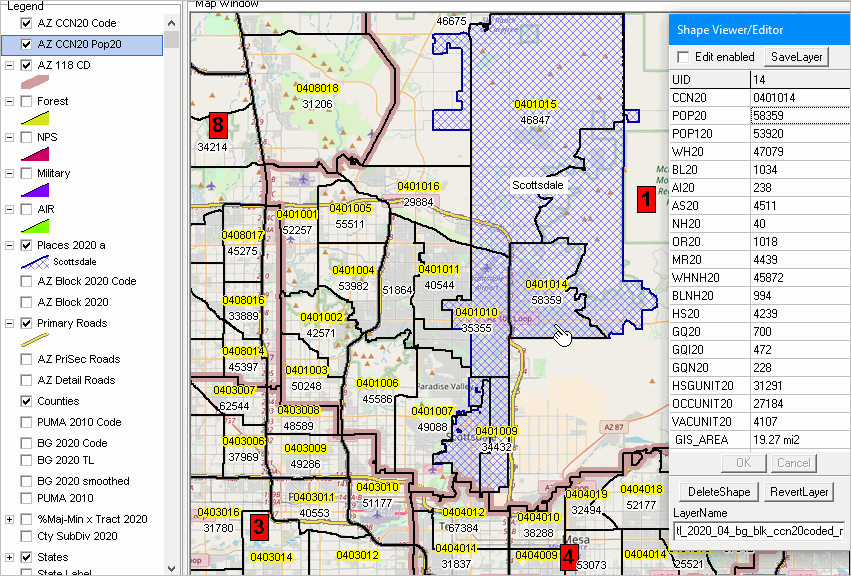
A CC Focus: Arizona Congressional Community 04-01-014 .. goto top The following view shows a zoom-in to CC 04-01-014. This view also shows component block groups with black boundaries. The select tool is used to click on a block group and display a demographic profile. The profile shows that this block group had a Census 2020 total population of 1,567 and related demographics. 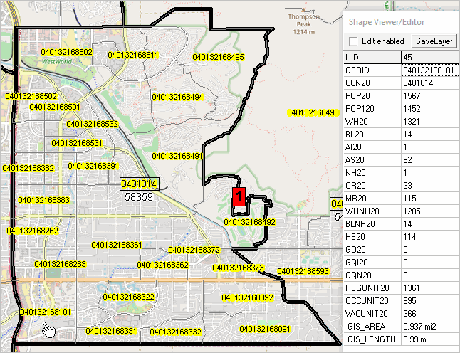
Examining All CCs in a CD .. goto top The following graphic shows another way to examine how the CCs in a CD relate to each other. This tabular view shows all CCs in AZ CD 1 as rows with demographics arrayed across columns. CC 0401014 is highlighted in the left column. The pointer shows the Census 2020 Hispanic population (of any race) is 4,239. Click graphic for larger view. Create similar views using VDA Web GIS. See more below. 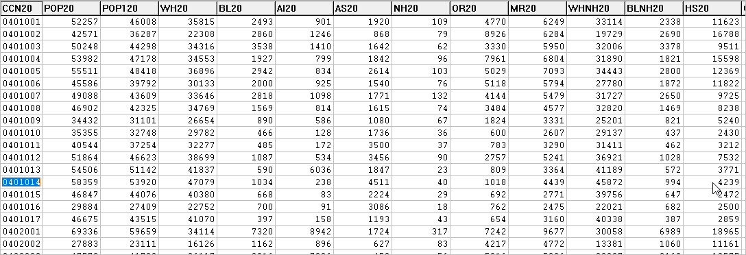
Locating/Examining Congressional Communities Using VDA Web GIS .. goto top Use the VDA Web GIS to examine the 118th CDs in context of other geography and subject matter. The Visual Data Analytics (VDA) Web GIS VDA has been developed by Warren Glimpse/ProximityOne/Alexandria, VA USA and Takashi Hamilton/Tsukasa/Osaka, Japan. All that is required to use VDA is a Web browser. VDA uses the same core structure as the Windows desktop VDA Desktop. Start VDA: https://vdagis.com Login then select project: Arizona SRDMI .. map view appears Change active layer (upper left dropdown) to 118th Congressional Districts (select that layer name) In the legend panel, check on the 118th Congressional Districts layer Optionally check-off the AZ Tract $MHI Pattern layer. Optionally Find County (above map window) select Maricopa County, AZ. Click far right button below map window (Query/Table) .. grid appears below map Click Select Field button below table/grid .. check selected items and close form Table populates with Arizona 118th CDS. 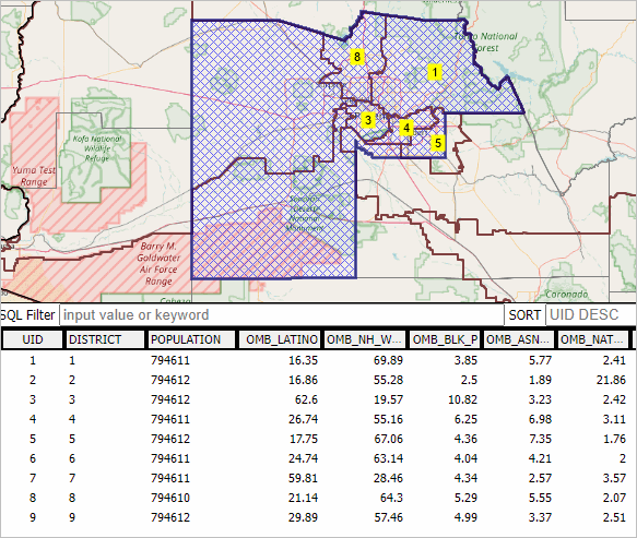 Support Using these Resources .. goto top Learn more about accessing and using demographic-economic data and related analytical tools. Join us in a Data Analytics Lab session. There is no fee for these one-hour Web sessions. Each informal session is focused on a specific topic. The open structure also provides for Q&A and discussion of application issues of interest to participants. Additional Information .. goto top ProximityOne develops geodemographic-economic data and analytical tools and helps organizations knit together and use diverse data in a decision-making and analytical framework. We develop custom demographic/economic estimates and projections, develop geographic and geocoded address files, and assist with impact and geospatial analyses. Wide-ranging organizations use our tools (software, data, methodologies) to analyze their own data integrated with other data. Follow ProximityOne on Twitter at www.twitter.com/proximityone. Contact us (888-364-7656) with questions about data covered in this section or to discuss custom estimates, projections or analyses for your areas of interest. |
|
|