
|
|
|
-- examining demographic change: Census 2010-Census 2020 -- expanding insights through data analytics February 2024 .. cities/places, areas of population concentration, are important and of interest for many reasons. See more about places. The number of U.S. cities/places changed from 29,514 (Census 2010) to 31,617 (Census 2020). The total population of these places changed from 228,457,238 in 2010 to 249,755,152 in Census 2020. Use the interactive table below to view, rank, compare demographic attributes of cities/places of interest. City/Place Data Analytics • 2010-2020 Demographics Interactive table below • How are city(s) changing since 2020? See your cities of interest • Map, geospoatially analyze city(s) Click to start OVDAW .. examine city/places using Open VDA Web GIS .. about .. using a browser, nothing to install • Demographic-Economic Data Extraction (DEDE) tool .. build you own custom datatsets • Interpretative Analyses & Studies An Illustrative Example .. goto top The following view illustrates use of VDA Web GIS to map/visually examine the city of Fresno, CA (blue cross-hatched area). Stakeholders can view cities/places of interest in context of other places, other types of geography, and wide ranging subject matter. See your address coded locations as markers in context of these political/statistical geography. 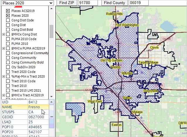 Using the interactive table below, the following graphic shows that Fresno city is the 5th largest city in California as of 2020. It is easy to access these data and view attributes of one city in context of others. 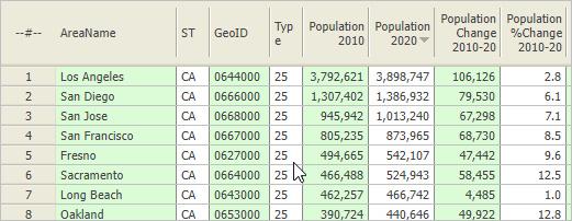 Examining the City Demographics as a Profile .. goto top Use VDA Web GIS to easily create a profile for any city/place. View this Excel file that has been developed by just clicking on the city in the map view. The following graphic (in a scroll section) shows the upper portion (mainly Census 2010) of the XLS display; the Census 2020 data, not shown in the graphic, are included in the XLS file with a structure similar to the Census 2010 upper section. 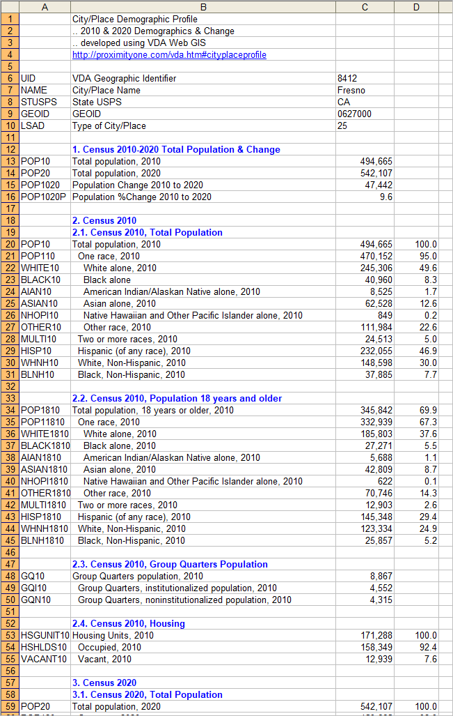 More About Cities/Places .. goto top Places, areas of population concentration, are important for many reasons. Areas are places of population concentration, it is important to know how they are situated with services by institutions such as hospitals and healthcare facilities, educational facilities, banking services, and overall government operations. Most places have been established for many decades. Smaller places have older core area residential structures and often degrading commerical structures, but delightful in other respects. The infrastructure serving places is often not well maintained. By knowing how a place/places are changing provides insights into trending needs. Diversity has become an increasing topic of interest/importance and plays a key role. A city/place boundary might be thought of as a collector geography; each city/place is comprised of a set of census blocks, block groups and census tracts. The demographic characteritics of a city is often best analyzed in terms of these "component geographies." These sub-place areas often vary widely from the places characteristics and trends relative to the place overall. Cities/Places are geographies/areas that include Incorporated Places and Census Designated Places (CDPs). Incorporated Places are legally bounded entities such as cities, boroughs, towns, or villages depending on the state. There are almost 22,000 incorporated places based on Census 2020. Census Designated Places (CDPs) are "statistically defined entities" (by the Census Bureau and local agencies) that are unincorporated community, concentration of population, housing, and commercial structures, identifiable by name, but not within an incorporated place. CDP's have a LSAD (Legal/Statistical Area Description) code of 57. These codes can be useful when analyzing types of places using VDA. For Census 2020, there are 10,195 CDPs and 21,993 Incorporated Places/cities. City/Place Demographics Census 2010-Census 2020 & Change Interactive Table .. goto top Interactive table; click column header to sort; usage notes below table. Table may initially require a few seconds to load. See notes about how these data have been developed. Table includes all Census 2020 cities/places in states & D.C. See related Interactive Tables Main Page Table Usage Click ShowAll button between queries. Data were extracted using the Census Bureau API and the ProximityOne DEDE tool. Data presented in the table were first developed for all counties based on the Census 2020 P.L. 94-171 data. As a result, all geocode and name references are as of 2020. The same set of subject matter was extracted from the Census 2010 SF1. Census 2010 data were then merged with the Census 2020 data based on the place geocode match key. A few place names or codes may have chnaged bwteeen 2010 and 2020. Some places did not exist as of 2010. Some 2010 places have changed boundary since 2010. The value -999 appears in the 2010-20 change column for places where the Census 2010 population is zero. Towns, in New England state, and Minor Civil Divisions (MCDs), in many midwestern states, have geographic definitions (both administrative subdivisions of counties) that are typically different from incorporated cities and census designated places (both places of population concentration). Towns and MCDs (ake subcounty areas) are generally not included in the table. Subject Matter Items Included in Above Table Items/columns presented in the
- Name
- St - GeoId - Type of city/place - Population 2010 - Population 2020 - Population Change 2010-20 - Population %Change 2010-20 -- Census 2010 -- - Population One Race 2010 - White alone 2010 - Black alone 2010 - AIAN alone 2010 - Asian alone 2010 - NHOPI alone 2010 - Other alone 2010 - Multi Race 2010 - White NonHisp 2010 - Black NonHisp 2010 - Hispanic (any race) 2010 - Population 18+ 2010 - Population 18+ One Race 2010 - White alone 18+ 2010 - Black alone 18+ 2010 - AIAN alone 18+ 2010 - Asian alone 18+ 2010 - NHOPI alone 18+ 2010 - Other alone 18+ 2010 - Multi Race 18+ 2010 - White 18+ NonHisp 2010 - Black 18+ NonHisp 2010 - Hispanic 18+ (any race) 2010 - Group Quarters 2010 - Group Quarters Inst 2010 - Group Quarters NonInst 2010 - Total Housing Units 2010 - Occupied Units 2010 - Vacant Units 2010 -- Census 2020 -- - Population One Race 2020 - White alone 2020 - Black alone 2020 - AIAN alone 2020 - Asian alone 2020 - NHOPI alone 2020 - Other alone 2020 - Multi Race 2020 - White NonHisp 2020 - Black NonHisp 2020 - Hispanic (any race) 2020 - Population 18+ 2020 - Population 18+ One Race 2020 - White alone 18+ 2020 - Black alone 18+ 2020 - AIAN alone 18+ 2020 - Asian alone 18+ 2020 - NHOPI alone 18+ 2020 - Other alone 18+ 2020 - Multi Race 18+ 2020 - White 18+ NonHisp 2020 - Black 18+ NonHisp 2020 - Hispanic 18+ (any race) 2020 - Group Quarters 2020 - Group Quarters Inst 2020 - Group Quarters NonInst 2020 - Total Housing Units 2020 - Occupied Units 2020 - Vacant Units 2020 Support Using these Resources .. goto top Learn more about demographic economic data and related analytical tools. Join us in a Data Analytics Lab session. There is no fee for these Web sessions. Each informal session is focused on a specific topic. The open structure also provides for Q&A and discussion of application issues of interest to participants. ProximityOne User Group .. goto top Join the ProximityOne User Group to keep up-to-date with new developments relating to geographic-demographic-economic decision-making information resources. Receive updates and access to tools and resources available only to members. Use this form to join the User Group. Additional Information .. goto top ProximityOne develops geographic-demographic-economic data and analytical tools and helps organizations knit together and use diverse data in a decision-making and analytical framework. We develop custom demographic/economic estimates and projections, develop geographic and geocoded address files, and assist with impact and geospatial analyses. Wide-ranging organizations use our software, data and methodologies to analyze their own data integrated with other data. Follow ProximityOne on Twitter at www.twitter.com/proximityone. Contact ProximityOne (888-364-7656) with questions about data covered in this section or to discuss custom estimates, projections or analyses for your areas of interest. |
|
|