
|
|
|
America's Cities & Places Demographic Characteristics & Trends
View a city of interest in context of other cities, county, census tracta using the Visual Data Analytics (VDA) Web GIS With any browser, click here to start VDA. Consider a vist to Scottsdale, AZ, follow these steps when VDA starts:: • Click the Find ZIP in upper left corner .. map window zooms to ZIP code. • In the legend panel at left check/uncheck these checkboxes: - uncheck the Metros/MSA, - below that, check on the Cities Name and Cities layers - scroll down in legend panel and uncheck World by Country. - below that, check on the Open Street Maps layer. Your view should now look like this (the cross hatched area is the ZIP code area): .. ZIP code 85258 in context of Scottsdale, AZ 
America's Cities & Places, Large & Small Of the nation's 327.2 million people, an estimated 206.0 million (62.9%) live within an incorporated place. Of approximately 19,500 incorporated places, about 76 percent had fewer than 5,000 people and nearly 50 percent had fewer than 1,000 people. Examine characteristics of individual city population trends and compare cities in states, regions and peer groups using the interactive table below. There is more in the interactive table. It also includes another 10,000 Census Designated Places (CDPs) - places of population concentration having no city government. Create Side-by-Side Spreadsheet Profiles • Select any set of cities • See details and examples below Cities by Population %Change -- 10,000 Population or More The following view shows cities with 2018 population of 10,000 or more. The marker color shows population percent change during 2010-2018. It is easy to see regionally how city population is changing. Click graphic for larger view; expand window to full screen. 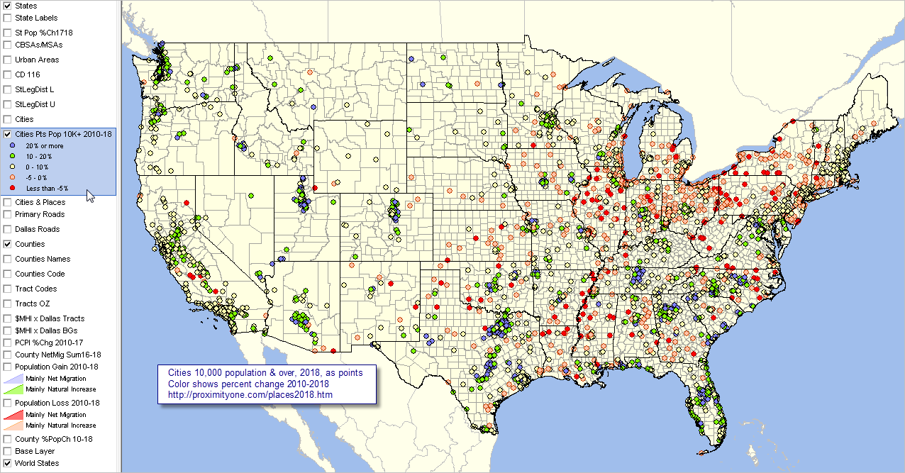 - View developed using the CV XE GIS software. City/Place Demographics in Context & Related Data • State & Regional Demographic-Economic Characteristics & Patterns .. individual state sections with analytical tools & data access to block level • Metropolitan Area Situation & Outlook .. continuously updated characteristics, patterns & trends for each/all metros • ACS 5-year estimates .. related City/Place Demographic-Economic Interactive Tables .. General Demographics ... Social ... Economic ... Housing Characteristics • U.S. by County 2010-2019 Estimates • U.S. by Metro 2010-2019 Estimates Using the Interactive Table Use the interactive table below view, rank, query and compare cities of interest. View the list of cities with the largest 2019 population by dbl-clicking the header cell "Population 7/1/2018" in the table. Place a state query on the table to select cities in a state of interest and click the header cell "Population 7/1/2018" to view cities in that state ranked by size. Choose other columns to view other relationships. City Population Estimates & Trends Interactive Table: 2010-2019 See usage notes below ranking table. See related interactive tables. Rank on any column by clicking column header; use mouse-over on column header to view description of item. Click ShowAll button between queries. Note: all "places", incorporated and census designated places (CDP), are shown in the table. .. population data shown in the table are estimates based on Census Bureau population estimates program (PEP). .. PEP does not develop estimates for CDPs, CDP population values show in the table as -1. .. view demographic-economic characteristics for *any place* by clicking the link in the Profile column. .. those profile estimates are based on ACS 2019 5-year estimates centric to mid 2017. .. use buttons below table for selective columns view. Usage Notes • Click ShowAll between queries/filters. • Use left-most column to select by state. • FindName button; click ShowAll button first .. click FindName button to search column 1 for text in edit box. .. text entered in edit box is case sensitive. .. partial names are okay to use. .. click with default value to view all rows with "Scottsdale, AZ" (no quotes) Selected columns buttons • Pop Cols - click to view the set of all years by population 2010-19. • Population Min & Max> button .. click to show only peer group counties based on values in min and max edit boxes. .. enter the minimum 2019 population in the left edit box. .. enter the maximum 2019 population in the right edit box. • Click ShowAll between queries/filters. Using the U.S. by Cities Shapefile with Integrated Demographics .. goto top The U.S. by city/place shapefile is developed/updated annually as part of the Census Bureau TIGER/Line digital map database. It is the most authoritative and up-to-date source of annually updated incorporated city boundaries. ProximityOne integrates the city population annual time series estimates into the smoothed version of the national U.S. by place shapefile. Users of the CV XE GIS Level 2 or Level 3 software with an active support license may download the U.S. by place shapefile at no fee. The U.S. by place shapefile with integrated estimates may be used with any software that can process shapefiles. About These Data -- goto top City and sub-county population estimates are developed annually by the Census Bureau. The model-based estimates are normally released in June (e.g., 7/1/20 estimates released in June 2021). Population estimates for incorporated places the city with boundaries as defined as of January 1, 2019. Incorporated Cities/Places The legal designations, powers, and functions of incorporated places vary from state to state. Incorporated places include cities, towns (except in New England, New York, and Wisconsin where towns are county administrative subdivision), boroughs (except in Alaska where boroughs are treated as equivalents of counties and New York where five boroughs comprise New York City) and villages. Incorporated places can cross both county boundaries. ProximityOne assigns each city to a county and CBSA/metro (if located in a CBSA). The county is assigned using a U.S. by city point shapefile. The county is assigned to a city for the county that contains the city point (internal area latitude-longitude). The CBSA code is assigned based on the county code (all CBSAs are comprised of one of more counties). Data in Excel/Database Structure Data shown in the table are available in the form of Excel, CSV or DBF structure. Users of the shapefile (described above may use the dbf part of the shapefile for tabular/spread-type analysis and to integrate with other data. Comparing Cities Side-by-Side -- goto top With CV XE GIS running using the US1 GIS project open, compare any number of cities side-by-side and save the results in a spreadsheet file. Item Descriptions for CV XE GIS Comparative Analysis -- scroll section
- GeoObject ID
Item names starting with "ACS17" are American Community Survey 5-year estimates
(ACS 2017). Geographic items based on
2018 TIGER/line data. Other items based on
Census 7/1/18 vintage model-based estimates released May 2019 (included in above table).- City Name - City Name with type - State USPS - Place Code - County Code - Metro Code - Principal City Status - Type of City - Land Area, SqMi - Water Area SqMi - Internal point, latitude - Internal point, longitude - Population Census 2010 - Population Base 2010 - Population 7/1/2010 - Population 7/1/2011 - Population 7/1/2012 - Population 7/1/2013 - Population 7/1/2014 - Population 7/1/2015 - Population 7/1/2016 - Population 7/1/2017 - Population 7/1/2018 - Pop Chg 2010-18 - %Pop Chg 2010-18 - Pop Chg 2017-18 - %Pop Chg 2017-18 - ACS17POP - Total population - ACS17CVAP - Citizen voting age populaiton - ACS17HS - Percent High School Graduate (25 yrs+) - ACS17COLL - Percent College Graduate (25 yrs+) - ACS17MHI - Median Household Income - ACS17AHI - Mean Household Income - ACS17MFI - Median Family Income - ACS17AFI - Mean Family Income - ACS17PCI - Per capita income - ACS17HU - Housing units - ACS17HUO - Occupied housing Units (households) - ACS17HUV - Vacant housing units - ACS17HUOVR - Owner occupied vacancy rate - ACS17HURVR - Renter occupied vacany rate - ACS17HUOO - Owner occupied units - ACS17HURO - Renter occupied units - ACS17MHV - Median housing value - ACS17MRENT - Median rent - Area - Perimiter The following applications illustrate using the CV XE GIS tools to compare cities (an optional view created with CV XE GIS query settings on the cities layer): Example 1: Chicago area: Naperville & Bollingbrook: 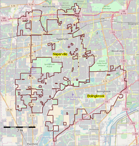 Illustrative results; comparing Naperville & Bollingbrook -- scroll section -- compare any number, anywhere in the U.S.
Example 2: Florida: Orlando & Tampa (green fill pattern; counties with white labels): 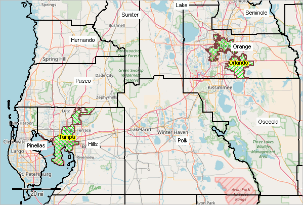 Illustrative results; comparing Orlando & Tampa -- XLS file -- compare any number, anywhere in the U.S. -- click to view Orlando & Tampa profile Example 3: Texas: Frisco & McKinney (green fill pattern; counties with white labels): 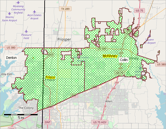 Illustrative results; comparing Frisco & McKinney -- XLS file -- compare any number, anywhere in the U.S. -- click to view Frisco & McKinney profile Example 4: Colorado: Boulder & Fort Collins (green/blue fill patterns; counties with white labels): 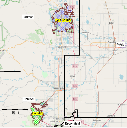 Illustrative results; comparing Boulder & Fort Collins - XLS file -- compare any number, anywhere in the U.S. -- click to view Boulder & Fort Collins profile Example 5: California: Huntington Beach, Costa Mesa, Newport Beach (green/blue/orange fill patterns; counties white labels): 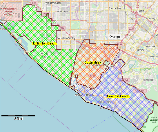 Illustrative results; comparing Huntington Beach, Costa Mesa, Newport Beach - XLS file -- compare any number, anywhere in the U.S. -- click to view Huntington Beach, Costa Mesa, Newport Beach profile Support Using these Resources .. goto top Learn more about demographic economic data and related analytical tools. Join us in a Data Analytics Lab session. There is no fee for these Web sessions. Each informal session is focused on a specific topic. The open structure also provides for Q&A and discussion of application issues of interest to participants. ProximityOne User Group .. goto top Join the ProximityOne User Group to keep up-to-date with new developments relating to geographic-demographic-economic decision-making information resources. Receive updates and access to tools and resources available only to members. Use this form to join the User Group. Additional Information .. goto top ProximityOne develops geographic-demographic-economic data and analytical tools and helps organizations knit together and use diverse data in a decision-making and analytical framework. We develop custom demographic/economic estimates and projections, develop geographic and geocoded address files, and assist with impact and geospatial analyses. Wide-ranging organizations use our software, data and methodologies to analyze their own data integrated with other data. Follow ProximityOne on Twitter at www.twitter.com/proximityone. Contact ProximityOne (888-364-7656) with questions about data covered in this section or to discuss custom estimates, projections or analyses for your areas of interest. |
|
|