
|
|
|
Austin, TX GIS & GeoDemographic Analysis Applications
August 2019 .. integrate/analyze your data with other data in your secure environment .. illustrative applications .. using Geographic Information System (GIS) and geodemographic tools and data focused on Austin, Texas area. This section is a companion to the Using GIS and GeoDemographics online course. Views presented here illustrate use of the digital map database and GIS project used in the course. Participants learn how to use this GIS project and develop their own similar GIS project for areas of interest. Policy-makers need these tools and data. Bankers and businesses can better assess markets and competitive position. Expand your ability to examine Census 2020 data and participate in redistricting. Using GIS & GeoDemographics
Whether you are a
GIS
user or not yet using GIS, you can benefit from our self-paced, online course
Using GIS & GeoDemographics.
Learn more about using wide-ranging geography and subject matter to develop reference and thematic maps.
Develop skills to perform site analysis, develop site reports, perform geospatial analysis.
Integrate any/all of the TIGER data in to your GIS projects.
See additional information.
Contents • 01. Travis County & Austin Area in Context of Texas & Region • 02. Austin Metro Area by County • 03. Urban Areas • 04. Public Use Microdata Data Area (PUMS) - custom demographic estimates • 05. Patterns of Economic Prosperity by Tract in Travis County, TX Area< • 06. Patterns of Economic Prosperity by Block Group in Travis County, TX Area • 07. Integrating Block Group, Roads, $MHI • 08. ZIP Code Areas Integrated with Block Group x $MHI, Roads • 09. Austin Area School Districts • 10. 116th Congressional Districts in the Travis County, TX Area • 11. Travis County, TX Census Blocks • 12. Travis County Area State Legislative Districts - Lower • 13. Travis County, TX Election Precincts with %Hispanic by Block Group Travis County & Austin Area in Context of Texas & Region Graphic below shows four largest Texas metros. Travis county, located in the Austin metro and home to the city of Austin, is shown with green fill pattern. 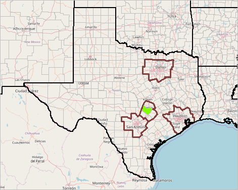 - view developed using ProximityOne CV XE GIS and related GIS project. Austin Metro Area .. goto top Graphic below shows a zoom-in to the Austin metro, showing the city of Austin (more about city/place demographic trends and detailed demographic-economic characteristics) with green fill pattern, and four Austin metro component counties (more about county demographic trends). 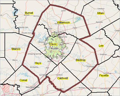 - view developed using ProximityOne CV XE GIS and related GIS project. Urban Areas .. goto top The following graphic shows urban areas (orange fill pattern). Austin city shown with cross-hatch pattern. Select a different city; add a selected group of cities. 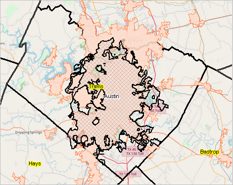 - view developed using ProximityOne CV XE GIS and related GIS project. Public Use Microdata Data Areas (PUMS) .. goto top Learn or extend your abilities to create your own custom demographic-economic estimates for PUMAs. PUMAs are groups of contiguous census tracts having a minimum 100,000 population. Create thematic pattern maps for PUMA area as shown in the graphic below. In the course, learn to develop custom subject matter estimates based on the ACS Public Use Microdata Sample (PUMS). 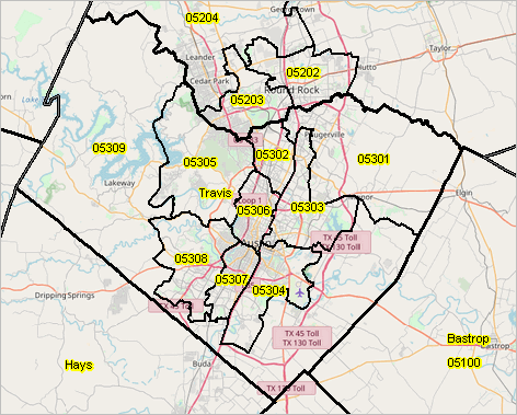 - view developed using ProximityOne CV XE GIS and related GIS project. Patterns of Economic Prosperity by Neighborhood in Travis County, TX Area .. goto top Graphic below shows Travis County area patterns of median household income by census tract. See about detailed tract demographic-economic characteristics) 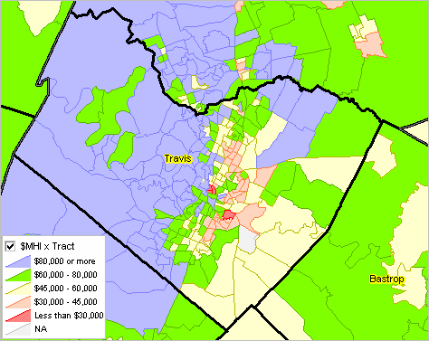 - view developed using ProximityOne CV XE GIS and related GIS project. Patterns of Economic Prosperity by Neighborhood in Travis County, TX Area .. goto top Graphic below shows Travis County area patterns of median household income by block group (BG). Using BG geodemographics can often reveal patterns masked by using larger geography such as tracts. Nested within census tracts, block groups is the smallest geographic area for which national scope demographic-economic data are available.  - view developed using ProximityOne CV XE GIS and related GIS project. Integrating Block Group, Roads, $MHI .. goto top Graphic below shows a zoom-in to a block group to the west of Austin city. The block group (BG) is labeled with median household income. The roads layer is also shown. Click graphic for larger view. In the larger view the identify tool is used to display an attribute profile for one street/road segment (see pointer). Expand window to full screen for best quality view. 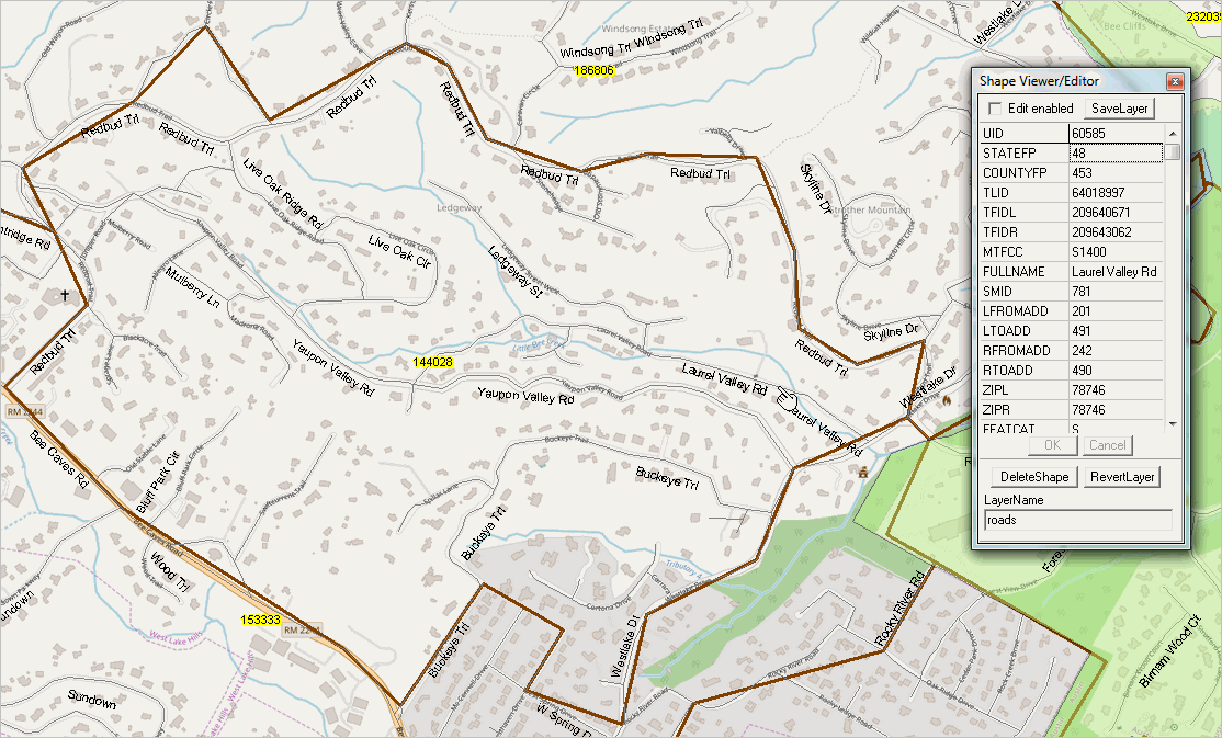 - view developed using ProximityOne CV XE GIS and related GIS project. ZIP Code Areas Integrated with Block Group x $MHI, Roads .. goto top The graphic below shows a zoom-in to a ZIP code area (78746) in west Austin area; ZIP code areas shown with bold black boundary. Patterns of economic properity (median household income) are shown by block group (BG). The roads layer is also shown. Pointer is positioned at block group used in the previous view. See related ZIP Code Demographic-Economic Profile. 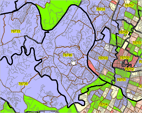 - view developed using ProximityOne CV XE GIS and related GIS project. Austin Area School Districts .. goto top Graphic below shows Austin area school district. See related Austin ISD school district community profile. 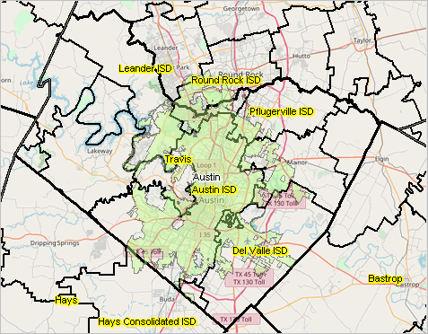 - view developed using ProximityOne CV XE GIS and related GIS project. 116th Congressional Districts in the Travis County, TX Area .. goto top Five 116th Congressional Districts (CDs) intersect Travis County, labeled with CD and shown with different color patterns. Click graphic for larger view. Expand window to full screen for best quality view. 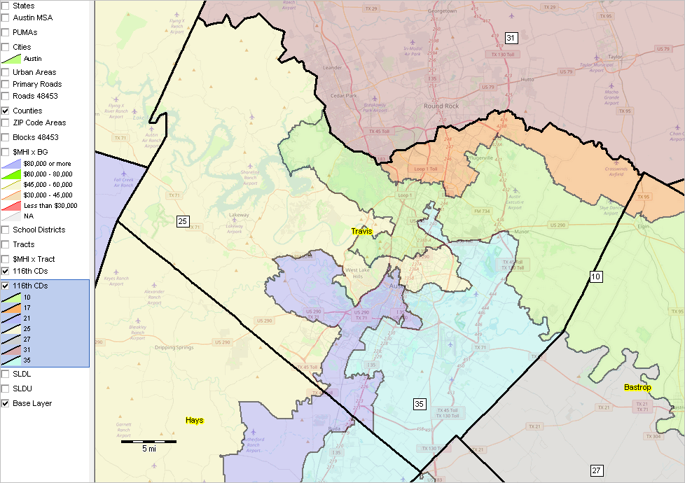 - view developed using ProximityOne CV XE GIS and related GIS project. Travis County, TX Census Blocks .. goto top Graphic below shows Travis County Census 2010 census blocks. Austin city shown with green fill pattern. Click graphic for larger view that illustrates use of the identify tool to display attributes of a census block. Expand window to full screen for best quality view.  - view developed using ProximityOne CV XE GIS and related GIS project. 2018 State Legislative Districts -- Lower .. goto top Graphic below shows Austin area state legislative districts - lower.  - view developed using ProximityOne CV XE GIS and related GIS project. Travis County, TX Election Precincts with %Hispanic by Block Group .. goto top The graphic below shows Travis County, TX Election Precincts layer (black boundaries) layer above %Hispanic by Block Group (based on ACS estimates) layer (see inset legend). Precincts shapefile from Travis County Tax Office. Click graphic for larger view that also shows Interstate highway. Expand window to full screen for best quality view. 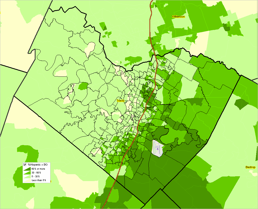 - view developed using ProximityOne CV XE GIS and related GIS project. ProximityOne User Group Join the ProximityOne User Group to keep up-to-date with new developments relating to metros and component geography decision-making information resources. Receive updates and access to tools and resources available only to members. Use this form to join the User Group. Support Using these Resources Learn more about accessing and using demographic-economic data and related analytical tools. Join us in a Data Analytics Lab session. There is no fee for these one-hour Web sessions. Each informal session is focused on a specific topic. The open structure also provides for Q&A and discussion of application issues of interest to participants. Additional Information ProximityOne develops geodemographic-economic data and analytical tools and helps organizations knit together and use diverse data in a decision-making and analytical framework. We develop custom demographic/economic estimates and projections, develop geographic and geocoded address files, and assist with impact and geospatial analyses. Wide-ranging organizations use our tools (software, data, methodologies) to analyze their own data integrated with other data. Follow ProximityOne on Twitter at www.twitter.com/proximityone. Contact us (888-364-7656) with questions about data covered in this section or to discuss custom estimates, projections or analyses for your areas of interest. |
|
|