
|
|
|
Of the nation's 325.7 million people, an estimated 205.0 million (62.9%) live within an incorporated place as of July 1, 2017. Of approximately 19,500 incorporated places, about 76 percent had fewer than 5,000 people and nearly 50 percent had fewer than 1,000 people. Examine characteristics of individual city population trends and compare cities in states, regions and peer groups using the interactive table below. See three related static tables below showing characteristics the 15 largest cities. Use the U.S. by cities shapefile with your GIS projects. See details below. May 2019. This section has been updated with 2018 estimates. .. see http://proximityone.com/places2018.htm. Cities by %Change 2010-2017 -- 10,000 Population or More The following view shows cities with 2017 population of 874,000 or more in blue. Labels show rank among all cities based on 2017 population. These 15 cities have a total 2017 population of 30.6 million of the 205 million total population in all U.S. cities (15%). Click graphic for larger view; expand window to full screen. ... click links in Table 3 below to view maps of these cities. 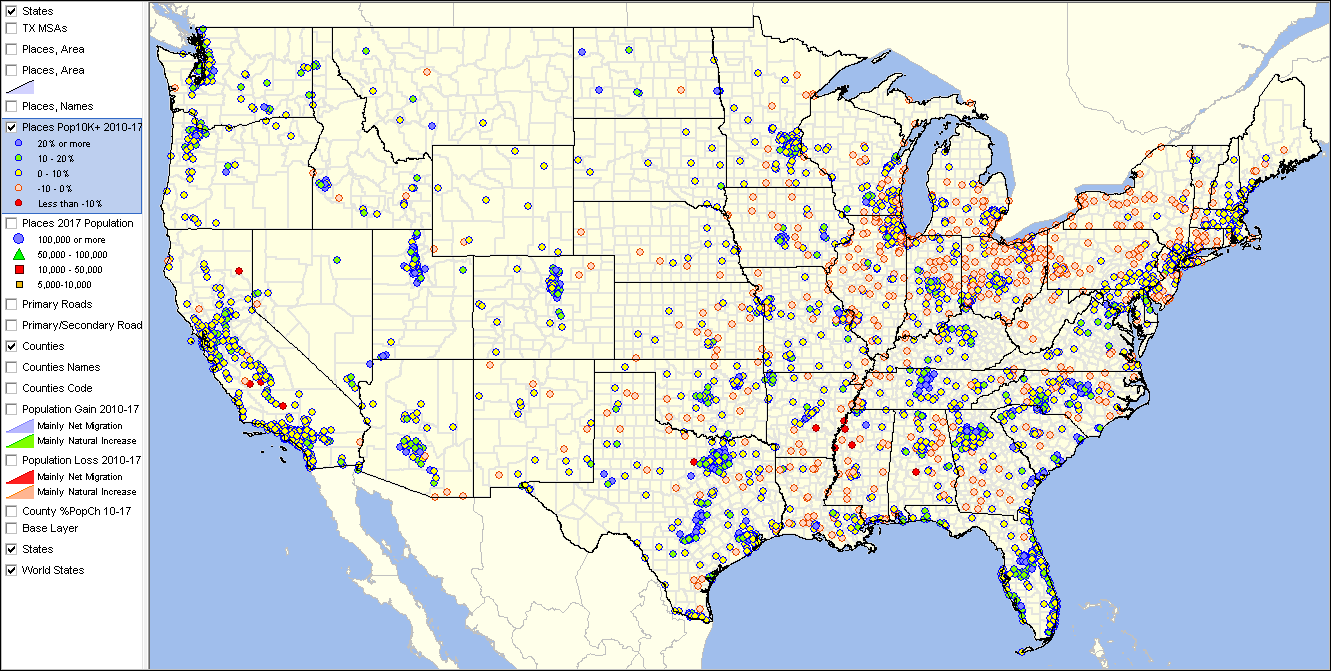 - View developed using the CV XE GIS software. Mapping America's 15 Largest Cities The following view shows cities with 2017 population of 874,000 or more in blue. Labels show rank among all cities based on 2017 population. These 15 cities have a total 2017 population of 30.6 million of the 205 million total population in all U.S. cities (15%). Click graphic for larger view; expand window to full screen. ... click links in Table 3 below to view maps of these cities.  - View developed using the CV XE GIS software. Patterns of City Percent Change in Population 2010-17 -- Cities in the Los Angeles Area The following view shows thematic patterns of population percent change, 2010-17 for cities in the Los Angeles, CA area. See color/interval assignment in legend. Click graphic for larger view; expand window to full screen. Larger view shows city names and 2017 population. 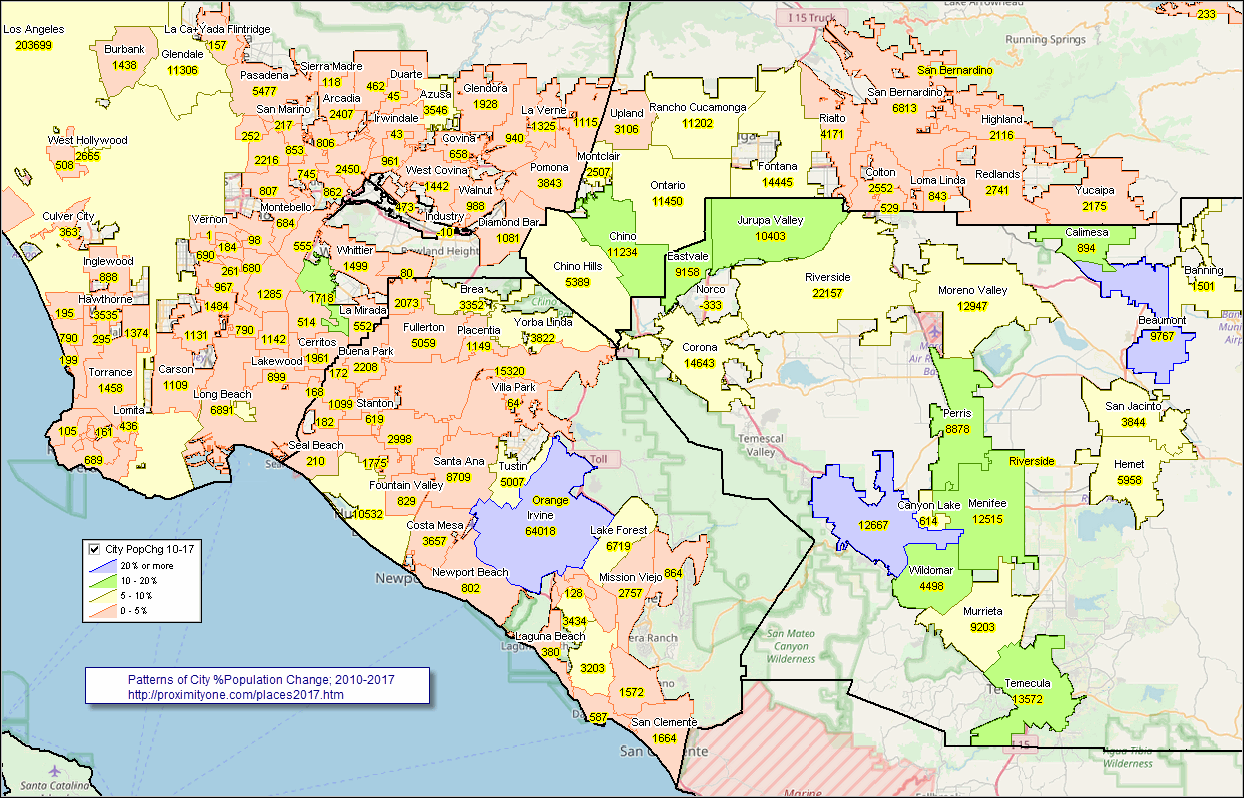 - View developed using the CV XE GIS software. - Flexibly create your own views using the cities GIS project. - Examine city population trends, patterns; zoom to desired areas; label as needed; integrate other data. City/Place Demographics in Context & Related Data • State & Regional Demographic-Economic Characteristics & Patterns .. individual state sections with analytical tools & data access to block level • Metropolitan Area Situation & Outlook .. continuously updated characteristics, patterns & trends for each/all metros • ACS 2016 5-year estimates .. related City/Place Demographic-Economic Interactive Tables .. General Demographics ... Social ... Economic ... Housing Characteristics • Corresponding U.S. by County 2010-2017 Estimates Using the Interactive Table Use the interactive table below view, rank, query and compare cities of interest. View the list of cities with the largest 2017 population by dbl-clicking the header cell "Population 7/1/2017" in the table. Place a state query on the table to select cities in a state of interest and click the header cell "Population 7/1/2017" to view cities in that state ranked by size. Choose other columns to view other relationships. City/Place Population Estimates & Trends Interactive Table: 2010-2017 See usage notes below ranking table. See related interactive tables. Rank on any column by clicking column header; use mouse-over on column header to view description of item. Use horizontal bar, slide right, to view 2017 population, 2010-17 change and percent change. .. use buttons below table for selective columns view. Usage Notes • Click ShowAll between queries/filters. • Use left-most column to select by state. • Find in Name button; click ShowAll button first .. click Find in Name button to search column 1 for text in edit box. .. text entered in edit box is case sensitive. .. partial names are okay to use. .. click with default value to view all rows with "Houston" (no quotes) • Find in CBSA button; click ShowAll button first .. click Find in CBSA button to search column 6 for text in edit box. .. text entered in edit box must be the 5-character CBSA code. .. click with default value to view all rows with "26420" (no quotes) ... 26420 is the Houston, TX metro CBSA code .. enter the CBSA code for a metro of interest. • Find in County button; click ShowAll button first .. click FindCounty button to search column 5 for text in edit box. .. text entered in edit box must be the 5-character state+county FIPS code. .. click with default value to view all rows with "48201" (no quotes) ... 48201 is the Harris County, TX state+county FIPS code .. enter the state+county FIPS code for county of interest. Selected columns buttons • ColSet1 - click to view the set of all years and 2010-17 change columns. • Population Min & Max> button .. click to show only peer group counties based on values in min and max edit boxes. .. enter the minimum 2016 population in the left edit box. .. enter the maximum 2016 population in the right edit box. • Click ShowAll between queries/filters. Static Tables -- 15 largest cities -- goto top Data/characteristics shown in the following static tables may also be viewed in the interactive table above with more flexibility and details. Table 1. 15 Cities With the Largest Numeric Increase Between July 1, 2016, and July 1, 2017 .. populations of 50,000 or more in 2016
Table 2. 15 Fastest-Growing Large Cities and Towns Between July 1, 2016, and July 1, 2017 .. having populations of 50,000 or more in 2016
Table 3. 15 Most Populous Cities as of July 1, 2017 .. goto top These 15 cities have a total 2017 population of 30.6 million of the 205 million total population in all U.S. cities (15%). .. click Name link to view map of city.
Using the U.S. by Cities Shapefile with Integrated Demographics .. goto top The U.S. by city/place shapefile is developed/updated annually as part of the Census Bureau TIGER/Line digital map database. It is the most authoritative and up-to-date source of annually updated incorporated city boundaries. ProximityOne integrates the city population annual time series estimates into the smoothed version of the national U.S. by place shapefile. Users of the CV XE GIS Level 2 or Level 3 software with an active support license may download the U.S. by place shapefile at no fee. The U.S. by place shapefile with integrated estimates may be used with any software that can process shapefiles. About These Data -- goto top City and sub-county population estimates are developed annually by the Census Bureau. The model-based estimates are normally released in May (e.g., 7/1/17 estimates released in May 2018). Population estimates for incorporated places the city with boundaries as defined as of January 1, 2017. Incorporated Cities/Places The legal designations, powers, and functions of incorporated places vary from state to state. Incorporated places include cities, towns (except in New England, New York, and Wisconsin where towns are county administrative subdivision), boroughs (except in Alaska where boroughs are treated as equivalents of counties and New York where five boroughs comprise New York City) and villages. Incorporated places can cross both county boundaries. ProximityOne assigns each city to a county and CMSA/metro (if located in a CBSA). The county is assigned using a U.S. by city point shapefile. The county is assigned to a city for the county that contains the city point (internal area latitude-longitude). The CBSA code is assigned based on the county code (all CBSAs are comprised of one of more counties). Data in Excel/Database Structure Data shown in the table are available in the form of Excel, CSV or DBF structure. Users of the shapefile (described above may use the dbf part of the shapefile for tabular/spread-type analysis and to integrate with other data. Support Using these Resources .. goto top Learn more about demographic economic data and related analytical tools. Join us in a Data Analytics Lab session. There is no fee for these Web sessions. Each informal session is focused on a specific topic. The open structure also provides for Q&A and discussion of application issues of interest to participants. ProximityOne User Group .. goto top Join the ProximityOne User Group to keep up-to-date with new developments relating to geographic-demographic-economic decision-making information resources. Receive updates and access to tools and resources available only to members. Use this form to join the User Group. Additional Information .. goto top ProximityOne develops geographic-demographic-economic data and analytical tools and helps organizations knit together and use diverse data in a decision-making and analytical framework. We develop custom demographic/economic estimates and projections, develop geographic and geocoded address files, and assist with impact and geospatial analyses. Wide-ranging organizations use our software, data and methodologies to analyze their own data integrated with other data. Follow ProximityOne on Twitter at www.twitter.com/proximityone. Contact ProximityOne (888-364-7656) with questions about data covered in this section or to discuss custom estimates, projections or analyses for your areas of interest. |
|
|