
|
|
|
ProximityOne Home Page ZIP Code Data Resources ZIP Code GIS/Mapping Pattern Analysis ZIP Code Equivalence Files interactive applications - ZIP-School District - ZIP-City/Place - ZIP-Census Tract - ZIP-Cong District - ZIP-County - ZIP-Metro Related Sections - Situation & Outlook - Applications Gallery - States - Congressional District - School Districts - Counties - Cities/Places - Tracts/Neighborhoods - Block Groups - Census Blocks - Urban Areas Demographic-Economic Estimates-Projections GIS Thematic Mapping Visual Analysis Tools Ranking Tables National Scope Demographic Change 2000-2010 - States - Metros - Congressional District - School Districts - Counties - Cities/Places - Census Tracts |
ZIP Code to County & Metro Equivalence Table
Use ZIP Code/Census Tract demographic-economic profiles with integrated map showing patterns of neighborhood economic prosperity. See see example for ZIP code 85258. The ZIP code equivalence table meets many needs. Your needs may be similar but different. One alternative is the ProximityOne address-to-county/metro coding service. We can process your address file, assigning codes, county name and metro name to each address record, and return your original address records/file with those attributes appended. Read more below in this section. ZIP Code Geographic-Demographic-Economic Updates scroll section
General updates
10.20.15. Mapping ZIP Code Demographics • tools and data resources for analyzing ZIP Code area patterns • interactive table & GIS applications • see http://proximityone.com/mapping_zipcode_demographics.htm 06.10.15. ZIP Code Demographic-Economic Profiles • structured profiles/datasets for each/all ZIP code areas; examples: • integrated neighborhood patterns of economic prosperity maps; examples: - 33426 Boynton Beach, FL ... 60565 Naperville, IL ... 77019 Houston, TX • get your ZIP code area profile; request ZIP code profile in text section • compare with other geography -- http://proximityone.com/outlook2020dep.htm 02.10.15. Guide to ZIP Code Area Geographic-Demographic-Economic Data Resources • multi-sourced ZIP code geographic-demographic-economic data and access/analysis tools • http://proximityone.com/zipdata_resources.htm 10.10.14. ZIP Code Urban/Rural Patterns • total, urban, rural population & housing; geographic area; population density • interactive table: http://proximityone.com/zip_urban_rural.htm 09.15.14. View ZIP Code Areas in Context of Google Maps API • example: Washington, DC by ZIP Code • example: Kansas City, MO-KS Area by ZIP Code • use Shp2XML to create your own 01.15.14. ZIP Code Richer Demographic-Economic Data (ACS 2012) • View/rank/query/compare ZIP Codes using interactive ranking tables:
08.19.13. ZIP Code Business Characteristics • 2001 and 2011 business establishments by ZIP Code. • Interactive analysis table: establishments, employment, payroll. • Based on employer reported data. • Examine in context with demographics. -- see more http://proximityone.com/zipbusiness.htm 08.14.13. Mapping ZIP Code Areas of Interest • Create custom maps showing ZIP Code areas in context with OpenStreetMap and roads/streets. • View ZIP Code areas in context of counties and metros. • Optionally add political areas (e.g., cities, counties, congressional districts, other) to map view. • Optionally add statistical areas (e.g. census tracts, census blocks, metros, other) to map view. • Optionally integrate demographic-economic data for thematic mapping and pattern analysis. • Start using the CV XE GeoGateway feature: -- about GeoGateway ... run CV XE installer 02.13.13. Block Group-ZIP Code Equivalence Table; Work Force Analysis • Use interactive table to examine what block groups intersect with ZIP codes of interest. • Examine labor force characteristics by block group and ZIP code area. • See http://proximityone.com/blockgroups.htm. 12.07.12. ZIP Code Richer Demographic-Economic Data (ACS 2011 ) • View/rank/query/compare ZIP Codes using interactive ranking tables:
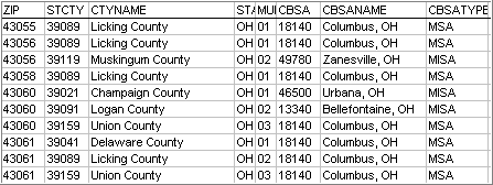
Using the Interactive ZIP Code Equivalence/Look-up Table The interactive equivalence/look-up table below shows all U.S. 5-digit ZIP codes sorted first by state-county (FIPS) code and then by ZIP code (within county). View ZIP codes in one state using the State selection button. To locate a ZIP code of interest, either use the Find ZIP query or sort on the ZIP code column and then scroll down the table until the ZIP of interest is located. Each row/line shows the ZIP code, state-county code, county name, core-based statistical area (CBSA) code and name, CBSA type (MSA or MISA) and metropolitan division (MD) code and name. Only some MSAs, meeting certain conditions, have component MDs. For ZIPs with no CBSA, the ZIP code is not located in a metropolitan area. The Find ZIP start value uses ZIP 43060 to illustrate a ZIP code located in multiple counties and multiple metros. See details The Multi column shows the sequence number of the county in which the ZIP is located (00 if one county). Illustrating Intersection of ZIP Code Area 85258 with Census Tracts 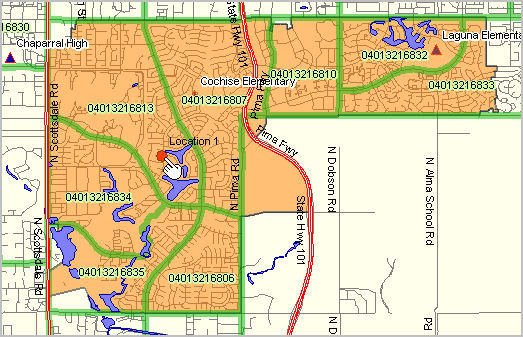
Demographic-Economic Profiles for ZIP Code 85258 and Tract 04013216813 • ZIP Code Area 85258 -- Scottsdale, AZ area • Census Tract 04013216813 -- Scottsdale, AZ area • Get profiles for any area: census tract, ZIP code area, city, place, school district. ZIP Code - County - Metro Equivalence Interactive Table Click column header to sort; click again to sort other direction. See related Ranking Tables Main Page Multi-County, Multi-Metro ZIP Code Areas Multi-area county and metro ZIP codes ... 30,422 ZIP codes existed as ZIP codes totally within one county (includes ZIP code areas, post office delivery locations, other fixed address delivery locations). In addition, 10,839 ZIP codes were located in two or more counties, making for a total of 41,241 unique 5-digit ZIP codes. There are many instances where ZIP code areas cross county boundaries. The equivalence table includes 55,685 ZIP codes, reflecting the occurrence of the ZIP code for each county/metro in which it was located. The following map shows ZIP code 43060 (yellow fill color) that is partly contained in three counties (names as blue labels). This view also shows that a ZIP code can be in multiple metros; each of these three counties are in different metros (names as yellow labels). The second graphic shows these ZIP codes in a tabular view. 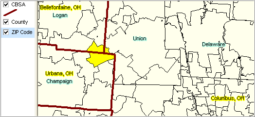
Extended Data and Other Lookups/Equivalencing The same data shown in this table are also available for 7- and 9-digit ZIP codes. These data are not included in the ranking table for reasons of size and typical usage. The 2.8 million record dataset can be processed with a special look-up and code assignment program. Register using this form for information on more detailed data and related software (note special interest ZIP code equivalencing in text section). ZIP Code Equivalence Files The following 2010 ZIP Code (ZCTA) equivalence/relationship files are available. Contact us for details (888-364-7656). • ZIP to County • ZIP to County Subdivision • ZIP to Place • ZIP to Census Tract • ZIP to Congressional District • ZIP to Metropolitan and Micropolitan Statistical Areas Address-to-County/Metro Coding Service Use the ProximityOne address-to-county/metro coding service to have county, metro and more assigned to your address records. We process your address file, assigning codes, county name and metro name to each address record, and return your original address records/file with those attributes appended. Coding the address to census block, rather than using ZIP code to county only, provides a much more accurate method of assigning/associating your addresses to a county/metro or other area. No learning curve, fast turnaround. Contact us for more information (888-364-7656). Sample input file (scroll section) Provide your address file in CSV or XLS structured like shown below.
id,Address,City,State,zip
Store 0003,2888 Brice Road,Columbus,OH,43232 Store 0004,2700 Rainier Avenue South,Seattle,WA,98144 Store 0005,4817 North Kickapoo Street,Shawnee,OK,74804 Store 0008,201 Conley Road North,Columbia,MO,65201 Store 0009,2168 Us 68 South,Bellefontaine,OH,43311 Store 0010,101 Andover Park East,Tukwila,WA,98188 Store 0012,100 North Creasy Lane,Lafayette,IN,47905 Store 0015,1055 W Antelope Drive,Layton,UT,84041 Store 0016,550 Island Ford Road,Madisonville,KY,42431 Store 0018,901 Appleway Avenue,Coeur D Alene,ID,83814 Store 0019,1952 North State,Fremont,OH,43420 Store 0021,270 Dairy Road,Kahului,HI,96732 Store 0022,1755 Quentin Road,Lebanon,PA,17042 Store 0026,2701 South Orchard Street,Tacoma,WA,98466 Store 0028,3620 Emmett F Lowry Expway,Texas City,TX,77590 Store 0031,1415 7Th Avenue E,Hendersonville,NC,28792 Store 0033,955 Bullsboro Drive,Newnan,GA,30265 Store 0035,1717 Freeway Drive,Mount Vernon,WA,98273 Store 0037,3600 Park Mill Run Drive,Hilliard,OH,43026 Store 0040,11959 Northupway,Bellevue,WA,98005 Store 0042,5252 Salem Avenue,Trotwood,OH,45426 Store 0044,4115 Mall Drive,Steubenville,OH,43952 Store 0046,1300 Mall Drive,Benton Harbor,MI,49022 Store 0049,13225 Beach Blvd,Westminster,CA,92683 Store 0052,3636 North Vermillion,Danville,IL,61832 Store 0053,4430 Illinois Road,Fort Wayne,IN,46804 Store 0056,14873 Carmenita Road,Norwalk,CA,90650 Store 0057,3435 Agency,Burlington,IA,52601 Store 0059,2050 Sycamore Road,Dekalb,IL,60115 Store 0061,3300 169Th Place Ne,Arlington,WA,98223 Store 0063,3315 North Loop 250 W,Midland,TX,79707 Store 0066,111 Davidson Avenue,Mount Vernon,IL,62864 Store 0069,"6122 ""B"" Drive North",Battle Creek,MI,49014 Store 0071,2219 Rieth Boulevard,Goshen,IN,46526 Store 0072,3500 North 14Th Street,Ponca City,OK,74601 Store 0075,3301 Kell Blvd,Wichita Falls,TX,76308 Store 0077,5500 Milan Road ,Sandusky,OH,44870 Store 0080,1904 North Prospect Avenue,Champaign,IL,61822 Store 0082,3501 South Medford,Lufkin,TX,75901 Store 0086,3565 Holland Road,Virginia Beach,VA,23452 Store 0088,1369 Division Street,Adrian,MI,49221 Store 0089,2850-I Centre Drive,Fairborn,OH,45324 Store 0090,5301 Sherwood Way,San Angelo,TX,76904 Store 0091,1800 South Parkway,Corinth,MS,38834 Store 0092,531 West Carl Sandburg Drive,Galesburg,IL,61401 Store 0095,4120 Dowlen Road,Beaumont,TX,77706 Store 0097,5002 Garth Road,Baytown,TX,77521 Store 0098,19935 Katy Freeway,Houston,TX,77094 Store 0102,1701 South Havana Street,Aurora,CO,80012 Store 0103,3225 Freedom Blvd,Bryan,TX,77802 Coded Output File (scroll section) The output file was generated by processing the above input file is shown as a graphic below. Note that it includes the original columns plus census block code, median household income for the block group where address is located, county code and name, metro (CBSA) code, type and name. The median household income is based on the latest estimate available from the American Community Survey. Alternative or additional demographic items may be added. 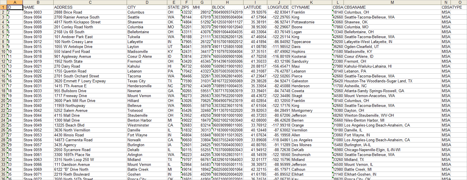
Shapefile & Map A shapefile is created as the addresses are coded. The graphic below shows the address locations as red markers. See your address coded data shown in a map view. Optionally use this shapefile in GIS applications. The larger view (click graphic) shows metro boundaries. 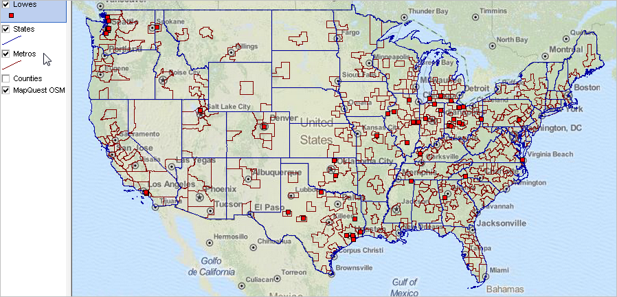 Click graphic for larger view and details. Demographic-Economic Profile Geocodes To order a demographic-economic profile (see above) for cities, counties or school districts, get codes to use in order form from lists provided here: • City -- 7 character state-city code - example: the code for Houston, TX is 0100124 • County -- 5 character state-county code - example: the code for Harris County, TX is 48201 • School District - 7 character state-school district code - example: the code for Harris ISD, TX is 4823640 ProximityOne User Group Join the ProximityOne User Group to keep up-to-date with new developments relating to metros and component geography decision-making information resources. Receive updates and access to tools and resources available only to members. Use this form to join the User Group. Support Using these Resources Learn more about small area demographic-economic characteristics, ZIP code geographic drill-down and related analytical tools. Join us in a Decision-Making Information Web session. There is no fee for these one-hour Web sessions. Each informal session is focused on a specific topic. The open structure also provides for Q&A and discussion of application issues of interest to participants. Additional Information ProximityOne develops geographic-demographic-economic data and analytical tools and helps organizations knit together and use diverse data in a decision-making and analytical framework. We develop custom demographic/economic estimates and projections, develop geographic and geocoded address files, and assist with impact and geospatial analyses. Wide-ranging organizations use our tools (software, data, methodologies) to analyze their own data integrated with other data. Follow ProximityOne on Twitter at www.twitter.com/proximityone. Contact ProximityOne (888-364-7656) with questions about data covered in this section or to discuss custom estimates, projections or analyses for your areas of interest. | ||||||||||||
|
|