
|
|
|
-- integrated with American Community Survey 2020 -- data access & use resources -- Census 2020 is here; optimize its use in meeting your goals April 2021. The first 2020 decennial census geography data were released January 2021. The TIGER 2020 Digital Map Database includes shapefiles developed for use with Geographic Information System (GIS) software. Demographic Data Access The initial Census 2020 demographic data to be released will be the re-apportionment state population totals by April 30, 2021, for use in the apportionment of the U.S. House of Representatives. More detailed data, to the census block level will be released starting in mid-August 2021. The Census 2020 data are closely integrated with the American Community Survey (ACS) and Census model-based estimates program data. Selected dates associated with release/availability of key data resources are summarized below. The ACS 2020 data will be closely associated with the Census 2020 data. This section is focused on Census 2020 oriented toward data access and use applications in Hawaii developed by Warren Glimpse/ProximityOne. While Hawaii geography is used, the applications and scope of geography/demographics reviewed are similar and applicable to any state. ProximityOne has no affiliation with the Census Bureau. This section is sponsored by ProximityOne alone. This section is updated from time-to-time as Census 2020 related developments occur. Comparing 2010 & 2020 Census Blocks The following graphic provides a visual comparison of Census 2010 census blocks (red boundary) with Census 2020 census blocks (gray, bold boundary) in the vicinity of Mililani place (bold brown boundary) in Honolulu County, HI. Click graphic for larger view; expand browser to full window for best quality view. 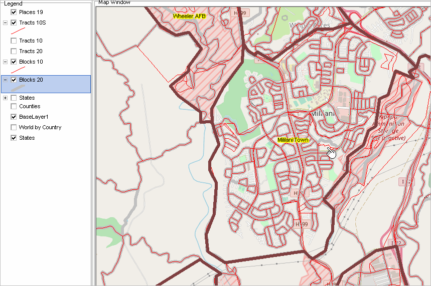
Comparing 2010 & 2020 Block Groups forthcoming ... Comparing 2010 & 2020 Census Tracts The following graphic provides a visual comparison of Census 2010 census tracts (red boundary) with Census 2020 census tract (gray, bold boundary) in the vicinity of Mililani place (bold brown boundary) in Honolulu County, HI. Click graphic for larger view; expand browser to full window for best quality view. 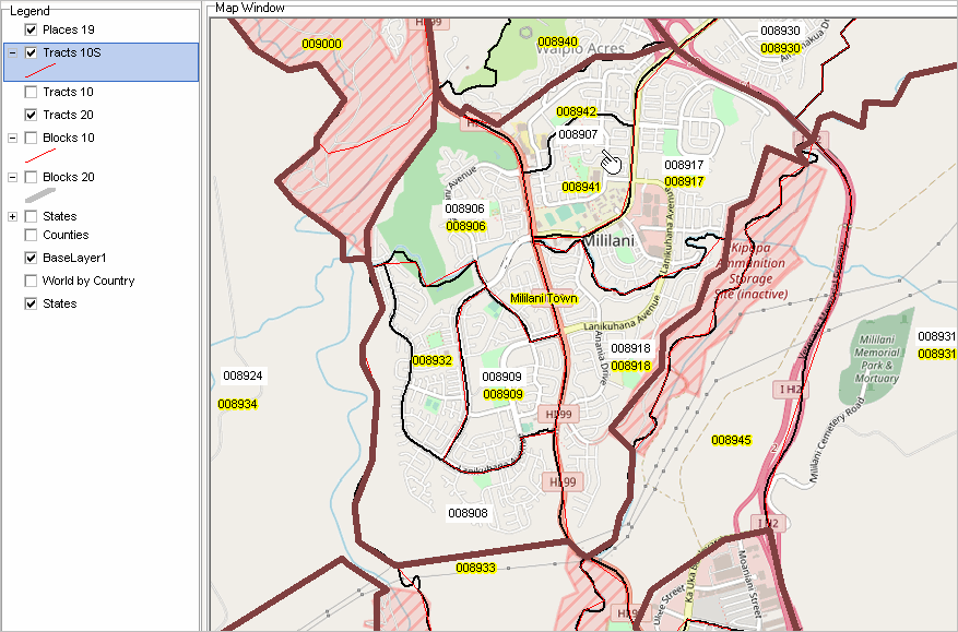
Adding & Using TIGER 2020 Intersection-to-Intersection Roads forthcoming ... Accessing & Using the Census 2020 P.L. 94-171 Data This subsection will provide step-by-step details on theese topics using Hawaii geography as a procedural template: • What the P.L. 94-171 redistricting files contain (geography and demographics) • Benefits from using the P.L. 94-171 data • Relationship of P.L. 94-171 data to other Census 2020 data reosurces • Accessing and adding selected P.L. 94-171 shapefiles to a GIS projecton a Windows computer. • Accessing P.L. 94-171 subject matter datasets and converting for use on a Windows computer. .. includes review of file content and structure. • Integrating the P.L. 94-171 demographic data with corresponding shapefile for mapping & geospatial analysis. • Adding the shapefile/data to a GIS Project & examining selected applcations. • Comparing Census 2010 and Census 2020 geodemographics using the GIS Project ProximityOne User Group Join the ProximityOne User Group to keep up-to-date with new developments relating to metros and component geography decision-making information resources. Receive updates and access to tools and resources available only to members. Use this form to join the User Group. Support Using these Resources Learn more about accessing and using demographic-economic data and related analytical tools. Join us in a Data Analytics Lab session. There is no fee for these one-hour Web sessions. Each informal session is focused on a specific topic. The open structure also provides for Q&A and discussion of application issues of interest to participants. Additional Information ProximityOne develops geodemographic-economic data and analytical tools and helps organizations knit together and use diverse data in a decision-making and analytical framework. We develop custom demographic/economic estimates and projections, develop geographic and geocoded address files, and assist with impact and geospatial analyses. Wide-ranging organizations use our tools (software, data, methodologies) to analyze their own data integrated with other data. Follow ProximityOne on Twitter at www.twitter.com/proximityone. Contact us (888-364-7656) with questions about data covered in this section or to discuss custom estimates, projections or analyses for your areas of interest. |
|
|