|
|
Decision-Making Information

|
ProximityOne
information resources & solutions
(888) DMI-SOLN
(888) 364-7656
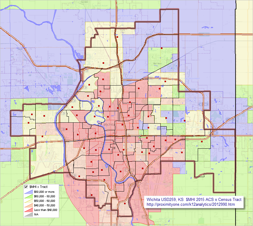
Schools in context of
neighborhood economic prosperity
click graphic for larger view
|
Wichita USD, KS K12Analytics
... School District GeoDemographic Information System
... data analytics tools for K-12 schools & school districts
This section provides information about the structure and use of the Wichita USD, Kansas (USD259) K12Analytics tools and data.
The USD259 K12Analytics uses the
School District GeoDemographic Information System
(SDGIS) integrated software and database package.
Using GIS technologies,
SDGIS is developed for use by schools, school districts, education agencies and stakeholder organizations.
ProximityOne develops, deploys and supports SDGIS tailored to the individual school/education agency structure and needs.
Individual SDGIS packages are structured around a set of data that are unique in geographic scope and typically
focused on one or a set of school districts.
Contents
• SDGIS Start-up View
• SDGIS GIS Project -- Structure & Layers
• K-12 Schools Interactive Table
• SDGIS Installation
.. SDGIS Voter Precincts Installation -- add-on
• Custom Settings
• Optional Add-on Features
• Related Resources
• Things to Know & FAQ
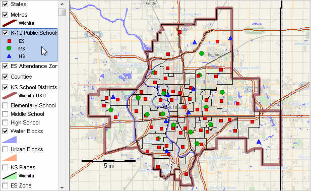
Wichita USD259, KS SDGIS Start-up View
- Wichita USD259 shown with bold brown boundary, located in Sedgwick County and
Wichita, KS MSA
- elementary schools: red markers; elementary attendance zones: black boundaries.
- Wichita USD, KS demographic-economic profile
... see profiles for other districts
- Wichita city, KS demographic-economic profile
... see profiles for other cities
-- view created using CVGIS and associated GIS Project
Additional Views - click link to view
•
Wichita USD259 in context of Wichita metro and component counties
•
Schools in context of neighborhood economic prosperity
•
Seltzer ES in context of Attendance Zone
U.S. National Scope K-12 Public Schools, 2014-15 -- Interactive Table
Click ShowAll button between Find/Queries; click LEAID button below table to view only schools for USD259.
Use mouseover on column header to view column description.
See usage notes below table.
See related interactive tables.
Usage Notes
Click Show All/Refresh button between queries.
Click Show All/Refresh button ... then click LEAID button below table to select only Wichita USD schools (89)
.. use any Federal school district geocode (7 characters) to view schools for that district (all U.S.).
Click Show All/Refresh button ... then click City button below table to select only Wichita city schools (139)
.. use any city Federal geocode (7 characters) to view schools for that city (all U.S.).
Click Show All/Refresh button ... then click StCty button below table to select only Sedgwick county schools (157)
.. use any State+County FIPS geocode (5 characters) to view schools for that county (all U.S.).
Click Show All/Refresh button ... then click ZIP button below table to select only schools in ZIP 67210 (3)
.. enter any ZIP code (5 characters) to view schools for that ZIP code (all U.S.).
See more information about these data and using the tools in the K-12 schools main section.
.. that page provides more details about codes, subject matter items and usage.
SDGIS GIS Project .. goto top
The SDGIS GIS project file is a text file that contains a list of layers that may be viewed when the
GIS project file is opened using the CV XE GIS software.
Layers included is the Wichita USD, Kansas SDGIS are described below. Using the CV XE GIS software, layers may be removed, added or attributes modified.
| Layer# | Name | Shapefile/Resource |
| 1 | States1 | cb_2016_us_state_500k.shp |
| 2 | Primary Roads US | tl_2016_us_primaryroads.shp |
| 3 | CBSAs U.S. | cb_2016_us_cbsa_500k.shp |
| 4 | Counties U.S. | cb_2016_us_county_500k_pop2016.shp |
| 5 | Cities/places statewide | cb_2016_48_place_500k.shp |
| 6 | School districts state1 | sd1516_ussd1015_48.shp |
| 7 | Schools state1 | sch1415_2017pts_48.shp |
| 8 | Schools state2 | sch1415_2017pts_48.shp |
| 9 | Schools state3 | sch1415_2017pts_48.shp |
| 10 | SAZ2 | saz_WUSD.shp |
| 11 | SAZ1 | saz_WUSD.shp |
| 12 | SAZ | saz_WUSD.shp |
| 13 | Sedgwick roads | tl_2016_48029_edges.shp |
| 14 | Sedgwick blocks | tabblock2010_48_pophu_029.shp |
| 15 | block groups statewide | cb_2016_48_bg_500k.shp |
| 16 | tracts statewide2 | cb_2016_48_tract_500k_acs15itemset1.shp |
| 17 | tracts statewide1 | cb_2016_48_tract_500k_acs15itemset1.shp |
| 18 | States2 | cb_2015_us_state_500k.shp |
| 19 | World countries | world_countries.shp |
Layer File Layout/Fields -- scroll section within master scroll section
Layer 1 -- LayerName: States1 -- LayerFileName: cb_2016_us_state_500k.shp
| 1-1 | STATEFP | C, 2, 0 |
| 1-2 | STATENS | C, 8, 0 |
| 1-3 | AFFGEOID | C, 11, 0 |
| 1-4 | GEOID | C, 2, 0 |
| 1-5 | STUSPS | C, 2, 0 |
| 1-6 | NAME | C, 100, 0 |
| 1-7 | LSAD | C, 2, 0 |
| 1-8 | ALAND | N, 14, 0 |
| 1-9 | AWATER | N, 14, 0 |
Layer 2 -- LayerName: Primary Roads US -- LayerFileName: tl_2016_us_primaryroads.shp
| 2-1 | LINEARID | C, 22, 0 |
| 2-2 | FULLNAME | C, 100, 0 |
| 2-3 | RTTYP | C, 1, 0 |
| 2-4 | MTFCC | C, 5, 0 |
Layer 3 -- LayerName: CBSAs U.S. -- LayerFileName: cb_2016_us_cbsa_500k.shp
| 3-1 | CBSA | C, 5, 0 |
| 3-2 | NAMELSAD | C, 100, 0 |
| 3-3 | NAME | C, 100, 0 |
| 3-4 | LSAD | C, 4, 0 |
| 3-5 | TYPE | C, 4, 0 |
| 3-6 | CSAFP | C, 3, 0 |
| 3-7 | CBSAFP | C, 5, 0 |
| 3-8 | GEOID | C, 5, 0 |
| 3-9 | ALAND | N, 14, 0 |
| 3-10 | AWATER | N, 14, 0 |
| 3-11 | CEN2010 | N, 9, 0 |
| 3-12 | BASE2010 | N, 9, 0 |
| 3-13 | POP2010 | N, 9, 0 |
| 3-14 | POP2011 | N, 9, 0 |
| 3-15 | POP2012 | N, 9, 0 |
| 3-16 | POP2013 | N, 9, 0 |
| 3-17 | POP2014 | N, 9, 0 |
| 3-18 | POP2015 | N, 9, 0 |
| 3-19 | POP2016 | N, 9, 0 |
| 3-20 | CHG1016 | N, 9, 0 |
| 3-21 | CHG1016P | N, 9, 1 |
| 3-22 | RANK2016 | N, 9, 0 |
| 3-23 | RANK1016 | N, 9, 0 |
| 3-24 | RANK1016P | N, 9, 0 |
| 3-25 | NCHG2010 | N, 9, 0 |
| 3-26 | NCHG2011 | N, 9, 0 |
| 3-27 | NCHG2012 | N, 9, 0 |
| 3-28 | NCHG2013 | N, 9, 0 |
| 3-29 | NCHG2014 | N, 9, 0 |
| 3-30 | NCHG2015 | N, 9, 0 |
| 3-31 | NCHG2016 | N, 9, 0 |
| 3-32 | BIRTHS2010 | N, 9, 0 |
| 3-33 | BIRTHS2011 | N, 9, 0 |
| 3-34 | BIRTHS2012 | N, 9, 0 |
| 3-35 | BIRTHS2013 | N, 9, 0 |
| 3-36 | BIRTHS2014 | N, 9, 0 |
| 3-37 | BIRTHS2015 | N, 9, 0 |
| 3-38 | BIRTHS2016 | N, 9, 0 |
| 3-39 | DEATHS2010 | N, 9, 0 |
| 3-40 | DEATHS2011 | N, 9, 0 |
| 3-41 | DEATHS2012 | N, 9, 0 |
| 3-42 | DEATHS2013 | N, 9, 0 |
| 3-43 | DEATHS2014 | N, 9, 0 |
| 3-44 | DEATHS2015 | N, 9, 0 |
| 3-45 | DEATHS2016 | N, 9, 0 |
| 3-46 | NATINC2010 | N, 9, 0 |
| 3-47 | NATINC2011 | N, 9, 0 |
| 3-48 | NATINC2012 | N, 9, 0 |
| 3-49 | NATINC2013 | N, 9, 0 |
| 3-50 | NATINC2014 | N, 9, 0 |
| 3-51 | NATINC2015 | N, 9, 0 |
| 3-52 | NATINC2016 | N, 9, 0 |
| 3-53 | INTMIG2010 | N, 9, 0 |
| 3-54 | INTMIG2011 | N, 9, 0 |
| 3-55 | INTMIG2012 | N, 9, 0 |
| 3-56 | INTMIG2013 | N, 9, 0 |
| 3-57 | INTMIG2014 | N, 9, 0 |
| 3-58 | INTMIG2015 | N, 9, 0 |
| 3-59 | INTMIG2016 | N, 9, 0 |
| 3-60 | DOMMIG2010 | N, 9, 0 |
| 3-61 | DOMMIG2011 | N, 9, 0 |
| 3-62 | DOMMIG2012 | N, 9, 0 |
| 3-63 | DOMMIG2013 | N, 9, 0 |
| 3-64 | DOMMIG2014 | N, 9, 0 |
| 3-65 | DOMMIG2015 | N, 9, 0 |
| 3-66 | DOMMIG2016 | N, 9, 0 |
| 3-67 | NETMIG2010 | N, 9, 0 |
| 3-68 | NETMIG2011 | N, 9, 0 |
| 3-69 | NETMIG2012 | N, 9, 0 |
| 3-70 | NETMIG2013 | N, 9, 0 |
| 3-71 | NETMIG2014 | N, 9, 0 |
| 3-72 | NETMIG2015 | N, 9, 0 |
| 3-73 | NETMIG2016 | N, 9, 0 |
| 3-74 | REDID2010 | N, 9, 0 |
| 3-75 | REDID2011 | N, 9, 0 |
| 3-76 | REDID2012 | N, 9, 0 |
| 3-77 | REDID2013 | N, 9, 0 |
| 3-78 | REDID2014 | N, 9, 0 |
| 3-79 | REDID2015 | N, 9, 0 |
| 3-80 | REDID2016 | N, 9, 0 |
Layer 4 -- LayerName: Counties U.S. -- LayerFileName: cb_2016_us_county_500k_pop2016.shp
| 4-1 | STATEFP | C, 2, 0 |
| 4-2 | COUNTYFP | C, 3, 0 |
| 4-3 | COUNTYNS | C, 8, 0 |
| 4-4 | AFFGEOID | C, 14, 0 |
| 4-5 | GEOID | C, 5, 0 |
| 4-6 | NAME | C, 100, 0 |
| 4-7 | LSAD | C, 2, 0 |
| 4-8 | ALAND | N, 14, 0 |
| 4-9 | AWATER | N, 14, 0 |
| 4-10 | CSAFP | C, 3, 0 |
| 4-11 | CBSAFP | C, 5, 0 |
| 4-12 | METDIVFP | C, 5, 0 |
| 4-13 | INTPTLAT | C, 11, 0 |
| 4-14 | INTPTLON | C, 12, 0 |
| 4-15 | CEN2010 | N, 9, 0 |
| 4-16 | POP2010 | N, 9, 0 |
| 4-17 | POP2011 | N, 9, 0 |
| 4-18 | POP2012 | N, 9, 0 |
| 4-19 | POP2013 | N, 9, 0 |
| 4-20 | POP2014 | N, 9, 0 |
| 4-21 | POP2015 | N, 9, 0 |
| 4-22 | POP2016 | N, 9, 0 |
| 4-23 | CHG1015 | N, 9, 0 |
| 4-24 | CHG1015P | N, 9, 1 |
| 4-25 | CHG1016 | N, 9, 0 |
| 4-26 | CHG1016P | N, 9, 1 |
| 4-27 | NCHG2010 | N, 9, 0 |
| 4-28 | NCHG2011 | N, 9, 0 |
| 4-29 | NCHG2012 | N, 9, 0 |
| 4-30 | NCHG2013 | N, 9, 0 |
| 4-31 | NCHG2014 | N, 9, 0 |
| 4-32 | NCHG2015 | N, 9, 0 |
| 4-33 | NCHG2016 | N, 9, 0 |
| 4-34 | BIRTHS2010 | N, 9, 0 |
| 4-35 | BIRTHS2011 | N, 9, 0 |
| 4-36 | BIRTHS2012 | N, 9, 0 |
| 4-37 | BIRTHS2013 | N, 9, 0 |
| 4-38 | BIRTHS2014 | N, 9, 0 |
| 4-39 | BIRTHS2015 | N, 9, 0 |
| 4-40 | BIRTHS2016 | N, 9, 0 |
| 4-41 | DEATHS2010 | N, 9, 0 |
| 4-42 | DEATHS2011 | N, 9, 0 |
| 4-43 | DEATHS2012 | N, 9, 0 |
| 4-44 | DEATHS2013 | N, 9, 0 |
| 4-45 | DEATHS2014 | N, 9, 0 |
| 4-46 | DEATHS2015 | N, 9, 0 |
| 4-47 | DEATHS2016 | N, 9, 0 |
| 4-48 | NATINC2010 | N, 9, 0 |
| 4-49 | NATINC2011 | N, 9, 0 |
| 4-50 | NATINC2012 | N, 9, 0 |
| 4-51 | NATINC2013 | N, 9, 0 |
| 4-52 | NATINC2014 | N, 9, 0 |
| 4-53 | NATINC2015 | N, 9, 0 |
| 4-54 | NATINC2016 | N, 9, 0 |
| 4-55 | NATINC1016 | N, 9, 0 |
| 4-56 | INTMIG2010 | N, 9, 0 |
| 4-57 | INTMIG2011 | N, 9, 0 |
| 4-58 | INTMIG2012 | N, 9, 0 |
| 4-59 | INTMIG2013 | N, 9, 0 |
| 4-60 | INTMIG2014 | N, 9, 0 |
| 4-61 | INTMIG2015 | N, 9, 0 |
| 4-62 | INTMIG2016 | N, 9, 0 |
| 4-63 | DOMMIG2010 | N, 9, 0 |
| 4-64 | DOMMIG2011 | N, 9, 0 |
| 4-65 | DOMMIG2012 | N, 9, 0 |
| 4-66 | DOMMIG2013 | N, 9, 0 |
| 4-67 | DOMMIG2014 | N, 9, 0 |
| 4-68 | DOMMIG2015 | N, 9, 0 |
| 4-69 | DOMMIG2016 | N, 9, 0 |
| 4-70 | NETMIG2010 | N, 9, 0 |
| 4-71 | NETMIG2011 | N, 9, 0 |
| 4-72 | NETMIG2012 | N, 9, 0 |
| 4-73 | NETMIG2013 | N, 9, 0 |
| 4-74 | NETMIG2014 | N, 9, 0 |
| 4-75 | NETMIG2015 | N, 9, 0 |
| 4-76 | NETMIG2016 | N, 9, 0 |
| 4-77 | NETMIG1016 | N, 9, 0 |
| 4-78 | RES2010 | N, 9, 0 |
| 4-79 | RES2011 | N, 9, 0 |
| 4-80 | RES2012 | N, 9, 0 |
| 4-81 | RES2013 | N, 9, 0 |
| 4-82 | RES2014 | N, 9, 0 |
| 4-83 | RES2015 | N, 9, 0 |
Layer 5 -- LayerName: Cities/places statewide -- LayerFileName: cb_2016_48_place_500k.shp
| 5-1 | STATEFP | C, 2, 0 |
| 5-2 | PLACEFP | C, 5, 0 |
| 5-3 | PLACENS | C, 8, 0 |
| 5-4 | AFFGEOID | C, 16, 0 |
| 5-5 | GEOID | C, 7, 0 |
| 5-6 | NAME | C, 100, 0 |
| 5-7 | LSAD | C, 2, 0 |
| 5-8 | ALAND | N, 14, 0 |
| 5-9 | AWATER | N, 14, 0 |
Layer 6 -- LayerName: School districts state1 -- LayerFileName: sd1516_ussd1015_48.shp
| 6-1 | STATEFP | C, 2, 0 |
| 6-2 | SDLEA | C, 5, 0 |
| 6-3 | GEOID | C, 7, 0 |
| 6-4 | NAME | C, 100, 0 |
| 6-5 | LSAD | C, 2, 0 |
| 6-6 | LOGRADE | C, 2, 0 |
| 6-7 | HIGRADE | C, 2, 0 |
| 6-8 | MTFCC | C, 5, 0 |
| 6-9 | SDTYP | C, 1, 0 |
| 6-10 | FUNCSTAT | C, 1, 0 |
| 6-11 | ALAND | N, 14, 0 |
| 6-12 | AWATER | N, 14, 0 |
| 6-13 | INTPTLAT | C, 11, 0 |
| 6-14 | INTPTLON | C, 12, 0 |
| 6-15 | TPOP_10 | N, 9, 0 |
| 6-16 | TPOP_11 | N, 9, 0 |
| 6-17 | TPOP_12 | N, 9, 0 |
| 6-18 | TPOP_13 | N, 9, 0 |
| 6-19 | TPOP_14 | N, 9, 0 |
| 6-20 | TPOP_15 | N, 9, 0 |
| 6-21 | TPOP | N, 9, 0 |
| 6-22 | PTPOP | N, 9, 1 |
| 6-23 | POP517_10 | N, 9, 0 |
| 6-24 | POP517_11 | N, 9, 0 |
| 6-25 | POP517_12 | N, 9, 0 |
| 6-26 | POP517_13 | N, 9, 0 |
| 6-27 | POP517_14 | N, 9, 0 |
| 6-28 | POP517_15 | N, 9, 0 |
| 6-29 | TPOP5 | N, 9, 0 |
| 6-30 | PPOP5 | N, 9, 1 |
| 6-31 | RCPOV_10 | N, 9, 0 |
| 6-32 | RCPOV_11 | N, 9, 0 |
| 6-33 | RCPOV_12 | N, 9, 0 |
| 6-34 | RCPOV_13 | N, 9, 0 |
| 6-35 | RCPOV_14 | N, 9, 0 |
| 6-36 | RCPOV_15 | N, 9, 0 |
| 6-37 | RCPOP | N, 9, 0 |
| 6-38 | PRCPOP | N, 9, 1 |
| 6-39 | PPOP517 | N, 9, 1 |
| 6-40 | PRCPOV517 | N, 9, 1 |
Layer 7 -- LayerName: Schools state1 -- LayerFileName: sch1415_2017pts_48.shp
| 7-1 | NCESSCH | C, 12, 0 |
| 7-2 | FIPST | C, 2, 0 |
| 7-3 | STABR | C, 2, 0 |
| 7-4 | STATENAME | C, 24, 0 |
| 7-5 | SEANAME | C, 59, 0 |
| 7-6 | LEAID | C, 7, 0 |
| 7-7 | ST_LEAID | C, 14, 0 |
| 7-8 | LEA_NAME | C, 60, 0 |
| 7-9 | SCHID | C, 5, 0 |
| 7-10 | ST_SCHID | C, 20, 0 |
| 7-11 | FEDSCHID | C, 12, 0 |
| 7-12 | SCH_NAME | C, 60, 0 |
| 7-13 | MSTREET | C, 30, 0 |
| 7-14 | MCITY | C, 26, 0 |
| 7-15 | MSTATE | C, 2, 0 |
| 7-16 | MZIP | C, 5, 0 |
| 7-17 | MZIP4 | C, 4, 0 |
| 7-18 | PHONE | C, 10, 0 |
| 7-19 | LSTREET | C, 30, 0 |
| 7-20 | LCITY | C, 26, 0 |
| 7-21 | LSTATE | C, 2, 0 |
| 7-22 | LZIP | C, 5, 0 |
| 7-23 | LZIP4 | C, 4, 0 |
| 7-24 | UNION | C, 3, 0 |
| 7-25 | OUTOFST | C, 1, 0 |
| 7-26 | SCH_TYPEC | C, 28, 0 |
| 7-27 | SCH_TYPE | C, 1, 0 |
| 7-28 | RECON_STA | C, 3, 0 |
| 7-29 | GSLO | C, 2, 0 |
| 7-30 | GSHI | C, 2, 0 |
| 7-31 | LEVEL | C, 1, 0 |
| 7-32 | VIRTUAL | C, 7, 0 |
| 7-33 | BIES | C, 1, 0 |
| 7-34 | SY_STAT | C, 1, 0 |
| 7-35 | CHARTERTYP | C, 14, 0 |
| 7-36 | PKOFFERED | C, 1, 0 |
| 7-37 | KGOFFERED | C, 1, 0 |
| 7-38 | G1OFFERED | C, 1, 0 |
| 7-39 | G2OFFERED | C, 1, 0 |
| 7-40 | G3OFFERED | C, 1, 0 |
| 7-41 | G4OFFERED | C, 1, 0 |
| 7-42 | G5OFFERED | C, 1, 0 |
| 7-43 | G6OFFERED | C, 1, 0 |
| 7-44 | G7OFFERED | C, 1, 0 |
| 7-45 | G8OFFERED | C, 1, 0 |
| 7-46 | G9OFFERED | C, 1, 0 |
| 7-47 | G10OFFERE | C, 1, 0 |
| 7-48 | G11OFFERE | C, 1, 0 |
| 7-49 | G12OFFERE | C, 1, 0 |
| 7-50 | G13OFFERE | C, 1, 0 |
| 7-51 | AEOFFERED | C, 1, 0 |
| 7-52 | UGOFFERED | C, 1, 0 |
| 7-53 | NOGRADES | C, 1, 0 |
| 7-54 | IGOFFERED | C, 1, 0 |
| 7-55 | TOTFRL | C, 4, 0 |
| 7-56 | FRELCH | C, 4, 0 |
| 7-57 | REDLCH | C, 4, 0 |
| 7-58 | PK | C, 4, 0 |
| 7-59 | KG | C, 3, 0 |
| 7-60 | G01 | C, 3, 0 |
| 7-61 | G02 | C, 3, 0 |
| 7-62 | G03 | C, 3, 0 |
| 7-63 | G04 | C, 3, 0 |
| 7-64 | G05 | C, 4, 0 |
| 7-65 | G06 | C, 4, 0 |
| 7-66 | G07 | C, 4, 0 |
| 7-67 | G08 | C, 4, 0 |
| 7-68 | G09 | C, 4, 0 |
| 7-69 | G10 | C, 4, 0 |
| 7-70 | G11 | C, 4, 0 |
| 7-71 | G12 | C, 4, 0 |
| 7-72 | G13 | C, 2, 0 |
| 7-73 | UG | C, 4, 0 |
| 7-74 | AE | C, 4, 0 |
| 7-75 | TOTAL | C, 5, 0 |
| 7-76 | MEMBER | C, 5, 0 |
| 7-77 | AM | C, 4, 0 |
| 7-78 | AMALM | C, 3, 0 |
| 7-79 | AMALF | C, 3, 0 |
| 7-80 | AS | C, 4, 0 |
| 7-81 | ASALM | C, 4, 0 |
| 7-82 | ASALF | C, 4, 0 |
| 7-83 | HI | C, 4, 0 |
| 7-84 | HIALM | C, 4, 0 |
| 7-85 | HIALF | C, 4, 0 |
| 7-86 | BL | C, 4, 0 |
| 7-87 | BLALM | C, 4, 0 |
| 7-88 | BLALF | C, 4, 0 |
| 7-89 | WH | C, 5, 0 |
| 7-90 | WHALM | C, 4, 0 |
| 7-91 | WHALF | C, 4, 0 |
| 7-92 | HP | C, 4, 0 |
| 7-93 | HPALM | C, 3, 0 |
| 7-94 | HPALF | C, 3, 0 |
| 7-95 | TR | C, 4, 0 |
| 7-96 | TRALM | C, 3, 0 |
| 7-97 | TRALF | C, 3, 0 |
| 7-98 | TITLEI_STA | C, 1, 0 |
| 7-99 | TITLEI | C, 1, 0 |
| 7-100 | STITLEI | C, 1, 0 |
| 7-101 | SHAREDTIME | C, 7, 0 |
| 7-102 | MAGNET1 | C, 14, 0 |
Layer 8 -- LayerName: Schools state2 -- LayerFileName: sch1415_2017pts_48.shp
| 8-1 | NCESSCH | C, 12, 0 |
| 8-2 | FIPST | C, 2, 0 |
| 8-3 | STABR | C, 2, 0 |
| 8-4 | STATENAME | C, 24, 0 |
| 8-5 | SEANAME | C, 59, 0 |
| 8-6 | LEAID | C, 7, 0 |
| 8-7 | ST_LEAID | C, 14, 0 |
| 8-8 | LEA_NAME | C, 60, 0 |
| 8-9 | SCHID | C, 5, 0 |
| 8-10 | ST_SCHID | C, 20, 0 |
| 8-11 | FEDSCHID | C, 12, 0 |
| 8-12 | SCH_NAME | C, 60, 0 |
| 8-13 | MSTREET | C, 30, 0 |
| 8-14 | MCITY | C, 26, 0 |
| 8-15 | MSTATE | C, 2, 0 |
| 8-16 | MZIP | C, 5, 0 |
| 8-17 | MZIP4 | C, 4, 0 |
| 8-18 | PHONE | C, 10, 0 |
| 8-19 | LSTREET | C, 30, 0 |
| 8-20 | LCITY | C, 26, 0 |
| 8-21 | LSTATE | C, 2, 0 |
| 8-22 | LZIP | C, 5, 0 |
| 8-23 | LZIP4 | C, 4, 0 |
| 8-24 | UNION | C, 3, 0 |
| 8-25 | OUTOFST | C, 1, 0 |
| 8-26 | SCH_TYPEC | C, 28, 0 |
| 8-27 | SCH_TYPE | C, 1, 0 |
| 8-28 | RECON_STA | C, 3, 0 |
| 8-29 | GSLO | C, 2, 0 |
| 8-30 | GSHI | C, 2, 0 |
| 8-31 | LEVEL | C, 1, 0 |
| 8-32 | VIRTUAL | C, 7, 0 |
| 8-33 | BIES | C, 1, 0 |
| 8-34 | SY_STAT | C, 1, 0 |
| 8-35 | CHARTERTYP | C, 14, 0 |
| 8-36 | PKOFFERED | C, 1, 0 |
| 8-37 | KGOFFERED | C, 1, 0 |
| 8-38 | G1OFFERED | C, 1, 0 |
| 8-39 | G2OFFERED | C, 1, 0 |
| 8-40 | G3OFFERED | C, 1, 0 |
| 8-41 | G4OFFERED | C, 1, 0 |
| 8-42 | G5OFFERED | C, 1, 0 |
| 8-43 | G6OFFERED | C, 1, 0 |
| 8-44 | G7OFFERED | C, 1, 0 |
| 8-45 | G8OFFERED | C, 1, 0 |
| 8-46 | G9OFFERED | C, 1, 0 |
| 8-47 | G10OFFERE | C, 1, 0 |
| 8-48 | G11OFFERE | C, 1, 0 |
| 8-49 | G12OFFERE | C, 1, 0 |
| 8-50 | G13OFFERE | C, 1, 0 |
| 8-51 | AEOFFERED | C, 1, 0 |
| 8-52 | UGOFFERED | C, 1, 0 |
| 8-53 | NOGRADES | C, 1, 0 |
| 8-54 | IGOFFERED | C, 1, 0 |
| 8-55 | TOTFRL | C, 4, 0 |
| 8-56 | FRELCH | C, 4, 0 |
| 8-57 | REDLCH | C, 4, 0 |
| 8-58 | PK | C, 4, 0 |
| 8-59 | KG | C, 3, 0 |
| 8-60 | G01 | C, 3, 0 |
| 8-61 | G02 | C, 3, 0 |
| 8-62 | G03 | C, 3, 0 |
| 8-63 | G04 | C, 3, 0 |
| 8-64 | G05 | C, 4, 0 |
| 8-65 | G06 | C, 4, 0 |
| 8-66 | G07 | C, 4, 0 |
| 8-67 | G08 | C, 4, 0 |
| 8-68 | G09 | C, 4, 0 |
| 8-69 | G10 | C, 4, 0 |
| 8-70 | G11 | C, 4, 0 |
| 8-71 | G12 | C, 4, 0 |
| 8-72 | G13 | C, 2, 0 |
| 8-73 | UG | C, 4, 0 |
| 8-74 | AE | C, 4, 0 |
| 8-75 | TOTAL | C, 5, 0 |
| 8-76 | MEMBER | C, 5, 0 |
| 8-77 | AM | C, 4, 0 |
| 8-78 | AMALM | C, 3, 0 |
| 8-79 | AMALF | C, 3, 0 |
| 8-80 | AS | C, 4, 0 |
| 8-81 | ASALM | C, 4, 0 |
| 8-82 | ASALF | C, 4, 0 |
| 8-83 | HI | C, 4, 0 |
| 8-84 | HIALM | C, 4, 0 |
| 8-85 | HIALF | C, 4, 0 |
| 8-86 | BL | C, 4, 0 |
| 8-87 | BLALM | C, 4, 0 |
| 8-88 | BLALF | C, 4, 0 |
| 8-89 | WH | C, 5, 0 |
| 8-90 | WHALM | C, 4, 0 |
| 8-91 | WHALF | C, 4, 0 |
| 8-92 | HP | C, 4, 0 |
| 8-93 | HPALM | C, 3, 0 |
| 8-94 | HPALF | C, 3, 0 |
| 8-95 | TR | C, 4, 0 |
| 8-96 | TRALM | C, 3, 0 |
| 8-97 | TRALF | C, 3, 0 |
| 8-98 | TITLEI_STA | C, 1, 0 |
| 8-99 | TITLEI | C, 1, 0 |
| 8-100 | STITLEI | C, 1, 0 |
| 8-101 | SHAREDTIME | C, 7, 0 |
| 8-102 | MAGNET1 | C, 14, 0 |
Layer 9 -- LayerName: Schools state3 -- LayerFileName: sch1415_2017pts_48.shp
| 9-1 | NCESSCH | C, 12, 0 |
| 9-2 | FIPST | C, 2, 0 |
| 9-3 | STABR | C, 2, 0 |
| 9-4 | STATENAME | C, 24, 0 |
| 9-5 | SEANAME | C, 59, 0 |
| 9-6 | LEAID | C, 7, 0 |
| 9-7 | ST_LEAID | C, 14, 0 |
| 9-8 | LEA_NAME | C, 60, 0 |
| 9-9 | SCHID | C, 5, 0 |
| 9-10 | ST_SCHID | C, 20, 0 |
| 9-11 | FEDSCHID | C, 12, 0 |
| 9-12 | SCH_NAME | C, 60, 0 |
| 9-13 | MSTREET | C, 30, 0 |
| 9-14 | MCITY | C, 26, 0 |
| 9-15 | MSTATE | C, 2, 0 |
| 9-16 | MZIP | C, 5, 0 |
| 9-17 | MZIP4 | C, 4, 0 |
| 9-18 | PHONE | C, 10, 0 |
| 9-19 | LSTREET | C, 30, 0 |
| 9-20 | LCITY | C, 26, 0 |
| 9-21 | LSTATE | C, 2, 0 |
| 9-22 | LZIP | C, 5, 0 |
| 9-23 | LZIP4 | C, 4, 0 |
| 9-24 | UNION | C, 3, 0 |
| 9-25 | OUTOFST | C, 1, 0 |
| 9-26 | SCH_TYPEC | C, 28, 0 |
| 9-27 | SCH_TYPE | C, 1, 0 |
| 9-28 | RECON_STA | C, 3, 0 |
| 9-29 | GSLO | C, 2, 0 |
| 9-30 | GSHI | C, 2, 0 |
| 9-31 | LEVEL | C, 1, 0 |
| 9-32 | VIRTUAL | C, 7, 0 |
| 9-33 | BIES | C, 1, 0 |
| 9-34 | SY_STAT | C, 1, 0 |
| 9-35 | CHARTERTYP | C, 14, 0 |
| 9-36 | PKOFFERED | C, 1, 0 |
| 9-37 | KGOFFERED | C, 1, 0 |
| 9-38 | G1OFFERED | C, 1, 0 |
| 9-39 | G2OFFERED | C, 1, 0 |
| 9-40 | G3OFFERED | C, 1, 0 |
| 9-41 | G4OFFERED | C, 1, 0 |
| 9-42 | G5OFFERED | C, 1, 0 |
| 9-43 | G6OFFERED | C, 1, 0 |
| 9-44 | G7OFFERED | C, 1, 0 |
| 9-45 | G8OFFERED | C, 1, 0 |
| 9-46 | G9OFFERED | C, 1, 0 |
| 9-47 | G10OFFERE | C, 1, 0 |
| 9-48 | G11OFFERE | C, 1, 0 |
| 9-49 | G12OFFERE | C, 1, 0 |
| 9-50 | G13OFFERE | C, 1, 0 |
| 9-51 | AEOFFERED | C, 1, 0 |
| 9-52 | UGOFFERED | C, 1, 0 |
| 9-53 | NOGRADES | C, 1, 0 |
| 9-54 | IGOFFERED | C, 1, 0 |
| 9-55 | TOTFRL | C, 4, 0 |
| 9-56 | FRELCH | C, 4, 0 |
| 9-57 | REDLCH | C, 4, 0 |
| 9-58 | PK | C, 4, 0 |
| 9-59 | KG | C, 3, 0 |
| 9-60 | G01 | C, 3, 0 |
| 9-61 | G02 | C, 3, 0 |
| 9-62 | G03 | C, 3, 0 |
| 9-63 | G04 | C, 3, 0 |
| 9-64 | G05 | C, 4, 0 |
| 9-65 | G06 | C, 4, 0 |
| 9-66 | G07 | C, 4, 0 |
| 9-67 | G08 | C, 4, 0 |
| 9-68 | G09 | C, 4, 0 |
| 9-69 | G10 | C, 4, 0 |
| 9-70 | G11 | C, 4, 0 |
| 9-71 | G12 | C, 4, 0 |
| 9-72 | G13 | C, 2, 0 |
| 9-73 | UG | C, 4, 0 |
| 9-74 | AE | C, 4, 0 |
| 9-75 | TOTAL | C, 5, 0 |
| 9-76 | MEMBER | C, 5, 0 |
| 9-77 | AM | C, 4, 0 |
| 9-78 | AMALM | C, 3, 0 |
| 9-79 | AMALF | C, 3, 0 |
| 9-80 | AS | C, 4, 0 |
| 9-81 | ASALM | C, 4, 0 |
| 9-82 | ASALF | C, 4, 0 |
| 9-83 | HI | C, 4, 0 |
| 9-84 | HIALM | C, 4, 0 |
| 9-85 | HIALF | C, 4, 0 |
| 9-86 | BL | C, 4, 0 |
| 9-87 | BLALM | C, 4, 0 |
| 9-88 | BLALF | C, 4, 0 |
| 9-89 | WH | C, 5, 0 |
| 9-90 | WHALM | C, 4, 0 |
| 9-91 | WHALF | C, 4, 0 |
| 9-92 | HP | C, 4, 0 |
| 9-93 | HPALM | C, 3, 0 |
| 9-94 | HPALF | C, 3, 0 |
| 9-95 | TR | C, 4, 0 |
| 9-96 | TRALM | C, 3, 0 |
| 9-97 | TRALF | C, 3, 0 |
| 9-98 | TITLEI_STA | C, 1, 0 |
| 9-99 | TITLEI | C, 1, 0 |
| 9-100 | STITLEI | C, 1, 0 |
| 9-101 | SHAREDTIME | C, 7, 0 |
| 9-102 | MAGNET1 | C, 14, 0 |
Layer 10 -- LayerName: SAZ2 -- LayerFileName: saz_WUSD.shp
| 10-1 | FEDSCHID | C, 12, 0 |
| 10-2 | NAME | C, 100, 0 |
| 10-3 | LEAID | C, 7, 0 |
| 10-4 | GSLO | C, 2, 0 |
| 10-5 | GSHI | C, 2, 0 |
| 10-6 | STABBREV | C, 2, 0 |
| 10-7 | SLEVEL | C, 1, 0 |
| 10-8 | OPENENROLL | C, 1, 0 |
Layer 11 -- LayerName: SAZ1 -- LayerFileName: saz_WUSD.shp
| 11-1 | FEDSCHID | C, 12, 0 |
| 11-2 | NAME | C, 100, 0 |
| 11-3 | LEAID | C, 7, 0 |
| 11-4 | GSLO | C, 2, 0 |
| 11-5 | GSHI | C, 2, 0 |
| 11-6 | STABBREV | C, 2, 0 |
| 11-7 | SLEVEL | C, 1, 0 |
| 11-8 | OPENENROLL | C, 1, 0 |
Layer 12 -- LayerName: SAZ -- LayerFileName: saz_WUSD.shp
| 12-1 | FEDSCHID | C, 12, 0 |
| 12-2 | NAME | C, 100, 0 |
| 12-3 | LEAID | C, 7, 0 |
| 12-4 | GSLO | C, 2, 0 |
| 12-5 | GSHI | C, 2, 0 |
| 12-6 | STABBREV | C, 2, 0 |
| 12-7 | SLEVEL | C, 1, 0 |
| 12-8 | OPENENROLL | C, 1, 0 |
Layer 13 -- LayerName: Sedgwick roads -- LayerFileName: tl_2016_48029_edges.shp
| 13-1 | STATEFP | C, 2, 0 |
| 13-2 | COUNTYFP | C, 3, 0 |
| 13-3 | TLID | N, 10, 0 |
| 13-4 | TFIDL | N, 10, 0 |
| 13-5 | TFIDR | N, 10, 0 |
| 13-6 | MTFCC | C, 5, 0 |
| 13-7 | FULLNAME | C, 50, 0 |
| 13-8 | SMID | C, 22, 0 |
| 13-9 | LFROMADD | C, 12, 0 |
| 13-10 | LTOADD | C, 12, 0 |
| 13-11 | RFROMADD | C, 12, 0 |
| 13-12 | RTOADD | C, 12, 0 |
| 13-13 | ZIPL | C, 5, 0 |
| 13-14 | ZIPR | C, 5, 0 |
| 13-15 | FEATCAT | C, 1, 0 |
| 13-16 | HYDROFLG | C, 1, 0 |
| 13-17 | RAILFLG | C, 1, 0 |
| 13-18 | ROADFLG | C, 1, 0 |
| 13-19 | OLFFLG | C, 1, 0 |
| 13-20 | PASSFLG | C, 1, 0 |
| 13-21 | DIVROAD | C, 1, 0 |
| 13-22 | EXTTYP | C, 1, 0 |
| 13-23 | TTYP | C, 1, 0 |
| 13-24 | DECKEDROAD | C, 1, 0 |
| 13-25 | ARTPATH | C, 1, 0 |
| 13-26 | PERSIST | C, 1, 0 |
| 13-27 | GCSEFLG | C, 1, 0 |
| 13-28 | OFFSETL | C, 1, 0 |
| 13-29 | OFFSETR | C, 1, 0 |
| 13-30 | TNIDF | N, 10, 0 |
| 13-31 | TNIDT | N, 10, 0 |
Layer 14 -- LayerName: Sedgwick blocks -- LayerFileName: tabblock2010_48_pophu_029.shp
| 14-1 | STATEFP10 | C, 2, 0 |
| 14-2 | COUNTYFP10 | C, 3, 0 |
| 14-3 | TRACTCE10 | C, 6, 0 |
| 14-4 | BLOCKCE | C, 4, 0 |
| 14-5 | BLOCKID10 | C, 15, 0 |
| 14-6 | PARTFLG | C, 1, 0 |
| 14-7 | HOUSING10 | N, 9, 0 |
| 14-8 | POP10 | N, 9, 0 |
| 14-9 | UR10 | C, 1, 0 |
| 14-10 | UACE10 | C, 5, 0 |
| 14-11 | UATYPE | C, 1, 0 |
| 14-12 | ALAND10 | N, 14, 0 |
| 14-13 | AWATER10 | N, 14, 0 |
| 14-14 | INTPTLAT10 | C, 11, 0 |
| 14-15 | INTPTLON10 | C, 12, 0 |
Layer 15 -- LayerName: block groups statewide -- LayerFileName: cb_2016_48_bg_500k.shp
| 15-1 | STATEFP | C, 2, 0 |
| 15-2 | COUNTYFP | C, 3, 0 |
| 15-3 | TRACTCE | C, 6, 0 |
| 15-4 | BLKGRPCE | C, 1, 0 |
| 15-5 | AFFGEOID | C, 21, 0 |
| 15-6 | GEOID | C, 12, 0 |
| 15-7 | NAME | C, 100, 0 |
| 15-8 | LSAD | C, 2, 0 |
| 15-9 | ALAND | N, 14, 0 |
| 15-10 | AWATER | N, 14, 0 |
| 15-11 | B02001_001 | N, 12, 0 |
| 15-12 | B02001_002 | N, 12, 0 |
| 15-13 | B02001_003 | N, 12, 0 |
| 15-14 | B02001_004 | N, 12, 0 |
| 15-15 | B02001_005 | N, 12, 0 |
| 15-16 | B02001_006 | N, 12, 0 |
| 15-17 | B02001_007 | N, 12, 0 |
| 15-18 | B02001_008 | N, 12, 0 |
| 15-19 | B03002_012 | N, 12, 0 |
| 15-20 | B19013_001 | N, 12, 0 |
| 15-21 | B25077_001 | N, 12, 0 |
| 15-22 | B11001_001 | N, 12, 0 |
| 15-23 | B11001_002 | N, 12, 0 |
| 15-24 | B11001_003 | N, 12, 0 |
| 15-25 | B11001_004 | N, 12, 0 |
| 15-26 | B11001_005 | N, 12, 0 |
| 15-27 | B11001_006 | N, 12, 0 |
| 15-28 | B11001_007 | N, 12, 0 |
| 15-29 | B11001_008 | N, 12, 0 |
| 15-30 | B11001_009 | N, 12, 0 |
| 15-31 | B15003_001 | N, 12, 0 |
| 15-32 | B15003_002 | N, 12, 0 |
| 15-33 | B15003_003 | N, 12, 0 |
| 15-34 | B15003_004 | N, 12, 0 |
| 15-35 | B15003_005 | N, 12, 0 |
| 15-36 | B15003_006 | N, 12, 0 |
| 15-37 | B15003_007 | N, 12, 0 |
| 15-38 | B15003_008 | N, 12, 0 |
| 15-39 | B15003_009 | N, 12, 0 |
| 15-40 | B15003_010 | N, 12, 0 |
| 15-41 | B15003_011 | N, 12, 0 |
| 15-42 | B15003_012 | N, 12, 0 |
| 15-43 | B15003_013 | N, 12, 0 |
| 15-44 | B15003_014 | N, 12, 0 |
| 15-45 | B15003_015 | N, 12, 0 |
| 15-46 | B15003_016 | N, 12, 0 |
| 15-47 | B15003_017 | N, 12, 0 |
| 15-48 | B15003_018 | N, 12, 0 |
| 15-49 | B15003_019 | N, 12, 0 |
| 15-50 | B15003_020 | N, 12, 0 |
| 15-51 | B15003_021 | N, 12, 0 |
| 15-52 | B15003_022 | N, 12, 0 |
| 15-53 | B15003_023 | N, 12, 0 |
| 15-54 | B15003_024 | N, 12, 0 |
| 15-55 | B15003_025 | N, 12, 0 |
Layer 16 -- LayerName: tracts statewide2 -- LayerFileName: cb_2016_48_tract_500k_acs15itemset1.shp
| 16-1 | STATEFP | C, 2, 0 |
| 16-2 | COUNTYFP | C, 3, 0 |
| 16-3 | TRACTCE | C, 6, 0 |
| 16-4 | AFFGEOID | C, 20, 0 |
| 16-5 | GEOID | C, 11, 0 |
| 16-6 | NAME | C, 100, 0 |
| 16-7 | LSAD | C, 2, 0 |
| 16-8 | ALAND | N, 14, 0 |
| 16-9 | AWATER | N, 14, 0 |
| 16-10 | D001 | N, 9, 0 |
| 16-11 | D002 | N, 9, 0 |
| 16-12 | D003 | N, 9, 0 |
| 16-13 | D004 | N, 9, 0 |
| 16-14 | D005 | N, 9, 0 |
| 16-15 | D006 | N, 9, 0 |
| 16-16 | D007 | N, 9, 0 |
| 16-17 | D008 | N, 9, 0 |
| 16-18 | D009 | N, 9, 0 |
| 16-19 | D010 | N, 9, 0 |
| 16-20 | D011 | N, 9, 0 |
| 16-21 | D012 | N, 9, 0 |
| 16-22 | D013 | N, 9, 0 |
| 16-23 | D014 | N, 9, 0 |
| 16-24 | D015 | N, 9, 0 |
| 16-25 | D016 | N, 9, 0 |
| 16-26 | D017 | N, 9, 1 |
| 16-27 | D018 | N, 9, 0 |
| 16-28 | D019 | N, 9, 0 |
| 16-29 | D020 | N, 9, 0 |
| 16-30 | D021 | N, 9, 0 |
| 16-31 | D031 | N, 9, 0 |
| 16-32 | D032 | N, 9, 0 |
| 16-33 | D033 | N, 9, 0 |
| 16-34 | D034 | N, 9, 0 |
| 16-35 | D039 | N, 9, 0 |
| 16-36 | D047 | N, 9, 0 |
| 16-37 | D052 | N, 9, 0 |
| 16-38 | D053 | N, 9, 0 |
| 16-39 | D066 | N, 9, 0 |
| 16-40 | D067 | N, 9, 0 |
| 16-41 | D071 | N, 9, 0 |
| 16-42 | D072 | N, 9, 0 |
| 16-43 | D073 | N, 9, 0 |
| 16-44 | D082 | N, 9, 0 |
| 16-45 | D083 | N, 9, 0 |
| 16-46 | D084 | N, 9, 0 |
| 16-47 | S001 | N, 9, 0 |
| 16-48 | S002 | N, 9, 0 |
| 16-49 | S010 | N, 9, 0 |
| 16-50 | S011 | N, 9, 0 |
| 16-51 | S015 | N, 9, 2 |
| 16-52 | S016 | N, 9, 2 |
| 16-53 | S017 | N, 9, 0 |
| 16-54 | S052 | N, 9, 0 |
| 16-55 | S053 | N, 9, 0 |
| 16-56 | S054 | N, 9, 0 |
| 16-57 | S055 | N, 9, 0 |
| 16-58 | S056 | N, 9, 0 |
| 16-59 | S057 | N, 9, 0 |
| 16-60 | S058 | N, 9, 0 |
| 16-61 | S059 | N, 9, 0 |
| 16-62 | S060 | N, 9, 0 |
| 16-63 | S061 | N, 9, 0 |
| 16-64 | S062 | N, 9, 0 |
| 16-65 | S063 | N, 9, 0 |
| 16-66 | S064 | N, 9, 0 |
| 16-67 | S065 | N, 9, 0 |
| 16-68 | S066 | N, 9, 1 |
| 16-69 | S067 | N, 9, 1 |
| 16-70 | S077 | N, 9, 0 |
| 16-71 | S078 | N, 9, 0 |
| 16-72 | S079 | N, 9, 0 |
| 16-73 | S080 | N, 9, 0 |
| 16-74 | S081 | N, 9, 0 |
| 16-75 | S082 | N, 9, 0 |
| 16-76 | S083 | N, 9, 0 |
| 16-77 | S084 | N, 9, 0 |
| 16-78 | S085 | N, 9, 0 |
| 16-79 | S087 | N, 9, 0 |
| 16-80 | S088 | N, 9, 0 |
| 16-81 | S089 | N, 9, 0 |
| 16-82 | S090 | N, 9, 0 |
| 16-83 | S091 | N, 9, 0 |
| 16-84 | S092 | N, 9, 0 |
| 16-85 | S093 | N, 9, 0 |
| 16-86 | S094 | N, 9, 0 |
| 16-87 | S095 | N, 9, 0 |
| 16-88 | S110 | N, 9, 0 |
| 16-89 | S111 | N, 9, 0 |
| 16-90 | S112 | N, 9, 0 |
| 16-91 | S113 | N, 9, 0 |
| 16-92 | S114 | N, 9, 0 |
| 16-93 | S115 | N, 9, 0 |
| 16-94 | S150 | N, 9, 0 |
| 16-95 | S151 | N, 9, 0 |
| 16-96 | S152 | N, 9, 0 |
| 16-97 | E001 | N, 9, 0 |
| 16-98 | E002 | N, 9, 0 |
| 16-99 | E003 | N, 9, 0 |
| 16-100 | E004 | N, 9, 0 |
| 16-101 | E005 | N, 9, 0 |
| 16-102 | E006 | N, 9, 0 |
| 16-103 | E007 | N, 9, 0 |
| 16-104 | E008 | N, 9, 0 |
| 16-105 | E009 | N, 9, 1 |
| 16-106 | E032 | N, 9, 0 |
| 16-107 | E033 | N, 9, 0 |
| 16-108 | E034 | N, 9, 0 |
| 16-109 | E035 | N, 9, 0 |
| 16-110 | E036 | N, 9, 0 |
| 16-111 | E037 | N, 9, 0 |
| 16-112 | E038 | N, 9, 0 |
| 16-113 | E039 | N, 9, 0 |
| 16-114 | E040 | N, 9, 0 |
| 16-115 | E041 | N, 9, 0 |
| 16-116 | E042 | N, 9, 0 |
| 16-117 | E043 | N, 9, 0 |
| 16-118 | E044 | N, 9, 0 |
| 16-119 | E045 | N, 9, 0 |
| 16-120 | E046 | N, 9, 0 |
| 16-121 | E047 | N, 9, 0 |
| 16-122 | E048 | N, 9, 0 |
| 16-123 | E049 | N, 9, 0 |
| 16-124 | E050 | N, 9, 0 |
| 16-125 | E051 | N, 9, 0 |
| 16-126 | E052 | N, 9, 0 |
| 16-127 | E053 | N, 9, 0 |
| 16-128 | E054 | N, 9, 0 |
| 16-129 | E055 | N, 9, 0 |
| 16-130 | E056 | N, 9, 0 |
| 16-131 | E057 | N, 9, 0 |
| 16-132 | E058 | N, 9, 0 |
| 16-133 | E059 | N, 9, 0 |
| 16-134 | E060 | N, 9, 0 |
| 16-135 | E061 | N, 9, 0 |
| 16-136 | E062 | N, 9, 0 |
| 16-137 | E063 | N, 9, 0 |
| 16-138 | E064 | N, 9, 0 |
| 16-139 | E065 | N, 9, 0 |
| 16-140 | E066 | N, 9, 0 |
| 16-141 | E067 | N, 9, 0 |
| 16-142 | E068 | N, 9, 0 |
| 16-143 | E069 | N, 9, 0 |
| 16-144 | E070 | N, 9, 0 |
| 16-145 | E071 | N, 9, 0 |
| 16-146 | E072 | N, 9, 0 |
| 16-147 | E073 | N, 9, 0 |
| 16-148 | E074 | N, 9, 0 |
| 16-149 | E075 | N, 9, 0 |
| 16-150 | E076 | N, 9, 0 |
| 16-151 | E077 | N, 9, 0 |
| 16-152 | E078 | N, 9, 0 |
| 16-153 | E079 | N, 9, 0 |
| 16-154 | E080 | N, 9, 0 |
| 16-155 | E081 | N, 9, 0 |
| 16-156 | E082 | N, 9, 0 |
| 16-157 | E083 | N, 9, 0 |
| 16-158 | E084 | N, 9, 0 |
| 16-159 | E085 | N, 9, 0 |
| 16-160 | E086 | N, 9, 0 |
| 16-161 | E087 | N, 9, 0 |
| 16-162 | E088 | N, 9, 0 |
| 16-163 | E089 | N, 9, 0 |
| 16-164 | E090 | N, 9, 0 |
| 16-165 | E091 | N, 9, 0 |
| 16-166 | E092 | N, 9, 0 |
| 16-167 | E093 | N, 9, 0 |
| 16-168 | E094 | N, 9, 0 |
| 16-169 | E095 | N, 9, 0 |
| 16-170 | E096 | N, 9, 0 |
| 16-171 | E097 | N, 9, 0 |
| 16-172 | E098 | N, 9, 0 |
| 16-173 | E099 | N, 9, 0 |
| 16-174 | E119 | N, 9, 1 |
| 16-175 | E120 | N, 9, 1 |
| 16-176 | E121 | N, 9, 1 |
| 16-177 | E128 | N, 9, 1 |
| 16-178 | H001 | N, 9, 0 |
| 16-179 | H002 | N, 9, 0 |
| 16-180 | H003 | N, 9, 0 |
| 16-181 | H004 | N, 9, 1 |
| 16-182 | H005 | N, 9, 1 |
| 16-183 | H007 | N, 9, 0 |
| 16-184 | H008 | N, 9, 0 |
| 16-185 | H009 | N, 9, 0 |
| 16-186 | H010 | N, 9, 0 |
| 16-187 | H011 | N, 9, 0 |
| 16-188 | H012 | N, 9, 0 |
| 16-189 | H013 | N, 9, 0 |
| 16-190 | H014 | N, 9, 0 |
| 16-191 | H015 | N, 9, 0 |
| 16-192 | H017 | N, 9, 0 |
| 16-193 | H018 | N, 9, 0 |
| 16-194 | H019 | N, 9, 0 |
| 16-195 | H020 | N, 9, 0 |
| 16-196 | H021 | N, 9, 0 |
| 16-197 | H022 | N, 9, 0 |
| 16-198 | H023 | N, 9, 0 |
| 16-199 | H024 | N, 9, 0 |
| 16-200 | H025 | N, 9, 0 |
| 16-201 | H026 | N, 9, 0 |
| 16-202 | H037 | N, 9, 1 |
| 16-203 | H046 | N, 9, 0 |
| 16-204 | H047 | N, 9, 0 |
| 16-205 | H048 | N, 9, 2 |
| 16-206 | H049 | N, 9, 2 |
| 16-207 | H051 | N, 9, 0 |
| 16-208 | H052 | N, 9, 0 |
| 16-209 | H053 | N, 9, 0 |
| 16-210 | H054 | N, 9, 0 |
| 16-211 | H055 | N, 9, 0 |
| 16-212 | H056 | N, 9, 0 |
| 16-213 | H058 | N, 9, 0 |
| 16-214 | H059 | N, 9, 0 |
| 16-215 | H060 | N, 9, 0 |
| 16-216 | H061 | N, 9, 0 |
| 16-217 | H063 | N, 9, 0 |
| 16-218 | H064 | N, 9, 0 |
| 16-219 | H065 | N, 9, 0 |
| 16-220 | H066 | N, 9, 0 |
| 16-221 | H067 | N, 9, 0 |
| 16-222 | H068 | N, 9, 0 |
| 16-223 | H069 | N, 9, 0 |
| 16-224 | H077 | N, 9, 0 |
| 16-225 | H078 | N, 9, 0 |
| 16-226 | H079 | N, 9, 0 |
| 16-227 | H081 | N, 9, 0 |
| 16-228 | H082 | N, 9, 0 |
| 16-229 | H083 | N, 9, 0 |
| 16-230 | H084 | N, 9, 0 |
| 16-231 | H085 | N, 9, 0 |
| 16-232 | H086 | N, 9, 0 |
| 16-233 | H087 | N, 9, 0 |
| 16-234 | H088 | N, 9, 0 |
| 16-235 | H089 | N, 9, 0 |
| 16-236 | H090 | N, 9, 0 |
| 16-237 | H091 | N, 9, 0 |
| 16-238 | H092 | N, 9, 0 |
| 16-239 | H126 | N, 9, 0 |
| 16-240 | H127 | N, 9, 0 |
| 16-241 | H128 | N, 9, 0 |
| 16-242 | H129 | N, 9, 0 |
| 16-243 | H130 | N, 9, 0 |
| 16-244 | H131 | N, 9, 0 |
| 16-245 | H132 | N, 9, 0 |
| 16-246 | H133 | N, 9, 0 |
| 16-247 | H134 | N, 9, 0 |
| 16-248 | H136 | N, 9, 0 |
| 16-249 | H137 | N, 9, 0 |
| 16-250 | H138 | N, 9, 0 |
| 16-251 | H139 | N, 9, 0 |
| 16-252 | H140 | N, 9, 0 |
| 16-253 | H141 | N, 9, 0 |
| 16-254 | H142 | N, 9, 0 |
Layer 17 -- LayerName: tracts statewide1 -- LayerFileName: cb_2016_48_tract_500k_acs15itemset1.shp
| 17-1 | STATEFP | C, 2, 0 |
| 17-2 | COUNTYFP | C, 3, 0 |
| 17-3 | TRACTCE | C, 6, 0 |
| 17-4 | AFFGEOID | C, 20, 0 |
| 17-5 | GEOID | C, 11, 0 |
| 17-6 | NAME | C, 100, 0 |
| 17-7 | LSAD | C, 2, 0 |
| 17-8 | ALAND | N, 14, 0 |
| 17-9 | AWATER | N, 14, 0 |
| 17-10 | D001 | N, 9, 0 |
| 17-11 | D002 | N, 9, 0 |
| 17-12 | D003 | N, 9, 0 |
| 17-13 | D004 | N, 9, 0 |
| 17-14 | D005 | N, 9, 0 |
| 17-15 | D006 | N, 9, 0 |
| 17-16 | D007 | N, 9, 0 |
| 17-17 | D008 | N, 9, 0 |
| 17-18 | D009 | N, 9, 0 |
| 17-19 | D010 | N, 9, 0 |
| 17-20 | D011 | N, 9, 0 |
| 17-21 | D012 | N, 9, 0 |
| 17-22 | D013 | N, 9, 0 |
| 17-23 | D014 | N, 9, 0 |
| 17-24 | D015 | N, 9, 0 |
| 17-25 | D016 | N, 9, 0 |
| 17-26 | D017 | N, 9, 1 |
| 17-27 | D018 | N, 9, 0 |
| 17-28 | D019 | N, 9, 0 |
| 17-29 | D020 | N, 9, 0 |
| 17-30 | D021 | N, 9, 0 |
| 17-31 | D031 | N, 9, 0 |
| 17-32 | D032 | N, 9, 0 |
| 17-33 | D033 | N, 9, 0 |
| 17-34 | D034 | N, 9, 0 |
| 17-35 | D039 | N, 9, 0 |
| 17-36 | D047 | N, 9, 0 |
| 17-37 | D052 | N, 9, 0 |
| 17-38 | D053 | N, 9, 0 |
| 17-39 | D066 | N, 9, 0 |
| 17-40 | D067 | N, 9, 0 |
| 17-41 | D071 | N, 9, 0 |
| 17-42 | D072 | N, 9, 0 |
| 17-43 | D073 | N, 9, 0 |
| 17-44 | D082 | N, 9, 0 |
| 17-45 | D083 | N, 9, 0 |
| 17-46 | D084 | N, 9, 0 |
| 17-47 | S001 | N, 9, 0 |
| 17-48 | S002 | N, 9, 0 |
| 17-49 | S010 | N, 9, 0 |
| 17-50 | S011 | N, 9, 0 |
| 17-51 | S015 | N, 9, 2 |
| 17-52 | S016 | N, 9, 2 |
| 17-53 | S017 | N, 9, 0 |
| 17-54 | S052 | N, 9, 0 |
| 17-55 | S053 | N, 9, 0 |
| 17-56 | S054 | N, 9, 0 |
| 17-57 | S055 | N, 9, 0 |
| 17-58 | S056 | N, 9, 0 |
| 17-59 | S057 | N, 9, 0 |
| 17-60 | S058 | N, 9, 0 |
| 17-61 | S059 | N, 9, 0 |
| 17-62 | S060 | N, 9, 0 |
| 17-63 | S061 | N, 9, 0 |
| 17-64 | S062 | N, 9, 0 |
| 17-65 | S063 | N, 9, 0 |
| 17-66 | S064 | N, 9, 0 |
| 17-67 | S065 | N, 9, 0 |
| 17-68 | S066 | N, 9, 1 |
| 17-69 | S067 | N, 9, 1 |
| 17-70 | S077 | N, 9, 0 |
| 17-71 | S078 | N, 9, 0 |
| 17-72 | S079 | N, 9, 0 |
| 17-73 | S080 | N, 9, 0 |
| 17-74 | S081 | N, 9, 0 |
| 17-75 | S082 | N, 9, 0 |
| 17-76 | S083 | N, 9, 0 |
| 17-77 | S084 | N, 9, 0 |
| 17-78 | S085 | N, 9, 0 |
| 17-79 | S087 | N, 9, 0 |
| 17-80 | S088 | N, 9, 0 |
| 17-81 | S089 | N, 9, 0 |
| 17-82 | S090 | N, 9, 0 |
| 17-83 | S091 | N, 9, 0 |
| 17-84 | S092 | N, 9, 0 |
| 17-85 | S093 | N, 9, 0 |
| 17-86 | S094 | N, 9, 0 |
| 17-87 | S095 | N, 9, 0 |
| 17-88 | S110 | N, 9, 0 |
| 17-89 | S111 | N, 9, 0 |
| 17-90 | S112 | N, 9, 0 |
| 17-91 | S113 | N, 9, 0 |
| 17-92 | S114 | N, 9, 0 |
| 17-93 | S115 | N, 9, 0 |
| 17-94 | S150 | N, 9, 0 |
| 17-95 | S151 | N, 9, 0 |
| 17-96 | S152 | N, 9, 0 |
| 17-97 | E001 | N, 9, 0 |
| 17-98 | E002 | N, 9, 0 |
| 17-99 | E003 | N, 9, 0 |
| 17-100 | E004 | N, 9, 0 |
| 17-101 | E005 | N, 9, 0 |
| 17-102 | E006 | N, 9, 0 |
| 17-103 | E007 | N, 9, 0 |
| 17-104 | E008 | N, 9, 0 |
| 17-105 | E009 | N, 9, 1 |
| 17-106 | E032 | N, 9, 0 |
| 17-107 | E033 | N, 9, 0 |
| 17-108 | E034 | N, 9, 0 |
| 17-109 | E035 | N, 9, 0 |
| 17-110 | E036 | N, 9, 0 |
| 17-111 | E037 | N, 9, 0 |
| 17-112 | E038 | N, 9, 0 |
| 17-113 | E039 | N, 9, 0 |
| 17-114 | E040 | N, 9, 0 |
| 17-115 | E041 | N, 9, 0 |
| 17-116 | E042 | N, 9, 0 |
| 17-117 | E043 | N, 9, 0 |
| 17-118 | E044 | N, 9, 0 |
| 17-119 | E045 | N, 9, 0 |
| 17-120 | E046 | N, 9, 0 |
| 17-121 | E047 | N, 9, 0 |
| 17-122 | E048 | N, 9, 0 |
| 17-123 | E049 | N, 9, 0 |
| 17-124 | E050 | N, 9, 0 |
| 17-125 | E051 | N, 9, 0 |
| 17-126 | E052 | N, 9, 0 |
| 17-127 | E053 | N, 9, 0 |
| 17-128 | E054 | N, 9, 0 |
| 17-129 | E055 | N, 9, 0 |
| 17-130 | E056 | N, 9, 0 |
| 17-131 | E057 | N, 9, 0 |
| 17-132 | E058 | N, 9, 0 |
| 17-133 | E059 | N, 9, 0 |
| 17-134 | E060 | N, 9, 0 |
| 17-135 | E061 | N, 9, 0 |
| 17-136 | E062 | N, 9, 0 |
| 17-137 | E063 | N, 9, 0 |
| 17-138 | E064 | N, 9, 0 |
| 17-139 | E065 | N, 9, 0 |
| 17-140 | E066 | N, 9, 0 |
| 17-141 | E067 | N, 9, 0 |
| 17-142 | E068 | N, 9, 0 |
| 17-143 | E069 | N, 9, 0 |
| 17-144 | E070 | N, 9, 0 |
| 17-145 | E071 | N, 9, 0 |
| 17-146 | E072 | N, 9, 0 |
| 17-147 | E073 | N, 9, 0 |
| 17-148 | E074 | N, 9, 0 |
| 17-149 | E075 | N, 9, 0 |
| 17-150 | E076 | N, 9, 0 |
| 17-151 | E077 | N, 9, 0 |
| 17-152 | E078 | N, 9, 0 |
| 17-153 | E079 | N, 9, 0 |
| 17-154 | E080 | N, 9, 0 |
| 17-155 | E081 | N, 9, 0 |
| 17-156 | E082 | N, 9, 0 |
| 17-157 | E083 | N, 9, 0 |
| 17-158 | E084 | N, 9, 0 |
| 17-159 | E085 | N, 9, 0 |
| 17-160 | E086 | N, 9, 0 |
| 17-161 | E087 | N, 9, 0 |
| 17-162 | E088 | N, 9, 0 |
| 17-163 | E089 | N, 9, 0 |
| 17-164 | E090 | N, 9, 0 |
| 17-165 | E091 | N, 9, 0 |
| 17-166 | E092 | N, 9, 0 |
| 17-167 | E093 | N, 9, 0 |
| 17-168 | E094 | N, 9, 0 |
| 17-169 | E095 | N, 9, 0 |
| 17-170 | E096 | N, 9, 0 |
| 17-171 | E097 | N, 9, 0 |
| 17-172 | E098 | N, 9, 0 |
| 17-173 | E099 | N, 9, 0 |
| 17-174 | E119 | N, 9, 1 |
| 17-175 | E120 | N, 9, 1 |
| 17-176 | E121 | N, 9, 1 |
| 17-177 | E128 | N, 9, 1 |
| 17-178 | H001 | N, 9, 0 |
| 17-179 | H002 | N, 9, 0 |
| 17-180 | H003 | N, 9, 0 |
| 17-181 | H004 | N, 9, 1 |
| 17-182 | H005 | N, 9, 1 |
| 17-183 | H007 | N, 9, 0 |
| 17-184 | H008 | N, 9, 0 |
| 17-185 | H009 | N, 9, 0 |
| 17-186 | H010 | N, 9, 0 |
| 17-187 | H011 | N, 9, 0 |
| 17-188 | H012 | N, 9, 0 |
| 17-189 | H013 | N, 9, 0 |
| 17-190 | H014 | N, 9, 0 |
| 17-191 | H015 | N, 9, 0 |
| 17-192 | H017 | N, 9, 0 |
| 17-193 | H018 | N, 9, 0 |
| 17-194 | H019 | N, 9, 0 |
| 17-195 | H020 | N, 9, 0 |
| 17-196 | H021 | N, 9, 0 |
| 17-197 | H022 | N, 9, 0 |
| 17-198 | H023 | N, 9, 0 |
| 17-199 | H024 | N, 9, 0 |
| 17-200 | H025 | N, 9, 0 |
| 17-201 | H026 | N, 9, 0 |
| 17-202 | H037 | N, 9, 1 |
| 17-203 | H046 | N, 9, 0 |
| 17-204 | H047 | N, 9, 0 |
| 17-205 | H048 | N, 9, 2 |
| 17-206 | H049 | N, 9, 2 |
| 17-207 | H051 | N, 9, 0 |
| 17-208 | H052 | N, 9, 0 |
| 17-209 | H053 | N, 9, 0 |
| 17-210 | H054 | N, 9, 0 |
| 17-211 | H055 | N, 9, 0 |
| 17-212 | H056 | N, 9, 0 |
| 17-213 | H058 | N, 9, 0 |
| 17-214 | H059 | N, 9, 0 |
| 17-215 | H060 | N, 9, 0 |
| 17-216 | H061 | N, 9, 0 |
| 17-217 | H063 | N, 9, 0 |
| 17-218 | H064 | N, 9, 0 |
| 17-219 | H065 | N, 9, 0 |
| 17-220 | H066 | N, 9, 0 |
| 17-221 | H067 | N, 9, 0 |
| 17-222 | H068 | N, 9, 0 |
| 17-223 | H069 | N, 9, 0 |
| 17-224 | H077 | N, 9, 0 |
| 17-225 | H078 | N, 9, 0 |
| 17-226 | H079 | N, 9, 0 |
| 17-227 | H081 | N, 9, 0 |
| 17-228 | H082 | N, 9, 0 |
| 17-229 | H083 | N, 9, 0 |
| 17-230 | H084 | N, 9, 0 |
| 17-231 | H085 | N, 9, 0 |
| 17-232 | H086 | N, 9, 0 |
| 17-233 | H087 | N, 9, 0 |
| 17-234 | H088 | N, 9, 0 |
| 17-235 | H089 | N, 9, 0 |
| 17-236 | H090 | N, 9, 0 |
| 17-237 | H091 | N, 9, 0 |
| 17-238 | H092 | N, 9, 0 |
| 17-239 | H126 | N, 9, 0 |
| 17-240 | H127 | N, 9, 0 |
| 17-241 | H128 | N, 9, 0 |
| 17-242 | H129 | N, 9, 0 |
| 17-243 | H130 | N, 9, 0 |
| 17-244 | H131 | N, 9, 0 |
| 17-245 | H132 | N, 9, 0 |
| 17-246 | H133 | N, 9, 0 |
| 17-247 | H134 | N, 9, 0 |
| 17-248 | H136 | N, 9, 0 |
| 17-249 | H137 | N, 9, 0 |
| 17-250 | H138 | N, 9, 0 |
| 17-251 | H139 | N, 9, 0 |
| 17-252 | H140 | N, 9, 0 |
| 17-253 | H141 | N, 9, 0 |
| 17-254 | H142 | N, 9, 0 |
Layer 18 -- LayerName: State2 -- LayerFileName: cb_2015_us_state_500k.shp
| 18-1 | STATEFP | C, 2, 0 |
| 18-2 | STATENS | C, 8, 0 |
| 18-3 | GEOID | C, 2, 0 |
| 18-4 | STUSPS | C, 2, 0 |
| 18-5 | NAME | C, 100, 0 |
| 18-6 | LSAD | C, 2, 0 |
| 18-7 | ALAND | N, 14, 0 |
| 18-8 | AWATER | N, 14, 0 |
| 18-9 | CEN2010 | N, 9, 0 |
| 18-10 | POP2010 | N, 9, 0 |
| 18-11 | POP2011 | N, 9, 0 |
| 18-12 | POP2012 | N, 9, 0 |
| 18-13 | POP2013 | N, 9, 0 |
| 18-14 | POP2014 | N, 9, 0 |
| 18-15 | POP2015 | N, 9, 0 |
Layer 19 -- LayerName: World countries -- LayerFileName: world_countries.shp
| 19-1 | TYPE | C, 17, 0 |
| 19-2 | ADMIN | C, 40, 0 |
| 19-3 | ADM0_A3 | C, 3, 0 |
| 19-4 | GEOUNIT | C, 40, 0 |
| 19-5 | GU_A3 | C, 3, 0 |
| 19-6 | SUBUNIT | C, 40, 0 |
| 19-7 | SU_A3 | C, 3, 0 |
| 19-8 | NAME | C, 36, 0 |
| 19-9 | NAME_LONG | C, 40, 0 |
| 19-10 | BRK_A3 | C, 3, 0 |
| 19-11 | BRK_NAME | C, 36, 0 |
| 19-12 | BRK_GROUP | C, 30, 0 |
| 19-13 | ABBREV | C, 13, 0 |
| 19-14 | POSTAL | C, 4, 0 |
| 19-15 | FORMAL_EN | C, 52, 0 |
| 19-16 | FORMAL_FR | C, 35, 0 |
| 19-17 | NAME_SORT | C, 36, 0 |
| 19-18 | NAME_ALT | C, 38, 0 |
| 19-19 | POP_EST | N, 13, 2 |
| 19-20 | POP_EST_LB | N, 13, 1 |
| 19-21 | GDP_MD_EST | N, 11, 2 |
| 19-22 | POP_YEAR | N, 7, 2 |
| 19-23 | LASTCENSUS | N, 7, 2 |
| 19-24 | GDP_YEAR | N, 7, 2 |
| 19-25 | ECONOMY | C, 26, 0 |
| 19-26 | INCOME_GRP | C, 23, 0 |
SDGIS Installation .. goto top
Installation requirements include:
• Windows computer with Internet connection
• Userid and password provided separately
Follow these steps to install the SDGIS GIS project and related data files.
1. Install the CV XS GIS software
... run the CV XE GIS installer
... take all defaults during installation
2. Install the SDGIS project fileset
... unzip USD2591 GIS project files
to local folder c:\k12analytics
3. Open the c:\k12analytics\usd2591.gis project
... after completing the above steps, click File>Open>Dialog
... open the file named c:\k12analytics\usd2591.gis
4. Done. The start-up view is the default view for all CV XE GIS installations.
Supplemental GIS Project & Voter Precinct Files
Adding the Voter Precinct (more about precincts) GIS project file and shapefile
... requires installation of above basic resources.
1. Unzip the supplemental SDGIS project fileset
... unzip USD2592 GIS project files
to local folder c:\k12analytics
2. Open the c:\k12analytics\usd2592.gis project
... after completing the above steps, click File>Open>Dialog
... open the file named c:\k12analytics\usd2592.gis
3. Done. The start-up view of the USD2592 GIS project is shown below.
Using Wichita USD SDGIS with Voter Precincts
The following USD2592 project view shows the addition of the voter precinct file - highlighted layer in legend panel.
Precincts are labeled with precinct code. The following graphic shows a zoom-in to precinct 105 (yellow label).
East High School (blue marker) is shown in context.
Census blocks are shown with black boundaries and labeled with the
Census 2010 census block total population.
The detailed roads layer (intersection to intersection road segments) is also shown; streets labeled.
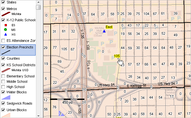
-- view created using CV XE GIS and associated GIS Project
Custom Settings .. goto top
After completing the installation steps, add customized settings as described below.
With the CV XE GIS software running, click Settings>Start-up INI. The Setting form appears as shown
in this section of the User Guide.
Modify the Key edit box and the Start-up GIS project. The values for these two settings are provided separately.
After adding the two values, click the Apply Update and Save Settings buttons and close the Settings form.
Now, when the CV XE GIS software is started the correct authorized CV software features are enabled
and the custom GIS project automatically opens when CV starts.
Optional Add-on Features .. goto top
Student Analytics and Predictive Analytics are available as optional additional features.
Software features are enabled in the CV software.
Student Analytics
The Student Analytic features enables geospatial analysis of students by location.
Student addresses are geocoded and the corresponding point shapefile is added to the GIS project.
A range of student attributes are included in the data record (demographics, school, grade, performance data).
Analytical reports supplement the GIS analyses.
Student location data are important in applications that include school attendance zone realignment.
Student characteristics may be analyzed over time.
Student geocoding may be done internally without releasing confidential data.
Predictive Analytics
The Predictive Analytics feature enables development of projected enrollment by school and grade
with selected demographic breakdowns. Standard 5 year annual projections may be extended to 10 years.
Projections may be done internally using a modeling feature without releasing confidential data.
Alternative scenario projections may be developed with different assumptions.
Projections may be integrated into the school (point) and/or school attendance zone (polygon) shapefiles, mapped and
geospatially analyzed.
Related Resources .. goto top
• CV XE GIS User Guide
• K-12 Schools interactive table
.. view/compare/sort/query all U.S. K-12 public schools.
• School District Demographic Trends interactive table
.. view/compare/sort/query all U.S. school district annual demographic trend data.
• ACS 2015 School District Demographic-Economic Characteristics interactive tables
.. view/compare/sort/query all U.S. school district characteristics.
• ACS 2015 5-year estimates
• ACS 2015 "Itemset1" metadata XLS
• Geographic Reference
.. Census Blocks
.. Block Groups
.. Census Tracts
.. Digital Map Database; Roads
• General Reference
.. Glossary
Things to Know & FAQ .. goto top
• Codes for this school district:
.. Federal school district code: 4818150
.. Federal state+county code: 48029
.. CBSA/metro code: 41700
Support Using these Resources [goto top]
Learn more about demographic economic data and related analytical tools.
Join us in a Data Analytics Lab session.
There is no fee for these Web sessions.
Each informal session is focused on a specific topic.
The open structure also provides for Q&A and discussion of application issues of interest to participants.
ProximityOne User Group [goto top]
Join the ProximityOne User Group
to keep up-to-date with new developments relating to geographic-demographic-economic decision-making information resources.
Receive updates and access to tools and resources available only to members.
Use this form to join the User Group.
Additional Information
ProximityOne develops geodemographic-economic data and analytical tools and helps organizations knit together and use diverse data in a decision-making and analytical framework. We develop custom demographic/economic estimates and projections, develop geographic and geocoded address files, and assist with impact and geospatial analyses.
Wide-ranging organizations use our tools (software, data, methodologies) to analyze their own data integrated with other data.
Follow ProximityOne on Twitter at www.twitter.com/proximityone.
Contact us (888-364-7656) with questions about data covered in this section or to discuss
custom estimates, projections or analyses for your areas of interest.
|