
|
|
|
January 2019. The US1_2019 GIS project is a composite geographic, demographic, economic Geographic Information System project containing new layers for the ProximityOne 2019 vintage US1 project. The GIS project includes all related shapefiles and other data referenced in the GIS project file. US1_2019 is designed for use with the ProximityOne CV XE GIS software but may be used with any GIS software with ability to use shapefiles for mapping and geospatial processing. The US1_2019 GIS project is part of a continually updated, annually oriented, US1_20XX GIS projects; notes on the US1_2020 and US1_2021 GIS projects are provided below. Together, these resources provide a comprehensive Census 2020 data access and use program, integrating these geography and data with others. The US1_20XX GIS projects knit together current demographic-economic estimates and projections from the ProximityOne Situation & Outlook program. Contents 01 US1_2019 GIS Project Overview 02 Start-up View 03 Using the US1 2019 Project 04 Geographic Levels Supported/Included 05 Layers in the Project .. 05a Layer Notes 06 Applications US1_2019 GIS Project Overview .. goto top US1_2019 is available for licensed use during calendar year 2019. US1_2019 is updated throughout 2019 as updates to various layer shapefiles/subject matter data become available. • US1_2020 -- released in January 2020; includes selected Census 2020 geography & demographics • US1_2021 -- released in January 2021; includes most Census 2020 geography & P.L. 94-171 demographics Access & Use US1_2019 may be licensed for use two ways. One, it may be licensed in an as-is state (not updated during year). Two, it may be licensed to receive updates as released (monthly). US1_2019 Start-up View .. goto top The following graphic shows the start-up view of the project file named us1_2019.gis. The view is focused on the Minneapolis-St. Paul area; the cities of Minneapolis and St. Paul are shown with bold brown boundaries. Schools are shown in context of these cities and a thematic pattern map of economic prosperity (median household income - $MHI) by census tract. Click graphic for larger view that shows the $MHI x Tract in the legend highlighted in blue. Expand browser window to full screen for best quality view.  - View developed using CV XE GIS and related GIS project. - Other GIS projects are provided with the US1_2019 installer. Using the US1 2019 Project .. goto top This GIS project may be used with any version of the CV XE GIS software. It is recommended that the US1_2019 zip file be expanded to the folder c:\us1_2019. With CV XE GIS running, use File>Open from the main menu to open c:\us1_2019\us1_2019.gis. It is recommended that US1_2019.GIS not be modified directly as some documentation references may be affected. The project US1_2019.GIS should be immediately saved as c:\us1_2019\us1_2019a.gis and this GIS project be the one that is used. Saved project files should use other project file names meaningful to the application. Geographic Levels Supported/Included .. goto top National Scope; covering all states: • World by Country • U.S. by State • U.S. Primary & Secondary Roads • U.S. Core-Based Statistical Areas (CBSAs) - metros • U.S. Urban Areas • 116th Congressional Districts • U.S. State Legislative Districts • U.S. by County • U.S. by City/Place • U.S. by School District • U.S. K-12 Schools • U.S. by Census Tract • U.S. by Block Group • Census Blocks • Roads - intersection to intersection segments • Voting Precincts Current Vintage Layers -- Version 0112919 .. goto top The following table provides a list of layers included in the current vintage US1_2019 GIS project. This vintage is dated 012919. These layers will change some during 2019 and new version of the project and shapefiles may be downloaded. Caption refers to the name shown in the CV XE GIS legend when the project is opened. LayerName refers to the name used in the GIS project text file. Source Path/Layer refers to the shapefile or other file being used as the source for this layer.
Layer Notes From links in the above layers table ... Places .. goto top .. goto layers table Scope: polygon shapefile with integrated attributes Related Interactive table: Geography: city/place boundaries as of January 1, 2017 updates: Apr 2019 with boundaries as of January 1, 2018 Subject matter: Census sourced estimates through July 1, 2017 updates: Jul 2019 with estimates through July 1, 2018 Schools .. goto top .. goto layers table Scope: point shapefile with integrated attributes Related Interactive table: Geography: K-12 public school locations, 2016-17 school year updates: Apr 2019 with boundaries as of January 1, 2018 Subject matter: school attributes, enrollment, teachers updates: Jan 2020 with data for school year 17-18 Applications .. goto top Illustrative applications/views that can be directly developed with the US1_2019.gis project. Patterns of Economic Prosperity by Census Tract Related section: http://proximityone.com/tracts17dp3.htm The following graphic shows median household income (item E062 in interactive table below) by census tract based on ACS 2017 5 year estimates. Zoom-in view focused on Texas showing Austin-Round Rock, Dallas-Fort Worth, Houston, San Antonio metros with bold red-brown metros. (click link to view Situation & Outlook report), Click graphic for larger view, more detail (shows county layer) and legend color/data intervals. This map illustrates the geographic level of detail available using census tract demographics and the relative ease to gain insights using geospatial data analytics tools.  - View developed using CV XE GIS and related GIS project. Patterns of Economic Prosperity by School District Related section: http://proximityone.com/sd17dp3.htm The following map shows patterns of median household income ($MHI) by school district in the San Antonio, TX MSA (bold brown boundary) area based on the ACS 2017 5-year estimates. Create a similar map for any area in the U.S. and/or variations of this view using the associated GIS project with the CV XE GIS software. Add your own data. 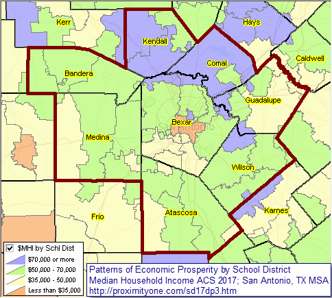 - larger view showing San Antonio city (cross-hatch pattern) - view developed with CV XE GIS software .. click graphic for larger view. Patterns of Economic Prosperity by Congressional District Related section: http://proximityone.com/cd171dp3.htm The following graphic shows patterns of median household income by congressional district in the Los Angeles area. White label shows the congressional district code; yellow label shows median household income. Legend shows color patterns associated with median household income.  - View developed using CV XE GIS software and associated GIS project. - use these resources to develop similar views for any area. Modify subjects, zoom, colors, labels, add your data. Support Using these Resources .. goto top Learn more about accessing and using demographic-economic data and related analytical tools. Join us in a Data Analytics Lab session. There is no fee for these one-hour Web sessions. Each informal session is focused on a specific topic. The open structure also provides for Q&A and discussion of application issues of interest to participants. Additional Information ProximityOne develops geodemographic-economic data and analytical tools and helps organizations knit together and use diverse data in a decision-making and analytical framework. We develop custom demographic/economic estimates and projections, develop geographic and geocoded address files, and assist with impact and geospatial analyses. Wide-ranging organizations use our tools (software, data, methodologies) to analyze their own data integrated with other data. Follow ProximityOne on Twitter at www.twitter.com/proximityone. Contact us (888-364-7656) with questions about data covered in this section or to discuss custom estimates, projections or analyses for your areas of interest. |
|
|