|
|
|
|
.. learning how Michigan demographics are changing .. using interpretative data analytics; tools, data & methods .. topics & insights for stakeholders ... did you know? While the total population of Michigan is projected to change very little between 2020 (10,070,627) and 2030 (10,046,115) or -0.24%, individual counties are projected to experience greater growth and decline. For instance, based on ProximityOne model-based estimates and projections:
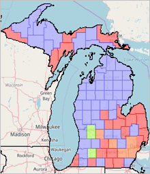
.. and that the dependency ratio in 2020 was 64.96 for Michigan compared to 63.64 for United States? See the full Michigan-United States comparative analysis profile. .. and that Michigan congressional district 07 had 0.6% percent population change, 2020-2022 with 2022 median household income ($MHI) of $74,404. Find out more about MI07 and how it related to other CDs using the interactive table below. Welcome to this section focused on How & Why Michigan Demographics are Changing .. providing data and insights not available elsewhere. This section is not only about demographic-economic characteristics and how they are changing. It also discusses tools that stakeholders can use to examine different geography or subject mattter. This section assumes general familiarity with American Community Survey (ACS), decennial census and related terminology. Much of the data and graphics reviewed in this section have been developed using the ProximityOne CV XE GIS software and related Michigan GIS project. This GIS project may also be accessed online using VDAGIS tools. See more about this section. Web Sessions. This section is designed to be used in the Wednesday web sessions on How & Why [State] Demographics are changing .. see connectivity details here. Learn more about accessing and using census tract, county, metro, school/school district, congressional district and state legislative district demographics and demographic change. The Wednesday sessions also include a new geography to examine district demographics and demographic change – the congressional community. New Web Session Supplemental Topics Schedule (new data & tools) 05.15.24. Housing Unit 2020-2024 Change by Census Block 05.15.24. Patterns of Housing Price Index by ZIP Code 05.22.24. How Michigan City & Township Population are Changing; Vintage 2023 Estimates 05.29.24. Michigan School District Community Demographics (augmented DA2) 06.05.24. Michigsn County Establishments, Employment & Wages 23Q4, Annual 2023 & Change 06.12.24. Michigsn Congressional Communities ACS 2022 Updates 06.19.24. Michigan 2024 State Legislative District Updates 06.26.24. Michigan 2023 Vintage County Demographic Change by Age-Race/Origin-Gender Topics 01. How & Why Michigan Demographics are Changing 02. Changing Michigan State Legislative Districts 03. Michigan Congressional District 07 04. Michigan Demographics .. Comparing MI07 with Michigan 05. Michigan Demographics .. Demographic Profiles (DA2) 06. Age-Gender Characteristics .. Population Pyramids 07. Congressional District 2020/2022 Demographics Interactive Table 08. Voter Demographics 08.1. Voter Turnout & Registration 08.2. Examining Voter Demographics using VDAGIS 09. Michigan County Economic Characteristics & Change 10. GeoSpatial Analytics: Using Geographic Information System Tools & Data 11. Michigan Congressional Communities 12. Data Analytics Package 13. About 14. Terms of Use Congressional Communities, as mentioned above, are a new geography being introduced by the nonprofit of the same name. Congressional districts are sub-divided into Congressional Communities (CCs), sets of contiguous blocks/block groups, that are typically around 45,000 population based on a range of socioeconomic, geopolitical features, geographic and other factors. The approximate 7,400 Congressional Communities cover the United States wall-to-wall and nest exactly within the corresponding congressional district. CC demographic and geographic makeup of CCs often differ from the corresponding congressional district. CC offer the opportunity for CC residents/stakeholder to better have their voices heard by congressional policy-makers and other legislative entities. A set of Census 2020 and American Community Survey demographics are developed for each CC. These demographics help CC stakeholders better understand characteristics and needs of their CCs and other CCs. 01. How & Why Michigan Demographics are Changing .. goto top Using Demographic-Economic Data Explorer (DEDE2) to access/show Michigan demographic trends Michigan demographic annual 2010-2022 trend profile of selected annual American Community Survey 1-year data (ACS). The table shows a row for each ACS program year 2010 through 2022. Subject matter extracted from the ACS detailed summary file data are shown across the columns. ACS 2021 detailed estimates were not published for 2021 due to pandemic impact on data quality. For example, the highlighted cell in the table shows that the ACS 2022 1-year total population estimate was 10,034,118. Show use of DEDE2 operation. Use DEDE2 to create trend profiles for most types of ACS geography for annual ACS program 2010 through most recent ACS release. Click graphic to open in Excel 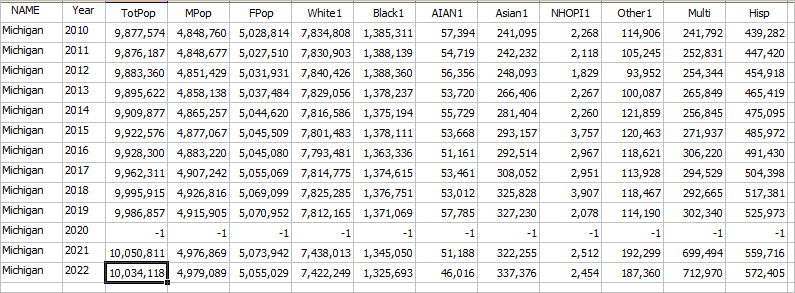 01.1. How & Why Michigan County Demographics are Changing The following graphic shows how and why the Michigan county population is changing from 2020 to 2023 based on Census Bureau sourced model-based estimates. The inset legend shows the relation of color patterns to how and why county population is changing. See more about county demographic change interactive table. 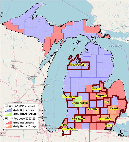
01.2. How & Why Michigan 2023 Vintage Metro Demographics are Changing The following graphic shows how and why the Michigan 2023 vintage metro population is changing from 2020 to 2023 based on Census Bureau sourced model-based estimates. The inset legend shows the relation of color patterns to how and why metro (MSAs) population is changing. See more about metro demographic change interactive table. d:\_metrodynamics\metrodynamics_fresno_sf.gis 
There are 15 2023 vintage MSAs in Michigan. Use the Metros Interactive Table to create variations on the view shown in the following graphic. This table has been sorted on percent change in population 2020-2023 in descending order. Create your own rankings/comparative analyses. 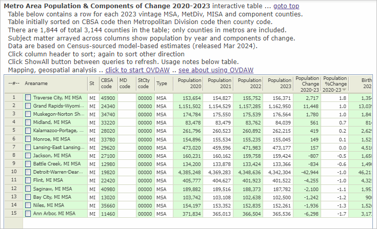
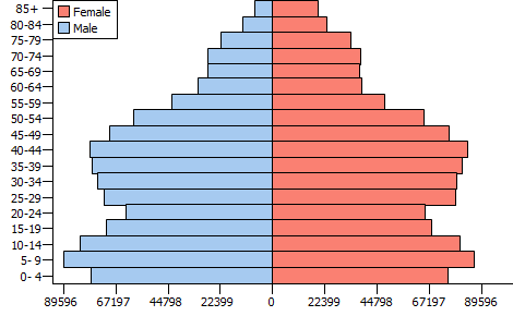
02. Changing Michigan State Legislative Districts -- 2024 Updates .. goto top All 110 state House districts are up for reelection this year with party control on the line. As a result of the special general election on April 16, the Democrats now have a 56-54 seat advantage. The MICRC will now redraw six state Senate districts. It has approved a tentative timeline to craft maps and seek public input starting April 12 and concluding by July 30. Most Senate seats will not be on the ballot until 2026. See more. Michigan House SLDs in context of CD 07 bold boundary:CD .. green boundary: new House SLDs .. black boundary: previous House SLDs .. House SLDs in CD 07 do not change .. the situation in Dearborn and elsewhere is quite different. 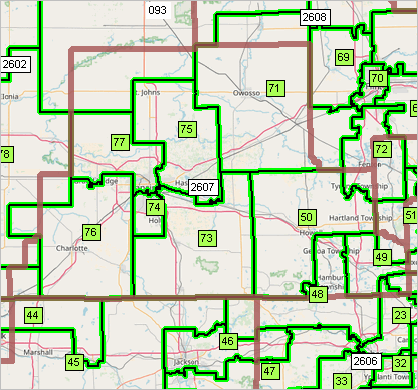 Michigan House SLDs in context of CD 07 & Patterns of Economic Prosperity bold boundary:CD .. green boundary: new House SLDs .. black boundary: previous House SLDs .. in context of patterns of economic prosperity by census tract 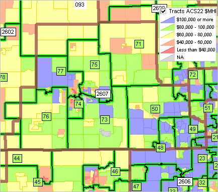 03. Michigan Congressional District 07 .. goto top Click here to view your location in context of MI07. Michigan Congressional District 07 -- Patterns of Economic Prosperity .. this graphic shows CDs with bold brown boundary and zoom-in to CD MI07. .. counties shown county name as label and with black boundary. .. patterns of median household income, see inset legend, shown by census tract. 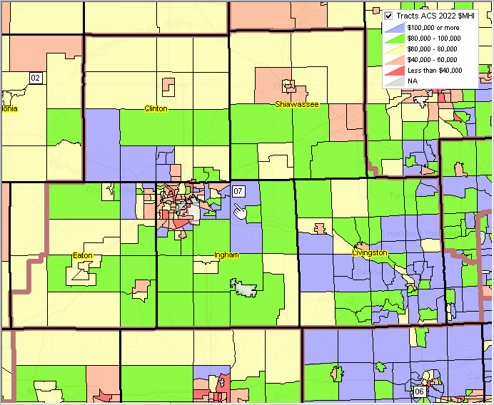 .. click graphic for larger view (desktop with full-screen browser recommended). .. view developed using VDA GIS tools. 04. Michigan Demographics .. Comparing MI07 with Michigan .. goto top The America's Demographics tool allows users to generate analysis reports that compare key demographics between user selected areas. The narrative provides insightful information in a talking-points layout. The HTML reports are created in tabular and narrative structures. The following "Tabular Report” and “Narrative Report” narrative and tabular reports compare MI07 Michigan’s 7th Congressional District with the entire state. As an example of the power of the narrative report, the user can see that the diversity index in 2020 was 35.2% for CD118 MI07 compared to 45.2% for Michigan, and that the dependency ratio in 2020 was 61.60 for CD118 MI07 compared to 64.96 for Michigan • Tabular Report • Narrative Report Request a America's Demographic report for different geographic comparisons. For example, compare an MI07 Congressional Community to MI07. 05. Michigan Demographics .. Demographic Profiles .. goto top Use the Demographic Analytics (DA2) tool to develop demographic profiles for user specified geographic summary levels. Click links shown below to view selected profile sets for selected areas. These profiles are based on ACS2022 data. The DA2 user may select ACS 1-year or 5-year data. These web-based HTML versions can also be created using in XLS format using DA2. Note: for areas over 65,000 population, data are available based ACS 2022 1-year and 5-year estimates. For State Legislative Districts (SLDs), data are available for ACS 2022 5-year estimates. • Allen Park, MI ACS2022 5 year • Detroit, MI ACS2022 1 year • Detroit, MI ACS2022 5 year • Wayne County, MI ACS2022 5-year • Wayne County, MI ACS2022 1-year • Lansing, MI ACS2022 1-year • Detroit, MI ACS2022 1-year • State Legislative District Lower MI 036 ACS2022 5-year • State Legislative District Lower MI 042 ACS2022 5 year • Congressional District MI 07 ACS2022 5-year • Congressional District MI 07 ACS2022 1 year • Congressional District MI 08 ACS2022 5-year • Congressional District MI 08 ACS2022 1 year • Congressional District MI 13 ACS2022 5-year • Congressional District MI 13 ACS2022 1 year • Congressional District CA 47 ACS2022 5 year • Congressional District CA 47 ACS2022 1 year • Orange County, CA ACS2022 5-year • Orange County, CA ACS2022 1-year • Michigan ACS2022 1 year • Michigan ACS2022 5 year • United States ACS2022 1 year • United States ACS2022 5 year 06. Age-Gender-Race/Origin Characteristics .. Population Pyramids .. goto top Use the Chartgraphics tool to develop age-gender population pyramids for user specified geographic summary levels and race/origin combinations. Unlike other population pyramids, the Chartgraphics user may select from a set of selected national scope summary levels (including congressional communities and congressionl districts among others) for different time periods. Chartgraphics is unique in that enables the user to add custom age-gender-race/origin profiles. Population Pyramid for Congressional District MI07 Click graphic to view the expanded profile showing data in a tabular format. There is a relatively larger young adult population reflecting the city of Lansing and Michigan State University. 
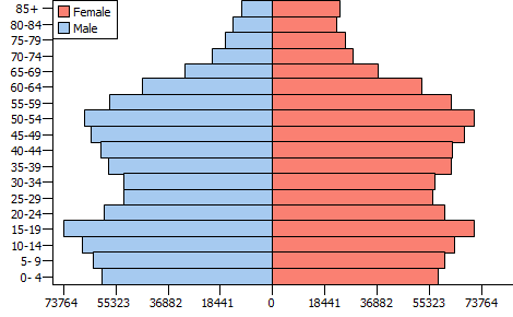
Population Pyramids for Wayne County, MI .. 20 years of Change .. examining how the age-gender population is changing over time. .. click graphic to view the expanded profile showing data in a tabular format.
 .. ..
 .. ..
Request an Age-Gender report for a different geographic area .. for example, a MI07 Congressional Community. 07. Congressional District 2020/2022 Demographics Interactive Table .. goto top Incumbent data shown in table has been updated through 2/14/24. Use the buttons & tools below the table for most effective use of this table and data. Click ShowAll button between Find/Queries. Use mouseover on column header to view column description. See usage notes below table. Usage Notes Most of the items in this table are based on American Community Survey 2022 1 year (ACS2022) estimates. .. those estimates are new as of 9/14/23 and will the most current CD118 demographic estimates until 9/24. The table also contains the Census 2020 population and shows the population change 2020 to 2022. • If table not showing any rows; click ShowAll button below table. • Use vertical and horizontal scroll bars to navigate up/down or left/right. • Adjust column widths using column divider between header cells. Items in Table
- Incumbent
- Stab USPS state abbreviation - St State FIPS code - CD Congressional Districts code - StCD State FIPS and Congressional Districts code - Party - Population 2020 - Population 2022 - Population Change 2020-2022 - Population %Change 2020-2022 - Male, 2022 - Female, 2022 - White alone, 2022 - Black alone 2022 - AmerInd/AlNat alone, 2022 - Asian alone 2022 - NHOPI1 alone 2022 - OthRace 2022 - MultiRace, 2022 - Hispanic, 2022 - Pop 65+ 2022 - Pop in HH 2022 - Households 2022 - Families 2022 - Pop 25+ 2022 - HS Grads M 2022 - HS Grads F 2022 - Total Housing Units 2022 - Own Occ Hsg Units 2022 - Rnt Occ Hsg Units 2022 - Vacant units 2022 - Med HH Income 2022 - Med Fam Income 2022 - Med Hsg Value 2022 - Med Rent 2022 - Gini Index 2022 - CD Name 08. Voter Demographics .. goto top 08.1 Voter Turnout & Registration Voter turnout for the 2022 U.S. congressional elections was the second highest for a nonpresidential election year since 2000, with 52.2% of the citizen voting age population participating. Voter registration rates were the highest for a midterm election since 2000, with 69.1% of the citizen voting age population registered to vote, up 2.2 percentage points from 66.9% in 2018. These data are based the Current Population Survey (CPS). For the 2022 elections, 31.8% of all voters cast ballots by mail, up from 23.1% in 2018. 47.1% voted before Election Day, up from 37.8% in 2018. 2022 CPS Voting & Registration Supplement .. "total population" in the table is total population 18 years and over 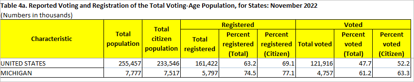
08.2 Examining Voting Demographics using VDAGIS .. goto top Geographic Information Systems (about GIS) enable the user to dynamically, flexibly create maps and perform geospatial analyses. You can use various VDA tools to examine voter and related demographics for anywhere in the U.S. Use the Open VDA Web GIS .. see more about OVDAW The following application provides an example focused on Citizen Voting Age Population (CVAP) by census tract in the Allen Park, MI (Detroit) area using Open VDA Web GIS. All you need is a browser and Internet (mobile devices not recommended due to screen size). No registration or login required. Nothing to install. The CVAP for an area tells us the size of the population eligible to vote in an area, such as a census tract. If all residents of an area are citizens, the CVAP would be close to the number of registered voters and enable maximized voter turnout. For some applications, CVAP might be expressed as a percentage of the total population. CVAP data are statistics developed from the American Community Survey (ACS2022) and subject to errors of estimation. Voter registration data are developed from administrative data and subject to a range of other accuracy issues. Despite the inherent estimation errors, CVAP is an important piece of information, particularly for voter registration drives, get out the vote efforts, advocacy outreach, and voter registrars. When layered with registered voter files, VDA tools can allow users to quickly identify areas with concentrations of unregistered voters as well as bloated voter rolls. Proceed with these steps: 1. Click to start OVDAW 2. Key "Allen Park, MI" (no quotes; any address also works, or latitude,longitude) into search bar and press Enter .. the map refreshes with a zoom to that location and shows the location with a blue marker. 3. In the legend panel at left, check on the "Tracts Code" layer. 4. Add Table/Grid view: click circle-A button at right below map window 5. Queries Queries operate on the tabular data restricting the scope of data to exactly what is relevant to the anlaysis. Even though writing queries requires some basic coding skills, queries unleash the ability to explore the data the user wants to see. Many websites that provide data, do not give the user this flexiblity. In this example, we are going to locate all census tracks in Wayne County, MI, that have a Citizen Voting Age Population (CVAP) that exceeds 40% of the tract population. We will also restrict the scope of data to include only tracts that have a total population of 4,000 people or more. In other words, we will only see tracts that show CVAP of 1,600 people or more (40% of 4,000+). The selection of 40% is somewhat arbitrary .. we want to examine tracts with a relatively high CVAP%. The selection of 4,000 population is somewhat arbitrary .. we want to examine larger tracts. How to create and run a query Add Query settings (in the SQL Filter box above the table): Query (copy the following line and paste into the SQL Filter edit box): select geoid, d001, d089, 100*d089/d001 where d001>4000 and geoid like '26163%' and 100*d089/d001>=40 Sort (copy the following line and paste into the SORT edit box to right of SQL Filter edit box): 100*d089/d001 desc Click query button; view should appear similar to view below. Explanation of the query used Reference to "geoid like '26163%'" says to limit the scope of geography to state+county 26163 (Wayne County, MI) Reference to "100*d089/d001>=40" says to show only tracts where percent CVAP is greater that 40% D089 is the Citzen Voting Age Population (CVAP) D001 is the total population CVAP Patterns by Tract; Allen Park, MI Area .. goto top The graphic below is a screen capture of OVDAW showing a zoom-in to the Allen Park, MI area. The map graphic shows census tracts labeled with census tract code. Optionally click an artibrary tract; it highlights and profile is shown at lower left in graphic. 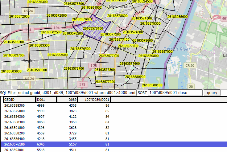
Click to view an extended view of settings. For example, click the tract labeled 26163576100 (census tract code) in the map; a profile appears in the lower left. Click the HTML button below the profile; an organized display of the subject matter items appears in a new tab. See on line "D089" that the Citizen Voting Age Population is 5,157 in this tract. Increasing voter turnout .. actionable steps from these analytics. 1. from the table, tracts with a high %CVAP are known ("new information") -- the voter registration for these tracts might be compared to the CVAP number. -- if the voter registration is far below the CVAP, these areas/tracts might be prioritized for maximizing voter turnout. 2. from the map, the areas/tracts with the higher %CVAP can be visually idenfified. 09. Michigan County Economic Characteristics & Change .. goto top More than demographics ... using the Regional Economic Information System .. select any county; click links below for illlustrative views of REIS profiles for Wayn County, MI Regional Economic Information System (REIS) - REIS Table CA45 for Wayne County, MI. • Table CA4 - Personal Income by Major Source • Table CA5 - Earnings by Source & Sector • Table CA25 - Employment by Sector • Table CA30 - Economic Profile • Table CA35 - Transfer Payments • Table CA45 - Farm Income & Expenditures 10. Michigan GIS Project .. goto top The following graphic shows the CV XE GIS start-up view using the Michigan GIS project. Patterns of Michigan County Percent Population Change, 2020-2030 The following graphic shows Michigan county percent population change from 2020 to 2030. The highlighted layer in the legend panel "Cty %PopChg 2020-2030" shows color patterns associated with percent population change intervals during the period. 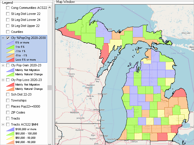
The above view was developed using the CV XE GIS software with related Michigan GIS project and files. About GIS. Register here to use the VDAGIS tools and files. 11. Michigan Congressional Communities & Patterns of Population 65 Years and Older .. goto top .. this graphic shows CDs with bold brown boundary and zoom-in to CD MI07. .. Congressional Communities (CCs) show CC codes as label and with black boundary. .. patterns of percent population over 65 years of age, see inset legend, shown by census tract. 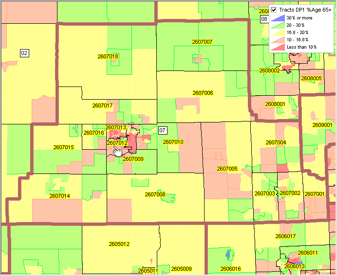 .. click graphic for larger view (desktop with full-screen browser recommended). .. view developed using VDA GIS tools. 12. Data Analytics Package .. goto top The following tools and data are available to coordinators of Communities Communities: • CV XE GIS and related GIS project and datasets • Open VDA Web GIS • Chartgraphics and related datasets • Data Analytics (DA & DA2) • Demographic Economic Data Explorer (DEDE2) 13. About this Section .. goto top The 118th Congress runs from January 1, 2023 through December 31, 2024. The 2024 House of Representatives elections will be held on November 5, 2024, to elect representatives from all 435 congressional districts for the 119th Congress. Those elected will serve in the 119th Congress with seats apportioned among the states based on the Census 2020. Using census block level data from Census 2020 each state redistricts their apportioned number seats with new boundaries for the 2024 elections. While most 119th congressional district boundaries will be the same as the 118th CD boundaries, some change occur due to 2024 redistricted states. The 118th CD boundaries are provided to the Census Bureau by states and are integrated into the TIGER public use digital map database released in 2023. More detailed 118th congressional district demographic-economic data are available from the ACS 2022 released in 2023. This section is developed/updated by Warren Glimpse .. connect via LinkedIn. Schedule a talk/briefing by Warren for your group (face-to-face or Web) on Census-related topics, Census 2020, congressional districts, redistricting or related topics -- adjusted to your theme or sphere of interest. Send a message via LinkedIn, use this form (add note in text section) or call 888.364.7656. Terms of Use .. goto top There are no warranties about any aspect of this web section, related sections, data. The user is responsible for any use of any aspect of this web section or related sections or data. Support Using these Resources .. goto top Learn more about accessing and using demographic-economic data and related analytical tools. Join us in a Data Analytics Lab session. There is no fee for these one-hour Web sessions. Each informal session is focused on a specific topic. The open structure also provides for Q&A and discussion of application issues of interest to participants. ProximityOne User Group Join the ProximityOne User Group to keep up-to-date with new developments relating to geographic-demographic-economic decision-making information resources. Receive updates and access to tools and resources available only to members. Use this form to join the User Group. Additional Information ProximityOne develops geographic-demographic-economic data and analytical tools and helps organizations knit together and use diverse data in a decision-making and analytical framework. We develop custom demographic/economic estimates and projections, develop geographic and geocoded address files, and assist with impact and geospatial analyses. Wide-ranging organizations use our tools (software, data, methodologies) to analyze their own data integrated with other data. Follow ProximityOne on Twitter at www.twitter.com/proximityone. Contact ProximityOne (888-364-7656) with questions about data covered in this section or to discuss custom estimates, projections or analyses for your areas of interest. |
|
|