|
|
Decision-Making Information

|
ProximityOne
information resources & solutions
(888) DMI-SOLN
(888) 364-7656
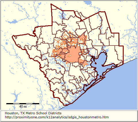
Houston Metro School Districts
patterns of economic prosperity
by neighborhood
|
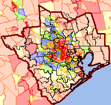
Houston, TX Metro K-12 Analytics
... School District GeoDemographic Information System
... data analytics tools for K-12 schools & school districts
.. join us in the Houston metro demographic-economic outlook 2022/2060 webinar on November 28, 2017,
where Warren Glimpse reviews current trends and short/long-term projections
for the Houston metro
down to the census tract geographic level. Session includes review of school districts described below in this section.
Register here.
This section provides information about the structure and use of the
Houston, TX Metro K-12 Analytics tools and data.
The Houston metro K-12 Analytics uses the
School District GeoDemographic Information System
(SDGIS) integrated software and database package.
Using GIS technologies,
SDGIS is developed for use by schools, school districts, education agencies and stakeholder organizations.
ProximityOne develops, deploys and supports SDGIS tailored to the individual school/education agency structure and needs.
Individual SDGIS packages are structured around a set of data that are unique in geographic scope and typically
focused on one or a set of school districts.
Focused SDGIS Project on any District/School
See related more drill-down SDGIS project for Fort Bend ISD, TX.
- available for any school district/school.
Contents
• Metro Districts & Profile Links
• SDGIS Start-up View
• SDGIS GIS Project -- Structure & Layers
• K-12 Schools Interactive Table
• SDGIS Installation
• Custom Settings
• Optional Add-on Features
• Related Resources
• Things to Know & FAQ
Houston, TX Metro School Districts - Population Ages 5-17; 2010-2015 .. goto top
The total school age population of the 62 school districts comprising the Houston, TX Metro changed from
1,179,961 in 2010 to 1,298,667 in 2015, an increase of 118,706 (10.1%).
Individual districts are shown in the table presented below.
Click the link in the code column to view a demographic-economic characteristics and trends profile for that district.
See these data for any school district in this related section.
| Name | Code | Population
Age 5-17
2010 |
Population
Age 5-17
2015 |
Population
Age 5-17
Chg1015 |
Population
Age 5-17
%Chg1015 |
| Aldine ISD |
4807710 |
60,890 |
65,766 |
4,876 |
8.0 |
| Alief ISD |
4807830 |
50,421 |
54,281 |
3,860 |
7.7 |
| Alvin ISD |
4808090 |
17,083 |
18,667 |
1,584 |
9.3 |
| Anahuac ISD |
4808190 |
1,267 |
1,360 |
93 |
7.3 |
| Angleton ISD |
4808310 |
6,507 |
7,109 |
602 |
9.3 |
| Barbers Hill ISD |
4809450 |
3,396 |
3,644 |
248 |
7.3 |
| Bellville ISD |
4809810 |
2,190 |
2,231 |
41 |
1.9 |
| Brazos ISD |
4844470 |
834 |
903 |
69 |
8.3 |
| Brazosport ISD |
4811190 |
12,719 |
13,897 |
1178 |
9.3 |
| Channelview ISD |
4813590 |
9,024 |
9,710 |
686 |
7.6 |
| Clear Creek ISD |
4814280 |
40,580 |
43,688 |
3,108 |
7.7 |
| Cleveland ISD |
4814370 |
4,049 |
4,134 |
85 |
2.1 |
| Columbia-Brazoria ISD |
4814670 |
3,496 |
3,819 |
323 |
9.2 |
| Conroe ISD |
4815000 |
53,099 |
61,071 |
7,972 |
15.0 |
| Crosby ISD |
4815750 |
5,058 |
5,441 |
383 |
7.6 |
| Cypress-Fairbanks ISD |
4816110 |
108,989 |
117,289 |
8,300 |
7.6 |
| Damon ISD |
4816260 |
247 |
270 |
23 |
9.3 |
| Danbury ISD |
4816290 |
755 |
825 |
70 |
9.3 |
| Dayton ISD |
4816410 |
4,978 |
5,124 |
146 |
2.9 |
| Deer Park ISD |
4816530 |
10,328 |
10,907 |
579 |
5.6 |
| Devers ISD |
4816920 |
185 |
191 |
6 |
3.2 |
| Dickinson ISD |
4817070 |
9,448 |
10,191 |
743 |
7.9 |
| East Chambers ISD |
4817880 |
1,253 |
1,345 |
92 |
7.3 |
| Fort Bend ISD |
4819650 |
77,110 |
88,667 |
11,557 |
15.0 |
| Friendswood ISD |
4819950 |
5,976 |
6,448 |
472 |
7.9 |
| Galena Park ISD |
4820250 |
19,486 |
20,992 |
1,506 |
7.7 |
| Galveston ISD |
4820280 |
6,745 |
7,276 |
531 |
7.9 |
| Goose Creek CISD |
4821150 |
20,823 |
22,404 |
1,581 |
7.6 |
| Hardin ISD |
4822380 |
1,297 |
1,334 |
37 |
2.9 |
| Hempstead ISD |
4822920 |
1,714 |
1,975 |
261 |
15.2 |
| High Island ISD |
4823160 |
67 |
72 |
5 |
7.5 |
| Hitchcock ISD |
4823310 |
1,493 |
1,611 |
118 |
7.9 |
| Houston ISD |
4823640 |
218,506 |
246,263 |
27,757 |
12.7 |
| Huffman ISD |
4823820 |
3,150 |
3,391 |
241 |
7.7 |
| Hull-Daisetta ISD |
4823880 |
542 |
557 |
15 |
2.8 |
| Humble ISD |
4823910 |
35,692 |
38,381 |
2,689 |
7.5 |
| Katy ISD |
4825170 |
60,828 |
67,055 |
6,227 |
10.2 |
| Klein ISD |
4825740 |
47,255 |
50,868 |
3,613 |
7.6 |
| La Marque ISD |
4826160 |
4,598 |
4,959 |
361 |
7.9 |
| La Porte ISD |
4826190 |
8,542 |
9,197 |
655 |
7.7 |
| Lamar CISD |
4826580 |
25,822 |
29,900 |
4,078 |
15.8 |
| Liberty ISD |
4827450 |
2,068 |
2,128 |
60 |
2.9 |
| Magnolia ISD |
4828740 |
12,043 |
13,857 |
1,814 |
15.1 |
| Montgomery ISD |
4831260 |
6,906 |
7,945 |
1,039 |
15.0 |
| Needville ISD |
4832310 |
2,715 |
3,124 |
409 |
15.1 |
| New Caney ISD |
4832400 |
9,967 |
11,456 |
1,489 |
14.9 |
| Pasadena ISD |
4834320 |
53,498 |
57,862 |
4,364 |
8.2 |
| Pearland ISD |
4834440 |
19,996 |
21,808 |
1,812 |
9.1 |
| Royal ISD |
4838190 |
2,114 |
2,436 |
322 |
15.2 |
| Santa Fe ISD |
4839270 |
4,611 |
4,974 |
363 |
7.9 |
| Sealy ISD |
4839630 |
2,558 |
2,604 |
46 |
1.8 |
| Sheldon ISD |
4839990 |
7,488 |
8,066 |
578 |
7.7 |
| Splendora ISD |
4841070 |
3,114 |
3,609 |
495 |
15.9 |
| Spring Branch ISD |
4841100 |
34,057 |
36,703 |
2,646 |
7.8 |
| Spring ISD |
4841220 |
36,307 |
39,103 |
2,796 |
7.7 |
| Stafford Municipal SD |
4841350 |
3,006 |
3,470 |
464 |
15.4 |
| Sweeny ISD |
4841970 |
1,973 |
2,157 |
184 |
9.3 |
| Tarkington ISD |
4842210 |
1,829 |
1,882 |
53 |
2.9 |
| Texas City ISD |
4842510 |
5,476 |
5,906 |
430 |
7.9 |
| Tomball ISD |
4842960 |
11,159 |
12,053 |
894 |
8.0 |
| Waller ISD |
4844430 |
5,749 |
6,431 |
682 |
11.9 |
| Willis ISD |
4845900 |
6,885 |
7,880 |
995 |
14.5 |
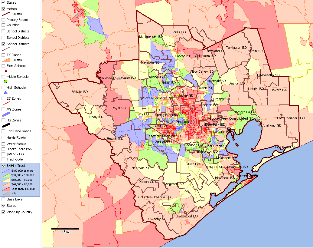
Houston, TX Metro SDGIS Start-up View .. goto top
- School Districts shown with bold brown boundary,
- See more about the Houston-The Woodlands-Sugar Land metro.
- click graphic for larger view showing district names.
-- view created using CVGIS and associated SDGIS Project
Additional Demographic-Economic Characteristics - click link to view
- Houston city, TX demographic-economic profile
- See profiles for other cities
Additional Map Views from SDGIS & Related Projects - click link to view
• Houston Urbanized Area in context of metro.
• Patterns of Economic Prosperity by Neighborhood ($MHI x Census Tract)
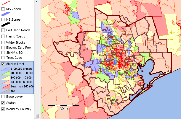
-- view created using CVGIS and associated SDGIS Project
U.S. National Scope K-12 Public Schools, 2014-15 -- Interactive Table .. goto top
Click ShowAll button between Find/Queries; click LEAID button below table to view only schools for selected district.
Use mouseover on column header to view column description.
See usage notes below table.
See related interactive tables.
Usage Notes
Click Show All/Refresh button between queries.
Click Show All/Refresh button ... then click LEAID button below table to select only Fort Bend ISD schools
.. use any Federal school district geocode (7 characters) to view schools for that district (all U.S.).
Click Show All/Refresh button ... then click City button below table to select only "Sugar Land" schools
.. use any city Federal geocode (7 characters) to view schools for that city (all U.S.).
Click Show All/Refresh button ... then click StCty button below table to select only Fort Bend County schools
.. use any State+County FIPS geocode (5 characters) to view schools for that county (all U.S.).
Click Show All/Refresh button ... then click ZIP button below table to select only schools in ZIP 77479
.. enter any ZIP code (5 characters) to view schools for that ZIP code (all U.S.).
Negative values indicate data NA. -2 indicates data not applicable for this area for this subject matter item.
See more information about these data and using the tools in the K-12 schools main section.
.. that page provides more details about codes, subject matter items and usage.
SDGIS GIS Project .. goto top
The SDGIS GIS project file is a text file that contains a list of layers that may be viewed when the
GIS project file is opened using the CV XE GIS software.
Layers included is the Houston Metro SDGIS are described below. Using the CV XE GIS software, layers may be removed, added or attributes modified.
| Layer# | Name | Shapefile/Resource |
| 1 | States1 | cb_2016_us_state_500k.shp |
| 2 | Primary Roads US | tl_2016_us_primaryroads.shp |
| 3 | CBSAs U.S. | cb_2016_us_cbsa_500k.shp |
| 4 | Counties U.S. | cb_2016_us_county_500k_pop2016.shp |
| 5 | Cities/places statewide | cb_2016_houstonmetro_place_500k.shp |
| 6 | School districts state1 | sd1516_ussd1015_houstonmetro.shp |
| 7 | Schools state1 | sch1415_2017pts_houstonmetro.shp |
| 8 | Schools state2 | sch1415_2017pts_houstonmetro.shp |
| 9 | Schools state3 | sch1415_2017pts_houstonmetro.shp |
| 10 | SAZ2 | saz1314nad83_houstonmetro.shp |
| 11 | SAZ1 | saz1314nad83_houstonmetro.shp |
| 12 | SAZ | saz1314nad83_houstonmetro.shp |
| 13 | Butler roads | tl_2016_houstonmetro001_edges.shp |
| 14 | State blocks | tabblock2010_houstonmetro_pophu.shp |
| 15 | block groups statewide | cb_2016_houstonmetro_bg_500k.shp |
| 16 | tracts statewide2 | cb_2016_houstonmetro_tract_500k_acs15itemset1.shp |
| 17 | tracts statewide1 | cb_2016_houstonmetro_tract_500k_acs15itemset1.shp |
| 18 | States2 | cb_2015_us_state_500k.shp |
| 19 | World countries | world_countries.shp |
Layer File Layout/Fields -- scroll section within master scroll section
-- additional field level details are provided to licensed users. Example for school & tract layers:
Schools
| 7-1 | NCESSCH | C, 12, 0 |
| 7-2 | FIPST | C, 2, 0 |
| 7-3 | STABR | C, 2, 0 |
| 7-4 | STATENAME | C, 24, 0 |
| 7-5 | SEANAME | C, 59, 0 |
| 7-6 | LEAID | C, 7, 0 |
| 7-7 | ST_LEAID | C, 14, 0 |
| 7-8 | LEA_NAME | C, 60, 0 |
| 7-9 | SCHID | C, 5, 0 |
| 7-10 | ST_SCHID | C, 20, 0 |
| 7-11 | FEDSCHID | C, 12, 0 |
| 7-12 | SCH_NAME | C, 60, 0 |
| 7-13 | MSTREET | C, 30, 0 |
| 7-14 | MCITY | C, 26, 0 |
| 7-15 | MSTATE | C, 2, 0 |
| 7-16 | MZIP | C, 5, 0 |
| 7-17 | MZIP4 | C, 4, 0 |
| 7-18 | PHONE | C, 10, 0 |
| 7-19 | LSTREET | C, 30, 0 |
| 7-20 | LCITY | C, 26, 0 |
| 7-21 | LSTATE | C, 2, 0 |
| 7-22 | LZIP | C, 5, 0 |
| 7-23 | LZIP4 | C, 4, 0 |
| 7-24 | UNION | C, 3, 0 |
| 7-25 | OUTOFST | C, 1, 0 |
| 7-26 | SCH_TYPEC | C, 28, 0 |
| 7-27 | SCH_TYPE | C, 1, 0 |
| 7-28 | RECON_STA | C, 3, 0 |
| 7-29 | GSLO | C, 2, 0 |
| 7-30 | GSHI | C, 2, 0 |
| 7-31 | LEVEL | C, 1, 0 |
| 7-32 | VIRTUAL | C, 7, 0 |
| 7-33 | BIES | C, 1, 0 |
| 7-34 | SY_STAT | C, 1, 0 |
| 7-35 | CHARTERTYP | C, 14, 0 |
| 7-36 | PKOFFERED | C, 1, 0 |
| 7-37 | KGOFFERED | C, 1, 0 |
| 7-38 | G1OFFERED | C, 1, 0 |
| 7-39 | G2OFFERED | C, 1, 0 |
| 7-40 | G3OFFERED | C, 1, 0 |
| 7-41 | G4OFFERED | C, 1, 0 |
| 7-42 | G5OFFERED | C, 1, 0 |
| 7-43 | G6OFFERED | C, 1, 0 |
| 7-44 | G7OFFERED | C, 1, 0 |
| 7-45 | G8OFFERED | C, 1, 0 |
| 7-46 | G9OFFERED | C, 1, 0 |
| 7-47 | G10OFFERE | C, 1, 0 |
| 7-48 | G11OFFERE | C, 1, 0 |
| 7-49 | G12OFFERE | C, 1, 0 |
| 7-50 | G13OFFERE | C, 1, 0 |
| 7-51 | AEOFFERED | C, 1, 0 |
| 7-52 | UGOFFERED | C, 1, 0 |
| 7-53 | NOGRADES | C, 1, 0 |
| 7-54 | IGOFFERED | C, 1, 0 |
| 7-55 | TOTFRL | C, 4, 0 |
| 7-56 | FRELCH | C, 4, 0 |
| 7-57 | REDLCH | C, 4, 0 |
| 7-58 | PK | C, 4, 0 |
| 7-59 | KG | C, 3, 0 |
| 7-60 | G01 | C, 3, 0 |
| 7-61 | G02 | C, 3, 0 |
| 7-62 | G03 | C, 3, 0 |
| 7-63 | G04 | C, 3, 0 |
| 7-64 | G05 | C, 4, 0 |
| 7-65 | G06 | C, 4, 0 |
| 7-66 | G07 | C, 4, 0 |
| 7-67 | G08 | C, 4, 0 |
| 7-68 | G09 | C, 4, 0 |
| 7-69 | G10 | C, 4, 0 |
| 7-70 | G11 | C, 4, 0 |
| 7-71 | G12 | C, 4, 0 |
| 7-72 | G13 | C, 2, 0 |
| 7-73 | UG | C, 4, 0 |
| 7-74 | AE | C, 4, 0 |
| 7-75 | TOTAL | C, 5, 0 |
| 7-76 | MEMBER | C, 5, 0 |
| 7-77 | AM | C, 4, 0 |
| 7-78 | AMALM | C, 3, 0 |
| 7-79 | AMALF | C, 3, 0 |
| 7-80 | AS | C, 4, 0 |
| 7-81 | ASALM | C, 4, 0 |
| 7-82 | ASALF | C, 4, 0 |
| 7-83 | HI | C, 4, 0 |
| 7-84 | HIALM | C, 4, 0 |
| 7-85 | HIALF | C, 4, 0 |
| 7-86 | BL | C, 4, 0 |
| 7-87 | BLALM | C, 4, 0 |
| 7-88 | BLALF | C, 4, 0 |
| 7-89 | WH | C, 5, 0 |
| 7-90 | WHALM | C, 4, 0 |
| 7-91 | WHALF | C, 4, 0 |
| 7-92 | HP | C, 4, 0 |
| 7-93 | HPALM | C, 3, 0 |
| 7-94 | HPALF | C, 3, 0 |
| 7-95 | TR | C, 4, 0 |
| 7-96 | TRALM | C, 3, 0 |
| 7-97 | TRALF | C, 3, 0 |
| 7-98 | TITLEI_STA | C, 1, 0 |
| 7-99 | TITLEI | C, 1, 0 |
| 7-100 | STITLEI | C, 1, 0 |
| 7-101 | SHAREDTIME | C, 7, 0 |
| 7-102 | MAGNET1 | C, 14, 0 |
Census tracts
| 16-1 | STATEFP | C, 2, 0 |
| 16-2 | COUNTYFP | C, 3, 0 |
| 16-3 | TRACTCE | C, 6, 0 |
| 16-4 | AFFGEOID | C, 20, 0 |
| 16-5 | GEOID | C, 11, 0 |
| 16-6 | NAME | C, 100, 0 |
| 16-7 | LSAD | C, 2, 0 |
| 16-8 | ALAND | N, 14, 0 |
| 16-9 | AWATER | N, 14, 0 |
| 16-10 | D001 | N, 9, 0 |
| 16-11 | D002 | N, 9, 0 |
| 16-12 | D003 | N, 9, 0 |
| 16-13 | D004 | N, 9, 0 |
| 16-14 | D005 | N, 9, 0 |
| 16-15 | D006 | N, 9, 0 |
| 16-16 | D007 | N, 9, 0 |
| 16-17 | D008 | N, 9, 0 |
| 16-18 | D009 | N, 9, 0 |
| 16-19 | D010 | N, 9, 0 |
| 16-20 | D011 | N, 9, 0 |
| 16-21 | D012 | N, 9, 0 |
| 16-22 | D013 | N, 9, 0 |
| 16-23 | D014 | N, 9, 0 |
| 16-24 | D015 | N, 9, 0 |
| 16-25 | D016 | N, 9, 0 |
| 16-26 | D017 | N, 9, 1 |
| 16-27 | D018 | N, 9, 0 |
| 16-28 | D019 | N, 9, 0 |
| 16-29 | D020 | N, 9, 0 |
| 16-30 | D021 | N, 9, 0 |
| 16-31 | D031 | N, 9, 0 |
| 16-32 | D032 | N, 9, 0 |
| 16-33 | D033 | N, 9, 0 |
| 16-34 | D034 | N, 9, 0 |
| 16-35 | D039 | N, 9, 0 |
| 16-36 | D047 | N, 9, 0 |
| 16-37 | D052 | N, 9, 0 |
| 16-38 | D053 | N, 9, 0 |
| 16-39 | D066 | N, 9, 0 |
| 16-40 | D067 | N, 9, 0 |
| 16-41 | D071 | N, 9, 0 |
| 16-42 | D072 | N, 9, 0 |
| 16-43 | D073 | N, 9, 0 |
| 16-44 | D082 | N, 9, 0 |
| 16-45 | D083 | N, 9, 0 |
| 16-46 | D084 | N, 9, 0 |
| 16-47 | S001 | N, 9, 0 |
| 16-48 | S002 | N, 9, 0 |
| 16-49 | S010 | N, 9, 0 |
| 16-50 | S011 | N, 9, 0 |
| 16-51 | S015 | N, 9, 2 |
| 16-52 | S016 | N, 9, 2 |
| 16-53 | S017 | N, 9, 0 |
| 16-54 | S052 | N, 9, 0 |
| 16-55 | S053 | N, 9, 0 |
| 16-56 | S054 | N, 9, 0 |
| 16-57 | S055 | N, 9, 0 |
| 16-58 | S056 | N, 9, 0 |
| 16-59 | S057 | N, 9, 0 |
| 16-60 | S058 | N, 9, 0 |
| 16-61 | S059 | N, 9, 0 |
| 16-62 | S060 | N, 9, 0 |
| 16-63 | S061 | N, 9, 0 |
| 16-64 | S062 | N, 9, 0 |
| 16-65 | S063 | N, 9, 0 |
| 16-66 | S064 | N, 9, 0 |
| 16-67 | S065 | N, 9, 0 |
| 16-68 | S066 | N, 9, 1 |
| 16-69 | S067 | N, 9, 1 |
| 16-70 | S077 | N, 9, 0 |
| 16-71 | S078 | N, 9, 0 |
| 16-72 | S079 | N, 9, 0 |
| 16-73 | S080 | N, 9, 0 |
| 16-74 | S081 | N, 9, 0 |
| 16-75 | S082 | N, 9, 0 |
| 16-76 | S083 | N, 9, 0 |
| 16-77 | S084 | N, 9, 0 |
| 16-78 | S085 | N, 9, 0 |
| 16-79 | S087 | N, 9, 0 |
| 16-80 | S088 | N, 9, 0 |
| 16-81 | S089 | N, 9, 0 |
| 16-82 | S090 | N, 9, 0 |
| 16-83 | S091 | N, 9, 0 |
| 16-84 | S092 | N, 9, 0 |
| 16-85 | S093 | N, 9, 0 |
| 16-86 | S094 | N, 9, 0 |
| 16-87 | S095 | N, 9, 0 |
| 16-88 | S110 | N, 9, 0 |
| 16-89 | S111 | N, 9, 0 |
| 16-90 | S112 | N, 9, 0 |
| 16-91 | S113 | N, 9, 0 |
| 16-92 | S114 | N, 9, 0 |
| 16-93 | S115 | N, 9, 0 |
| 16-94 | S150 | N, 9, 0 |
| 16-95 | S151 | N, 9, 0 |
| 16-96 | S152 | N, 9, 0 |
| 16-97 | E001 | N, 9, 0 |
| 16-98 | E002 | N, 9, 0 |
| 16-99 | E003 | N, 9, 0 |
| 16-100 | E004 | N, 9, 0 |
| 16-101 | E005 | N, 9, 0 |
| 16-102 | E006 | N, 9, 0 |
| 16-103 | E007 | N, 9, 0 |
| 16-104 | E008 | N, 9, 0 |
| 16-105 | E009 | N, 9, 1 |
| 16-106 | E032 | N, 9, 0 |
| 16-107 | E033 | N, 9, 0 |
| 16-108 | E034 | N, 9, 0 |
| 16-109 | E035 | N, 9, 0 |
| 16-110 | E036 | N, 9, 0 |
| 16-111 | E037 | N, 9, 0 |
| 16-112 | E038 | N, 9, 0 |
| 16-113 | E039 | N, 9, 0 |
| 16-114 | E040 | N, 9, 0 |
| 16-115 | E041 | N, 9, 0 |
| 16-116 | E042 | N, 9, 0 |
| 16-117 | E043 | N, 9, 0 |
| 16-118 | E044 | N, 9, 0 |
| 16-119 | E045 | N, 9, 0 |
| 16-120 | E046 | N, 9, 0 |
| 16-121 | E047 | N, 9, 0 |
| 16-122 | E048 | N, 9, 0 |
| 16-123 | E049 | N, 9, 0 |
| 16-124 | E050 | N, 9, 0 |
| 16-125 | E051 | N, 9, 0 |
| 16-126 | E052 | N, 9, 0 |
| 16-127 | E053 | N, 9, 0 |
| 16-128 | E054 | N, 9, 0 |
| 16-129 | E055 | N, 9, 0 |
| 16-130 | E056 | N, 9, 0 |
| 16-131 | E057 | N, 9, 0 |
| 16-132 | E058 | N, 9, 0 |
| 16-133 | E059 | N, 9, 0 |
| 16-134 | E060 | N, 9, 0 |
| 16-135 | E061 | N, 9, 0 |
| 16-136 | E062 | N, 9, 0 |
| 16-137 | E063 | N, 9, 0 |
| 16-138 | E064 | N, 9, 0 |
| 16-139 | E065 | N, 9, 0 |
| 16-140 | E066 | N, 9, 0 |
| 16-141 | E067 | N, 9, 0 |
| 16-142 | E068 | N, 9, 0 |
| 16-143 | E069 | N, 9, 0 |
| 16-144 | E070 | N, 9, 0 |
| 16-145 | E071 | N, 9, 0 |
| 16-146 | E072 | N, 9, 0 |
| 16-147 | E073 | N, 9, 0 |
| 16-148 | E074 | N, 9, 0 |
| 16-149 | E075 | N, 9, 0 |
| 16-150 | E076 | N, 9, 0 |
| 16-151 | E077 | N, 9, 0 |
| 16-152 | E078 | N, 9, 0 |
| 16-153 | E079 | N, 9, 0 |
| 16-154 | E080 | N, 9, 0 |
| 16-155 | E081 | N, 9, 0 |
| 16-156 | E082 | N, 9, 0 |
| 16-157 | E083 | N, 9, 0 |
| 16-158 | E084 | N, 9, 0 |
| 16-159 | E085 | N, 9, 0 |
| 16-160 | E086 | N, 9, 0 |
| 16-161 | E087 | N, 9, 0 |
| 16-162 | E088 | N, 9, 0 |
| 16-163 | E089 | N, 9, 0 |
| 16-164 | E090 | N, 9, 0 |
| 16-165 | E091 | N, 9, 0 |
| 16-166 | E092 | N, 9, 0 |
| 16-167 | E093 | N, 9, 0 |
| 16-168 | E094 | N, 9, 0 |
| 16-169 | E095 | N, 9, 0 |
| 16-170 | E096 | N, 9, 0 |
| 16-171 | E097 | N, 9, 0 |
| 16-172 | E098 | N, 9, 0 |
| 16-173 | E099 | N, 9, 0 |
| 16-174 | E119 | N, 9, 1 |
| 16-175 | E120 | N, 9, 1 |
| 16-176 | E121 | N, 9, 1 |
| 16-177 | E128 | N, 9, 1 |
| 16-178 | H001 | N, 9, 0 |
| 16-179 | H002 | N, 9, 0 |
| 16-180 | H003 | N, 9, 0 |
| 16-181 | H004 | N, 9, 1 |
| 16-182 | H005 | N, 9, 1 |
| 16-183 | H007 | N, 9, 0 |
| 16-184 | H008 | N, 9, 0 |
| 16-185 | H009 | N, 9, 0 |
| 16-186 | H010 | N, 9, 0 |
| 16-187 | H011 | N, 9, 0 |
| 16-188 | H012 | N, 9, 0 |
| 16-189 | H013 | N, 9, 0 |
| 16-190 | H014 | N, 9, 0 |
| 16-191 | H015 | N, 9, 0 |
| 16-192 | H017 | N, 9, 0 |
| 16-193 | H018 | N, 9, 0 |
| 16-194 | H019 | N, 9, 0 |
| 16-195 | H020 | N, 9, 0 |
| 16-196 | H021 | N, 9, 0 |
| 16-197 | H022 | N, 9, 0 |
| 16-198 | H023 | N, 9, 0 |
| 16-199 | H024 | N, 9, 0 |
| 16-200 | H025 | N, 9, 0 |
| 16-201 | H026 | N, 9, 0 |
| 16-202 | H037 | N, 9, 1 |
| 16-203 | H046 | N, 9, 0 |
| 16-204 | H047 | N, 9, 0 |
| 16-205 | H048 | N, 9, 2 |
| 16-206 | H049 | N, 9, 2 |
| 16-207 | H051 | N, 9, 0 |
| 16-208 | H052 | N, 9, 0 |
| 16-209 | H053 | N, 9, 0 |
| 16-210 | H054 | N, 9, 0 |
| 16-211 | H055 | N, 9, 0 |
| 16-212 | H056 | N, 9, 0 |
| 16-213 | H058 | N, 9, 0 |
| 16-214 | H059 | N, 9, 0 |
| 16-215 | H060 | N, 9, 0 |
| 16-216 | H061 | N, 9, 0 |
| 16-217 | H063 | N, 9, 0 |
| 16-218 | H064 | N, 9, 0 |
| 16-219 | H065 | N, 9, 0 |
| 16-220 | H066 | N, 9, 0 |
| 16-221 | H067 | N, 9, 0 |
| 16-222 | H068 | N, 9, 0 |
| 16-223 | H069 | N, 9, 0 |
| 16-224 | H077 | N, 9, 0 |
| 16-225 | H078 | N, 9, 0 |
| 16-226 | H079 | N, 9, 0 |
| 16-227 | H081 | N, 9, 0 |
| 16-228 | H082 | N, 9, 0 |
| 16-229 | H083 | N, 9, 0 |
| 16-230 | H084 | N, 9, 0 |
| 16-231 | H085 | N, 9, 0 |
| 16-232 | H086 | N, 9, 0 |
| 16-233 | H087 | N, 9, 0 |
| 16-234 | H088 | N, 9, 0 |
| 16-235 | H089 | N, 9, 0 |
| 16-236 | H090 | N, 9, 0 |
| 16-237 | H091 | N, 9, 0 |
| 16-238 | H092 | N, 9, 0 |
| 16-239 | H126 | N, 9, 0 |
| 16-240 | H127 | N, 9, 0 |
| 16-241 | H128 | N, 9, 0 |
| 16-242 | H129 | N, 9, 0 |
| 16-243 | H130 | N, 9, 0 |
| 16-244 | H131 | N, 9, 0 |
| 16-245 | H132 | N, 9, 0 |
| 16-246 | H133 | N, 9, 0 |
| 16-247 | H134 | N, 9, 0 |
| 16-248 | H136 | N, 9, 0 |
| 16-249 | H137 | N, 9, 0 |
| 16-250 | H138 | N, 9, 0 |
| 16-251 | H139 | N, 9, 0 |
| 16-252 | H140 | N, 9, 0 |
| 16-253 | H141 | N, 9, 0 |
| 16-254 | H142 | N, 9, 0 |
SDGIS Installation .. goto top
Installation requirements include:
• Windows computer with Internet connection
• Userid and password provided separately
Follow these steps to install the SDGIS GIS project and related data files.
1. Install the CV XS GIS software
... run the CV XE GIS installer
... take all defaults during installation
2. Install the SDGIS project fileset
... unzip Houston Metro GIS project files
to local folder c:\k12analytics
3. Open the c:\k12analytics\houstonmetro1.gis project
... after completing the above steps, click File>Open>Dialog
... open the file named c:\k12analytics\houstonmetro1.gis
4. Done. The start-up view is the default view for all CV XE GIS installations.
Custom Settings .. goto top
After completing the installation steps, add customized settings as described below.
With the CV XE GIS software running, click Settings>Start-up INI. The Setting form appears as shown
in this section of the User Guide.
Modify the Key edit box and the Start-up GIS project. The values for these two settings are provided separately.
After adding the two values, click the Apply Update and Save Settings buttons and close the Settings form.
Now, when the CV XE GIS software is started the correct authorized CV software features are enabled
and the custom GIS project automatically opens when CV starts.
Optional Add-on Features .. goto top
Student Analytics and Predictive Analytics are available as optional additional features.
Software features are enabled in the CV software.
Student Analytics
The Student Analytic software feature enables geospatial analysis of students by location.
Student addresses are geocoded and the corresponding point shapefile is added to the GIS project.
A range of student attributes are included in the data record (demographics, school, grade, performance data).
Analytical reports supplement the GIS analyses.
Student location data are important in applications that include school attendance zone realignment.
Student characteristics may be analyzed over time.
Student geocoding may be done internally without releasing confidential data.
Redistricting; Creating/Modifying Attendance Zones
The Redistricting software feature enables creating or modifying school attendance zones.
This feature enables manual creation/modification of attendance zone boundaries saved as shapefiles.
Feeder patterns may optionally be established.
A geocoded students shapefile is required for use of the redistricting feature.
Attributes of students may be selected and summarized by attendance zone.
New, possibly multiple alternative zones may be added to the GIS project for alternative scenario review.
Attendance zone summary reports supplement the GIS analyses.
Predictive Analytics
The Predictive Analytics software feature enables development of projected enrollment by school and grade
with selected demographic breakdowns. Standard 5 year annual projections may be extended to 10 years.
Projections may be done internally using a modeling feature without releasing confidential data.
Alternative scenario projections may be developed with different assumptions.
Projections may be integrated into the school (point) and/or school attendance zone (polygon) shapefiles, mapped and
geospatially analyzed.
Related Resources .. goto top
• CV XE GIS User Guide
• K-12 Schools interactive table
.. view/compare/sort/query all U.S. K-12 public schools.
• School District Demographic Trends interactive table
.. view/compare/sort/query all U.S. school district annual demographic trend data.
• ACS 2015 School District Demographic-Economic Characteristics interactive tables
.. view/compare/sort/query all U.S. school district characteristics.
• ACS 2015 5-year estimates
• ACS 2015 "Itemset1" metadata XLS
• Geographic Reference
.. Census Blocks
.. Block Groups
.. Census Tracts
.. Digital Map Database; Roads
.. Glossary
Things to Know & FAQ .. goto top
• Codes for these school district:
.. Federal school district code: see in code/link column in table at top
.. Federal state+county codes:
- Austin County, TX -- 48015
- Brazoria County, TX -- 48039
- Chambers County, TX -- 48071
- Fort Bend County, TX -- 48157
- Galveston County, TX -- 48167
- Harris County, TX -- 48201
- Liberty County, TX -- 48291
- Montgomery County, TX -- 48339
- Waller County, TX -- 48473
.. CBSA/metro code: 26420
Support Using these Resources [goto top]
Learn more about demographic economic data and related analytical tools.
Join us in a Data Analytics Lab session.
There is no fee for these Web sessions.
Each informal session is focused on a specific topic.
The open structure also provides for Q&A and discussion of application issues of interest to participants.
ProximityOne User Group [goto top]
Join the ProximityOne User Group
to keep up-to-date with new developments relating to geographic-demographic-economic decision-making information resources.
Receive updates and access to tools and resources available only to members.
Use this form to join the User Group.
Additional Information
ProximityOne develops geodemographic-economic data and analytical tools and helps organizations knit together and use diverse data in a decision-making and analytical framework. We develop custom demographic/economic estimates and projections, develop geographic and geocoded address files, and assist with impact and geospatial analyses.
Wide-ranging organizations use our tools (software, data, methodologies) to analyze their own data integrated with other data.
Follow ProximityOne on Twitter at www.twitter.com/proximityone.
Contact us (888-364-7656) with questions about data covered in this section or to discuss
custom estimates, projections or analyses for your areas of interest.
|