CV XE GIS Home Page


  ProximityOne Main

  New Topics & Updates

  Products & Services

  S&O Metro Reports

  Situation & Outlook

  Related Sections
  - Applications Gallery
  - States
  - School Districts
  - Metros
  - Congressional
  - Counties
  - Census Tracts
  - Block Groups
  - Census Blocks
  - ZIP Codes
  - Urban Areas

  Estimates-Projections
  - County Interactive
  - 5-year Projections
  - Quarterly Projections
  - 2030 Projections
  - 2060 Projections

  CV XE GIS
    Visual Analysis

  Interactive Tables

  National Scope
  Demographic Change
  2000-2010
  - States
  - Metros
  - Congressional Dist
  - School Districts
  - Counties
  - Cities/Places
  - Census Tracts


Minneapolis-St. Paul MN Metro Demographic-Economic Characteristics
  .. tools & data; view/rank/compare/analyze conditions & trends
  .. ready-to-use GIS project/datasets
Decision-Making Information
  ProximityOne
  information resources & solutions
  (888) DMI-SOLN
  (888) 364-7656


Put data to work more effectively.
Certificate in Data Analytics


Visual analysis with ProximityOne tools
click graphic for info; hover to pause

 
visually analyze clients/markets
site analysis using 1 mile radius

S1

$median household income
patterns by census tract - Minneapolis

hover to pause

113th Congressional Districts

Click for info

US Asian Indian population 2010

Click for info

geocoded students and school
McKinney ISD, TX

Click for info

geocoded students and school
with tax parcels & streets

Click for info

high school attendance zones
with schools by type

Click for info

%high school graduates by
census tract - Puerto Rico

Click for info

Austin, TX MSA counties &
places 10K+ population markers

Click for info

Appalachia counties (green) &
coalfield counties (orange)

Click for info

China provinces percent urban &
cities (markers) by state plan

Click for info

Honolulu census tracts (red)
& census blocks


Central Park area NYC

Click for info

Kansas City Metro & Counties
Home Depot locations (markers)

Click for info

World Cities; focus on Spain

Click for info


Data Analytics Blog
Power of Combining Maps with Data

Support & Technical Assistance
help using these resources


.. a component of your data analytics center of excellence ...relating your data to demographic-economic characteristics and trends involves more than information provided by a report or set of statistical tables. It is important to use your data to be able to identify areas of missed opportunity and competitive position. It is important to have a "10,000 foot" view as well as understanding individual neighborhoods and market/service areas. Geographic Information System (GIS) tools, with the right set of geographic, demographic and economic data can facilitate decision-making through the use of visual and tabular data analytics.

This section provides information on installing and using the Minneapolis-St. Paul Metro Demographic-Economic GIS software and project/datasets. This same scope of data, tools and operation is available for any metro, state or combination. Examine extended geographic, demographic, economic characteristics for the metro using the related Minneapolis metro Situation & Outlook report -- available for all metros.

Metro GIS Projects -- selected metros
  • Houston
  • Minneapolis-St. Paul
  • Sacramento

1. Minneapolis-St. Paul Metro in Context of State/Region
Patterns of percent population change 2010-2016 by county (see more) using the U.S. by county layer. The Minneapolis metro (see pointer) is shown in context of state/region.

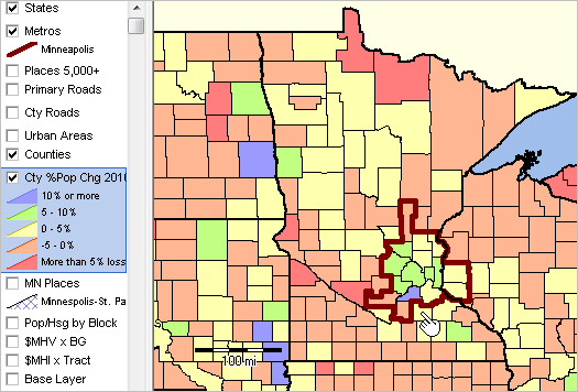
.. view developed using the CVGIS software.
.. illustrates use of the "us1_metros_minneapolis1.gis" GIS project.

Demographic Projections to 2060
Population and components of change data for the period 2010-2016 are included in the U.S. by county shapefile and part of the GIS project. Use the ProximityOne county level annual projections to 2060 to examine demographic characteristics and change into the future. The County 2060 projections are available by age single year of age by gender by race/origin by origin.

2. Patterns of Median Household Income by Neighborhood
The following graphic shows patterns of median household income by census tract for the Minneapolis metro area. This is the start-up view when using the GIS tools and data described below. The color patterns/intervals are shown in the highlighted layer in legend at left of map window. Use the GIS tools described below to develop thematic pattern maps for a range of data and criteria.

.. view developed using the CVGIS software.
.. illustrates use of the "us1_metros_minneapolis.gis" GIS project.

See more about census tracts; see tracts main page.

Several additional views follow, developed using this same GIS project. These views illustrate different levels of geographic granularity and patterns of different subject matter.

3. Median Housing Value by Block Group
See more about block groups; see block groups main page.

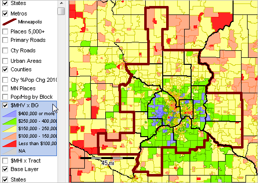
.. view developed using the CVGIS software.

4. Population/Housing Unit by Block
See more about census blocks; see census block main page.

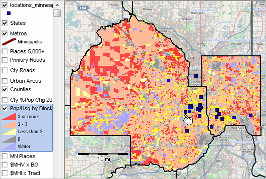
.. view developed using the CVGIS software.

5. Zoom-in to Minneapolis & St. Paul Cities
Minneapolis city and St. Paul city are shown as cross-hatched areas. This view uses a statewide by city layer/shapefile. A query is used to shows only these two cities for this view; any city(s) could be selected. The blue markers are Starbucks store locations further discussed below. See more about cities/places; see cities/places main page. Access data for any city using interactive table.

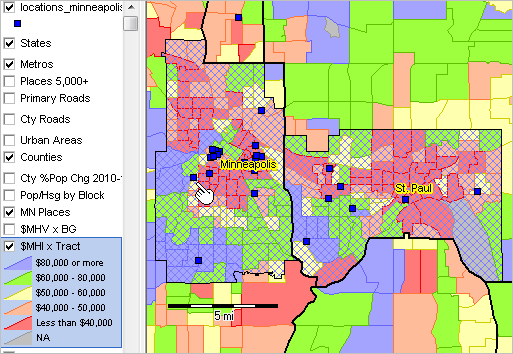
.. view developed using the CVGIS software.

6. Further Zoom-in Showing Street/Road Detail
See more about streets.

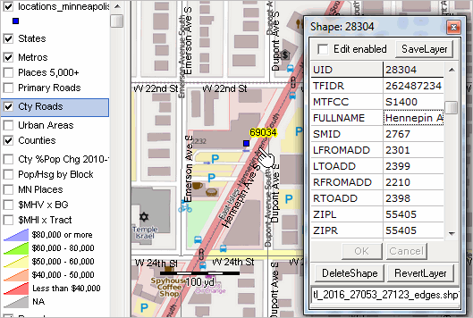
.. view developed using the CVGIS software.

Add Your Own Locations Data
This view shows locations of selected Starbucks stores in the Minneapolis City/County area. It is easy to see which locations are located in areas of higher/lower economic prosperity. The underlying layer shows patterns of median housing value by block group -- use your own selected subject matter and geography. Use any address or location data to create and add your own address/point shapefile. See that the "locations2" point shapefile appears at the top of the legend panel at left of map window. The identify tool is used to click on a store location (see pointer) and show a mini-profile. Use as many attributes as you like for your locations data. See more about creating location shapefiles (CLS). The CLS process enables you to automatically assign a census block code to each location/point.
7. Locations in Context of Small Area Demographic Patterns

.. same view as "2 cities" above.

Drill-down to the same store location highlighted in above views (by pointer)

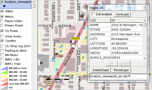
.. view developed using the CVGIS software.

Installing the GIS Software and Project/Datasets (requires Windows computer with Internet connection)
1. Install the ProximityOne CV XE GIS
... run the CV XE GIS installer
... requires UserID; take all defaults during installation
2. Download the Minneapolis Metro GIS project fileset
... requires UserID; unzip Minneapolis Metro GIS project files to local new folder c:\p1data
3. Open the c:\p1data\us1_metros_minneapolis.gis project
... after completing the above steps, click File>Open>Dialog
... open the file named c:\p1data\us1_metros_minneapolis.gis
... optionally use project file named c:\p1data\us1_metros_minneapolis1.gis
4. Done. The start-up view is shown above.

GIS Project Layers
Layer 1 -- LayerName: States - LayerFileName: cb_2016_us_state_500k.shp
1-1 STATEFP C, 2, 0
1-2 STATENS C, 8, 0
1-3 AFFGEOID C, 11, 0
1-4 GEOID C, 2, 0
1-5 STUSPS C, 2, 0
1-6 NAME C, 100, 0
1-7 LSAD C, 2, 0
1-8 ALAND N, 14, 0
1-9 AWATER N, 14, 0


Layer 2 -- LayerName: Primary Roads US -- LayerFileName: tl_2016_us_primaryroads.shp
2-1 LINEARID C, 22, 0
2-2 FULLNAME C, 100, 0
2-3 RTTYP C, 1, 0
2-4 MTFCC C, 5, 0


Layer 3 -- LayerName: places points US -- LayerFileName: places2015pts.shp
3-1 USPS C, 2, 0
3-2 GEOID C, 7, 0
3-3 ANSICODE C, 18, 0
3-4 NAME C, 60, 0
3-5 LSAD C, 2, 0
3-6 FUNCSTAT C, 2, 0
3-7 ALAND_SQMT C, 14, 0
3-8 AWATR_SQMT C, 14, 0
3-9 ALAND_SQMI N, 12, 3
3-10 AWATR_SQMI N, 12, 3
3-11 LAT N, 12, 6
3-12 LON N, 12, 6
3-13 STCTY C, 5, 0
3-14 CEN2010 N, 9, 0
3-15 BASE2010 N, 9, 0
3-16 POP2010 N, 9, 0
3-17 POP2011 N, 9, 0
3-18 POP2012 N, 9, 0
3-19 POP2013 N, 9, 0
3-20 POP2014 N, 9, 0
3-21 POP2015 N, 9, 0
3-22 POP1015 N, 9, 0
3-23 POP1015P N, 9, 2


Layer 4 -- LayerName: CBSAs US -- LayerFileName: cb_2016_us_cbsa_500k.shp
4-1 CSAFP C, 3, 0
4-2 CBSAFP C, 5, 0
4-3 AFFGEOID C, 14, 0
4-4 GEOID C, 5, 0
4-5 NAME C, 100, 0
4-6 LSAD C, 2, 0
4-7 ALAND N, 14, 0
4-8 AWATER N, 14, 0


Layer 5 -- LayerName: urban areas US -- LayerFileName: cb_2016_us_ua10_500k.shp
5-1 UACE10 C, 5, 0
5-2 AFFGEOID10 C, 14, 0
5-3 GEOID10 C, 5, 0
5-4 NAME10 C, 100, 0
5-5 LSAD10 C, 2, 0
5-6 UATYP10 C, 1, 0
5-7 ALAND10 N, 14, 0
5-8 AWATER10 N, 14, 0


Layer 6 -- LayerName: counties US -- LayerFileName: cb_2016_us_county_500k_pop2016.shp
6-1 STATEFP C, 2, 0
6-2 COUNTYFP C, 3, 0
6-3 COUNTYNS C, 8, 0
6-4 AFFGEOID C, 14, 0
6-5 GEOID C, 5, 0
6-6 NAME C, 100, 0
6-7 LSAD C, 2, 0
6-8 ALAND N, 14, 0
6-9 AWATER N, 14, 0
6-10 CSAFP C, 3, 0
6-11 CBSAFP C, 5, 0
6-12 METDIVFP C, 5, 0
6-13 INTPTLAT C, 11, 0
6-14 INTPTLON C, 12, 0
6-15 CEN2010 N, 9, 0
6-16 POP2010 N, 9, 0
6-17 POP2011 N, 9, 0
6-18 POP2012 N, 9, 0
6-19 POP2013 N, 9, 0
6-20 POP2014 N, 9, 0
6-21 POP2015 N, 9, 0
6-22 POP2016 N, 9, 0
6-23 CHG1015 N, 9, 0
6-24 CHG1015P N, 9, 1
6-25 CHG1016 N, 9, 0
6-26 CHG1016P N, 9, 1
6-27 NCHG2010 N, 9, 0
6-28 NCHG2011 N, 9, 0
6-29 NCHG2012 N, 9, 0
6-30 NCHG2013 N, 9, 0
6-31 NCHG2014 N, 9, 0
6-32 NCHG2015 N, 9, 0
6-33 NCHG2016 N, 9, 0
6-34 BIRTHS2010 N, 9, 0
6-35 BIRTHS2011 N, 9, 0
6-36 BIRTHS2012 N, 9, 0
6-37 BIRTHS2013 N, 9, 0
6-38 BIRTHS2014 N, 9, 0
6-39 BIRTHS2015 N, 9, 0
6-40 BIRTHS2016 N, 9, 0
6-41 DEATHS2010 N, 9, 0
6-42 DEATHS2011 N, 9, 0
6-43 DEATHS2012 N, 9, 0
6-44 DEATHS2013 N, 9, 0
6-45 DEATHS2014 N, 9, 0
6-46 DEATHS2015 N, 9, 0
6-47 DEATHS2016 N, 9, 0
6-48 NATINC2010 N, 9, 0
6-49 NATINC2011 N, 9, 0
6-50 NATINC2012 N, 9, 0
6-51 NATINC2013 N, 9, 0
6-52 NATINC2014 N, 9, 0
6-53 NATINC2015 N, 9, 0
6-54 NATINC2016 N, 9, 0
6-55 NATINC1016 N, 9, 0
6-56 INTMIG2010 N, 9, 0
6-57 INTMIG2011 N, 9, 0
6-58 INTMIG2012 N, 9, 0
6-59 INTMIG2013 N, 9, 0
6-60 INTMIG2014 N, 9, 0
6-61 INTMIG2015 N, 9, 0
6-62 INTMIG2016 N, 9, 0
6-63 DOMMIG2010 N, 9, 0
6-64 DOMMIG2011 N, 9, 0
6-65 DOMMIG2012 N, 9, 0
6-66 DOMMIG2013 N, 9, 0
6-67 DOMMIG2014 N, 9, 0
6-68 DOMMIG2015 N, 9, 0
6-69 DOMMIG2016 N, 9, 0
6-70 NETMIG2010 N, 9, 0
6-71 NETMIG2011 N, 9, 0
6-72 NETMIG2012 N, 9, 0
6-73 NETMIG2013 N, 9, 0
6-74 NETMIG2014 N, 9, 0
6-75 NETMIG2015 N, 9, 0
6-76 NETMIG2016 N, 9, 0
6-77 NETMIG1016 N, 9, 0
6-78 RES2010 N, 9, 0
6-79 RES2011 N, 9, 0
6-80 RES2012 N, 9, 0
6-81 RES2013 N, 9, 0
6-82 RES2014 N, 9, 0
6-83 RES2015 N, 9, 0


Layer 7 -- LayerName: counties2 US -- LayerFileName: cb_2016_us_county_500k_pop2016.shp
7-1 STATEFP C, 2, 0
7-2 COUNTYFP C, 3, 0
7-3 COUNTYNS C, 8, 0
7-4 AFFGEOID C, 14, 0
7-5 GEOID C, 5, 0
7-6 NAME C, 100, 0
7-7 LSAD C, 2, 0
7-8 ALAND N, 14, 0
7-9 AWATER N, 14, 0
7-10 CSAFP C, 3, 0
7-11 CBSAFP C, 5, 0
7-12 METDIVFP C, 5, 0
7-13 INTPTLAT C, 11, 0
7-14 INTPTLON C, 12, 0
7-15 CEN2010 N, 9, 0
7-16 POP2010 N, 9, 0
7-17 POP2011 N, 9, 0
7-18 POP2012 N, 9, 0
7-19 POP2013 N, 9, 0
7-20 POP2014 N, 9, 0
7-21 POP2015 N, 9, 0
7-22 POP2016 N, 9, 0
7-23 CHG1015 N, 9, 0
7-24 CHG1015P N, 9, 1
7-25 CHG1016 N, 9, 0
7-26 CHG1016P N, 9, 1
7-27 NCHG2010 N, 9, 0
7-28 NCHG2011 N, 9, 0
7-29 NCHG2012 N, 9, 0
7-30 NCHG2013 N, 9, 0
7-31 NCHG2014 N, 9, 0
7-32 NCHG2015 N, 9, 0
7-33 NCHG2016 N, 9, 0
7-34 BIRTHS2010 N, 9, 0
7-35 BIRTHS2011 N, 9, 0
7-36 BIRTHS2012 N, 9, 0
7-37 BIRTHS2013 N, 9, 0
7-38 BIRTHS2014 N, 9, 0
7-39 BIRTHS2015 N, 9, 0
7-40 BIRTHS2016 N, 9, 0
7-41 DEATHS2010 N, 9, 0
7-42 DEATHS2011 N, 9, 0
7-43 DEATHS2012 N, 9, 0
7-44 DEATHS2013 N, 9, 0
7-45 DEATHS2014 N, 9, 0
7-46 DEATHS2015 N, 9, 0
7-47 DEATHS2016 N, 9, 0
7-48 NATINC2010 N, 9, 0
7-49 NATINC2011 N, 9, 0
7-50 NATINC2012 N, 9, 0
7-51 NATINC2013 N, 9, 0
7-52 NATINC2014 N, 9, 0
7-53 NATINC2015 N, 9, 0
7-54 NATINC2016 N, 9, 0
7-55 NATINC1016 N, 9, 0
7-56 INTMIG2010 N, 9, 0
7-57 INTMIG2011 N, 9, 0
7-58 INTMIG2012 N, 9, 0
7-59 INTMIG2013 N, 9, 0
7-60 INTMIG2014 N, 9, 0
7-61 INTMIG2015 N, 9, 0
7-62 INTMIG2016 N, 9, 0
7-63 DOMMIG2010 N, 9, 0
7-64 DOMMIG2011 N, 9, 0
7-65 DOMMIG2012 N, 9, 0
7-66 DOMMIG2013 N, 9, 0
7-67 DOMMIG2014 N, 9, 0
7-68 DOMMIG2015 N, 9, 0
7-69 DOMMIG2016 N, 9, 0
7-70 NETMIG2010 N, 9, 0
7-71 NETMIG2011 N, 9, 0
7-72 NETMIG2012 N, 9, 0
7-73 NETMIG2013 N, 9, 0
7-74 NETMIG2014 N, 9, 0
7-75 NETMIG2015 N, 9, 0
7-76 NETMIG2016 N, 9, 0
7-77 NETMIG1016 N, 9, 0
7-78 RES2010 N, 9, 0
7-79 RES2011 N, 9, 0
7-80 RES2012 N, 9, 0
7-81 RES2013 N, 9, 0
7-82 RES2014 N, 9, 0
7-83 RES2015 N, 9, 0


Layer 8 -- LayerName: places statewide -- LayerFileName: cb_2016_48_place_500k.shp
8-1 STATEFP C, 2, 0
8-2 PLACEFP C, 5, 0
8-3 PLACENS C, 8, 0
8-4 AFFGEOID C, 16, 0
8-5 GEOID C, 7, 0
8-6 NAME C, 100, 0
8-7 LSAD C, 2, 0
8-8 ALAND N, 14, 0
8-9 AWATER N, 14, 0


Layer 9 -- LayerName: roads metro -- LayerFileName: tl_2016_26420_edges_roads.shp
9-1 STATEFP C, 2, 0
9-2 COUNTYFP C, 3, 0
9-3 TLID N, 10, 0
9-4 TFIDL N, 10, 0
9-5 TFIDR N, 10, 0
9-6 MTFCC C, 5, 0
9-7 FULLNAME C, 50, 0
9-8 SMID C, 22, 0
9-9 LFROMADD C, 12, 0
9-10 LTOADD C, 12, 0
9-11 RFROMADD C, 12, 0
9-12 RTOADD C, 12, 0
9-13 ZIPL C, 5, 0
9-14 ZIPR C, 5, 0
9-15 FEATCAT C, 1, 0
9-16 HYDROFLG C, 1, 0
9-17 RAILFLG C, 1, 0
9-18 ROADFLG C, 1, 0
9-19 OLFFLG C, 1, 0
9-20 PASSFLG C, 1, 0
9-21 DIVROAD C, 1, 0
9-22 EXTTYP C, 1, 0
9-23 TTYP C, 1, 0
9-24 DECKEDROAD C, 1, 0
9-25 ARTPATH C, 1, 0
9-26 PERSIST C, 1, 0
9-27 GCSEFLG C, 1, 0
9-28 OFFSETL C, 1, 0
9-29 OFFSETR C, 1, 0
9-30 TNIDF N, 10, 0
9-31 TNIDT N, 10, 0


Layer 10 -- LayerName: blocks metro -- LayerFileName: tabblock2010_26420_pophu.shp
10-1 STATEFP10 C, 2, 0
10-2 COUNTYFP10 C, 3, 0
10-3 TRACTCE10 C, 6, 0
10-4 BLOCKCE C, 4, 0
10-5 BLOCKID10 C, 15, 0
10-6 PARTFLG C, 1, 0
10-7 HOUSING10 N, 9, 0
10-8 POP10 N, 9, 0
10-9 UR10 C, 1, 0
10-10 UACE10 C, 5, 0
10-11 ALAND N, 14, 0
10-12 AWATER N, 14, 0
10-13 INTPTLAT C, 11, 0
10-14 INTPTLON C, 12, 0


Layer 11 -- LayerName: block groups statewide -- LayerFileName: cb_2016_48_bg_500k.shp
11-1 STATEFP C, 2, 0
11-2 COUNTYFP C, 3, 0
11-3 TRACTCE C, 6, 0
11-4 BLKGRPCE C, 1, 0
11-5 AFFGEOID C, 21, 0
11-6 GEOID C, 12, 0
11-7 NAME C, 100, 0
11-8 LSAD C, 2, 0
11-9 ALAND N, 14, 0
11-10 AWATER N, 14, 0
11-11 B02001_001 N, 12, 0
11-12 B02001_002 N, 12, 0
11-13 B02001_003 N, 12, 0
11-14 B02001_004 N, 12, 0
11-15 B02001_005 N, 12, 0
11-16 B02001_006 N, 12, 0
11-17 B02001_007 N, 12, 0
11-18 B02001_008 N, 12, 0
11-19 B03002_012 N, 12, 0
11-20 B19013_001 N, 12, 0
11-21 B25077_001 N, 12, 0
11-22 B11001_001 N, 12, 0
11-23 B11001_002 N, 12, 0
11-24 B11001_003 N, 12, 0
11-25 B11001_004 N, 12, 0
11-26 B11001_005 N, 12, 0
11-27 B11001_006 N, 12, 0
11-28 B11001_007 N, 12, 0
11-29 B11001_008 N, 12, 0
11-30 B11001_009 N, 12, 0
11-31 B15003_001 N, 12, 0
11-32 B15003_002 N, 12, 0
11-33 B15003_003 N, 12, 0
11-34 B15003_004 N, 12, 0
11-35 B15003_005 N, 12, 0
11-36 B15003_006 N, 12, 0
11-37 B15003_007 N, 12, 0
11-38 B15003_008 N, 12, 0
11-39 B15003_009 N, 12, 0
11-40 B15003_010 N, 12, 0
11-41 B15003_011 N, 12, 0
11-42 B15003_012 N, 12, 0
11-43 B15003_013 N, 12, 0
11-44 B15003_014 N, 12, 0
11-45 B15003_015 N, 12, 0
11-46 B15003_016 N, 12, 0
11-47 B15003_017 N, 12, 0
11-48 B15003_018 N, 12, 0
11-49 B15003_019 N, 12, 0
11-50 B15003_020 N, 12, 0
11-51 B15003_021 N, 12, 0
11-52 B15003_022 N, 12, 0
11-53 B15003_023 N, 12, 0
11-54 B15003_024 N, 12, 0
11-55 B15003_025 N, 12, 0


Layer 12 -- LayerName: tracts statewide -- LayerFileName: cb_2016_48_tract_500k.shp
12-1 STATEFP C, 2, 0
12-2 COUNTYFP C, 3, 0
12-3 TRACTCE C, 6, 0
12-4 AFFGEOID C, 20, 0
12-5 GEOID C, 11, 0
12-6 NAME C, 100, 0
12-7 LSAD C, 2, 0
12-8 ALAND N, 14, 0
12-9 AWATER N, 14, 0
12-10 E062 N, 9, 0


Layer 13 -- LayerName: US by state -- LayerFileName: cb_2015_us_state_500k.shp
13-1 STATEFP C, 2, 0
13-2 STATENS C, 8, 0
13-3 GEOID C, 2, 0
13-4 STUSPS C, 2, 0
13-5 NAME C, 100, 0
13-6 LSAD C, 2, 0
13-7 ALAND N, 14, 0
13-8 AWATER N, 14, 0
13-9 CEN2010 N, 9, 0
13-10 POP2010 N, 9, 0
13-11 POP2011 N, 9, 0
13-12 POP2012 N, 9, 0
13-13 POP2013 N, 9, 0
13-14 POP2014 N, 9, 0
13-15 POP2015 N, 9, 0


Block Group Layer Attributes
Data are from 2015 ACS 5-year estimates unless otherwise noted.
B02001_001E >>Total:
B02001_002E >>White alone
B02001_003E >>Black or African American alone
B02001_004E >>American Indian and Alaska Native alone
B02001_005E >>Asian alone
B02001_006E >>Native Hawaiian and Other Pacific Islander alone
B02001_007E >>Some other race alone
B02001_008E >>Two or more races:
B03002_012E Hispanic or Latino
B19013_001E Median household income
B25077_001E Median value (dollars)
B11001_001E >>Total:
B11001_002E >>Family households:
B11001_003E >>Married-couple family
B11001_004E >>Other family:
B11001_005E >>Male householder, no wife present
B11001_006E >>Female householder, no husband present
B11001_007E >>Nonfamily households:
B11001_008E >>Householder living alone
B11001_009E >>Householder not living alone
B15003_001E >>Total:Educational Attainment for the Population 25 Years and Over
B15003_002E >>No schooling completed
B15003_003E >>Nursery schoolE
B15003_004E >>KindergartenE
B15003_005E >>1st gradeE
B15003_006E >>2nd gradeE
B15003_007E >>3rd gradeE
B15003_008E >>4th gradeE
B15003_009E >>5th gradeE
B15003_010E >>6th gradeE
B15003_011E >>7th gradeE
B15003_012E >>8th gradeE
B15003_013E >>9th gradeE
B15003_014E >>10th gradeE
B15003_015E >>11th gradeE
B15003_016E >>12th grade, no diplomaE
B15003_017E >>Regular high school diplomaE
B15003_018E >>GED or alternative credentialE
B15003_019E >>Some college, less than 1 yearE
B15003_020E >>Some college, 1 or more years, no degreeE
B15003_021E >>Associate's degreeE
B15003_022E >>Bachelor's degreeE
B15003_023E >>Master's degreeE
B15003_024E >>Professional school degreeE
B15003_025E >>Doctorate degreeE

Support Using these Resources
Learn more about demographic economic data and related analytical tools. Join us in a Data Analytics Lab session. There is no fee for these Web sessions. Each informal session is focused on a specific topic. The open structure also provides for Q&A and discussion of application issues of interest to participants.

ProximityOne User Group
Join the ProximityOne User Group to keep up-to-date with new developments relating to geographic-demographic-economic decision-making information resources. Receive updates and access to tools and resources available only to members. Use this form to join the User Group.

Additional Information
ProximityOne develops geodemographic-economic data and analytical tools and helps organizations knit together and use diverse data in a decision-making and analytical framework. We develop custom demographic/economic estimates and projections, develop geographic and geocoded address files, and assist with impact and geospatial analyses. Wide-ranging organizations use our tools (software, data, methodologies) to analyze their own data integrated with other data. Follow ProximityOne on Twitter at www.twitter.com/proximityone. Contact us (888-364-7656) with questions about data covered in this section or to discuss custom estimates, projections or analyses for your areas of interest.


Copyright © . ProximityOne. All Rights Reserved.
Sitemap | Contact Us | News