
|
|
|
-- tools to access data via Internet for analytical/reference use on your computer -- integrating geostatistical data for visual & predictive data analytics Possibly the most well known APIs (Application Programming Interface) are the Google APIs. Among these, the Google Maps API, or its use, might be the most familiar. See about integrating political/statistical geography and Google Maps API. This section reviews different types of APIs. Data Analytics and APIs API technology/tools play an important role in accessing and integrating geographic, demographic and economic data. APIs offer two types of benefits. For Web-based applications, APIs provide the ability for on-the-fly access to selected demographic-economic buried in otherwise large datasets that typically otherwise involve downloading and preprocessing. A second important benefit/use is to extract data from those same datasets, reconfigure the structure of the data retrieved by API and create a new dataset structure that lends itself to analytical applications. ProximityOne Data Analytics sessions review purpose, scope, strengths, advantages & limitations of APIs described in this section. Topics of this section include: • Federal Geographic-Demographic-Economic Data Access Using APIs • REST APIs • Federal Communications Commission • Bureau of the Census ... much more than Census • Bureau of Economic Analysis • Bureau of Labor Statistics • Data Access & Analytics Applications There are hundreds more APIs available from Federal agencies and wide-ranging sources. Using APis and GIS: Visualizing Patterns; Geospatial Analysis The following graphic has been developed first using API tools to create the underlying datasets. While the source data used in this application could have been downloaded and processed in legacy manner, the API tools provide on-the-fly development of the data in a structure required by the GIS software. These data are then integrated into shapefiles for use with the GIS software. Once the datasets are developed, they can be used in a myriad of application, GIS and otherwise. Patterns of Male Hispanic Population Age 5 Years by ZIP Code -- Houston, TX Area 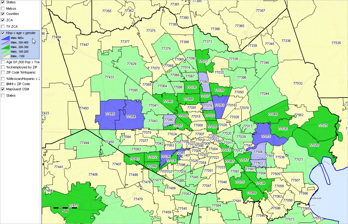 • Click graphic for larger view with ZIP Code labels and more detail. • The graphic shows patterns of the Male Hispanic population 5 years of age as of Census 2010. • The view illustrates how single year of age by gender by race/origin can be visually analyzed. • See more about these data and single year of age demographics Federal Geographic-Demographic-Economic Data Access Using APIs ... Federal Geographic-Demographic-Economic Data Access Using APIs 1. REST APIs ... Geographic, demographic, economic data access resources ... In operation by selected Federal statistical and other agencies reviewed below 2. Federal Communications Commission • FCC -- latitude-longitude to census block code 3. Bureau of the Census • About the Census API • Census API Data Discovery 3.1. Illustrative examples Click the link and the JSON output returned is displayed. Examine the structure of the URL. Modify the URL and • 2015 Planning Database; Census 2010 total population for every block group in Harris County, TX • 2015 Planning Database; Census 2010 total population for every census tract in Texas .. new to Census API access 8/15 .. more about the 2015 Planning Database • ACS 2013 ACS 2013 1-year estimates Demographic Profile; ed attainment; Houston MSA (26420) • ACS 2013 ACS 2013 1-year estimates Demographic Profile; total pop; all metros • ACS 2013 5-year estimates Demographic Profile .. selected items; Santa Clara County (085) CA (06) tract 507001 • ACS 2012 5-year estimates Demographic Profile .. selected items; Santa Clara County (085) CA (06) tract 507001 • 1990 Census -- SF3 Block Group; block group 1 in tract 0101 Maricopa County, AZ • Census 2000 -- SF3 Block Group; block group 1 in tract 010100 Maricopa County, AZ • Census 2010 -- SF1 Block Group; block group 1 in tract 010101 (split) Maricopa County, AZ • 2014 County population estimates .. total population by gender by race/ethnicity 7/1/2014 -- Maricopa County, AZ • School District Finances 2012 -- expenditures, total; School Districts coded as located in Maricopa County, AZ • County Business Patterns 2013 .. employment & establishments in the Accommodation and Food Services sector -- Maricopa County, AZ 3.2. Washington, DC/District of Columbia examples • One subject matter item per API call: - Census 2000 SF1 total population - Census 2010 SF1 total population - Census 2000 SF1 White alone population - Census 2010 SF1 White alone population - Census 2000 SF1 Black alone population - Census 2010 SF1 Black alone population - Census 2000 SF1 Asian alone population - Census 2010 SF1 Asian alone population • Four subject matter items per API call: - Census 2000 SF1 Total, White, Black, Asian population - Census 2010 SF1 Total, White, Black, Asian population
4. Bureau of Economic Analysis • BEA API User Guide Regional Datasets; county, metro & higher level geography • Regional Data Items List • Metro GDP Dallas Metro, 2010 & 2012 - more about Metro GDP • County Per Capita Personal Income -- 2010 all counties - more about REIS 5. Bureau of Labor Statistics All BLS API calls use a series ID ... about BLS Series IDs 5.1. Quarterly Establishments, Employment & Earnings (QCEW; ES-202) more about State and County Employment and Wages from Quarterly Census of Employment and Wages Survey Overview The following is a sample format description of the Quarterly Census of Employment and Wages series identifier: Example of Series ID: ENU040131050A0115 (17 characters)
To structure series IDs, access any of the following for a list of codes and their corresponding titles: • Area Codes • Data Type Codes • Size Codes • Ownership Codes • Industry Codes Examples: Maricopa County, AZ, Quarterly, Total establishments, all industries -- Series ID ENU04013-2-05-10 Maricopa County, AZ, Quarterly, Total employment, all industries -- a monthly item within quarter -- Series ID ENU04013-1-05-10 Maricopa County, AZ, Quartery, Total wages, all industries -- Series ID ENU04013-3-05-10 Maricopa County, AZ, Average annual wages, all industries -- Series ID ENU04013-5-05-10 Maricopa County, AZ, Quarterly, Total establishments, Real Estate: NAICS 531 -- Series ID ENU04013-2-05-531 -- About the NAICS 531 Industry 5.2. Local Area Unemployment Statistics Statistical Program Overview The following is a sample format description of the Local Area Unemployment Statistics' series identifier: Example of Series ID: LAUCN281070000000003 (20 characters)
To structure series IDs, access any of the following for a list of codes and their corresponding titles: • Area Type Code • Area Codes • Measure Codes Examples Houston MSA unemployment rate (03) -- Series ID LA-MT-4826420000000-03 5.2.1. Kansas City, MO-KS MSA Employment (05) -- Series ID LAUMT292814000000005 5.2.2. Jackson County, MO Employment (05) -- Series ID LAUCN290950000000005 5.2.3. Kansas City city, MO employment (05) -- Series ID LAUCT293800000000005 Access employment data easily for any county. Replace the SSCCC characters in the following URL with state-county FIPS code (SSCCC) for any county and submit in browser. http://api.bls.gov/publicAPI/v1/timeseries/data/LAUCNSSCCC0000000005 Comparing LAUS estimates (5.2.1 - 5.2.3. above) to ACS 2013 1-year estimates (below). • Census -- ACS 2013 1 yr DP; employment attributes; KC metro (28140) 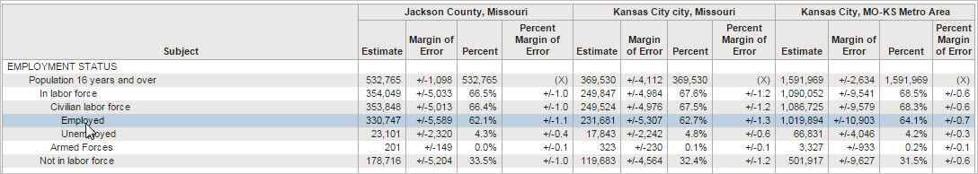 Click graphic for larger view. 5.3. Geographic Profile Geographic Profile Overview The following is a sample format description of the Geographic Profile series identifier: Example of Series ID: GPU00200000R0328 (16 characters)
To structure series IDs, access any of the following for a list of codes and their corresponding titles: • State Codes • Area Codes • Labor Force Codes • Character Codes 6. APIs & Coding: Programming Code, Scripts & Components ... illustrative code used to build dataset for interactive table at Schools ... "how to" -- review of code used to link API calls in 1.1. and 1.2 above for all schools in a state. ... attaching census block code and census tract demographics to school location ... used to develop school point shapefile & pattern analysis: CA Schools application 7. Using the Census API resource ... applications including accessing ACS 2013 data ... related derived ACS 2013 for 2013 Metros interactive table ... structuring and using a basic Census API call -- examples that you can immediately apply 8. Using Windows-based Delphi programming methods to manage API calls ... organizing downloaded data for subsequent use 9. Using the Demographic-Economic Data Extraction (DEDE) API resource ... develop Census 2000, Census 2010 & American Community Survey subject matter by block group dBase files ... related data extraction & data file development & use 10. Geocoding Address Data Using the API Geocoder ... assigning geocodes (block level) to addresses & assigning subject matter items to coded address records ... creating an address point shapefile and using the shapefile in a GIS application ... performing an address lookup; determine geocodes -- examples that you can immediately apply 11. Using APIGateway ... develop integrated data profiles (multi-sourced demographic-economic data) ... access/download Census 2010 Summary File 1 block level data 12. Using GeoGateway ... access/download Census TIGER/Line shapefiles 13. Examining characteristics of market and study areas using Site Analysis API ... access all Census 2000 SF3, Census 2010 SF1, ACS 2010-2012 block group data Support Using these Resources Learn more about demographic economic data and related analytical tools. Join us in a Data Analytics Lab session. Each informal session is focused on a specific topic. The open structure also provides for Q&A and discussion of application issues of interest to participants. ProximityOne User Group Join the ProximityOne User Group to keep up-to-date with new developments relating to geographic-demographic-economic decision-making information resources. Receive updates and access to tools and resources available only to members. Use this form to join the User Group. Additional Information ProximityOne develops geodemographic-economic data and analytical tools and helps organizations knit together and use diverse data in a decision-making and analytical framework. We develop custom demographic/economic estimates and projections, develop geographic and geocoded address files, and assist with impact and geospatial analyses. Wide-ranging organizations use our tools (software, data, methodologies) to analyze their own data integrated with other data. Follow ProximityOne on Twitter at www.twitter.com/proximityone. Contact us (888-364-7656) with questions about data covered in this section or to discuss custom estimates, projections or analyses for your areas of interest. |
|
|