
|
|
|
Geospatial Analytics VDA Web GIS Open VDA Web GIS VDA Desktop GIS DEDE Data Access Demographic Analytics |
.. being ready for 2025, 2030 and beyond .. managing sustainability .. enabling research and innovation .. implementing innovative learning experiences Get started today Install or update VDA Desktop GIS on your Windows computer: .. run installer .. userid required to run installer. Register for userid here. .. enter required info, check Requesting VDA Desktop GIS Installer ID, click Submit .. there is no fee; you will receive return email with userid E-mail us or call (888-364-7656) with questions/help. Main Menu/Topics What you can go with VDA Desktop GIS -- Gallery Introduction Support Start-up & Levels News & Updates User Interface & Operation Data Resources Illustrative Applications US1 GIS Project .. the start-up project Terms of Use FAQ - Frequently Asked Questions A tool for journalists, policy-makers, researchers, learners, analysts .. intuitive with nominal learning time. .. yet powerful enough to meet demanding needs of GIS professionals. Patterns of How & Why County Population is Changing .. VDAD Start-up View 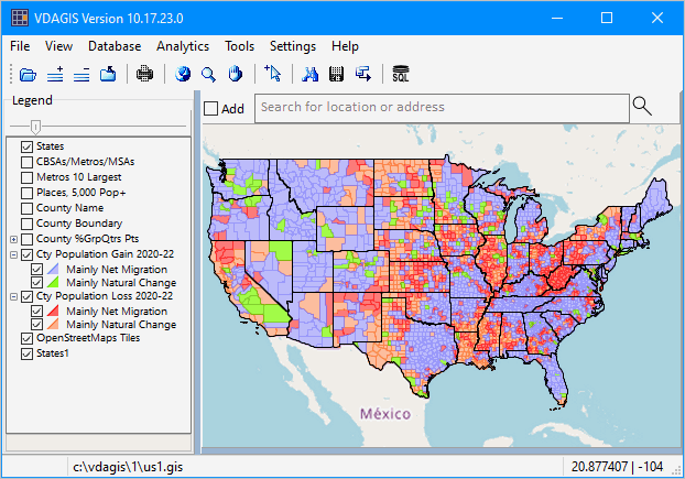 Gallery .. Make Maps Like These ... selected examples .. goto top Use the Base Server project to create views and perform operations like these. Congressional Communities in context of Congressional District CA 47 
Congressional District Percent Population Change 2020-2022 .. select 2020 items and ACS2022 items in this layer/shapefile .. see related views 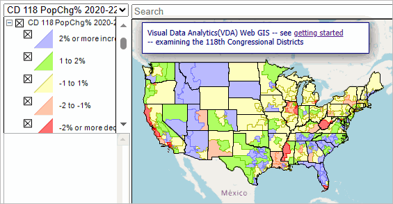
Patterns of %Group Quarters Population by County Markers (US1 Project) 4 Texas counties have more than 25% population in group quarters. These data matter in development of population projections, among other applications. The graphic below shows how to find/view/analyze relevant geographies using the VDA GIS tools. .. larger triangles show these counties, the table shows data in tabular form. 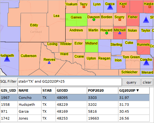
Census Tract %Population Age 65+ in Houston, TX city 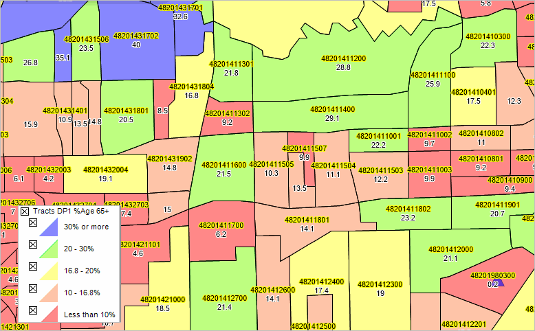
Patterns of Economic Prosperity by Census Tract; Phoenix Area .. with census tract codes 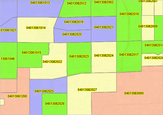
Attributes of a Congressional Community (CC); Phoenix Area .. click CC then click HTML button lower left to view profile CC profile (xls) 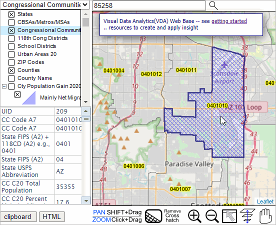
Using Table/Grid Feature; 2020 Urban Areas in Texas Ranked on 2020 Population .. Urban Areas the active layer; click Table view; use query"select NAME20, ST, POP where st='TX'"; sort descending order on POP 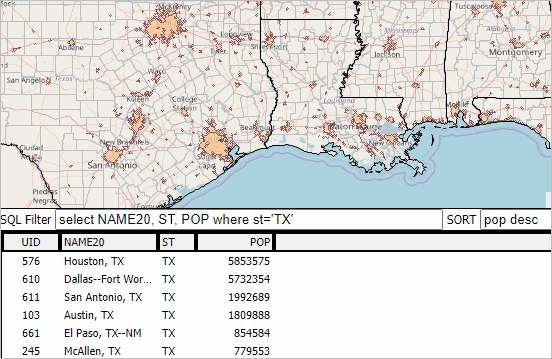
State Quarterly GDP .. States the active layer; click Table view; 
Introduction to VDA Desktop GIS .. companion to Visual Data Analytics (VDA) Web GIS .. goto top .. develop your GIS projects with VDA Desktop; use locally and/or post to VDA Web GIS for use by your organization/stakeholders VDA Desktop and VDA Web GIS have been developed, and are maintained/supported, by ProximityOne/Alexandria, VA USA and Tsukasa Consulting/Osaka, Japan. Support Support is offered via Web pages, telephone, e-mail and web sessions. Learn more about demographic economic data and related analytical tools. One hour Web Sessions are offered on Tuesday, Wednesday & Thursday. There is no fee for the Web sessions. Each informal session is focused on a specific topic. The open structure also provides for Q&A and discussion of application issues of interest to participants. Start-up & Levels .. goto top When VDA Desktop GIS (VDAD) is installed and then started, VDAD will be operating as Level 1. These features, as with all items in this document, are subject to change without notice. There are 3 VDAD levels of operation. Level 1 - install VDAD Level 1 is a no fee resource. Enables: • File>Login (sets features available; selection of other Level) • Open GIS project. • Search for location/address • Find shape • Selected object profile • Use of legend and layer editor. • Map navigation features • Table/Grid • Settings Level 2 - VDAW signup with Level 2 then with • Level 2 with File>Login Level 2 is a fee-based resource .. E-mail us or call (888-364-7656) to inquire for details. Includes Level 1 features plus: • adding layers to Base Server Project • opening Base Server Project • access to Database features • open many server projects • adding layers to Base Server Project • saving project Level 3 - VDAW signup with Level 3 then with • Level 3 with File>Login Level 3 is a fee-based resource .. E-mail us or call (888-364-7656) to inquire for details. Includes Level 2 features plus: Enables Level 2 plus: • Analytics>GeoSelect/SiteAnalysis • Batch geocoding • Tools features User Interface & Operation .. goto top This subsection summarizes the basics of the User Interface. Main Menu File Login Open ... Open Server Project View Database Analytics Tools Settings Help Toolbar Open Folder Add Layer Remove Layer Close all layers Zoom to US 48 Extent Enable mouse as Zoom tool Enable mouse as Select tool Enable mouse as Pan/Drag tool Find Shape Coordinate System Toggle Table/Grid Legend Panel - shows layers in active project Search Bar - key in address/location and press enter to find Map Window - shows map based on layers in legend panel checked on Status Bar -- shows status of selected attributes News & Updates .. goto top 10.24.23 .. Version 10.24.23 released
• new installer released.
• two U.S. by county layers added. - point layer -- patterns of percent group quarters population - polygon layer -- initial use as boundary 10.17.23 .. Version 10.17.23 released
• new software version released.
• Select Fields feature added to Table/Grid operation. Data Resources .. goto top Import/integrate these data resources into your VDAD GIS projects. • TIGER Shapefiles (pdf) .. see more about TIGER digital map database • Census 2020 Demographics • ACS Richer Demographic Economic Data Applications .. goto top App 01 -- Mapping Tracts & ZIP Codes .. goto top Consider an application where you want to view a few census tracts in context of ZIP Code areas. Steps below illustrate use of the VDA Desktop (VDAD) Start VDAD .. then click File>Open Server Project and open the Base Project After the map view shows, enter a ZIP code, location or address in the Search bar and press enter. .. to illustrate, enter 85258 (a ZIP code in Scottsdale, AZ) and press enter A zoom-in then shows a blue triangle marker at the location. .. in the legend panel at left, click checkbox on for each of these layers: - ZIP Codes Label (displays ZIP Code area labels/codes in map) - ZIP Codes (displays ZIP Code area red boundaries in map) - Tracts Label (displays Tract code and black tract boundaries in map) .. navigate to preferred view (e.g., pan or zoom in/out) .. use a screen capture tool to capture view meeting application objective Pointer in graphic shows ZIP code 85258 with several tracts intersecting the 85258 ZIP code red boundary. End of App 01. App 02 -- Patterns of Percent Group Quarters by Congressional Community .. goto top Consider an application where you want to view/analyze population in households and group quarters population by Congressional Community (CCs). A more focused objective is to locate and view those CCs in California that have a group quarters percent of 30% or more. Steps below illustrate use of the VDA Desktop (VDAD) Start VDAD .. then click File>Open Server Project and open the Base Project After the map view shows, click the name of the "Cong Communities Diversity" layer in the legend panel. .. name highlights blue .. while the name of this layer says "Diversity" that is because the layer is set to display diversity patterns. .. the underlying shapefile contains all Census 2020 DP1 items. Next, click the SQL/Table/Grid button .. rightmost button on the top menubar The view refreshes with a view similar to the graphic shown below. Click graphic for larger view The table/grid below the map shows a row for each shape/object in the active layer shapefile. .. the columns show the field names for each field in the active layer shapefile.  In this application, the focus is on selected fields: CCN20 -- Congressional Communities (CCs) Geocode D112TPOP -- total population D113RPINHH -- persons living in households D125GQQTR -- persons living in group quarters D126GQI -- persons living in institutional group quarters D129GQNI -- persons living in non-institutional group quarters Next, set an SQL filter to find those CCs in California that have a group quarters percent of 30% or more: select ccn20,100*D125GQQTR/D112TPOP where ccn20 like '06%' and 100*D125GQQTR/D112TPOP>30 .. copy & paste the above query into the SQL Filter edit box. .. click the Query button to locate/show the CCs and relevant items. This query "says" to select/show the two items: ccn20 -- the CC name/geoid 100*D125GQQTR/D112TPOP -- the realtime computed group quarters population as a percent of total population where the CC: is in California (ccn20 like '06%') and the %GC is greater than 30 (100*D125GQQTR/D112TPOP>30) Results of query (click graphic for larger view):  Results of query shown in mapview (click graphic for larger view):  End of App 02. US1 GIS Project .. goto top The US1 GIS Project is installed when the VDA Desktop installer is run. The start-up view is shown below. The start-up view shows patterns of percent population change by county from 2010 to 2020. The 5th layer (County Pop10-Pop20 %Change) is checked on in the Legend Panel. .. this results in that layer being shown in the Map Window. Color patterns and associated percent change ranges are show in the intervals. The Base Project includes these layers, as shown in the legend panel in the above graphic. Things you should know about the Base Project. .. the legend panel shows layers by name. .. all layers, except the Base Layer, are - in shapefile structure and stored locally on the installed computer. - U.S. national scope layers. - comprised of fields listed in the scroll section below. .. thematic pattern layers are set with a transarency of 70% which can be adjusted. -- enables "seeing through" color patterns to view roads/topology/names ahown in the base layer. Layer 1 -- LayerName: States -- States .. examine characteristics of states
Layer 2 -- LayerName: Metros/CBSAs -- Metros/Core-Based Statistical Areas .. examine characteristics metropolitan areas
Layer 3 -- Congressional Districts -- Congressional Districts .. examine characteristics congressional districts
Layer 4 -- Counties -- Counties
Layer 5 -- County Pop10-Pop20 %Change -- Counties .. examine patterns of percent population change .. 2010 - 2020 .. same fields as in Layer 4 Layer 6 -- Tract Code -- Census Tracts
Layer 7 -- Tract $MHI -- Census Tracts .. examine patterns of $MHI .. median household income .. same fields as in Layer 6 Layer 8 -- Base Layer -- States .. a global Web-based topographic layer Layer 9 -- States1 -- States .. used a U.S. States base layer Terms of Use .. goto top There is no warranty, express or implied, for any aspect of use of the VDA Desktop GIS installer, software or data. The user is solely responsible for any use made of the VDA Desktop GIS installer, software or data or use of resulting output. The user agrees not to distribute the VDA Desktop GIS installer, software or data. The user agrees that data provided with VDA Desktop GIS installer is for exclusive use with VDA Desktop GIS software. All features and items in this document are subject to change without notice. |
|
|