
|
|
|
-- ready-to-use GIS projects for each Metropolitan Area The MetroGIS program provides access to ready-to-use GIS projects for each Metropolitan Area -- Core-Based Statistical Area (CBSA). Metros, CBSAs, are 933 areas comprised of one or more contiguous counties and defined by OMB in accordance with a set of standards. CBSAs are home to more than 93% of the U.S. population. See more about CBSAs/metros. Use the S&O Metro Geographic Information System (GIS) projects on your Windows computer with CV XE GIS software to visually and geospatially analyze geographic, demographic, economic, business characteristics, patterns and trends. Add your own data. Flexibly modify the views and data. This section reviews the scope and structure of the MetroGIS projects. See pricing & getting started details below. .. statistical mapping & visual data analysis ... Geographic Information Systems (GIS) provide flexible and powerful capabilities to combine maps with data. In our increasingly data rich environment, we often experience "drowning in data." GIS tools can help harness disparate and voluminous data and assist with data linkage. This section provides links to other sections that provide information on ready-to-use, "production" GIS projects and datasets that you can use. Your Benefits • Visual data analytics; powerful resource for collaborative planning & research. • Ready-to-use integrated Census American Community Survey (ACS) data. .. integrated data from Census population estimates & components of change. • Data integrated in GIS also available in Web-based interactive tables; no cost. .. example: tract level geography and data included in GIS project for state intersecting with metro. .. same tract level data available, for U.S., in these four interactive tables. • Automatically integrate Census 2020 data as released (starting early 2021). • The geographic-demographic-economic content/structure in the projects are unique. • Develop views, perform geospatial analysis with much faster speed than Web-based applications. • Use the geosptial power and features not available with Web-based applications. • Use the unique set of geography & subject matter. .. drill down to the census tract, ZIP code and block group geographic levels. .. city/place legally defined areas as og January 2018 (updated annually). • Nominal learning curve; GIS experience not required. .. GIS professional find it a powerful resource; integrating with related tools. What you Can Do • Choose the geography and subject matter to tell a story or gain insights into a topic. • examine patterns of economic prosperity by neighborhood acrss the metro. • View the metro lay of the land using different geography or subject matter. • Create reference or thematic pattern view. .. view one city in context of the metro or selected cities based on a criteria. .. view K-12 schools by type of school in context of streets, neighborhoods. .. zoom to the desired level -- to the street intersection level. .. place queries on layers to view of geographies meeting a criteria you specify. .. label geography with attributes that you select. .. for thematic maps, select the subject matter/intervals/patterns that you want. • Add your layers -- geography and data. • The desktop GIS assures that your data is secure; not shared on a network. Illustrative MetroGIS projects .. the MetroGIS projects include the same set of GIS layers, adapted to that metro. The graphics shown below illustrate the start-up views for the Chicago and Miami metros. Chicago-Naperville-Elgin, IL-IN-WI MSA .. start-up view of the Chicago MetroGIS .. patterns of economic prosperity by neighborhood .. median household income by census tract .. click graphic for larger view showing legend; expand browser window .. zoom-in to Chicago city; showing block groups rather than census tracts 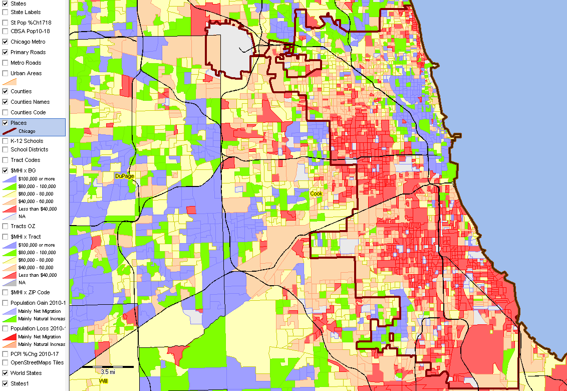 -- view created using CV XE GIS and associated MetroGIS Project Additional views and analyses; expand browser window to full screen for best view ... • Patterns of net migration by county .. larger view Houston-The Woodlands-Sugar Land, TX MSA .. start-up view of the Houston MetroGIS .. patterns of economic prosperity by neighborhood .. median household income by census tract .. click graphic for larger view showing legend; expand browser window .. zoom-in to Houston city; showing city as cross-hatched overlay with K-12 schools layer 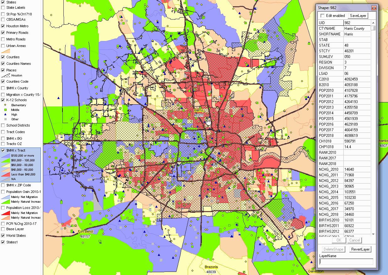 -- view created using CV XE GIS and associated MetroGIS Project Additional views and analyses; expand browser window to full screen for best view ... • Larger view of above graphic showing legend panel and mini-profile of Harris County (at marker) Miami-Fort Lauderdale-West Palm Beach, FL MSA .. start-up view of the Miami MetroGIS .. patterns of economic prosperity by neighborhood .. median household income by census tract .. click graphic for larger view showing legend; expand browser window .. zoom-in to Miami/Miami Beach; showing block groups rather than census tracts 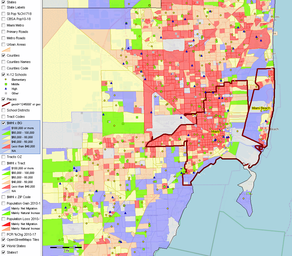 -- view created using CV XE GIS and associated MetroGIS Project Additional views and analyses; expand browser window to full screen for best view ... • Patterns of net migration by county .. larger view S&O Metro Situation & Outlook Program The Situation & Outlook (S&O) MetroGIS projects are closely related to the S&O reports and database. We use the MetroGIS projects to develop graphics that are integrated into the S&O reports. The MetroGIS project enable you to download data shown in reports for GIS and non-GIS use. Layers/Shapefiles & Data Included in Each MetroGIS Project
Individual shapefiles and related data are now included in this section. See details below. Shapefiles can be added to existing GIS projects as new layer(s). The full GIS projects section is retained for now. Providing access to individual shapefiles offers an a la carte approach to adding data to an existing GIS project. Pricing .. goto top CV XE GIS Level 1 single user license ... $695 .. required to use MetroGIS projects. Current version; selected metros: • Single MetroGIS project ... $995 .. 2nd and additional MetroGIS project ... $795 Annual subscription; selected metros (updates to geography and data throughout 12 months): • Single MetroGIS project ... $1,995 .. 2nd and additional MetroGIS project ... $1,795 Selected metros include detailed roads & shapefiles covering states intersecting with metro(s) Guide to Mapping Statistical Data GIS provides us with a way to improve collaboration; we can more easily comprehend and understand geographic relationships and patterns among "variables" and statistical data. As we reduce tabular data to visual representations, we are better able to communicate "what the data are telling us" among stakeholders and teams/committees. This second dimension, learning what the data are telling us, provides the power of creating insights for more effective decision-making. Resources described in this section can be used by most anyone with a Windows-based computer, Internet and basic familiarization with related operations. Many interested users can proceed directly to use the software and data. Others might benefit from background information and guidance in using the resources. For example, we make extensive use of terms including shapefile, geocodes, census tracts, etc. While many of these terms are described in the glossary, the User's Guide and learning modules provide extended contextual information. Selected User's Guide topics: • Getting started overview .. GIS & Geospatial Analysis • Types of vector maps and geographic objects.. Area, line, point maps • Creating a map from scratch Support Using these Resources Learn more about accessing and using demographic-economic data and related analytical tools. Join us in a Data Analytics Lab session. There is no fee for these one-hour Web sessions. Each informal session is focused on a specific topic. The open structure also provides for Q&A and discussion of application issues of interest to participants. Additional Information ProximityOne develops geodemographic-economic data and analytical tools and helps organizations knit together and use diverse data in a decision-making and analytical framework. We develop custom demographic/economic estimates and projections, develop geographic and geocoded address files, and assist with impact and geospatial analyses. Wide-ranging organizations use our tools (software, data, methodologies) to analyze their own data integrated with other data. Follow ProximityOne on Twitter at www.twitter.com/proximityone. Contact us (888-364-7656) with questions about data covered in this section or to discuss custom estimates, projections or analyses for your areas of interest. |
|
|