
|
|
|
-- tools, data & methodology to examine national scope children & education -- school, attendance zone, school district & extended geographic-statistical data • View individual district profiles below in this section. The National Children & Education Statistics (NCES) Program provides access to tools, data & methodology to examine national scope children's demographics & education-related characteristics. These resources enable stakeholders to view and analyze detailed geographic and statistical data at the school, neighborhood, community, attendance zone, school district and higher level geography. Integrate these data with drill-down demographic-economic data to the census block and intersection levels. Examine characteristics of schools, school districts and education data with related and higher level geography including urban/rural, cities, counties, metros, state and the U.S. See more about this program below in this section. Access & Support. This section is an organized gateway used to access these resources. A userid is required to access most items. See about obtaining a userid below in this section. Users are provided with support to use these resources in weekly data analytics web sessions (see below) and by extended Web-based user guides. Use this form to register for information and optionally send us a message (or call 888.364.7656). Updates, News & Staying Connected • See updates below in this section - new resources, events, related topics • Join the User Group; receive email updates. • See about school district/LEA projections described below. Contents: Summary of Program Resources Items in the following list are described in more detail below in this section. • Analytics, Blogs, Studies • Using Software Tools & Datasets • 01 Mapping & Visual Analysis Tools • 02 School District Annual Demographic-Economic Data Resources • 03 Children's Demographics & Living Environment by School District • 04 School District Enrollment & Operational Characteristics • 05 School District Finances: Sources & Uses of Funds • 06 School District Geographic Size & Characteristics • 07 School District-ZIP Code Area Relationship Table • 08 K-12 Public Schools • 09 K-12 Private Schools • 10 K-12 Public School Attendance Zones • 11 K-12 Public Schools by Urban/Rural Status • 12 Census Tract Demographic-Economic Characteristics • 13 Metropolitan Area Situation & Outlook Reports • 14 Individual School District Profiles Items shown with ● require UserID. 01 Mapping & Visual Analysis Tools - scroll section ● GIS tools & projects/datasets -- participants receive CVGIS software and ready-to-use GIS project/datasets
CVXEGIS software with state by state ready-to-use GIS project; view school district(s) in context of other geography.
Pattern of economic prosperity by neighborhood; Texas census tracts by median household income -- "start-up" view of the Texas GIS project. In just a few steps you can develop maps like this one for interactive use; perform geographic drill-down and navigation; label tracts and other geography; optionally view school districts; change attributes of patterns and/or variables used in thematic maps; add other layers; and examine the data in tabular form. 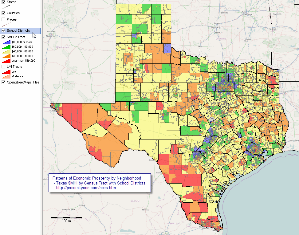 - click graphic for larger view showing school districts. - click here to view zoom-in to Dallas metro school districts. Steps to Develop the Above Map (requires Windows computer with Internet connection) 1. Install the ProximityOne CVXEGIS software ... run the CVXEGIS installer ... take all defaults during installation 2. Download the Texas Neighborhoods/School Districts GIS Project zip file. ... requires NCES UserID - see below 3. Expand the zip file to the folder c:\nces. 4. Initial start-up. ... after completing the above steps and with CVGIS running (use desktop icon) ... use File>Open>Dialog to open the project file named c:\nces\tx1.gis ... the map view shown above should appear. About the GIS Project The GIS project includes several shapefiles, represented as layers, and OpenStreetMaps (OSM) as an optional base layer. Use of the OSM requires an Internet connection. The OSM layer is optional. It can be deleted from the project, However, the automatic roads and topology view is then not available. Other than the OSM layer, there are no Internet dependencies; CVGIS and this project operate without Internet. The layers include U.S. by states, state by county, state by city/place, state by school district, state by census tract. 02 School District Annual Demographic-Economic Data Resources - goto top Interactive tables with datasets & GIS projects Dates shown to right of bullet refer to ACS program vintage; not all data ACS-sourced. ● 2014: General Demographics | Social | Economic | Housing (all districts, 5-year estimates) ● 2015: General Demographics | Social | Economic | Housing (all districts, 5-year estimates) ● 2015: General Demographics | Social | Economic | Housing (districts 65,000+ pop, 1-year estimates) ● 2012: School District Demographic-Economic Profiles - individual district profiles ● 2015: School District Demographic-Economic Profiles - individual district profiles ● School District Demographic-Economic Trends 2010-2015 .. most recent estimates (2015) available for each/all school districts. ● School District Demographic-Geographic Change 2000-2010 03 Children's Demographics & Living Environment by School District - goto top Children's demographic economic characteristics by type of enrollment Interactive tables with optional datasets & GIS projects ● 2012: ACS 2012 School District Special Tabulation ● 2014: ACS 2014 School District Special Tabulation ● 2015: ACS 2015 School District Special Tabulation (available June 2017) 04 School District Enrollment & Operational Characteristics - goto top Administratively reported data (by schools and school districts) Interactive tables, datasets & GIS projects ● School District Enrollment & Operational Characteristics SY 2012-13 ● School District Enrollment & Operational Characteristics SY 2014-15 05 School District Finances: Sources & Uses of Funds - goto top Fiscal data reported by school district Interactive tables with optional datasets & GIS projects ● School District Finances FY 2014 ● School District Finances FY 2015 06 School District Geographic Size & Characteristics - goto top Interactive tables with optional datasets & GIS projects ● School District Geographic Characteristics as of Jan 2008 ● School District Geographic Characteristics as of Jan 2016 ● School District Geographic Characteristics as of Jan 2017 (available Sept 2017) 07 School District-ZIP Code Area Relationship Table - goto top Interactive tables with optional datasets & GIS projects ● School District-ZIP Code Area Relationship Table 08 K-12 Public Schools - goto top Administratively reported data (by schools and school districts) Interactive tables with optional datasets & GIS resources ● K-12 Public Schools SY 2012-13 ● K-12 Public Schools SY 2014-15 (available February 2017) 09 K-12 Private Schools - goto top Administratively reported data (by survey of private schools Interactive tables with optional datasets & GIS resources ● K-12 Private Schools SY 2010-11 ● K-12 Private Schools SY 2013-14 (available February 2017) 10 School Attendance Zones - goto top Public school attendance zones Interactive tables with optional datasets & GIS resources ● School Attendance Zones 2013-14 SY ● School Attendance Zones 2014-15 SY (available Summer 2017) 11 K-12 Public Schools by Urban/Rural Status - goto top Each school location coded to census block; associated with urban area Interactive tables with optional datasets & GIS resources ● K-12 Public Schools by Urban/Rural Status 2012-13 SY ● K-12 Public Schools by Urban/Rural Status 2014-15 SY 12 Census Tract Demographic-Economic Characteristics - goto top Neighborhood-oriented geographic drill-down data Interactive tables with optional datasets & GIS resources ● General Demographics | Social | Economic | Housing ● Census Tract Estimates & Projections; 2010-2022 ... about census tracts 13 Metropolitan Area Situation & Outlook Reports - goto top School districts by metro; integrated with other data & geography ● Metro S&O Reports 14 Illustrative School District Profiles - scroll section - goto top School district profiles are updated throughout the year and are available for any district. Details of updates are provided in the following illustrative profiles. The profiles feature multi-sourced data to provide a more holistic view of the district characteristics. Reference to "with ACS 1-year data" means that 02 sections of the profile use ACS 1-year estimates (available district 65,000 population and over). Where there is no ACS reference, ACS 5-year data are used (available for all districts). In general, the 1-year estimates should be used when available (more recent, more accurate) but there are reasons to prefer the 5-year estimates even when 1-year estimates are available. See more about using 1-year and 5-year estimates. Scroll down to view more districts ...
Arizona
• Flowing Wells USD, AZ • Scottsdale Unified, AZ .. with ACS 1-year data • Sunnyside USD, AZ California • Salinas Elementary School District, CA .. with ACS 1-year data • Salinas Union High School District, CA .. with ACS 1-year data • San Jose Unified, CA .. with ACS 1-year data Colorado • Poudre School District, CO (Fort Collins, CO) .. with ACS 1-year data Florida • Hillsborough County School District, FL .. with ACS 1-year data Georgia • Richmond County School District, GA (Augusta, GA) .. with ACS 1-year data Hawaii • Hawaii Department of Education, HI (Hawaii statewide) .. with ACS 1-year data Indiana • Lake Ridge Schools, IN Kansas • Iola Public Schools, KS Massachusetts • Danvers School District, MA Minnesota • Anoka-Hennepin Public School District, MN .. with ACS 1-year data Missouri • Lee's Summit Public Schools, MO .. with ACS 1-year data • Nevada Public Schools, MO New York • Albany City School District, NY .. with ACS 1-year data • Syracuse CSD, NY .. with ACS 1-year data • Syosset Central School District, NY • Rome CSD, NY North Carolina • Charlotte-Mecklenburg Schools, NC .. with ACS 1-year data • Guilford County Schools, NC .. with ACS 1-year data • Wake County Schools, NC .. with ACS 1-year data Oklahoma • Cache Schools, OK • Tulsa Public Schools, OK .. with ACS 1-year data South Carolina • Richland School District 1, SC (Columbia, SC) .. with ACS 1-year data • Richland School District 2, SC (Columbia, SC) .. with ACS 1-year data Texas • Alief ISD, TX .. with ACS 1-year data • Blue Ridge ISD, TX • Clear Creek ISD, TX .. with ACS 1-year data • Cypress-Fairbanks ISD, TX .. with ACS 1-year data • Friendswood ISD, TX • Longview ISD, TX • McKinney ISD, TX .. with ACS 1-year data • Royse ISD, TX • Sunnyvale ISD, TX Virginia • Alexandria Public Schools, VA .. with ACS 1-year data Washington • Seattle Public Schools, WA .. with ACS 1-year data Wisconsin • Wautoma Area School District, WI NCES Program Membership; UserID and Resource Access - goto top NCES is a fee-based membership program. Member benefits include: • assigned UserID enabling access to privileges and resources not otherwise available. .. CVGIS software with ready-to-use state by neighborhood/school district GIS project. see 01 above .. Mapping & Visual Analysis Tools .. access to NCES member only data resources and access/analysis tools (red-dotted items noted above). • updates on new developments and data/tool availability • advisory and technical support on how to use tools and data. The UserID fee is charged once per year. • Individual UserID -- $295 • Small Group (2-10) Users -- $995 • Join here. Upon receiving your registration, we will send you an e-mail with your UserId and more information. Updates: New Resources, Events & Related Topics - goto top • 01/20/17. ACS 2015 School District Demographic-Economic Interactive Tables ,, here .. 2015: General Demographics | Social | Economic | Housing (all districts, 5-year estimates) .. and via links in Section 02 above .. notes about these sections - all tables include "P517" (population ages 5-17 years) and "P517PCT" (%population ages 5-17 years) - P517 & P517PCT are the rightmost columns in each table - use the P517 Min & Max button below table to filter records based on P517 value Analytics, Blog Posts, Studies - goto top • K-12 Schools Data Analytics Using Software Tools & Datasets - goto top • ChartGraphics, Population Pyramids & School Districts School District/LEA Projections & Time Series Data We develop/maintain national scope up-to-date administrative records data, reported by school districts and state education agencies, for each school district/LEA. These annual time series data are available from 2010 forward and include enrollment by grade, race/ethnicity and other items. Annual administrative records data now extend through the 2015-16 school year. Data for the 2016-17 school year are now in development as part of our continuous update program. These data may be accessed by NCES members. Projections. Using predictive models, we use the administrative records data in combination with other data to project enrollment by grade and related items for each school district/LEA. Projections are developed as a part of the Situation & Outlook 5-year estimates program. Current estimates and projections are available through 2021. The "2017 vintage annual updates" (updates July of each year) will extend the projections to cover the period 2010 through 2022. A modified version of the 2016-17 school year data are used as the "2017 vintage estimates". Accessing Time-Series Data & Projections. Starting with the "2017 vintage annual updates" (July 2017) NCES members may access national scope interactive tables including data for 2010-2022 for all school districts/LEAs -- school districts/LEAs as defined in the corresponding ACS 2015 General Demographics table. More detailed data (e.g., enrollment by grade) are available by individual district/LEA on a fee basis. About the NCES Program - goto top The National Children & Education Statistics (NCES) Program is developed and operated by ProximityOne. Many of the data provided in the ProximityOne NCES are related to data also provided by the U.S. National Center for Education Statistics (many developed, in turn, by other Federal statistical agencies). The ProximityOne NCES program has no business affiliation with the U.S. National Center for Education Statistics. ProximityOne reorganizes multi-sourced data and makes these data available in a more consumable structure compared to original source data structure and accessibility. Data are made available using both Web-based interactive tools and a file structure suitable for GIS and data analytics applications. This is one way that we "value-add" the source data. All of the tools in the ProximityOne NCES program are developed and maintained by ProximityOne. Data made available through the program are derived from multiple sources including the Census Bureau and other Federal statistical agencies. The ProximityOne NCES program also provides data not available elsewhere. We provide unique resources enabling stakeholders to access and use children's demographics and education statistics. Warren Glimpse, principal at ProximityOne, is developer of the NCES Program. A hands-on statistician, modeler, coder and data developer/integrator, Glimpse developed many Census Bureau data access programs now in operation, the first set of national scale school district boundary files, the original School District Data Book, the State Data Center Program, and GBF/DIME used as prototype for the Census Bureau TIGER/Line digital map database. Glimpse works with private and public schools and wide-ranging Federal, state, local education agencies on matters concerning data development, access, analysis and planning. Connect with Warren on LinkedIn ProximityOne User Group NCES users are automatically enrolled in the ProximityOne User Group. Keep up-to-date with new developments relating to accessing and using data on children's demographics, schools and school districts. Receive updates and access to tools and resources available only to members. Support Using these Resources Participate in weekly Data Analytics Lab sessions to learn about accessing and using these and related data. Topics covered include: - questions that you have. - navigation through use of program resources. - using your data with these resources. - developing and using projections with these resources. There is no fee for these one-hour Web sessions. Each informal session is structured around selected topics. The open structure provides for Q&A and discussion of application issues of interest. Additional Information ProximityOne develops geodemographic-economic data and analytical tools and helps organizations knit together and use diverse data in a decision-making and analytical framework. We develop custom demographic/economic estimates and projections, develop geographic and geocoded address files, and assist with impact and geospatial analyses. Wide-ranging organizations use our tools (software, data, methodologies) to analyze their own data integrated with other data. Follow ProximityOne on Twitter at www.twitter.com/proximityone. Contact us (888-364-7656) with questions about data covered in this section or to discuss custom estimates, projections or analyses for your areas of interest. |
|
|