ProximityOne Home Page Resources to create and apply insight


  Hawaii 2014 GIS Main
  • Profiles & Reports
  • API Data Integration
  • Site Analysis

  Hawaii Online
    Comparative Analysis

  Situation & Outlook

  Related Sections
  - Applications Gallery
  - States
  - School Districts
  - Metros
  - Congressional District
  - Counties
  - Tracts/Neighborhoods
  - Block Groups
  - Census Blocks
  - ZIP Codes
  - Urban Areas

  Estimates-Projections
  - 2060 Demographic
    ... all county interactive table
  - 2030 Demographic-Economic
  - Single Year of Age

  GIS Thematic Mapping
    Visual Analysis Tools

  Ranking Tables
    National Scope
    Demographic Change
    2000-2010
  - States
  - Metros
  - Congressional District
  - School Districts
  - Counties
  - Cities/Places
  - Census Tracts


Hawaii 2014 GIS Project
  ... overview of structure and use
Decision-Making Information
  ProximityOne
  information resources & solutions
  (888) DMI-SOLN
  (888) 364-7656


Houston Metro by County


U.S. by Metro Patterns of Economic Prosperity


Decision-Making Information Blog
Examining Diversity 1960-2060

Support & Technical Assistance
help using these resources


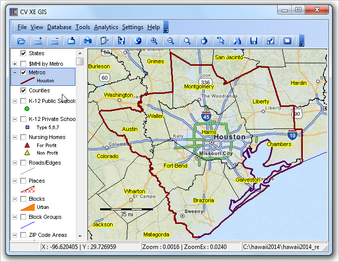
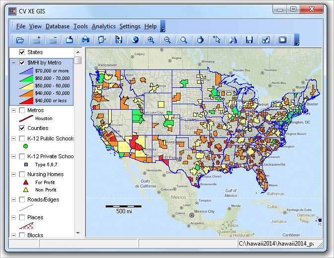
This section provides an overview of the Hawaii 2014 GIS Project (Hawaii2014) structure and use. This GIS project is updated annually to reflect use of the most current TIGER and related shapefiles. The Hawaii2014 project makes use of the TIGER 2014 shapefiles and related recently updated shapefiles. The Hawaii2015 GIS project (August 2015) will reflect use of the 2015 file.

Distinguishing characteristics of the Hawaii2014 GIS project is that it brings together use of selected primary Census Bureau political and statistical geography integrated with demographic-economic data. Non-Census shapefiles/layers and subject matter data include K-12 schools and Open Street Map (OSM).

Downloadable subject matter datasets are also provided that can be merged with shapefiles for thematic mapping and geospatial analysis and/or used directly for other applications. See more information about datatsets below in this section.

U.S. National Scope Applications
The project file set includes several U.S. national scope shapefiles. Use the project fileset to create reference and pattern views/analyses. Click graphics at right to view examples: Houston, TX by county and U.S. by metro patterns of economic prosperity. Create similar views for any area.

Updates. See update details below. This project updates with some frequency. The ACS 2013 5 year estimates will be used to update the tract and block group shapefiles in December 2014. Other layers will be added. Check the date on your local version of c:\hawaii2014\hawaii2014.gis. If the updated date is more recent that your local version, follow step 3 in Using the Hawaii 2014 GIS Project below.

The purposes of the Hawaii2014 GIS project include:
  • providing a downloadable GIS base project for Hawaii-centric GIS applications.
  • features frequently updated versions reflecting most current TIGER & related shapefiles.
  • integrates most recent demographic-economic data: ACS 2012, ACS 2013 & other
  • a GIS project "template" that may be emulated to develop similar GIS projects for other areas.
  • illustration of how to use a GIS project using the CV XE GIS software.
  • GIS project used in weekly Web sessions, adjusted to topics of specific sessions.

Related Sections/Web Pages
  • Demographic-Economic Profiles/Reports
  • Demographic-Economic Data Extraction Tool
  • SiteAnalysis Tool

Hawaii 2014 GIS Project Start-up View

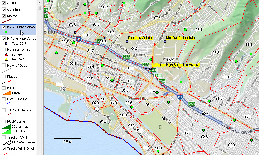
View created using CV XE GIS. Click graphic for larger view.
See additional views below in this section.

Using the Hawaii 2014 GIS Project
ProximityOne User Group (join now, no fee) may download and use the Hawaii GIS Project.
  1. Install CV XE GIS (Windows-based computer)
  2. After installing, key in your User Group ID ... with CV XE running,
      .. use Settings>Start-up; enter your ID in the Key edit box; save the form; restart CV XE.
  3. Create the folder c:\hawaii2014
  4. Expand GIS Project Fileset to c:\hawaii2014. See terms of use.
      .. requires User Group ID ... if prompted for "allow overwrite" reply yes.
  5. With CV XE GIS running, open the "Hawaii2014" GIS project.
      File>Open>Dialog and select c:\hawaii2014\hawaii2014.gis
  6. Click this link to view start-up project view.

Hawaii 2014 GIS Project Structure
Shapefiles and layers included in the Hawaii 2014 GIS Project are managed by the project file named "hawaii2014.gis." The project file contains layer references to shapefiles and related start-up attributes. The layers and shapefiles are summarized in the table shown below. All shapefiles are available on a national scale from ProximityOne.
Layer# Layer Name (in project)
& Description
Layer Source/ShapefileNotes
1states1
U.S. by state
C:\hawaii2014\cb_2013_us_state_500k.shp TIGER 2014 (smoothed version)
2counties
U.S. by county
C:\hawaii2014\cb_2013_us_county_500k.shp TIGER 2014 (smoothed version)
3cbsa
U.S. by Feb 2013 CBSA
C:\hawaii2014\cb_2013_us_cbsa_500k.shp TIGER 2014 (smoothed version)
4pubsch1112pts
State K-12 public schools
C:\hawaii2014\pubsch1112pts_15.shp More about these data
Fields & Record Structure
5prvsch1112pts
State K-12 private schools
C:\hawaii2014\prvsch1112pts_15.shp More about these data
Fields & Record Structure
6nursinghomes
State Nursing Homes
C:\hawaii2014\nhlocations_hi.shpMore about these data
Fields & Record Structure (xls)
7edges
County Edges/Roads
C:\hawaii2014\tl_2014_15003_edges.shp TIGER 2014
More about roads/edges; set state query to HI
8places
State by city/place
C:\hawaii2014\cb_2013_15_place_500k.shp TIGER 2014 (smoothed version)
More about places
9blocks
State by Census 2010 census block
C:\hawaii2014\tl_2014_15_tabblock10.shp TIGER 2014
Total population & housing units with urban/rural status integrated from Census 2010 SF1 urban/rural update
More about census blocks
10block groups
State by Census 2010 block group
C:\hawaii2014\cb_2013_15_bg_500k.shp TIGER 2014 (smoothed version)
More about block groups
11ZIP code areas
State by ZIP code area
cb_2013_us_zcta510_500k_15.shp TIGER 2014 (smoothed version)
More about ZIP code areas
12puma2010
State by Census 2010 PUMA
C:\hawaii2014\puma2010gz_15.shp TIGER 2014 (smoothed version)
More about PUMA
Hawaii PUMA maps
More about PUMS
13tracts1
State by Census 2010 census tracts
C:\hawaii2014\cb_2013_15_tract_500k.shp TIGER 2014 (smoothed version)
More about tracts
14tracts2
State by Census 2010 census tracts
C:\hawaii2014\cb_2013_15_tract_500k.shp TIGER 2014 (smoothed version)
More about diversity code
15tracts3
State by Census 2010 census tracts
C:\hawaii2014\cb_2013_15_tract_500k.shp TIGER 2014 (smoothed version)
More about neighborhood diversity
16mapquest_osm
Open Street Map: global
C:\hawaii2014\mapquest openstreetmaps tiles.ttkwponly layer that requires Internet
More about OSM
17states2
U.S by state
C:\hawaii2014\cb_2013_us_state_500k.shpsame as layer 1

Items in Tracts Layer/Shapefile
General Demographics Items
P2010 Total population (Census 2010; remaining items ACS 2011 5 year estimates)
AGE AND GENDER
  D001     Total population
  D002 Male
  D003 Female
  D004 Under 5 years
  D005 5 to 9 years
  D006 10 to 14 years
  D007 15 to 19 years
  D008 20 to 24 years
  D009 25 to 34 years
  D010 35 to 44 years
  D011 45 to 54 years
  D012 55 to 59 years
  D013 60 to 64 years
  D014 65 to 74 years
  D015 75 to 84 years
  D016 85 years and over
  D017 Median age (years)
  D018 18 years and over
  D019 21 years and over
  D020 62 years and over
  D021 65 years and over
  D022     18 years and over
  D023 Male
  D024 Female
  D025     65 years and over
  D026 Male
  D027 Female
RACE
  D028     Total population
  D029 One race
  D030 Two or more races
  D031 One race
  D032     White
  D033     Black or African American
  D034     American Indian and Alaska Native
  D039     Asian
  D047     Native Hawaiian and Other Pacific Islander
  D052     Some other race
  D053 Two or more races
  D066 Hispanic or Latino (of any race)
  D067     Mexican
  D068     Puerto Rican
  D069     Cuban
  D070     Other Hispanic or Latino

Social Characteristics Items
HOUSEHOLDS BY TYPE
  S001     Total households
  S002 Family households (families)
  S010 Nonfamily households
  S015   Average household size
  S016   Average family size
RELATIONSHIP
  S017       Population in households
SCHOOL ENROLLMENT
  S052     Population 3 years and over enrolled in school
  S053 Nursery school, preschool
  S054 Kindergarten
  S055 Elementary school (grades 1-8)
  S056 High school (grades 9-12)
  S057 College or graduate school
EDUCATIONAL ATTAINMENT
  S058     Population 25 years and over
  S059 Less than 9th grade
  S060 9th to 12th grade, no diploma
  S061 High school graduate (includes equivalency)
  S062 Some college, no degree
  S063 Associate's degree
  S064 Bachelor's degree
  S065 Graduate or professional degree
  S066 Percent high school graduate or higher
  S067 Percent bachelor's degree or higher
RESIDENCE 1 YEAR AGO
  S078     Population 1 year and over
  S079 Same house
  S080 Different house in the U.S.
  S081     Same county
  S082     Different county
  S083         Same state
  S084         Different state
  S085 Abroad
LANGUAGE SPOKEN AT HOME
  S110     Population 5 years and over
  S111 English only
  S112 Language other than English
  S113         Speak English less than "very well"
  S114     Spanish
  S115         Speak English less than "very well"

Economic Characteristics Items
EMPLOYMENT STATUS
  E001         Population 16 years and over
  E002 In labor force
  E003     Civilian labor force
  E004         Employed
  E005         Unemployed
  E006     Armed Forces
  E007 Not in labor force
  E008     Civilian labor force
  E009 Percent Unemployed
INDUSTRY
  Civilian employed population 16 years and over
  E033 Agriculture, forestry, fishing and hunting, and mining
  E034 Construction
  E035 Manufacturing
  E036 Wholesale trade
  E037 Retail trade
  E038 Transportation and warehousing, and utilities
  E039 Information
  E040 Finance and insurance, and real estate and rental and leasing
  E041 Professional, scientific, and management, and administrative and waste management services
  E042 Educational services, and health care and social assistance
  E043 Arts, entertainment, and recreation, and accommodation and food services
  E044 Other services, except public administration
  E045 Public administration
INCOME AND BENEFITS (IN 2010 INFLATION-ADJUSTED DOLLARS)
  Total households
  E052 Less than $10,000
  E053 $10,000 to $14,999
  E054 $15,000 to $24,999
  E055 $25,000 to $34,999
  E056 $35,000 to $49,999
  E057 $50,000 to $74,999
  E058 $75,000 to $99,999
  E059 $100,000 to $149,999
  E060 $150,000 to $199,999
  E061 $200,000 or more
  E062 Median household income (dollars)
  E063 Mean household income (dollars)
  E075     Families
  E076 Less than $10,000
  E077 $10,000 to $14,999
  E078 $15,000 to $24,999
  E079 $25,000 to $34,999
  E080 $35,000 to $49,999
  E081 $50,000 to $74,999
  E082 $75,000 to $99,999
  E083 $100,000 to $149,999
  E084 $150,000 to $199,999
  E085 $200,000 or more
  E086 Median family income (dollars)
  E087 Mean family income (dollars)
PERCENT FAMILIES & PEOPLE W/INCOME PAST 12 MONTHS BELOW POVERTY LEVEL
  E119 All families
  E120     With related children under 18 years
  E121         With related children under 5 years only
  E122 Married couple families
  E123     With related children under 18 years
  E124         With related children under 5 years only
  E125 Families with female householder, no husband present
  E126     With related children under 18 years
  E127         With related children under 5 years only
  E128 All people

Housing Characteristics Items
HOUSING OCCUPANCY
  H001     Total housing units
  H002 Occupied housing units
  H003 Vacant housing units
  H004 Homeowner vacancy rate
  H005 Rental vacancy rate
UNITS IN STRUCTURE
  H006     Total housing units
  H007 1-unit, detached
  H008 1-unit, attached
  H009 2 units
  H010 3 or 4 units
  H011 5 to 9 units
  H012 10 to 19 units
  H013 20 or more units
  H014 Mobile home
  H015 Boat, RV, van, etc.
YEAR STRUCTURE BUILT
  H016     Total housing units
  H017 Built 2005 or later
  H018 Built 2000 to 2004
  H019 Built 1990 to 1999
  H020 Built 1980 to 1989
  H021 Built 1970 to 1979
  H022 Built 1960 to 1969
  H023 Built 1950 to 1959
  H024 Built 1940 to 1949
  H025 Built 1939 or earlier
HOUSING TENURE
  Occupied housing units
  H045 Owner-occupied
  H046 Renter-occupied
  H047 Average household size of owner-occupied unit
  H048 Average household size of renter-occupied unit
YEAR HOUSEHOLDER MOVED INTO UNIT
  H049     Occupied housing units
  H050 Moved in 2005 or later
  H051 Moved in 2000 to 2004
  H052 Moved in 1990 to 1999
  H053 Moved in 1980 to 1989
  H054 Moved in 1970 to 1979
  H055 Moved in 1969 or earlier
OCCUPANTS PER ROOM
  Occupied housing units
  H076 1.00 or less
  H077 1.01 to 1.50
  H078 1.51 or more
VALUE
  H079     Owner-occupied units
  H080 Less than $50,000
  H081 $50,000 to $99,999
  H082 $100,000 to $149,999
  H083 $150,000 to $199,999
  H084 $200,000 to $299,999
  H085 $300,000 to $499,999
  H086 $500,000 to $999,999
  H087 $1,000,000 or more
  H088 Median (dollars)
SELECTED MONTHLY OWNER COSTS (SMOC)
  H092 Housing units with a mortgage
  H093 Less than $300
  H094 $300 to $499
  H095 $500 to $699
  H096 $700 to $999
  H097 $1,000 to $1,499
  H098 $1,500 to $1,999
  H099 $2,000 or more
  H100 Median (dollars)
GROSS RENT
  H124 Occupied units paying rent
  H125 Less than $200
  H126 $200 to $299
  H127 $300 to $499
  H128 $500 to $749
  H129 $750 to $999
  H130 $1,000 to $1,499
  H131 $1,500 or more
  H132 Median (dollars)
  H133 No rent paid


Subject Matter Datasets
Downloadable subject matter datasets are listed below that can be merged with shapefiles for thematic mapping and geospatial analysis and/or used directly for other applications.

2012 American Community Survey 5 year demographic profile datasets
  • Hawaii census tracts: expand this zip file to hawaii2014 folder (c:\hawaii2014).
      expands to four files: acs0812tdp1_15.dbf .. acs0812tdp2_15.dbf .. acs0812tdp3_15.dbf .. acs0812tdp4_15.dbf
      click filename link to view subject matter field names and descriptions (in scroll section on target page).

State Shapefile Attributes
STATEFP15
STATENS01779782
AFFGEOID0400000US15
GEOID15
STUSPSHI
NAMEHawaii
LSAD00
ALAND16634306900
AWATER11777540017

County Shapefile Attributes
STATEFP15
COUNTYFP003
COUNTYNS00365281
AFFGEOID0500000US15003
GEOID15003
NAMEHonolulu
LSAD06
ALAND1555614857
AWATER4054819637

Layer populated with Census population (2010-2013) estimates.
Note this is a U.S. by county national scope file.
See county population estimates for more information.


CBSA Shapefile Attributes
CSAFP
CBSAFP46520
AFFGEOID310M200US46520
GEOID46520
NAMEUrban Honolulu, HI
LSADM1
ALAND1555614857
AWATER4054819637

Layer populated with ACS 2013 1 year estimates.
Note this is a U.S. by CBSA national scope file.
See Metro Demographic Economic Patterns for more information.


Public Schools Shapefile Attributes
SCHNAMEducation Laboratory - a Hawaii New Century Pcs
LEANMHawaii Department of Education
SCHID150003000273
FIPST15
LEAID1500030
SCHNO00273
STID001
SEASCH1-543
GEOIDBLK150030027021002
PHONE8089567833
MSTREE1776 University Ave
MCITYHonolulu
MSTATEHI
MZIP96822
MZIP42463
LSTREE1776 University Ave
LCITYHonolulu
STATEHI
LZIP96822
LZIP42463
TYPE1
STATUS1
UNION000
ULOCAL11
LATCOD21.297947
LONCOD-157.821646
STCTY15003
CONAMEHonolulu County
CDCODE1501
CDCODE_1121501
BIES2
RECONSTYN
RECONSTF2
SMEMPUP2
ISMEMPUPP
SFTEPUP2
ISFTEPUPP
SFLE2
ISFLEP
SPFEMALE2
ISPFEMALEP
SPWHITE2
ISPWHITEP
SPELM2
ISPELMP
FTE37.8
GSLOPK
GSHI12
PKOFFRD1
KGOFFRD1
G01OFFRD1
G02OFFRD1
G03OFFRD1
G04OFFRD1
G05OFFRD1
G06OFFRD1
G07OFFRD1
G08OFFRD1
G09OFFRD1
G10OFFRD1
G11OFFRD1
G12OFFRD1
UGOFFRD1
LEVEL4
TITLEISTAT6
TITLEI2
STITLIN
MAGNETN
CHARTR1
SHARED2
FRELCH34
REDLCH21
TOTFRL55
RACECAT7
PK0
KG11
G0110
G0210
G0310
G0410
G0510
G0656
G0755
G0856
G0956
G1055
G1156
G1253
UG0
ENROLLMENT448
AM2
AMALM1
AMALF1
ASIAN223
ASALM105
ASALF118
HISP9
HIALM7
HIALF2
BLACK6
BLALM4
BLALF2
WHITE74
WHALM37
WHALF37
PACIFIC109
HPALM59
HPALF50
TR25
TRALM14
TRALF11
TOTETH448

Private Schools Shapefile Attributes
ID00326882
SCHNAMEPunahou School
ADDR1601 Punahou St
CITYHonolulu
STHI
ZIP96822
ZIP4
CTY003
CTYNAMEHonolulu
REGION4
STFIPS15
ULOCALE1211
LAT21.302798
LON-157.828524
LOGR20123
HIGR201217
LOGRADEKG
HIGRADE12
TABFLAG1
SCH_TYPE7
RELIG
ORIENT30
DIOCESE
LEVEL3
SIZE6
STUDENTS3743
MALES1841
TEACHERS319.3
S_T_RATIO11.72
UCOMMTYP1
TOT_HOURS7
STDP_AIAN0.08
STDP_ASIAN44.51
STDP_NHOPI1.68
STDP_HISP2.51
STDP_WHITE25.22
STDP_BLACK0.48
STDP_TOM25.51
STDUG
STDPK0
STDKG150
STDTK
STDT1
STD01150
STD02151
STD03150
STD04201
STD05200
STD06290
STD07368
STD08369
STD09425
STD10441
STD11421
STD12427
STDTOT3743
STD_HISP94
STD_WHITE944
STD_BLACK18
STD_ASIAN1666
STD_NHOPI63
STD_AIAN3
STD_TOM955
COED1
STD_MALE1841
STD_12LY1
NUM_12LY430
PCT_4YR99
KG_LENGTH1
KG_DPW5
TCH_FT306
TCH_754
TCH_5012
TCH_256
TCH_U250
TCH_TOT328
TYPE_SCH1
HM_SCHL2
PVT_HOME2
RELIG_STAT2
SCH_AFFIL0
RELG_ORIEN0
TYPE_CATH
NO_ASSOC0
P4550
P4600
P4650
P4670
P4680
P4700
P4800
P4850
P4900
P4920
P4950
P5000
P5050
P5100
P5150
P5200
P5220
P5250
P5300
P5350
P5400
P5420
P5450
P5500
P5550
P5750
P5800
P5850
P5900
P6000
P6020
P6050
P6100
P6201
P6221
P6250
P6300
P6350
P6400
P645170
P6507
P6550
P6601
P66540

Nursing Home Attributes
PROVNUM125042
PROVNAMEOAHU CARE FACILITY
ADDRESS1808 SOUTH BERETANIA STREET
CITYHONOLULU
STATEHI
ZIP96826
TLID203237634
TLIDSL
STATUSG
GEOID150030026003001
PHONE808973190
COUNTY_NAMHonolulu
OWNERSHIPFor profit - Partnership
BEDCERT82
RESTOT78
CERTMedicare and Medicai
INHOSPNO
LBNLegal Business Name Not Available
PARTDATE9/14/1995
CCRCFACN
SFFN
CH_12MOSN
RESFAMResident
SPRINKLERYes
RATING3
RATING_FN
SURVEYRATE2
SRVRATFN
QUALRATE5
QUALRAT_FN
ST_RATING2
ST_RATING1
RN_ST_RATI4
RN_ST_RAT1
STAFF_FLAG
PT_ST_FLAG
WGT1
AIDHRD2.16
VOCHRD0.18
RNHRD0.82
TOTLICHRD0.99
TOTHRD3.15
PTHRD0.07
EXP_AIDE2.57
EXP_LPN0.62
EXP_RN0.95
EXP_TOTAL4.13
ADJ_AIDE2.07
ADJ_LPN0.23
ADJ_RN0.64
ADJ_TOTAL3.08
CYC1_DEFS12
CYC1_A12
CYC1_B0
CYC1_C56
CYC1_DATE3/25/2013
WGTSCORE50.667
INCIDENT0
CMPLNT0
FINE_CNT1
FINE_TOT1625
PAYDEN_CNT1
TOTPENCNT2
FILEDATE10/1/2014

Edges/Roads Shapefile Attributes
STATEFP15
COUNTYFP003
TLID203237583
TFIDL200250121
TFIDR200251076
MTFCCS1400
FULLNAMEPunahou St
SMID6465
LFROMADD1600
LTOADD1798
RFROMADD1601
RTOADD1799
ZIPL96822
ZIPR96822
FEATCATS
HYDROFLGN
RAILFLGN
ROADFLGY
OLFFLGN
PASSFLG
DIVROADN
EXTTYPN
TTYP
DECKEDROADN
ARTPATHN
PERSIST
GCSEFLGN
OFFSETLN
OFFSETRN
TNIDF55573842
TNIDT55573841

Places Shapefile Attributes
STATEFP15
PLACEFP71550
PLACENS02630783
AFFGEOID1600000US1571550
GEOID1571550
NAMEUrban Honolulu
LSAD57
ALAND156747400
AWATER20484151

Block Shapefile Attributes
STATEFP1015
COUNTYFP10003
TRACTCE10002702
BLOCKCE101012
GEOID10150030027021012
NAME10Block 1012
MTFCC10G5040
UR10U
UACE1089770
UATYP10U
FUNCSTAT10S
ALAND10173162
AWATER100
INTPTLAT10+21.3033147
INTPTLON10-157.8293291
POP1000
HU1000
UA89770
URU

Block Group Shapefile Attributes
STATEFP15
COUNTYFP003
TRACTCE002702
BLKGRPCE1
AFFGEOID1500000US150030027021
GEOID150030027021
NAME1
LSADBG
ALAND799414
AWATER0

ZIP Code Area Shapefile Attributes
ZCTA5CE1096822
AFFGEOID108600000US96822
GEOID1096822
ALAND1021240475
AWATER100

This layer is populated with Census 2010 Demographic Profile Summary File subject matter items.
See Cen2010 DPSF for more information.
1. Gender and Age 
  Universe: Total population 
  Total:d001001
    Under 5 yearsd001002
    5 to 9 yearsd001003
    10 to 14 yearsd001004
    15 to 19 yearsd001005
    20 to 24 yearsd001006
    25 to 29 yearsd001007
    30 to 34 yearsd001008
    35 to 39 yearsd001009
    40 to 44 yearsd001010
    45 to 49 yearsd001011
    50 to 54 yearsd001012
    55 to 59 yearsd001013
    60 to 64 yearsd001014
    65 to 69 yearsd001015
    70 to 74 yearsd001016
    75 to 79 yearsd001017
    80 to 84 yearsd001018
    85 years and overd001019
  Male:d001020
    Under 5 yearsd001021
    5 to 9 yearsd001022
    10 to 14 yearsd001023
    15 to 19 yearsd001024
    20 to 24 yearsd001025
    25 to 29 yearsd001026
    30 to 34 yearsd001027
    35 to 39 yearsd001028
    40 to 44 yearsd001029
    45 to 49 yearsd001030
    50 to 54 yearsd001031
    55 to 59 yearsd001032
    60 to 64 yearsd001033
    65 to 69 yearsd001034
    70 to 74 yearsd001035
    75 to 79 yearsd001036
    80 to 84 yearsd001037
    85 years and overd001038
  Female:d001039
    Under 5 yearsd001040
    5 to 9 yearsd001041
    10 to 14 yearsd001042
    15 to 19 yearsd001043
    20 to 24 yearsd001044
    25 to 29 yearsd001045
    30 to 34 yearsd001046
    35 to 39 yearsd001047
    40 to 44 yearsd001048
    45 to 49 yearsd001049
    50 to 54 yearsd001050
    55 to 59 yearsd001051
    60 to 64 yearsd001052
    65 to 69 yearsd001053
    70 to 74 yearsd001054
    75 to 79 yearsd001055
    80 to 84 yearsd001056
    85 years and overd001057
2. Median Age by Gender 
  Universe: Total population 
  Median age- 
  Total Populationd002001
  Maled002002
  Femaled002003
3. Gender for the Population 16 Years and Over 
  Universe: Population 16 years and over 
  Total:d003001
  Maled003002
  Femaled003003
4. Gender for the Population 18 Years and Over 
  Universe: Population 18 years and over 
  Total:d004001
  Maled004002
  Femaled004003
5. Gender for the Population 21 Years and Over 
  Universe: Population 21 years and over 
  Total:d005001
  Maled005002
  Femaled005003
6. Gender for the Population 62 Years and Over 
  Universe: Population 62 years and over 
  Total:d006001
  Maled006002
  Femaled006003
7. Gender for the Population 65 Years and Over 
  Universe: Population 65 years and over 
 nbsp; Total:d007001
  Maled007002
  Femaled007003
8. Race 
  Universe: Total population 
  Total:d008001
  Population of one race:d008002
    Whited008003
    Black or African Americand008004
    American Indian and Alaska Natived008005
    Asian:d008006
    Asian Indiand008007
    Chinesed008008
    Filipinod008009
    Japanesed008010
    Koreand008011
    Vietnamesed008012
    Other Asiand008013
    Native Hawaiian and Other Pacific Islander:d008014
    Native Hawaiiand008015
    Guamanian or Chamorrod008016
    Samoand008017
    Other Pacific Islanderd008018
    Some Other Raced008019
  Population of Two or More Racesd008020
    White; American Indian and Alaska Natived008021
    White; Asiand008022
    White; Black or African Americand008023
    White; Some Other Raced008024
9. Race (Total Races Tallied) 
  Universe: Total races tallied 
  Race alone or in combination with one or more other races: 
    Whited009001
    Black or African Americand009002
    American Indian & Alaska Natived009003
    Asiand009004
    Native Hawaiian & Other Pacific Islanderd009005
    Some Other Raced009006
10. Hispanic or Latino by Specific Origin 
  Universe: Total population 
  Total:d010001
  Hispanic or Latino (of any race):d010002
    Mexicand010003
    Puerto Ricand010004
    Cuband010005
    Other Hispanic or Latinod010006
  Not Hispanic or Latinod010007
11. Hispanic or Latino and Race 
  Universe: Total population 
  Total:d011001
  Hispanic or Latino:d011002
    White aloned011003
    Black or African American aloned011004
    American Indian and Alaska Native aloned011005
    Asian aloned011006
    Native Hawaiian and Other Pacific Islander aloned011007
    Some Other Race aloned011008
    Two or More Racesd011009
  Not Hispanic or Latino:d011010
    White aloned011011
    Black or African American aloned011012
    American Indian and Alaska Native aloned011013
    Asian aloned011014
    Native Hawaiian and Other Pacific Islander aloned011015
    Some Other Race aloned011016
    Two or More Racesd011017
12. Relationship 
  Universe: Total population 
  Total:d012001
  in households:d012002
    Householderd012003
    Spoused012004
    Childd012005
     Own child under 18 yearsd012006
    Other relativesd012007
     Under 18 yearsd012008
    65 years and overd012009
    Nonrelativesd012010
     Under 18 yearsd012011
    65 years and overd012012
     Unmarried partnerd012013
  in group quarters:d012014
    Institutionalized population:d012015
     Maled012016
     Femaled012017
    Noninstitutionalized population:d012018
     Maled012019
     Femaled012020
13. Households by Type 
  Universe: Households 
  Total:d013001
  Family households (families)d013002
     with own children under 18 yearsd013003
    Husband-wife familyd013004
     with own children under 18 yearsd013005
    Male householder, no wife presentd013006
     with own children under 18 yearsd013007
    Female householder, no husband presentd013008
     with own children under 18 yearsd013009
    Nonfamily householdsd013010
     Householder living alone:d013011
     Maled013012
       65 years and overd013013
     Femaled013014
       65 years and overd013015
14. Households with Individuals Under 18 Years 
  Universe: Households with individuals under 18 years 
  Totald014001
15. Households with Individuals 65 Years and Over 
  Universe: Households with individuals 65 years and over 
  Totald015001
16. Average Household Size 
  Universe: Households 
  Average household sized016001
17. Average Family Size 
  Universe: Families 
  Average family sized017001
18. Housing Occupancy 
  Universe: Total housing units 
  Total:d018001
    Occupied housing unitsd018002
    Vacant housing units:d018003
     for rentd018004
    Rented, not occupiedd018005
     for sale onlyd018006
    Sold, not occupiedd018007
     for seasonal, recreational or occasional used018008
    All other vacantsd018009
19. Homeowner Vacancy Rate 
  Universe: Owner-occupied, vacant for sale, and vacant sold but not occupied housing units 
  Homeowner vacancy rate (percent)d019001
20. Rental Vacancy Rate 
  Universe: Renter-occupied, vacant for rent, and vacant rented but not occupied housing units 
  Rental vacancy rate (percent)d020001
21. Housing Tenure 
  Universe: Occupied housing units 
  Total:d021001
  Owner-occupied housing unitsd021002
  Renter-occupied housing unitsd021003
22. Population in Occupied Housing Units by Tenure 
  Universe: Population in occupied housing units 
  Owner-occupied housing unitsd022001
  Renter-occupied housing unitsd022002
23. Average Household Size of Occupied Housing Units by Tenure 
  Universe: Occupied housing units 
  Average household size- 
  Owner-occupiedd023001
  Renter-occupiedd023002

PUMA Shapefile Attributes
STATEFP1015
PUMACE1000304
AFFGEOID107950000US1500304
GEOID101500304
NAME10Honolulu County--Tantalus to Waikiki
LSAD10P0
ALAND1030419197
AWATER102371952
D001115420
D00257998
D00357422
D0044516
D0053044
D0063118
D0076954
D00811303
D00919406
D01016061
D01116307
D0127897
D0138249
D0148255
D0156694
D0163616
D01740.5
D018101872
D01994745
D02023035
D02118565
D022101872
D02350748
D02451124
D02518565
D0267752
D02710813
D028115420
D02995762
D03019658
D03195762
D03228260
D0331847
D03439
D035-1
D036-1
D037-1
D038-1
D03958530
D040797
D0418560
D0426181
D04326568
D0447553
D0453217
D0465654
D0476064
D0482652
D049556
D050217
D0512639
D0521022
D05319658
D05424
D055952
D0566060
D05741
D058115420
D05944756
D0602487
D0612407
D06275263
D06317173
D0641849
D065115420
D0668092
D0672339
D0683996
D069139
D0701618
D071107328
D07225786
D0731691
D0740
D07558014
D0765907
D077279
D07815651
D07942
D08015609
D08164770

Tracts Shapefile Attributes
STATEFP15
COUNTYFP003
TRACTCE002702
GEOID15003002702
ALAND1032240
AWATER0
STABHI
P20105057
D0015141
D0022363
D0032778
D004184
D005161
D006218
D007308
D008473
D009890
D010841
D011683
D012262
D013344
D014435
D015233
D016109
D01738.4
D0184506
D0194236
D020984
D021777
D0224506
D0232011
D0242495
D025777
D026329
D027448
D0285141
D0294123
D0301018
D0314123
D0321146
D03392
D0340
D0392573
D047224
D05288
D0531018
D066260
D06779
D06830
D0690
D070151
S0012135
S0021120
S0101015
S0152.23
S0162.84
S0174766
S0521302
S05339
S05417
S055345
S056131
S057770
S0583797
S0590
S060141
S061624
S062753
S063369
S0641141
S065769
S06696.3
S06750.3
S0785081
S0794150
S080909
S081586
S082323
S08373
S084250
S08522
S1104957
S1113617
S1121340
S113379
S11480
S11530
E0014556
E0023401
E0033382
E0043261
E005121
E00619
E0071155
E0083382
E0093.6
E0330
E034138
E03533
E03640
E037329
E038130
E03944
E040213
E041515
E0421116
E043368
E044124
E045211
E0512135
E05266
E05347
E054210
E055165
E056409
E057313
E058338
E059211
E060265
E061111
E06258460
E06380531
E0751120
E0760
E0779
E07863
E07940
E080173
E081170
E082195
E083162
E084227
E08581
E08691471
E087102228
E1195.4
E12013.1
E1216.8
E1225
E12315.2
E1240
E1254
E1265.6
E1270
E12815.2
H0012238
H0022135
H003103
H0040
H0053
H0062238
H007690
H008234
H00987
H01032
H01157
H012265
H013873
H0140
H0150
H0162238
H01751
H01838
H019228
H020162
H021627
H022437
H023267
H024157
H025271
H0451084
H0461051
H0472.46
H0482
H0501023
H051323
H052305
H053113
H054224
H055147
H0762025
H07768
H07842
H08017
H08111
H08239
H0830
H084192
H085316
H086369
H087140
H088458200
H092715
H0930
H0940
H09514
H09643
H097110
H098202
H099346
H1001973
H1241051
H1250
H1260
H12770
H12813
H129172
H130490
H131306
H1321255
TOT_POP_015057
NON_HISP024781
NH_WHTE_031048
NH_BLCK_0450
NH_AIAN_058
NH_ASAN_062403
NH_NHPI_07388
NH_SOR_0815
NH_TOM_09869
HISPANIC10276
H_WHITE_1174
H_BLACK_123
H_AIAN_131
H_ASIAN_1421
H_NHPI_159
H_SOR_1629
H_TOM_17139
INDEX10.703
INDEX270

Illustrative Map Views
  • Hawaii Nursing Homes -- State view
  • Hawaii Nursing Homes -- Zoom in to Honolulu County

  • Houston Area Metro/County Reference Map -- using c:\hawaii2014\hawaii2014_reference.gis
  • Metro Pattern Map -- using c:\hawaii2014\hawaii2014_pattern.gis

Project and Related Updates
-- 11/13/14 --
Software:
  • CV XE GIS updated: screen capture improved
      .. when CV XE running, use ctrl-t to save active window to a graphics file.

-- 11/11/14 --
Web pages -- new:
  • Blog post (uses Hawaii2014 GIS Project): Power of Combining Maps with Data
Web pages -- updates to this page:
  • Views Metros Pattern Map
  • Views Metro by County Reference Map

Hawaii2014 GIS Project Fileset -- file additions:
  • File "c:\hawaii2014\geocodes_2010_bg_15003.txt" added - for use with DEDE.
  • File "c:\hawaii2014\hawaii2014_pattern.gis" added - alternative U.S. metros project file.
  • File "c:\hawaii2014\hawaii2014_reference.gis" added - alternative U.S. metro by county project file.

-- 11/10/14 --
Web pages -- new:
  • Profiles & Reports
  • API Data Integration
  • Site Analysis
Hawaii2014 GIS Project Fileset -- shapefile modifications:
  • Metros -- added subject matter -- all U.S. CBSAs ACS 2013 1 year estimates
  • Counties -- added subject matter -- all U.S. counties annual population estimates & components of change
  • Roads/Edge -- Hawaii all counties
  • ZIP Code Areas -- added subject matter -- Hawaii Census 2010 DPSF
Software:
  • CV XE GIS updated

Support Using these Resources
Learn more about demographic economic data and related analytical tools. Join us in a Decision-Making Information Web session. There is no fee for these one-hour Web sessions. Each informal session is focused on a specific topic. The open structure also provides for Q&A and discussion of application issues of interest to participants.

ProximityOne User Group
Join the ProximityOne User Group to keep up-to-date with new developments relating to geographic-demographic-economic decision-making information resources. Receive updates and access to tools and resources available only to members. Use this form to join the User Group. There is no fee.

Terms of Use
Resources described is this section may be accessed and used only by ProximityOne User Group members. There is no warranty of any type with regard to any aspect of these resources. Users are solely responsible for any use made.

ProximityOne User Group resources are exclusively for use by registered members. The resources made not be redistributed. Usage rights are only with registered members and do not extend to any possible associated organization (e.g., a business, university, government agency).

We request that reference be made to ProximityOne for usage made of the resources. A suggested reference would be like "Source: ProximityOne; http://proximityone.com"

Additional Information
ProximityOne develops geographic-demographic-economic data and analytical tools and helps organizations knit together and use diverse data in a decision-making and analytical framework. We develop custom demographic/economic estimates and projections, develop geographic and geocoded address files, and assist with impact and geospatial analyses. Wide-ranging organizations use our tools (software, data, methodologies) to analyze their own data integrated with other data. Follow ProximityOne on Twitter at www.twitter.com/proximityone. Contact ProximityOne (888-364-7656) with questions about data covered in this section or to discuss custom estimates, projections or analyses for your areas of interest.


Copyright © . Proximity. All Rights Reserved.
Sitemap | Contact Us | News