|
|
|
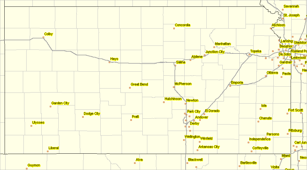
-- Topeka & Shawnee County, Kansas Roughly sixty miles west of Kansas City, the Topeka, KS metro is comprised of five counties and is home to Topeka, the Kansas state capital. This section is focused on tools and data that can be used to examine demographic, social, economic and housing characteristics of a community/city/place in context of a metro or region/county group ... as well as drill-down to neighborhoods. While focused on Topeka, the tools and data reviewed in this section may be applied to hundreds of similar settings across the U.S. Topics: • 01 Topeka City in Context of Metro • 02 Topeka & Shawnee County • 03 Examining Topeka Neighborhood Areas • 04 Examining Topeka Neighborhood Areas by Block Group • 05 Topeka Schools & School Attendance Zones • 06 Topeka Schools, Block Groups & Streets • 07 Topeka School District • 08 Topeka City & ZIP Codes • 09 Congressional Districts & State Legislative Districts • 10 Demographic-Economic Profile • 11 Additional Topics Topeka is located in Shawnee County (20177). The population of Topeka changed from 127,917 in 2010 to 126,808 in 2016; a change of -1,109 (-0.9%). The county population changed from 178,351 to 178,146, a change of -205 (-0.1%) during the same period. Topeka is located in the Topeka, KS MSA (CBSA 45820). The CBSA population changed from 234,280 to 233,068 during the period 2010 to 2016, a change of -1,212 (-0.5%) Among all 933 CBSAs, this CBSA ranked 194th based on 2016 population, 754th based on 2010 to 2016 population change, and 605th based on 2010 to 2016 percent population change. See details in the Topeka Demographic-Economic Profile Topeka Metro in Context of Region The Topeka metro is approximately same size in population (233,000) as Fargo, ND-MN MSA, Appleton, WI MSA and Macon, GA MSA. Determine such population size peer groups for any metro using the metro population estimates/trends data interactive table. Use the CV XE GIS software with associated GIS project to examine characteristics of communities in context of different geographies and patterns. The following view shows metropolitan areas (bold brown boundaries - metropolitan statistical areas -- MSAs) that include the Topeka metro (hatched pattern) in context of MSAs in the region. Urban areas are shown with orange fill patterns. 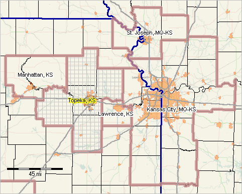 - View developed using the CV XE GIS software. Topeka City in Context of Metro - goto top Topeka is approximately same size in population (127,000) as Santa Clara, CA, Simi Valley, CA, Lafayette, LA and Kent, WA. Determine such population size peer groups for any city using the 2010-2016 city/place population estimates/trends data interactive table. Use the same table to examine demographic characteristics and change for all counties within the metro (or similarly for any metro). The following view shows Topeka city (green fill pattern) in context of the five county metro. 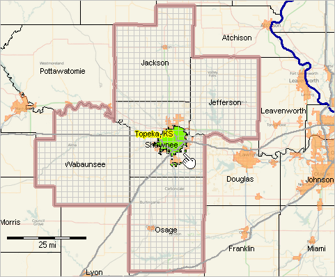 - View developed using the CV XE GIS software. Examine extended demographic characteristics of Topeka, and in context of other cities in the state and demographic peer groups, using these interactive tables: • General Demographics • Social Characteristics • Economic Characteristics • Housing Characteristics • Population and components of change; 2010-2016 -- use interactive table .. consider selecting by metro code -- use tools below table. .. enter the Topeka CBSA 45820 in the edit box to right of Find in CBSA then click Find button. Topeka & Shawnee County - goto top Topeka is wholly located within Shawnee County, KS. Shawnee county, 2016 population of approximately 178,000. It is approximately the same size as Shasta County, CA, Charlotte County, FL, Boone County, MO and Pitt County, NC. Determine such population size peer groups for any county using the 2010-2016 county population estimates/trends data interactive table. The following view shows Topeka city (cross-hatch pattern) patterns in context of urban area (orange fill pattern) and Shawnee County.  - View developed using the CV XE GIS software. Examine extended demographic characteristics of Shawnee County, and in context of other counties in the state and demographic peer groups, using these interactive tables: • General Demographics • Social Characteristics • Economic Characteristics • Housing Characteristics Examining Topeka Neighborhood Areas -- Zoom into Topeka - goto top The following view shows patterns of median household income by census tract based on the 2015 American Community Survey 5-year demographic-economic data (ACS2015). The Topeka city boundary is shown with black boundary. 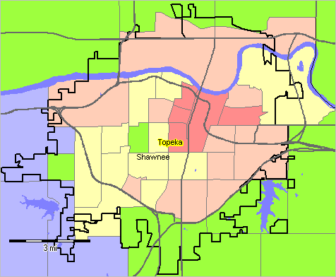 - View developed using the CV XE GIS software. Examine demographic characteristics of these tracts using these demographio-economic interactive tables: • General Demographics • Social Characteristics • Economic Characteristics • Housing Characteristics .. consider selecting by metro/CBSA code -- use tools below table. .. enter the Topeka CBSA 45820 in the edit box to right of CBSA then click CBSA button. Examining Topeka Neighborhood Areas by Block Group - goto top Block groups are geographic components of census tracts. The following view shows patterns of median housing value by block group based on the 2015 American Community Survey 5-year demographic-economic data (ACS2015). Topeka city is shown as a gray cross-hatched overlay. 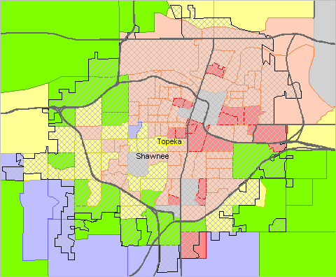 - View developed using the CV XE GIS software. Supplemental Topeka block groups thematic pattern map. This view shows patterns of median housing value by block group (BG) with BGs labeled with number of housing units. Not shown, but included in the GIS shapefile are the number of housing units by year structure built. 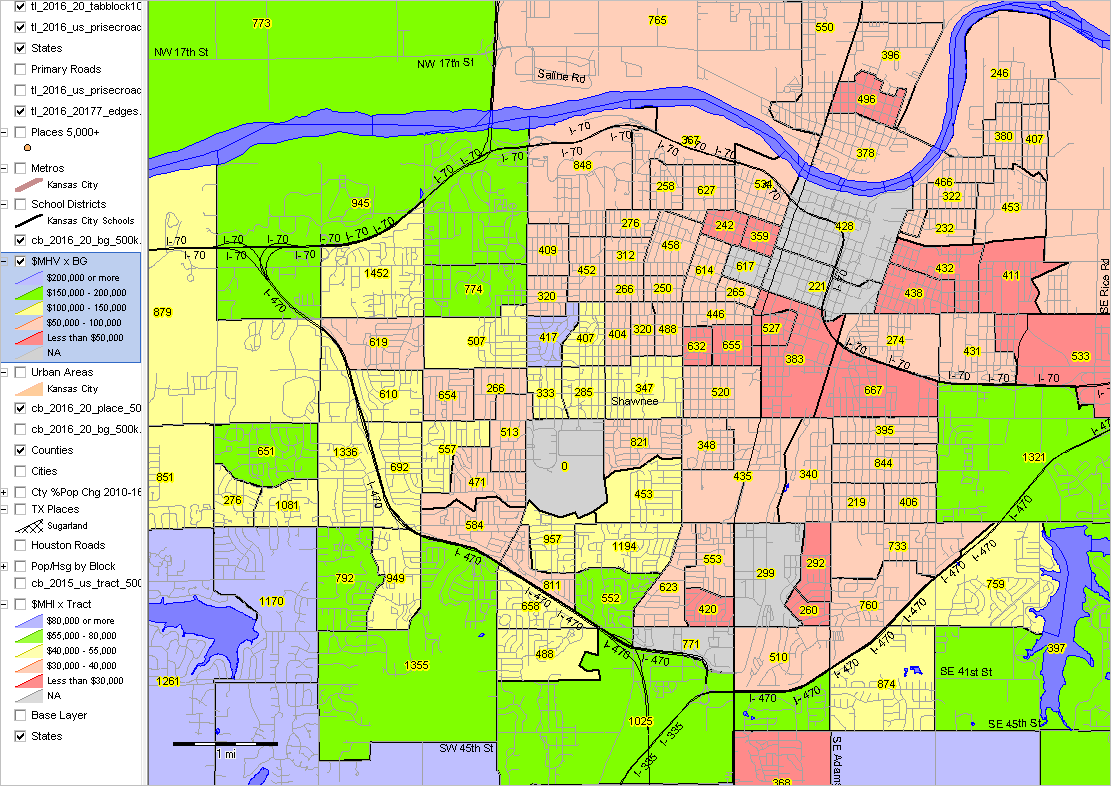 - View developed using the CV XE GIS software. - Click graphic for larger view See more about accessing and using block group demographics Topeka Schools & School Attendance Zones - goto top The following graphic shows elementary school attendance zones as block boundaries and K12 public elementary schools as blue markers in context of Topeka city (red boundary). 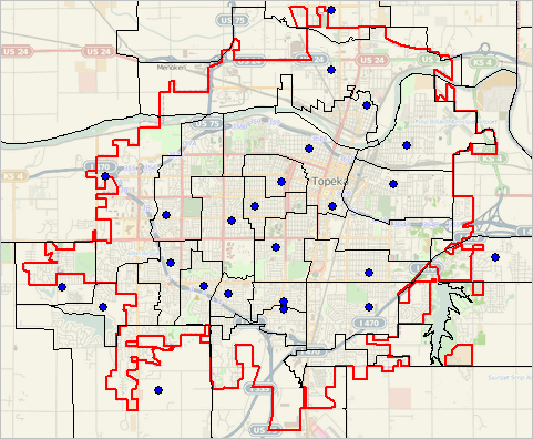 - View developed using the CV XE GIS software. Topeka Schools, Block Groups & Streets - goto top An important feature of using GIS tools and data is the ability to visual analyze the same sets of data in many ways. The following graphic shows two elementary schools (blue markers), block groups (red boundaries) labels with median household income, streets -- intersection to intersection streets shapefile in context of an OpenStreets tile layer. 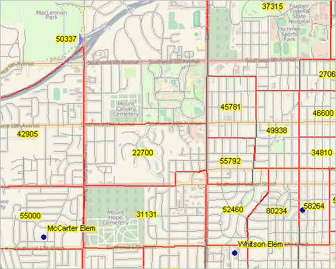 - View developed using the CV XE GIS software. Topeka and Area School Districts - goto top Based on ACS2015 5-year estimates, the school age population of the Topeka School District was 14,718 (resident population ages 5-17 years) with a total population of 95,319. There are 68 school districts in the U.S. with population ages 5-17 years in the 14,000 to 15,000 range. Comparably sized districts to the Topeka School District include Iowa City CSD, IA, Tippecanoe Schools, IN and Grapevine-Colleyville ISD, TX. The following graphic shows school districts and elementary schools (blue markers) in context of Topeka city (red boundary), 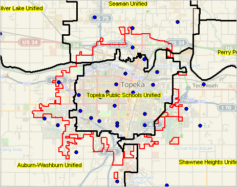 - View developed using the CV XE GIS software. Finances: Sources and Uses of Funds. In fiscal year 2014, Topeka Public Schools spent $11,547 per student (current expenditures). Kansas per student current expenditures in FY 2014 ranged from $4,366 (Andover) to $17,235 (Triplains). Topeka Schools had the 5th largest enrollment. Compare any school district to any other district. See related school district sources and use of funds. Demographic Change/Trends. See how the Topeka School District is changing in terms of total population, school age population and school at population in poverty. Use the School District Trends interactive table. Compare trends/patterns to other districts. Examine extended demographic characteristics of the Topeka School District, and in context of other school districts in the state and demographic peer groups, using these interactive tables: • General Demographics • Social Characteristics • Economic Characteristics • Housing Characteristics .. consider selecting by metro/CBSA code -- use tools below table. .. enter the Topeka CBSA 45820 in the edit box to right of CBSA then click CBSA button. Topeka City & ZIP Codes - goto top The following graphic shows ZIP Code areas (ZCAs - black bold boundary) in context of Topeka city (green cross-hatch pattern). ZCAs are labeled with ZIP code (yellow label) and ACS2014 median household income. Click graphic for larger view. ZCAs are defined as a set of census blocks and differ from USPS ZIP codes used for mail delivery. 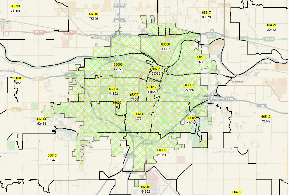 - View developed using the CV XE GIS software. - Click graphic for larger view. Examine extended demographic characteristics of the ZIP Code Areas, and in context of state using these interactive tables: • General Demographics • Social Characteristics • Economic Characteristics • Housing Characteristics ZCA interactive relationship tables: • ZIP Code Area - City Relationship Table • ZIP Code Area - USPS ZIP Code Relationship Table Congressional Districts & State Legislative Districts - goto top This section shows relationships of the 115th Congressional Districts and 2016 vintage state legislative districts. The following four graphics show: • State House Districts - in context of metro • State House Districts - in context of Topeka city - zoom-in • State Senate Districts - in context of metro • State Senate Districts - in context of Topeka city - zoom-in Kansas State House Districts & Metro In the following graphic, the 115th Congressional Districts are shown with a bold orange boundary and state house districts are shown with bold black boundary. Topeka, with green fill pattern, is entirely with in 115th CD KS02. Primary roads shown in orange. 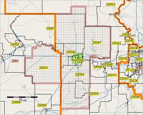 - View developed using the CV XE GIS software. Kansas State House Districts & City In the following graphic, the state house districts are shown with bold black boundary. Topeka, with green hatch pattern, is split by six state house districts. 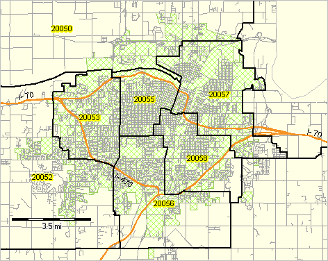 - View developed using the CV XE GIS software. Kansas State Senate Districts & Metro In the following graphic, the 115th Congressional Districts are shown with a bold orange boundary and state senate districts are shown with bold black boundary. Topeka, with green fill pattern, is entirely with in 115th CD KS02. 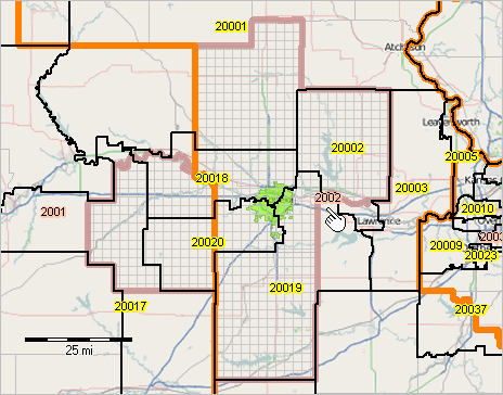 - View developed using the CV XE GIS software. Kansas State Senate Districts & City In the following graphic, the state senate districts are shown with bold black boundary. Topeka, with green hatch pattern, is split by three state senate districts. Primary roads shown in orange. 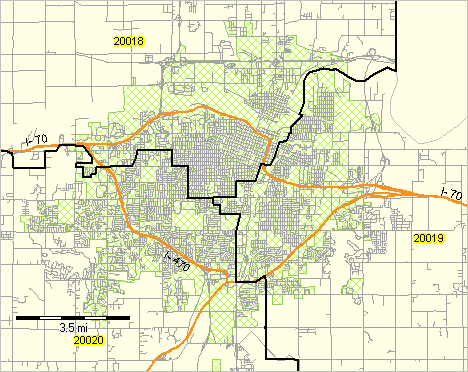 - View developed using the CV XE GIS software. 115th Congressional District Demographic Characteristics. View/compare/rank extended demographic characteristics of individual 115th Congressional Districts based on 2015 ACS 1-year estimates and in context of other districts using these interactive tables: • General Demographics • Social Characteristics • Economic Characteristics • Housing Characteristics State Legislative District Demographic Characteristics. View/compare/rank extended demographic characteristics of individual 2014 State Legislative Districts based on 2015 ACS 5-year estimates and in context of other districts using these interactive tables. Data for the 2016 vintage SLDs are not available until December 2017. • General Demographics • Social Characteristics • Economic Characteristics • Housing Characteristics Topeka Demographic-Economic Profile - goto top • View profile Additional Topics - goto top Other topics that might be added to a more comprehensive "Examining Neighborhoods & Communities" include: • Future of Topeka .. 5 year estimates & projections by tract/county .. examining how market areas and neighborhoods are changing; aggregate to city/county .. projections to 2060 - county • Topeka economy .. county economic profiles .. click Showall button then key in 20177 (any county) below in GEOID edit box and click GEOID button .. table refreshes with county 20177 (Shawnee) with trending economic profile • Housing infrastructure: composition, supply, demand, market .. housing unit patterns and trends .. building permits .. monthly; city, county, metro • Healthcare infrastructure .. health data analytics .. health characteristics .. city, tract • Business establishments by sector .. establishments/employment by sector .. quarterly; county .. ZIP Code business patterns • Employment situation .. employment situation .. monthly; city/county • Topeka Census Tracts .. tract-place equivalence .. there are 39 tracts intersecting with Topeka city; find intersecting tract list for any city/county • Demographic profile for a location .. location-based demographics .. key in an address to view demographic profile. Support Using these Resources - goto top Learn more about accessing and using demographic-economic data and related analytical tools. Join us in a Data Analytics Lab session. There is no fee for these one-hour Web sessions. Each informal session is focused on a specific topic. The open structure also provides for Q&A and discussion of application issues of interest to participants. ProximityOne User Group Join the ProximityOne User Group to keep up-to-date with new developments relating to metros and component geography decision-making information resources. Receive updates and access to tools and resources available only to members. Use this form to join the User Group. Additional Information ProximityOne develops geodemographic-economic data and analytical tools and helps organizations knit together and use diverse data in a decision-making and analytical framework. We develop custom demographic/economic estimates and projections, develop geographic and geocoded address files, and assist with impact and geospatial analyses. Wide-ranging organizations use our tools (software, data, methodologies) to analyze their own data integrated with other data. Follow ProximityOne on Twitter at www.twitter.com/proximityone. Contact us (888-364-7656) with questions about data covered in this section or to discuss custom estimates, projections or analyses for your areas of interest. |
|
|